Download presentation
Presentation is loading. Please wait.

1
CLOUDS

2
HIGH LEVEL CLOUDS High-level clouds form above 20,000 feet (6,000 meters) and since the temperatures are so cold at such high elevations, these clouds are primarily composed of ice crystals. High-level clouds are typically thin and white in appearance, but can appear in a magnificent array of colors when the sun is low on the horizon.

3
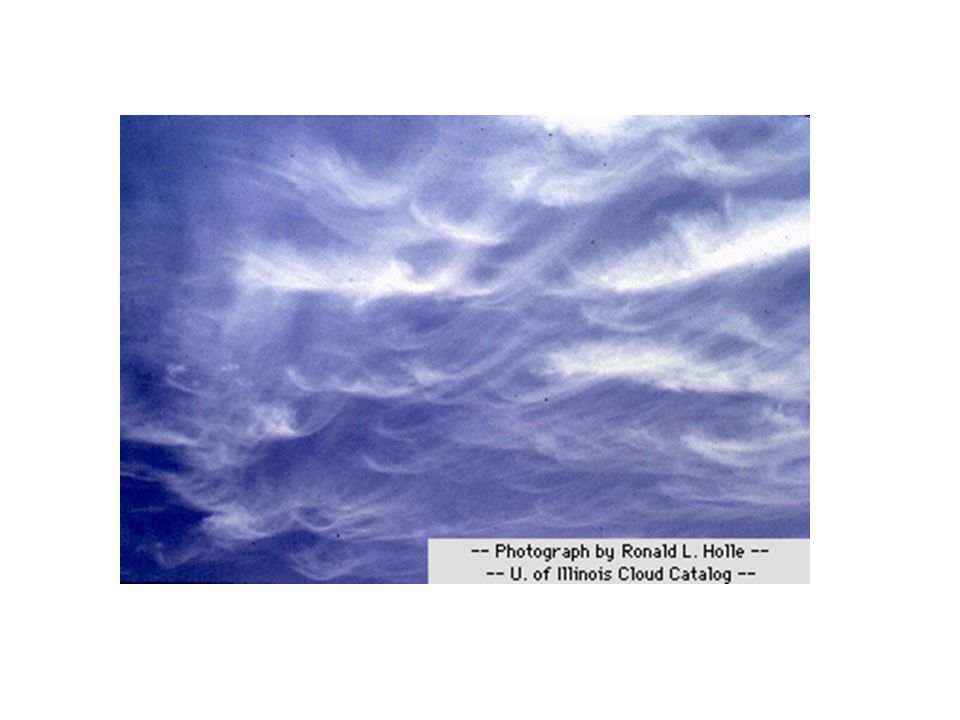
The most common form of high-level clouds are thin and often wispy cirrus clouds. Typically found at heights greater than 20,000 feet (6,000 meters), cirrus clouds are composed of ice crystals that originate from the freezing of supercooled water droplets. Cirrus generally occur in fair weather and point in the direction of air movement at their elevation.
, cirrus clouds are composed of ice crystals that originate from the freezing of supercooled water droplets. Cirrus generally occur in fair weather and point in the direction of air movement at their elevation..")
5
Cirrostratus are sheet-like, high-level clouds composed of ice crystals. Though cirrostratus can cover the entire sky and be up to several thousand feet thick, they are relatively transparent, as the sun or the moon can easily be seen through them. These high-level clouds typically form when a broad layer of air is lifted by large-scale convergence. convergence

6
Sometimes the only indication of their presence is given by an observed halo around the sun or moon. Halos result from the refraction of light by the cloud's ice crystals. Cirrostratus clouds, however, tend to thicken as a warm front approaches, signifying an increased production of ice crystals. As a result, the halo gradually disappears and the sun (or moon) becomes less visible.halorefractionwarm front
 becomes less visible.halorefractionwarm front.")
7
When the sun is low on the horizon, cirrostratus clouds can appear in a magnificent array of colors as longer wavelengths of sunlight (red, yellow, and orange) are reflected off of the clouds.reflected
 are reflected off of the clouds.reflected")
8
MIDDLE LEVEL CLOUDS The bases of mid-level clouds typically appear between 6,500 to 20,000 feet (2,000 to 6,000 meters). Because of their lower altitudes, they are composed primarily of water droplets, however, they can also be composed of ice crystals when temperatures are cold enough.

9
Altocumulus clouds are composed primarily of water droplets and are located between 6,500 and 20,000 feet (2,000 to 6,000 meters) above the ground.
 above the ground.")
10
Altocumulus may appear as parallel bands (top photograph) or rounded masses (bottom photograph). Typically a portion of an altocumulus cloud is shaded, a characteristic which makes them distinguishable from the high-level cirrocumulus. Altocumulus clouds usually form by convection in an unstable layer aloft, which may result from the gradual lifting of air in advance of a cold front. The presence of altocumulus clouds on a warm and humid summer morning is commonly followed by thunderstorms later in the day.convectioncold front

11
LOW LEVEL CLOUDS Low clouds are of mostly composed of water droplets since their bases generally lie below 6,500 feet (2,000 meters). However, when temperatures are cold enough, these clouds may also contain ice particles and snow.

12
Nimbostratus are dark, low-level clouds accompanied by light to moderately falling precipitation. Low clouds are primarily composed of water droplets since their bases generally lie below 6,500 feet (2,000 meters). However, when temperatures are cold enough, these clouds may also contain ice particles and snow.
. However, when temperatures are cold enough, these clouds may also contain ice particles and snow..")
14
Stratocumulus clouds generally appear as a low, lumpy layer of clouds that is sometimes accompanied by weak intensity precipitation. Stratocumulus vary in color from dark gray to light gray and may appear as rounded masses, rolls, etc., with breaks of clear sky in between.

15
VERTICALLY-DEVELOPED CLOUDS Probably the most familiar of the classified clouds is the cumulus cloud. Generated most commonly through either thermal convection or frontal lifting, these clouds can grow to heights in excess of 39,000 feet (12,000 meters), releasing incredible amounts of energy through the condensation of water vapor within the cloud itself.thermal convectionfrontal liftingcondensation
, releasing incredible amounts of energy through the condensation of water vapor within the cloud itself.thermal convectionfrontal liftingcondensation.")
16
Fair weather cumulus have the appearance of floating cotton and have a lifetime of 5-40 minutes. Known for their flat bases and distinct outlines, fair weather cumulus exhibit only slight vertical growth, with the cloud tops designating the limit of the rising air. Given suitable conditions, however, harmless fair weather cumulus can later develop into towering cumulonimbus clouds associated with powerful thunderstorms.cumulonimbus clouds

17
Fair weather cumulus are fueled by buoyant bubbles of air, or thermals, that rise upward from the earth's surface. As they rise, the water vapor within cools and condenses forming cloud droplets. Young fair weather cumulus have sharply defined edges and bases while the edges of older clouds appear more ragged, an artifact of cloud erosion. Evaporation along the cloud edges cools the surrounding air, making it heavier and producing sinking motion (or subsidence) outside the cloud. thermalswater vapor within cools and condenses
 outside the cloud. thermalswater vapor within cools and condenses.")
18
The downward motion inhibits further convection and the growth of additional thermals from below, which is why fair weather cumulus typically have expanses of clear sky between them. Without a continued supply of rising air, the cloud begins to erode and eventually disappears.convection

19
Cumulonimbus clouds

20
Cumulonimbus clouds (Cb) are much larger and more vertically developed than fair weather cumulus. They can exist as individual towers or form a line of towers called a squall line. Fueled by vigorous convective updrafts (sometimes in excess 50 knots), the tops of cumulonimbus clouds can easily reach 39,000 feet (12,000 meters) or higher.fair weather cumulusindividual towerssquall line
, the tops of cumulonimbus clouds can easily reach 39,000 feet (12,000 meters) or higher.fair weather cumulusindividual towerssquall line.")
21
Lower levels of cumulonimbus clouds consist mostly of water droplets while at higher elevations, where temperatures are well below 0 degrees Celsius, ice crystals dominate. Under favorable atmospheric conditions, harmless fair weather cumulus clouds can quickly develop into large cumulonimbus clouds associated with powerful thunderstorms known as supercells.fair weather cumulussupercells

22
SupercellsSupercells are large thunderstorms with deep rotating updrafts and can have a lifetime of several hours. Supercells can produce frequent lightning, large hail, damaging winds, and tornadoes.lightninghaildamaging windstornadoes

Similar presentations


>")


