Download presentation
Presentation is loading. Please wait.

1
HURRICANE EARL SUMMARY UPDATED SEPTEMBER 3, 2010 8:00 AM

2
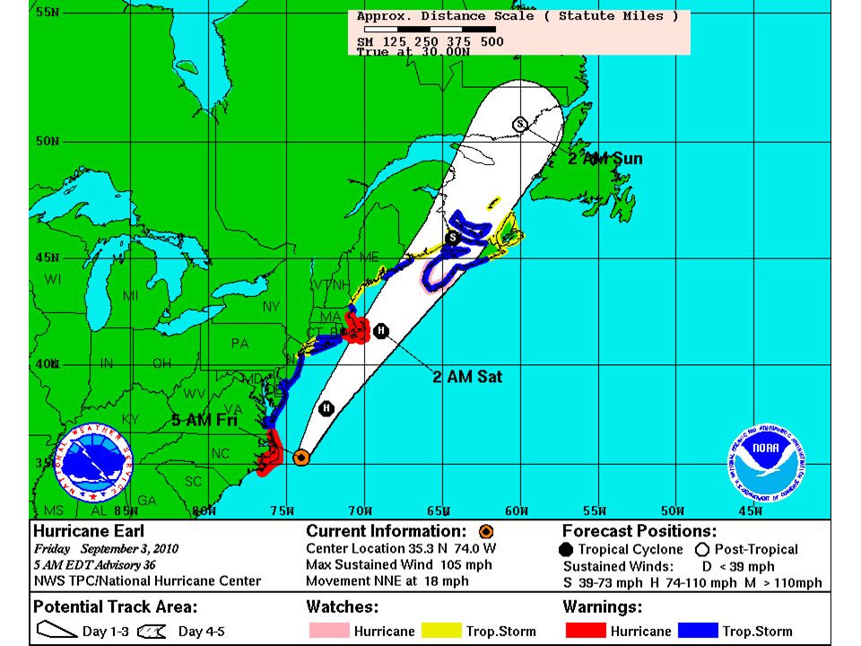
Hurricane Earl – 6:15 AM

6
HURRICANE EARL PROJECTION Earl will likely pass 50 to 100 miles southeast of Nantucket around midnight tonight – Probably as a Category 1 hurricane Preparations for Earl should be complete by early this afternoon for Cape Cod, islands, and immediate south coast Primary area of concern continues to be Cape Cod, Nantucket and Martha’s Vineyard

7
HURRICANE EARL WATCHES/WARNINGS Hurricane Warning: – Westport to Hull But primary concern is with Cape Cod, Martha’s Vineyard, and Nantucket – especially outer Cape and Nantucket Tropical Storm Warning – Rest of southern New England coastline

8
SOUTHERN NEW ENGLAND IMPACTS Marine High seas, high surf, and dangerous rip currents through Saturday – Along most ocean exposed beaches whether south or east facing – High surf and dangerous rip currents may be the greatest risk to life – Seas over open coastal waters 10 to 20 feet to left of track 20 to 30+ feet very near track 30 to 40+ feet to right of the track

9
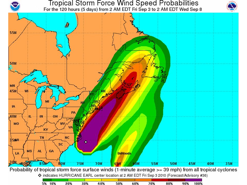
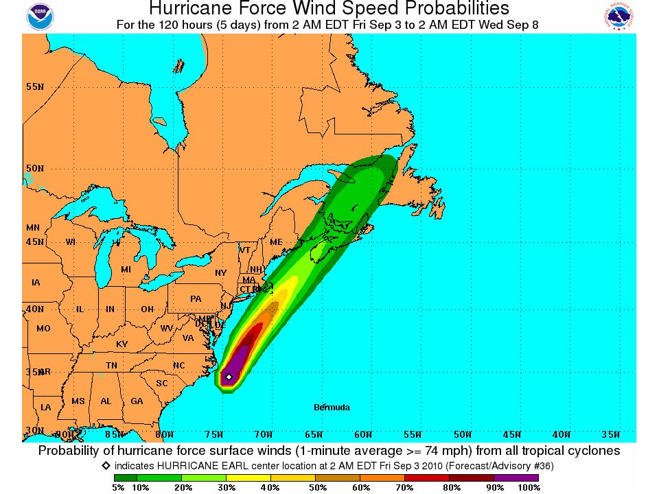
HURRICANE EARL IMPACTS Wind Tropical Storm Force winds Cape Cod and the Islands with hurricane force gusts possible – especially over the outer Cape and Nantucket Tropical Storm force gusts likely rest of Massachusetts and Rhode Island coastline – Possibility of a short duration of sustained tropical storm force winds immediate Rhode Island south coast, including Block Island, Buzzards Bay coast, and Plymouth County coast Tropical Storm force gusts possible remainder of southeast New England along and southeast of a Boston to Providence line Any shift to the west of the track is looking less likely with time but would shift stronger winds to NW

10
WIND SPEEDS Outer Cape and Nantucket – NE and then N 40 to 50 mph with gusts 70 to 80 mph possible Rest of Cape and Martha’s Vineyard – NE and then N 30 to 40 mph with gusts 60 to 70 mph possible Rhode Island coast (incl. Block Island) and Plymouth County coast in Massachusetts – NE to N winds 25 to 35 mph with gusts 50 to 60 mph Rest of immediate Massachusetts coast and along Boston to Providence corridor: – NE to N to NW winds 20 to 30 mph with gusts 40 to 50 mph possible
 and Plymouth County coast in Massachusetts – NE to N winds 25 to 35 mph with gusts 50 to 60 mph Rest of immediate Massachusetts coast and along Boston to Providence corridor: – NE to N to NW winds 20 to 30 mph with gusts 40 to 50 mph possible.")
11
WIND TIMELINE Gusts to near Tropical Storm force arrive south coast and islands around 3 to 5 PM and spread north to Cape Ann by 6 or 7 PM Strongest winds for a 3 to 6 hour duration between 8 PM and 2 AM for most locations Winds becoming NW and diminishing 4 to 8 AM W to NW winds gusting to 30 knots Saturday late morning and afternoon

12
HURRICANE EARL IMPACTS Heavy Rain/Flooding 2 to 4 inches of rain with spot higher amounts up to 6 inches Cape Cod, Martha’s Vineyard, Nantucket, as well as adjacent southeast Massachusetts – Flash Flood Watch in this area – Urban poor drainage flooding most likely problem 1 to 3 inches for Rhode Island and rest of eastern Massachusetts 1 inch or less near CT River Valley Heaviest rain 6 PM to midnight

13
HURRICANE EARL IMPACTS Storm Surge Flooding Storm surge of 2 to 4 feet may cause minor flooding along vulnerable portions of the Nantucket, Chatham and Martha’s Vineyard shoreline during this evening’s high tide Surge of around 2 feet may cause spotty minor coastal flooding Narragansett Bay – not a serious concern Rain runoff will come after high tide along Narragansett Bay Splash over around the time of the late afternoon high tide ocean exposed RI south coast due to large breakers Up to 2 feet of surge rest of Massachusetts east coast during the evening high tide with splash over possible Minor storm surge flooding possible for Wellfleet and Provincetown harbors after Earl passes Friday night – 3 to 6 foot surge possible 2 to 4 AM but between high tides

14
POST HURRICANE EARL Mostly Sunny and gusty Saturday – NW wind gusts 30 to 35 mph Swells, surf, and rip currents subsiding during Saturday but still dangerous May have some lingering rip current concerns on Sunday…especially east facing coasts

Similar presentations


 CONFERENCE CALL Wednesday 2:30 PM February 6, 2013.>")


