Download presentation
Presentation is loading. Please wait.

1
Purdue Status Report Summer Meeting 2012 Midwest Spatial Decision Support Interest Group EPA Region 5 July 9, 2012 Bernie Engel, Larry Theller, Youn Shik Park, Laurent Ahiablame. Agricultural and Biological Engineering Purdue University

2
Topics L-THIA LID improvements L-THIA Extension for ArcGIS Load Duration Curve (LDC) tool improvements Fox River Project update (L-THIA Owls) Driftwatch Update
 tool improvements Fox River Project update (L-THIA Owls) Driftwatch Update")
3
Web-based LDC Tool STORET/WQX Web-based LDC Tool and STORET/WQX

4
* USEPA, 2007. An approach for using load duration curves in the development of TMDLs. U. S. Environmental Protection Agency Flow and Load Duration Curves Simple, quick, and statistical approach Cumulative frequency of historic data over a specified period

5
WQ This table is for WQ data. To plot a Load Duration Curve (LDC), two data are required: water quality WQwater quality (WQ) data flow dataflow data flow This table is for flow data.
, two data are required: water quality WQwater quality (WQ) data flow dataflow data flow This table is for flow data..")
6
Option 5. “Copy and paste” the data from spreadsheet. (e.g. Microsoft Excel) Option 1 Option 1. Download the data from EPA, and upload it. Option 2 Option 2. Find the location on Google Maps, then it will give USGS WQ and flow together. Option 3 Option 3. Upload your file. Option 4. Use EPA STORET Data Warehouse WQ How is WQ data prepared ?
 Option 1 Option 1. Download the data from EPA, and upload it. Option 2 Option 2. Find the location on Google Maps, then it will give USGS WQ and flow together. Option 3 Option 3. Upload your file. Option 4. Use EPA STORET Data Warehouse WQ How is WQ data prepared .")
7
WQ Option 1. EPA WQ data Upload the downloaded file. Select WQ parameter.

8
WQ Option 2. USGS WQ data Select WQ parameter and set period in the following page.

9
Option 3. Upload the file or “Copy and Paste”

10
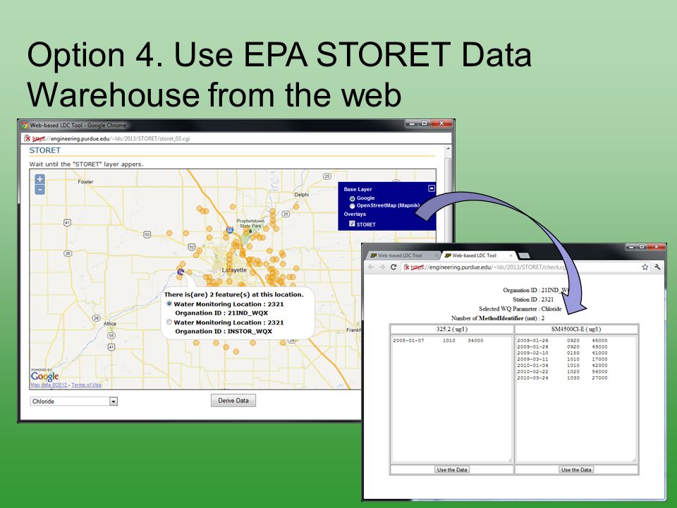
Option 4. Use EPA STORET Data Warehouse from the web

12
Flow How is Flow data prepared ? Option 1 Option 1. Find the USGS gage via Google Maps Option 2 Option 2. Upload your file Option 3 Option 3. Copy and paste the data Once flow data table is filled out, Flow Duration Curve (FDC) plot is available; assists checking missing and negative values.
 plot is available; assists checking missing and negative values..")
13
And then... Select period to plot FDC and LDC, and set additional options. surface flow IF the surface flow percentage is greater than a certain value needs to be plotted, set the percentage value and check it. growing season IF growing season needs to be plotted, define the period and check it.

14
Select to see the other plots in the page or download files. background mode LOADEST runs in background mode. It may take a long time, if the data is very long-term (tens of minutes). send an e-mail The Web-based LDC Tool will send an e-mail, when the model is finished.
. send an The Web-based LDC Tool will send an , when the model is finished..")
15
To visit the results web-page, click the link.

16
The display (pre-LOADEST execution)
")
17
The results... (after LOADEST execution)
")
18
Web-based LDC Tool and STEPL Identifying Required Reduction Observed Annual Load Web-based LDC Tool Calibration of Simulated Annual Load Simulation of BMP Effect EPA STEPL WEB

19
EPA STEPL WEB

20
EPA STEPL (introduction) Spreadsheet Tool for the Estimation of Pollutant Load (STEPL - computes surface runoff, sediment load, and nutrient loads (N,P,BOD), - estimates various BMP effects.* The benefits of the model: - a user-friendly VB interface and Microsoft Excel, - easy to prepare inputs through STEPL On-Line Data Access System (http://it.tetratech-ffx.com/steplweb/steplweb.html). * Tetra Tech, Inc. 2011. User’s Guide Spreadsheet tool for the estimation of pollutant load (STEPL) version 4.1. Tetra Tech, Inc. 10306 Eaton Place, Suite 340 Fairfax, VA 22003.
 version 4.1. Tetra Tech, Inc Eaton Place, Suite 340 Fairfax, VA")
21
Purdue “EPA STEPL WEB” (Current Work) Identical program flow Easy to use and easy accessibility Long-term daily precipitation data from CLIGEN model Easy to change any factor of DBs stored in the server
 Identical program flow Easy to use and easy accessibility Long-term daily precipitation data from CLIGEN model Easy to change any factor of DBs stored in the server")
22
Purdue “EPA STEPL WEB” (Watershed and CLIGEN) A B C D A: Num. of subwatersheds, Gully Formation impaired streambanks B: Inputs related to watershed C: Nationwide CLIGEN stations map D: County data for USLE factors

23
Purdue “EPA STEPL WEB” (BMP inputs) A: BMP form as new tab B: Urban BMP window A B
 A: BMP form as new tab B: Urban BMP window A B")
24
Purdue “EPA STEPL WEB” (Future Work) Annual groundwater estimation with reasonable scientific evidence Capability to handle watershed information file from STEPL On-Line Data Access System Cooperation with Web-based LDC Tool
 Annual groundwater estimation with reasonable scientific evidence Capability to handle watershed information file from STEPL On-Line Data Access System Cooperation with Web-based LDC Tool")
25
Leverage Funding US Corp of Engineers USEPA NEIEN Purdue University Kangwon National University

Similar presentations


 Tracking Thursday, May 31, 2012 Martin Hurd, Vladislav Royzman, Tetra Tech, Inc. Brian Burch, Megan Thynge,>")


>")


 and its Modeling Extensions>")


 and data needs for the Beaver Lake watershed.’One.>")


