Download presentation
Presentation is loading. Please wait.

1
NWS Hydrology Operations & Tools for Decision Makers 2012 Tropical Season Michael Moneypenny, Hydrologist NWSFO Raleigh, NC The term “hurricane” has its origin in the religions of past civilizations. The Mayan storm god was named Hunraken. In addition, a god considered evil by the Taino people of the Caribbean was called Huracan.

4
Things to Think About Every three years on average, the U.S. is struck five times, and two of those are major hurricanes. From a Mason-Dixon Hurricane Awareness Poll: – 87% would evacuate if asked to do so, but almost all would want to take pets – 56% of individuals did not have a family disaster plan – 54% of individuals do not feel vulnerable to a hurricane, or related tornado or flooding – Most individuals think the forecast path of the storm is the most unreliable part of the forecast Every three years on average, the U.S. is struck five times, and two of those are major hurricanes. From a Mason-Dixon Hurricane Awareness Poll: – 87% would evacuate if asked to do so, but almost all would want to take pets – 56% of individuals did not have a family disaster plan – 54% of individuals do not feel vulnerable to a hurricane, or related tornado or flooding – Most individuals think the forecast path of the storm is the most unreliable part of the forecast

5
Population State population has increased to 8.4 million Coastal populations have more than quadrupled Top 5 most populated counties Top 5 most densely populated counties

6
Population and Impacts Top 5 Fastest Growing Counties and Largest Municipalities A Hazel or Hugo sized-storm moving from SE coast into central A Hazel or Hugo sized-storm moving from SE coast into central NC would impact the most densely populated areas in the state. NC would impact the most densely populated areas in the state. Winds in excess of 90 Mph along with 8-10 inches of rain would Winds in excess of 90 Mph along with 8-10 inches of rain would cut all major east-west and north-south roads in the state. cut all major east-west and north-south roads in the state.

7
Tropical Cyclone Track Forecast Error has been Shrinking

8
1970 48-hour forecast point over Wilmington, NC Average error = 300 nautical miles Now 48-hour forecast point over Wilmington, NC Average error = 80 nautical miles

9
Tropical Cyclone Intensity Forecast Error has shown only Modest Improvement

11
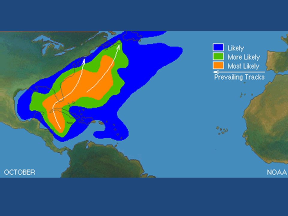
Tropical Cyclone Climatology

12
Percentage of Annual Rainfall Attributed to Tropical Cyclone Activity

16
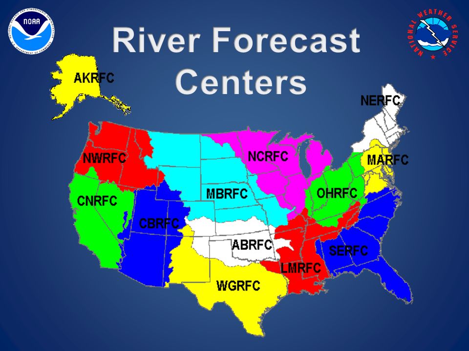
Major Inputs into the River Forecast Process Physical and Climatological Variables Topography = slope, channel geometry, presence of lakes Land use (urban = fast runoff, agriculture = better infiltration) Season = evaporation rate, public demand, transpiration Shorter Duration Variables Antecedent rainfall = Soil moisture Current river and stream levels / discharge Forecast Variables Quantitative precipitation forecast Temperature
 Season = evaporation rate, public demand, transpiration Shorter Duration Variables Antecedent rainfall = Soil moisture Current river and stream levels / discharge Forecast Variables Quantitative precipitation forecast Temperature")
17
www.weather.gov/rah

18
Major Inputs into the River Forecast Process Physical and Climatological Variables Topography = slope, channel geometry, presence of lakes Land use (urban = fast runoff, agriculture = better infiltration) Season = evaporation rate, public demand, transpiration Shorter Duration Variables Antecedent rainfall = Soil moisture Current river and stream levels / discharge Forecast Variables Quantitative precipitation forecast Temperature
 Season = evaporation rate, public demand, transpiration Shorter Duration Variables Antecedent rainfall = Soil moisture Current river and stream levels / discharge Forecast Variables Quantitative precipitation forecast Temperature")
19
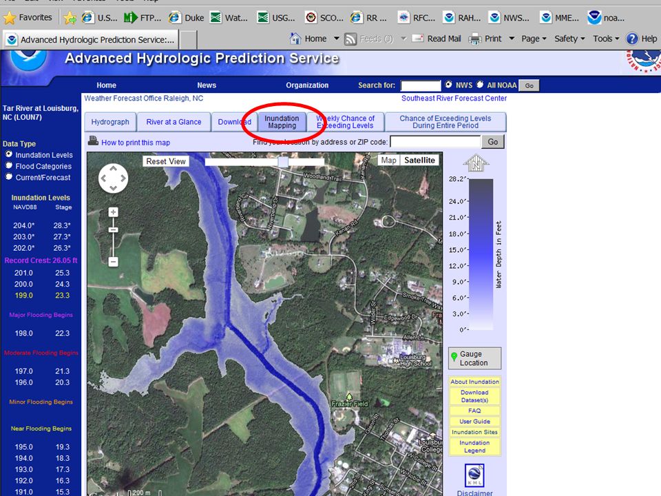
Viewing the Forecast

21
So, How Do We Account for Potential Forecast Error?

22
There is occasionally potential for heavier rainfall than was input into the official river forecast. We need to quantify and evaluate this uncertainty. EM has a need for contingency river forecasts, as decisions to deploy manpower and other resources must be made in the 24 to 48 hour time frame. The need is not for exact forecast stage readings, but rather, a ‘yes or no’ answer to the question “Is it going to flood?”, and a general idea as to the severity and location.

24
http://www.srh.noaa.gov/serfc/?n=mmefsfaq

30
http://www.noaawatch.gov/briefing.phpwww.noaawatch.gov/briefing.php

31
Presentation is Available to Download at: www.weather.gov/rah/downloads/HydroWebinar2012.pptx Link for the Toolbox www.erh.noaa.gov/rah/hydro/reference/river_toolbox.htm

32
Contact Information Michael Moneypenny Hydrologist NWS Raleigh Michael.Moneypenny@noaa.gov (919) 515-8209 ext.224 Nick Petro Warning Coordination Meteorologist NWS Raleigh Nicholas.Petro@noaa.gov (919) 515-8209 ext.223
 ext.224 Nick Petro Warning Coordination Meteorologist NWS Raleigh (919) ext.223")
Similar presentations


Impact on fresh water resources 1. Change in precipitation – Increase flooding – Increase in northern high latitude during the winter, and south-east.>")


 Cycle. Surface Water Oceans Rivers and streams Lakes and ponds Springs – groundwater becomes surface water.>")

