Download presentation
Presentation is loading. Please wait.

1
Classroom presentations to accompany Understanding Earth, 3rd edition prepared by Peter Copeland and William Dupré University of Houston Chapter 12 The Hydrologic Cycle and Groundwater

2
Hydrologic Cycle and Groundwater M. L. Sinibaldi/Stock Market

3
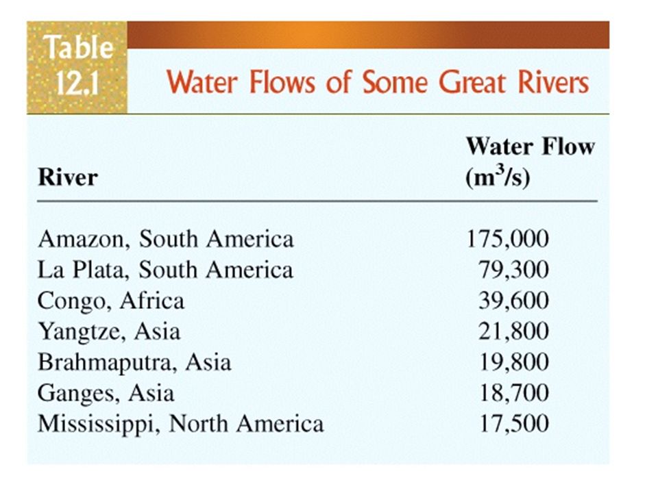
Groundwater The study of groundwater and its effects is called Hydrology. Uses of Water: LivingEngineeringRecreation DrinkingCoolingSwimming PhotosynthesizingHeatingFishing RespiringCleaningSailing MetabolizingFlushingSkating IrrigatingSkiing

4
Fig. 12.1 Distribution of H 2 O on Earth

5
Uses of Groundwater Why is groundwater such a valuable resource? 1.Abundant - 70 times more in the subsurface than in surface reservoirs. 2.Because groundwater moves so slowly it is stored in the earth and remains available even in dry periods. 3.In some regions groundwater flows from humid environments to dry ones, making water available.

6
Groundwater Water contained in spaces within soil, bedrock, and regolith Less than 1% of all H 2 O on Earth 40 times more abundant than water found in lakes and streams

7
Hydrologic Cycle Fig. 12.2

8
Rain Shadow Deserts Fig. 12.3

9
Fig. 12.4a Average Annual Precipitation in the U.S.

10
Average Annual Runoff in the U.S. Fig. 12.4b

11
Fig. 12.5 Swamps as Reservoirs

13
Groundwater terms zone of aeration zone of aeration: portion of soil and rock near the surface in which open spaces are filled primarily with air (a.k.a vadose zone) saturated zone saturated zone: zone in which pore spaces are filled with water water table water table: boundary between zone of aeration and saturated zone
 saturated zone saturated zone: zone in which pore spaces are filled with water water table water table: boundary between zone of aeration and saturated zone")
14
Geologic activity of groundwater Dissolution (most important in carbonates and evaporites) Cementation Replacement
 Cementation Replacement")
15
Springs Locations where a perched water table intersects the ground

16
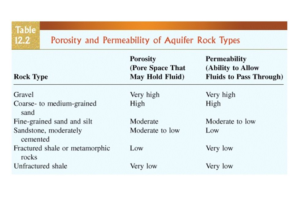
Soils and rocks are not completely solid. porosity: portion of volume of a material that consists of open spaces permeability: measure of the speed at which fluid can travel through a porous medium Imagine two vertical pipes, one filled with gravel, one with sand. Out of which one will the water flow faster?

17
Fig. 12.7a Porous Sandstone

18
Fig. 12.7b Cemented Sandstone

19
Fig. 12.7c Well-sorted Sandstone

20
Poorly-sorted Sandstone Fig. 12.7d

21
Unfractured Shale Fig. 12.7e

22
Fractured Shale Fig. 12.7f

23
More groundwater terms aquifer aquifer: body of rock that is sufficiently water permeable to yield economically significant quantities to wells and springs aquitard aquitard: body of rock that retards but does not prevent flow of water to or from an adjacent aquifer aquiclude aquiclude: body of relatively impermeable rock that is capable of absorbing water slowly but does not transmit it rapidly enough to supply a well or spring

25
Fig. 12.8 Groundwater Table

26
Groundwater Movement in Temperate Regions Fig. 12.9

27
Wet Period Fig. 12.10

28
Dry Period Fig. 12.10

29
Fig. 12.11 Confined Aquifer

30
Fig. 12.12 Perched Water Table

31
Fig. 12.13 Drawdown Due to Pumping

32
Fissures and Depressions Caused by Overpumping Fig. 12.13 James W. Borchers/USGS

33
Saltwater Intrusion Fig. 12.15

34
Rates of groundwater movement Slow to very slow (depending on permeability) Generally within the range of 10 to 100 cm per day
 Generally within the range of 10 to 100 cm per day")
35
Darcy’s Law Q = discharge (m 3 /sec) A = cross-sectional area (m 2 ) K = coefficient of permeability (m/sec) h 1 = beginning height (m) h 2 = ending height (m) l = length of flow (m) Q = AK(h 1 – h 2 ) l
 A = cross-sectional area (m 2 ) K = coefficient of permeability (m/sec) h 1 = beginning height (m) h 2 = ending height (m) l = length of flow (m) Q = AK(h 1 – h 2 ) l")
36
Fig. 12.16 Darcy’s Law

37
Fig. 12.17 U.S. Groundwater Withdrawals 1950–1995

38
Ogallala Aquifer: “Mining” Groundwater

39
Fig. 12.18 David Muench

40
Fig. 12.19 Sinkhole in Florida Leif Skoogfors/Woodfin Camp.

41
Major Features of Karst Topography Fig. 12.20

42
Water Quality and Groundwater Movement Fig. 12.21

43
Fig. 12.22 Groundwater Contamination

44
Fig. 12.23 Groundwater Distribution in a Typical Section of Continental Crust

45
Fig. 12.24 Geyser Peter Kresan

Similar presentations


 Capillary.>")


>")


