Download presentation
Presentation is loading. Please wait.

1
Landscape Treatment Prioritization to Reduce Northern Spotted Owl Habitat Loss from Wildfire: A Test Case Using Fire Regime and Condition Class on the Klamath RD Dr. Gregg Riegel, Ecologist, Central Oregon Ecology Program, Deschutes NF Co-authors: Jane Kertis, Fire Ecologist, USFS Sarah Malaby, Fremont-Winema NF John Foster, Fire Ecologist, TNC Lois Shoemaker, Bio. Tech, Fremont-Winem, NF

3
District Issues Loss of bald eagle habitat Loss of bald eagle habitat Threats of catastrophic fire to spotted owl habitat Threats of catastrophic fire to spotted owl habitat Loss of variable stand and landscape composition and structure Loss of variable stand and landscape composition and structure

4
Project Goals Develop strategic plan to reduce fuels to improve landscape resiliency appropriate Restore landscape to appropriate composition and structure to support owls and bald eagles

5
Process Conduct FRCC mapping/analysis Conduct FRCC mapping/analysis Develop a current fire risk assessment Develop a current fire risk assessment Identify other issues (WUI, nest site/key owl and bald eagle habitat, fish habitat) Identify other issues (WUI, nest site/key owl and bald eagle habitat, fish habitat) Create priority areas Create priority areas Recommend treatment types and timing Recommend treatment types and timing
 Identify other issues (WUI, nest site/key owl and bald eagle habitat, fish habitat) Create priority areas Create priority areas Recommend treatment types and timing Recommend treatment types and timing")
6
FRCC Mapping Condition Class 1. Vegetation-fuel class 2. Fire frequency/severity

7
FRCC Mapping: Vegetation Fuel Classes 1. Determine PNVGs/BPS 2. Define appropriate “landscapes” 3. Crosswalk current vegetation to seral stage 4. Field verification of seral stages 6. Compare reference to current

8
FRCC Mapping Determine Biophysical Settings From: 16 Plant Associations To: 2 Biophysical Settings Red fir----- Mixed conifer-----

10
FRCC Mapping: Define Appropriate Landscapes Landscape size considerations: Historical fire sizesHistorical fire sizes Landform and TopographyLandform and Topography Watershed boundariesWatershed boundaries

11
Crosswalk Current Vegetation to Seral Stage Size Class Canopy Cover Seral Code Seral Stage Non-forestNAAPost-replacement Sapling/Pole, Small > 40% BMid-Closed Sapling/Pole, Small < 40% CMid-Open Medium, Large, Really Big < 40% DLate-Open Medium, Large, Really Big > 40% ELate-Closed

12
FRCC Mapping Field Verification of Seral Stages Field verification of: Plant Association to PNVG Plant Association to PNVG Current vegetation attributes (size class, canopy cover) Current vegetation attributes (size class, canopy cover) Current seral stages Current seral stages
 Current vegetation attributes (size class, canopy cover) Current seral stages Current seral stages")
13
Mixed Conifer Seral Stages B. Mid Seral Closed E. Late Seral Closed C. Mid Seral Open

14
Red Fir Seral Stages B. Mid Seral Closed E. Late Seral Closed

15
FRCC Current Seral Stage Distribution

16
FRCC Veg-Fuel Analysis Mixed Conifer NorthMiddleSouth Seral Stage ReferenceCurrentSIMCurrentSIMCurrentSIM A514565155 B 251544152615 C3521 19 34 D40664433 E5345275225 SUM524862 DEP485238 VF-CC222

17
FRCC Veg-Fuel Analysis Red Fir NorthMiddleSouth Seral Stage ReferenceCurrentSIMCurren t SIMCurre nt SIM A10993399 B 2410181088 C516585135 D40775555 E35443566356535 SUM665862 DEP344238 VF-CC222

18
Condition Class A categorical measure of departure: Condition Class I = within natural or historical range of variability (NRV or HRV) Condition Class II = moderate departure from HRV Condition Class III = extreme departure
 Condition Class II = moderate departure from HRV Condition Class III = extreme departure")
19
0%25%75%-25%-75% diff Similar Over- represented Abundant Under- represented Trace Relative amount

20
Using FRCC Veg-Fuel Class Abundance as Treatment Guidance NorthMiddleSouth SeralMCONRFIRMCONRFIRMCONRFIR AOverSimilar TraceAbundantSimilar BOver Similar CUnderAbundantUnderOverSimilarOver DTrace EAbundantSimilarAbundantOverAbundantOver

21
FRCC Mapping: Fire Frequency and Severity Condition Class Used local fire history information to determine reference frequency and severity for each PNVG Used local fire history information to determine reference frequency and severity for each PNVG Calculated MFI—(# of fires-1/100) to determine current fire frequency.. Calculated MFI—(# of fires-1/100) to determine current fire frequency.. Used expert knowledge to determine current fire severity. Current fire severities estimated at 75% compared to reference mixed conifer 5%, red fir 10% Used expert knowledge to determine current fire severity. Current fire severities estimated at 75% compared to reference mixed conifer 5%, red fir 10%
 to determine current fire frequency.. Used expert knowledge to determine current fire severity. Current fire severities estimated at 75% compared to reference mixed conifer 5%, red fir 10% Used expert knowledge to determine current fire severity. Current fire severities estimated at 75% compared to reference mixed conifer 5%, red fir 10%.")
22
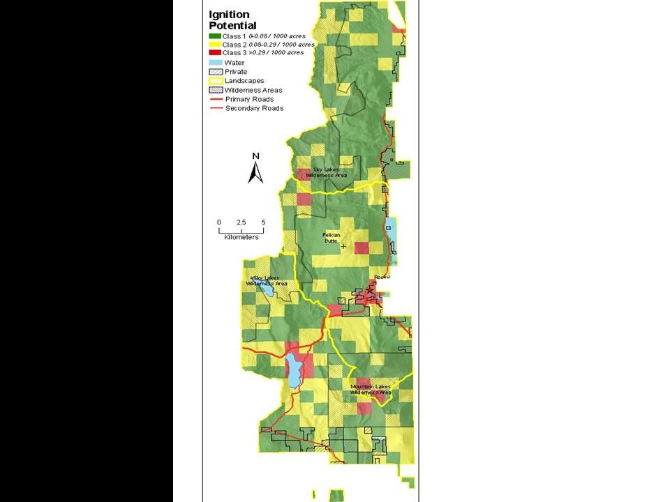
Current Fire Risk Assessment 3 Components: 1. Probability of ignition 2. Fire behavior potential 3. Composite fire risk

23
Probability of Ignition Fire atlas records from 1960-2001 Used sections as cell size Used sections as cell size Counted all human caused (excluding equipment) and lightning ignitions Counted all human caused (excluding equipment) and lightning ignitions Rated low (0-4 fires/section/40 yrs); moderate (5-10 fires); high (> 10 fires) Rated low (0-4 fires/section/40 yrs); moderate (5-10 fires); high (> 10 fires)
 and lightning ignitions Counted all human caused (excluding equipment) and lightning ignitions Rated low (0-4 fires/section/40 yrs); moderate (5-10 fires); high (> 10 fires) Rated low (0-4 fires/section/40 yrs); moderate (5-10 fires); high (> 10 fires)")
24
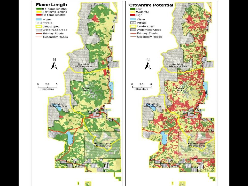
Fire Behavior Potential Used extreme (95t h percentile) weather conditions Used extreme (95t h percentile) weather conditions Created fuel model and slope class layers Created fuel model and slope class layers Ran BEHAVE and populated coverage Ran BEHAVE and populated coverage Used flame length to rate low (0-4 ft), moderate (5-8 ft) or high (> 8 ft) fire behavior risk Used flame length to rate low (0-4 ft), moderate (5-8 ft) or high (> 8 ft) fire behavior risk Calculated crown fire potential using flame length and seral stage/PNVG designations Calculated crown fire potential using flame length and seral stage/PNVG designations Surface fire------Crown fire
 weather conditions Used extreme (95t h percentile) weather conditions Created fuel model and slope class layers Created fuel model and slope class layers Ran BEHAVE and populated coverage Ran BEHAVE and populated coverage Used flame length to rate low (0-4 ft), moderate (5-8 ft) or high (> 8 ft) fire behavior risk Used flame length to rate low (0-4 ft), moderate (5-8 ft) or high (> 8 ft) fire behavior risk Calculated crown fire potential using flame length and seral stage/PNVG designations Calculated crown fire potential using flame length and seral stage/PNVG designations Surface fire------Crown fire")
27
Other Issues Wildland urban interface Wildland urban interface Bald eagle land management unit Bald eagle land management unit Spotted owl nests Spotted owl nests Late successional reserves Late successional reserves Spotted owl core sites outside of LSRs Spotted owl core sites outside of LSRs Fish (sucker and bull trout) habitat Fish (sucker and bull trout) habitat
 habitat Fish (sucker and bull trout) habitat")
28
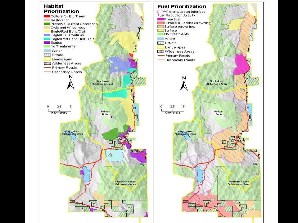
Create Priority Areas Wildlife Fuels/fire Multi-Resource

32
Treat Priority Areas FRCC identifies amount seral stages area deviating from reference conditons (WHAT) FRCC identifies amount seral stages area deviating from reference conditons (WHAT) Current fire risk identifies key “hot spots” from ignition and fire behavior risk (WHERE) Current fire risk identifies key “hot spots” from ignition and fire behavior risk (WHERE) Other issues help determine WHERE and HOW to treat landscape Other issues help determine WHERE and HOW to treat landscape
 FRCC identifies amount seral stages area deviating from reference conditons (WHAT) Current fire risk identifies key hot spots from ignition and fire behavior risk (WHERE) Current fire risk identifies key hot spots from ignition and fire behavior risk (WHERE) Other issues help determine WHERE and HOW to treat landscape Other issues help determine WHERE and HOW to treat landscape")
33
Next Steps 1. Determine schedule for treating high priority blocks 2. Begin NEPA process Use information from FRCC to guide how much and what kinds of stands to treat Use information from FRCC to guide how much and what kinds of stands to treat Run FARSITE/FLANMAP to determine best placement of multi-resource treatments Run FARSITE/FLANMAP to determine best placement of multi-resource treatments

Similar presentations


 project update and discussion.>")


