Download presentation
Presentation is loading. Please wait.

1
Regional Oceanography I
OEAS 604 Lecture Outline Arctic circulation Atlantic basin circulation Indian Ocean circulation Chapters 8,9 – Knauss Chapter 12 – Talley et al.

2
Two deep basins separated by sills Outlets to North Atlantic restricted to Norwegian Sea region Labrador Sea – water formation region at lower latitude

3
Primary Currents EGC, East Greenland Current EIC, East Iceland Current
IC, Irminger Current IFF, Iceland-Faroe Front JMC, Jan Mayen Current NAC, Norwegian Atlantic Current NIC, North Irminger Current Grey areas - polynyas

4
Overall schematic of (a) circulation, (b) water mass layers and transformation sites, and (c) water masses in potential temperature-salinity. EGC, East Greenland Current; WSC, West Spitsbergen Current. AW, Atlantic Water; AIW, Arctic Intermediate Water; ASW, Arctic Surface Water; DW, Deep Water; PIW, Polar Intermediate Water; PW, Polar Water. Convective Chimneys – water formation regions

5
Deep Water Formation Regions

6
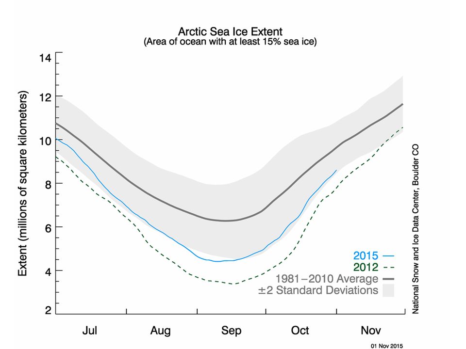
Summer minimum Winter maximum

10
(a) Potential temperature (°C) and (b) salinity in the Fram Strait.
 Potential temperature (°C) and (b) salinity in the Fram Strait.")
11
(a) Potential temperature (°C) and (b) salinity across the southern Greenland Sea at 73.5°N.
 Potential temperature (°C) and (b) salinity across the southern Greenland Sea at 73.5°N.")
12
Arctic Ocean: (a) Potential temperature and (b) salinity profiles for the Canadian (dashed) and Eurasian Basins (solid).. (c) Expanded potential temperature and salinity profile in the Canadian Basin
 Expanded potential temperature and salinity profile in the Canadian Basin.")
13
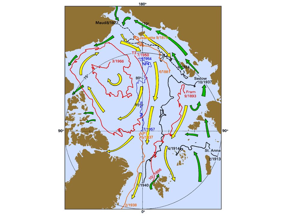
(a) Track of the Fram (1893-1896)
(a) Track of the Fram ( ). (b) The ship was intentionally frozen into the ice in 1893 and drifted with the pack until © Source: From Frammuseet (2003).
 Track of the Fram ( ). (b) The ship was intentionally frozen into the ice in 1893 and drifted with the pack until © Source: From Frammuseet (2003).")
15
East and west basins separated by Mid-Atlantic Ridge Connection to Arctic and Southern Ocean NADW formation in Greenland, Norwegian and Labrador Seas

16
Antarctic Bottom Water
Pathways Different varieties along western and eastern sides of basin Limited across basin exchange Flow on eastern side blocked by Walvis Ridge

17
AAIW Depth of Minimum Salinity

18
Atlantic Ocean Current Structure
Subtropical gyres in both hemispheres Eastern and western boundary currents Subpolar gyre in northern hemisphere Equatorial current system Connection to Arctic Connection to Southern Ocean

19
Western Boundary Currents
Gulf Stream, Brazil Current Eastern Boundary Currents Canary Current, Benguela Current Equatorial Current System North Equatorial Current Equatorial Countercurrent South Equatorial Current Subpolar Gyre North Atlantic Current Irminger Current East and West Greenland Currents Labrador Current

20
Gulf Stream Deep current High velocity High transport Brazil Current

21
Gulf Stream Variability
Branches – North Atlantic Current, Azores Current Sargasso Sea

22
Gulf Stream rings Warm core ring Cold core rings Cold core ring location

23
Gulf of Mexico Loop Current – spin off eddies

24
Canary Current – eastern boundary current
Shallower Lower velocity Upwelling

25
Mediterranean Outflow
Temperature at 1000 m Salinity at 1000 m

26
Mediterranean Sea Bathymetry

27
Currents – Mediterranean

28
Water Masses - Mediterranean
LIW - Levantine Intermediate Water

29
Temperature section across
Equator in Atlantic Ocean

30
South Atlantic Current System

31
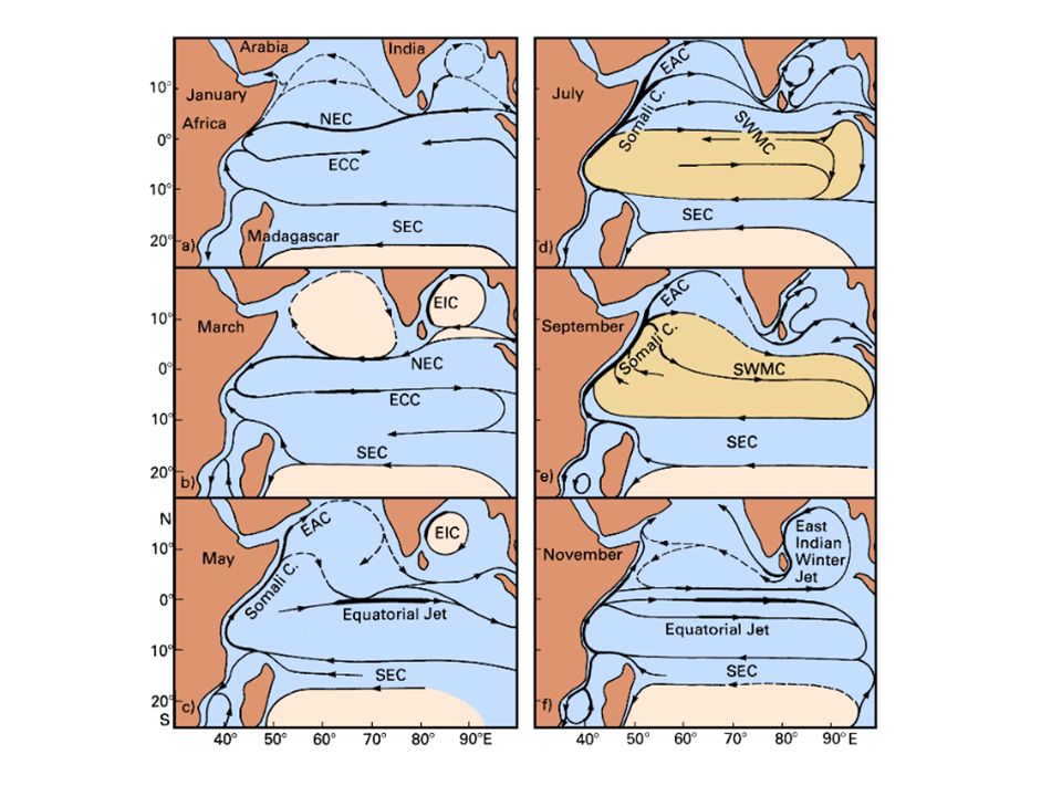
Indian Ocean Blocked to north Wind patterns change direction with season (monsoon) Circulation in northern Indian Ocean changes direction every six months

32
January – Mean Wind Field

33
Northeast Monsoon Northern winter (Dec-Feb) cooling of Siberia and Central Asia land mass – greater than cooling of ocean Atmospheric high pressure forms over land and develops polar continental air mass that sets up pressure gradient that directs winds from land towards sea – cold dry air Over Africa have trans-equatorial meridional atmospheric pressure gradient (high north, low south) that directs wind into Indian Ocean Blocks the southward extent of NE monsoon – usually does not cross about 10°S
 that directs wind into Indian Ocean. Blocks the southward extent of NE monsoon – usually does not cross about 10°S.")
34
July – Mean Wind Field

35
Southwest Monsoon Northern summer (June-Aug) warming of southern Eurasia and North Africa land mass Atmospheric low pressure forms that directs winds from sea to land – pick up moisture Strong southwest winds blow over the Arabian Sea and Ba of Bengal carrying considerable water vapor – produces the summer rains

36
Indian Ocean – Monsoon System

37
Northeast Monsoon Southwest Monsoon

39
Agulhas Current Western boundary current

40
Leeuwin Current – eastern boundary current

41
Australian Mediterranean Sea

42
Australian Mediterranean Sea
February August

43
Next Class Continue Currents and Water Masses
Pacific Ocean – Chapter 10, Talley et al. Ocean-atmosphere coupling, Climate change – Chapter 14, Talley et al.

Similar presentations


>")


