Download presentation
Presentation is loading. Please wait.

1
Airborne Studies of Atmospheric Dynamics
Thomas R. Parish Department of Atmospheric Science University of Wyoming

2
Newton’s Second Law – The Equation of Motion
Total Derivative Local Derivative Advection (Inertia) Term Horizontal Pressure Gradient Force Coriolis Force Geostrophic component Ageostrophic component
 Term. Horizontal Pressure. Gradient Force. Coriolis Force. Geostrophic. component. Ageostrophic. component.")
3
Purely rotational (non-divergent) Often the largest component of wind
Geostrophic Wind Balanced flow state Purely rotational (non-divergent) Often the largest component of wind Relatively inert component of the wind Vg L H P C
 Often the largest component of wind. Relatively inert component of the wind. Vg. L. H. P. C.")
4
Ageostrophic Wind Unbalanced flow state Often contains significant divergent component Generally small component of wind Isallobaric and inertia/advective components generally largest Important forcing component of the wind

5
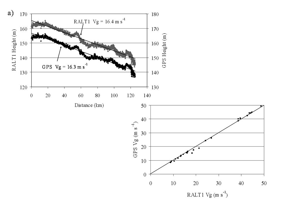
Measurement of Geostrophic Wind
Write Equation of Motion in isobaric coordinates Variation of height on a pressure surface proportional to horizontal pressure gradient force Airborne applications – use autopilot

6
Pre-GPS Era (before 2004) Radar Altimeter measurements provide height above surface Terrain maps (digital) provide terrain height assuming geographic position known with high accuracy Height of isobaric surface is sum of above signals
 provide terrain height assuming geographic position known with high accuracy. Height of isobaric surface is sum of above signals.")
7
Problems: Two signals (radar altimeter heights, terrain height) large and of opposite sign PGF is the sum of those terms, being quite small and noisy Potential errors in both radar altimeter height, terrain height “Artifact” problem for radar altimeter Footprint issue for altimeter Uncertainties in aircraft position estimates Issues with terrain height data sets Resulting uncertainty with “terrain registration”

8
Example: Great Plains Low-Level Jet
Nocturnal summertime jet maximum ~400 m agl Competing theories for LLJ formation Blackadar frictional decoupling Holton sloping terrain influence

12
Results of PGF measurements at lowest level
Flight Strategy – Repeating isobaric legs

13
Conclusions: Isallobaric component of wind ~4 m/s at level maximum wind Large changes in turbulent intensity at jet level Blackadar frictional decoupling dominant mechanism in forcing Great Plains LLJ

14
GPS Era Avoid “terrain registration” issues GPS provides a means to accurately map isobaric surface Position errors from standard GPS receiver insufficient to resolve isobaric slopes Differential GPS required Requires fixed base station Position errors at base station can be used to correct position errors for rover platform (aircraft) Importance of acceptable satellite constellation (5 or 6?) Position accuracy on order of decimeters Relative accuracy probably much better
 Importance of acceptable satellite constellation (5 or 6 ) Position accuracy on order of decimeters. Relative accuracy probably much better.")
15
GPS04 Study – Arcata CA Frequent summertime LLJ at top of marine boundary layer Comparison with altimetry-derived geostrophic wind Tested GrafNav differential processing software

16
GPS04 LLJ Example Isobaric east-west flight leg south of Cape Mendocino Nearly identical signals dGPS calculations of Vg from most legs within 1 m/s altimetry Vg GPS04 validated dGPS technique

18
Application of dGPS on atmospheric dynamics – Coastally Trapped Wind Reversals (CTWRs, also CTDs, southerly surges) 0000 UTC 22 June UTC 26 June 2006

19
CTWR Forcing Issues Kelvin Wave Cross-coast PGF
Variations in MBL Height Topographic Rossby Wave Topographically-Trapped Wave Density Current Synoptic-scale response Ageostrophic acceleration Importance of synoptic-scale pressure field

20
23 June 2006 Example Isobaric east-west flight leg Little detectable cross-coast PGF

21
23 June 2006 Example

22
23 June 2006 Example

23
23 June 2006 Example

24
24 June 2006 Example

25
24 June 2006 Example

26
23-25 June 2006 CTWR Conclusions
CTWR density current No Kelvin-wave features observed during this event Active propagation phase highly ageostrophic Little detectable cross-coast PGF at any time during the life history Onset and propagation dependent on synoptic pressure field

27
Application: CloudGPS08
May-June 2008, flights over high plains WY, NE, CO Measure horizontal perturbation pressures associated with clouds Clouds mostly in cumulus congestus phase Differential GPS dependent on accurate measurement of static pressure

28
Application: CloudGPS08 (May 21)
")
29
θV Isobaric Height Liquid Water Content (g/kg) u W (m/s) v
Horizontal Pressure Perturbation (mb) θV
 θV.")
30
Liquid Water Content (g/kg) W (m/s) Horizontal Pressure Perturbation (mb)
 W (m/s) Horizontal Pressure Perturbation (mb)")
31
Application: CloudGPS08 (June 17)
")
32
Leg 1 θV Liquid Water Content (g/kg) Isobaric Height W (m/s) u v
Horizontal Pressure Perturbation (mb) θV
 θV.")
33
Leg 2 θV Liquid Water Content (g/kg) Isobaric Height W (m/s) u v
Horizontal Pressure Perturbation (mb) θV
 θV.")
34
Leg 3 θV Liquid Water Content (g/kg) Isobaric Height W (m/s) u v
Horizontal Pressure Perturbation (mb) θV
 θV.")
35
Leg 4 θV Liquid Water Content (g/kg) Isobaric Height W (m/s) u v
Horizontal Pressure Perturbation (mb) θV
 θV.")
36
Leg 5 θV Liquid Water Content (g/kg) Isobaric Height W (m/s) u v
Horizontal Pressure Perturbation (mb) θV
 θV.")
37
Leg 1

38
Leg 2

39
Leg 3

40
Leg 4

41
Leg 5

42
Application: Ocean Surface Topography
Differences between GPS height, radar altimeter signal measure of ocean surface topography

43
Application: Ocean Surface Topography
Reciprocal legs along 40.8°N Consistent pattern of height differences Validate using multiple altimeters? Gulf Stream flights?

44
Application: Ocean Surface Topography
Reciprocal legs along 40.8°N Consistent pattern of height differences Validate using multiple altimeters? Gulf Stream flights?

45
Application: Ocean Surface
Topography

46
dGPS can provide precise mapping of aircraft height
Conclusions dGPS can provide precise mapping of aircraft height Base station data rate 1 Hz Baseline ~ 100 km? dGPS accuracy within decimeters? Relative accuracy higher? Accurate measurement of static pressure permits PGF calculations Assessment of atmospheric dynamics for a wide variety of flows Thanks to Dave Leon, Larry Oolman, Dave Rahn and Eric Parish

Similar presentations


 What is this??? Go to: www.mmm.ucar.edu/imagearchive and pull up:www.mmm.ucar.edu/imagearchive.>")


 Geostrophic wind blows parallel to.>")


 Last week, we learned that we could estimate a derivative quantity using finite.>")


 we’ve covered a number of concepts from Ch4 already… next: scales of motion pressure gradient force Coriolis.>")
