Download presentation
Presentation is loading. Please wait.

1
AOSC 200 Lesson 6

2
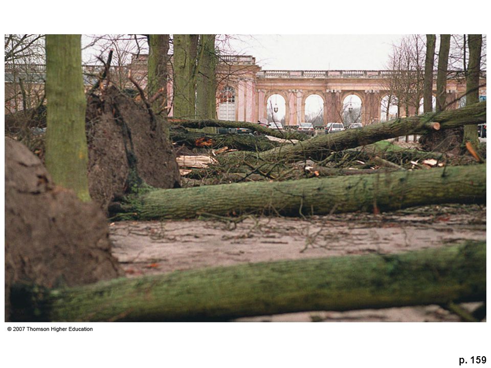
p. 159

4
Fig. 6.3

5
Newton’s Laws First Law (Law of Inertia): A body at rest tends to stay at rest while a body in motion tends to stay in motion, traveling at a constant speed and in a straight line, until acted upon by an outside force
: A body at rest tends to stay at rest while a body in motion tends to stay in motion, traveling at a constant speed and in a straight line, until acted upon by an outside force")
6
Newton’s Laws Second Law (Law of Momentum): A force exerted on an object (including a parcel of water or gas) of a given mass causes the object to accelerate in the direction of the applied force and in proportion to the force divided by the objects mass. Force equals Mass times Acceleration

7
Fig. 6-2, p. 160

8
Fig. 6.2

9
Box 6.1

11
Forces that Move the Air Gravitational force Is directed downward, normal to the ground Approximately equal to the mass of the air times the gravitational acceleration Pressure gradient force

12
Fig. 6-4, p. 161

13
Pressure Gradient Force

14
PRESSURE- GRADIENT FORCE IS A FUNCTION OF THE PRESSURE DIFFERENCE AND AIR DENSITY. F PC = ΔP / D.σ WHERE F PC = PRESSURE GRADIENT FORCE PER UNIT MASS σ = DENSITY OF AIR ΔP = PRESSURE DIFFERENCE BETWEEN TWO POINTS D = DISTANCE BETWEEN THE TWO POINTS.NEWTON’S LAW STATES FORCE=MASS TIMES ACCELERATION F PC IS A FORCE PER UNIT MASS, I.E. IS EQUIVALENT TO ACCELERATION

15
Apparent Forces in the Atmosphere Coriolis Force Centrifugal Force/Centripetal acceleration

16
Coriolis Effect

17
Fig. 6-9, p. 165

18
Fig. 6-10, p. 167

19
CORIOLIS EFFECT WEATHER MAP SHOWS THAT WINDS GO AROUND A LOW PRESSURE AREA, NOT ACROSS THE ISOBARS. THIS DEVIATION IS A RESULT OF THE EARTH'S ROTATION AND HAS BEEN NAMED THE CORIOLIS EFFECT (CORIOLIS FORCE) THIS FORCE ALWAYS ACTS AT RIGHT ANGLES TO THE DIRECTION OF MOTION.
 THIS FORCE ALWAYS ACTS AT RIGHT ANGLES TO THE DIRECTION OF MOTION..")
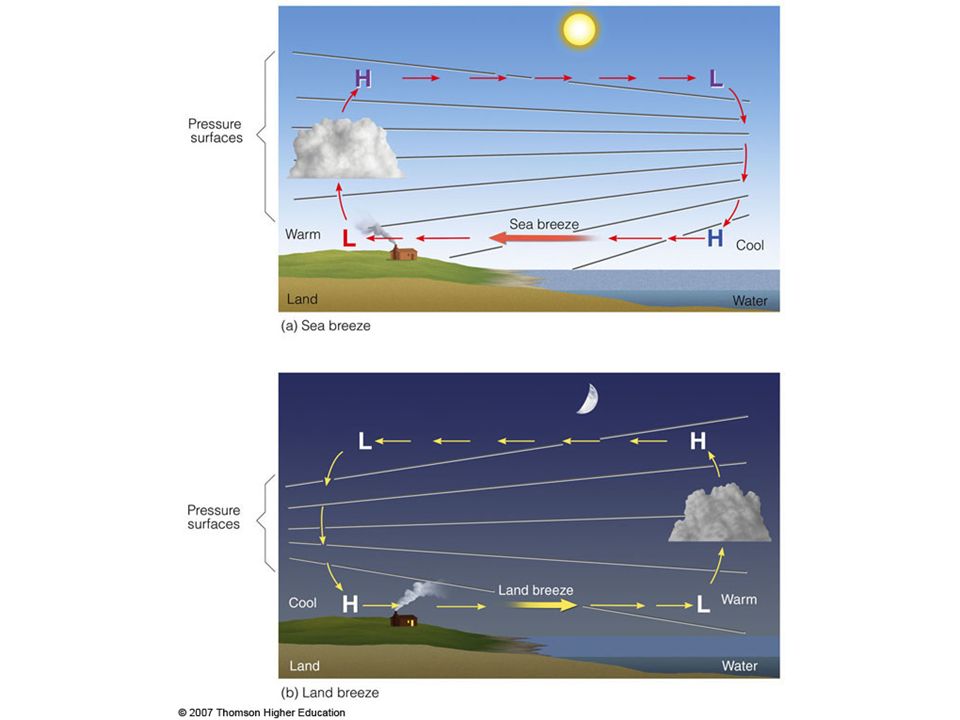
20
A popular misconception

21
Fig. 6.11 Centrifugal Force

22
The Mechanism for Geostrophic Flow

23
GEOSTROPHIC FLOW EVENTUALLY A BALANCE IS REACHED BETWEEN THE CORIOLIS FORCE AND THE PRESSURE GRADIENT FORCE IF THERE IS NO FRICTION THEN THIS OCCURS WHEN THE PARCEL OF AIR IS PARALLEL TO THE ISOBARS. AT THIS POINT THERE IS NO NET FORCE ON THE AIR PARCEL - NO ACCELERATION - IT NOW MOVES WITH CONSTANT VELOCITY. UNDER THESE IDEALIZED CONDITIONS THE AIRFLOW IS SAID TO BE IN GEOSTROPHIC BALANCE. WIND GENERATED IS CALLED THE GEOSTROPHIC WIND NORMALLY ONLY APPLIES TO WINDS ALOFT. SURFACE WINDS ARE SUBJECT TO FRICTION.

24
Fig. 6-15, p. 172

25
GRADIENT WINDS WINDS AROUND CENTERS OF HIGH OR LOW PRESSURE FOLLOW CURVED PATHS IN ORDER TO STAY PARALLEL WITH THE ISOBARS. THESE WINDS ARE CALLED GRADIENT WINDS. LOW PRESSURE CENTERS ARE CALLED CYCLONES - ROTATION IS COUNTER-CLOCKWISE - SAME AS THE EARTH CENTERS OF HIGH PRESSURE ARE CALLED ANTI- CYCLONES. IN SOUTHERN HEMISPHERE THE DIRECTIONS OF FLOW ARE REVERSED

26
Fig. 6-12, p. 168

27
Fig. 6-18, p. 175

29
Fig. 6-24, p. 181

30
SURFACE WINDS FRICTION AFFECTS WINDS ONLY CLOSE TO THE EARTH'S SURFACE. NOW WE MUST BALANCE THREE FORCES - CORIOLIS, PRESSURE GRADIENT AND FRICTION. NET EFFECT IS TO INDUCE A NET INFLOW AROUND A CYCLONE, AN EFFECT KNOWN AS CONVERGENCE. AROUND AN ANTICYCLONE WE GET A NET OUTFLOW, DIVERGENCE

31
Aneroid Barometer

32
On an aneroid barometer fair corresponds to high surface pressure. Air is subsiding and is subject to adiabatic heating. This lowers the relative humidity. Hence possibility of clouds forming is low. Rain corresponds to low pressure. Air is rising and is subject to adiabatic cooling. The raises the relative humidity. Possibility of clouds is high.

35
Effect of temperature on pressure Initially the pressure above each city is the same. But if we heat the air above one of them the column of air will expand. If we cool the air above the other it will contract. If we now look at the pressure at the top pf the cool air it will be lower than that in the heated column. This is because pressure is defined as the weight of air above a given altitude. The weight of air above the cold column is less than that at the same altitude in the not column This will cause air to move from the hot column to the cold column. Hence the pressure will increase in the cold column at the ground, and the pressure will decrease in the hot column.

36
Fig. 6-22, p. 179

38
SEA BREEZES ARE THE RESULT OF DIFFEERENTIAL HEATING OF THE OCEAN AND THE LAND DURING THE DAY THE LAND HEATS UP QUICKLY WHILE THE OCEAN HEATS UP SLOWLY HIGH TEMPERATURE OVER THE LAND, LOWER TEMPERATURE OVER THE OCEAN AT THE SURFACE - HIGH PRESSURE OVER THE OCEAN, LOW PRESSURE OVER THE LAND - CAUSES WIND AT THE SURFACE TO FLOW FROM THE OCEAN TO THE LAND (SEA BREEZE) AT NIGHT THE LAND COOLS RAPIDLY TO A TEMPERAURE BELOW THAT OF THE OCEAN. WIND REVERSES - FLOWS FROM THE LAND TO THE OCEAN AT THE SURFACE (LAND BREEZE)
.")
39
Fig. 7-6, p. 175 Stepped Art

40
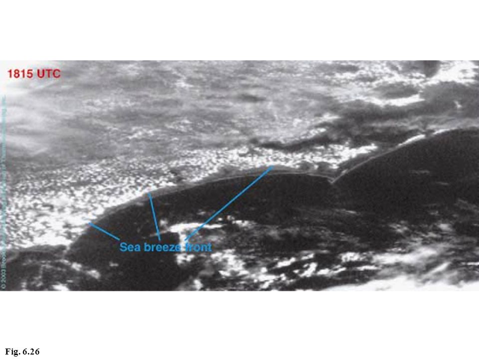
Fig. 6.26

Similar presentations


>")


