Download presentation
Presentation is loading. Please wait.

1
V:\corporate\marketing\overview.ppt GRGAQS: Meteorological Modeling Presentation to the SWCAA By ENVIRON International Corporation Alpine Geophysis, LLC August 8, 2006

2
V:\corporate\marketing\overview.ppt Today’s Presentation Further evaluation of MM5 performance Analyses conducted for August and November modeling episodes: –4-km surface wind fields in Gorge area –Cloud cover and fog on 4-km grid Compare to satellite and Wishram camera –Wind, temperature, RH at Wishram

3
V:\corporate\marketing\overview.ppt

6
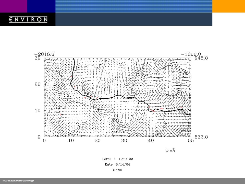
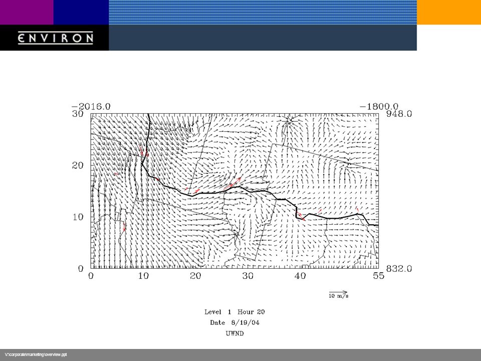
Wind Performance, August 2004 Hi b scat 8/10-8/16, 8/19 Poor performance at central sites 8/10-8/13 –Wind opposite direction Good performance 8/14-8/22 –Maybe too light on some days

7
V:\corporate\marketing\overview.ppt

10
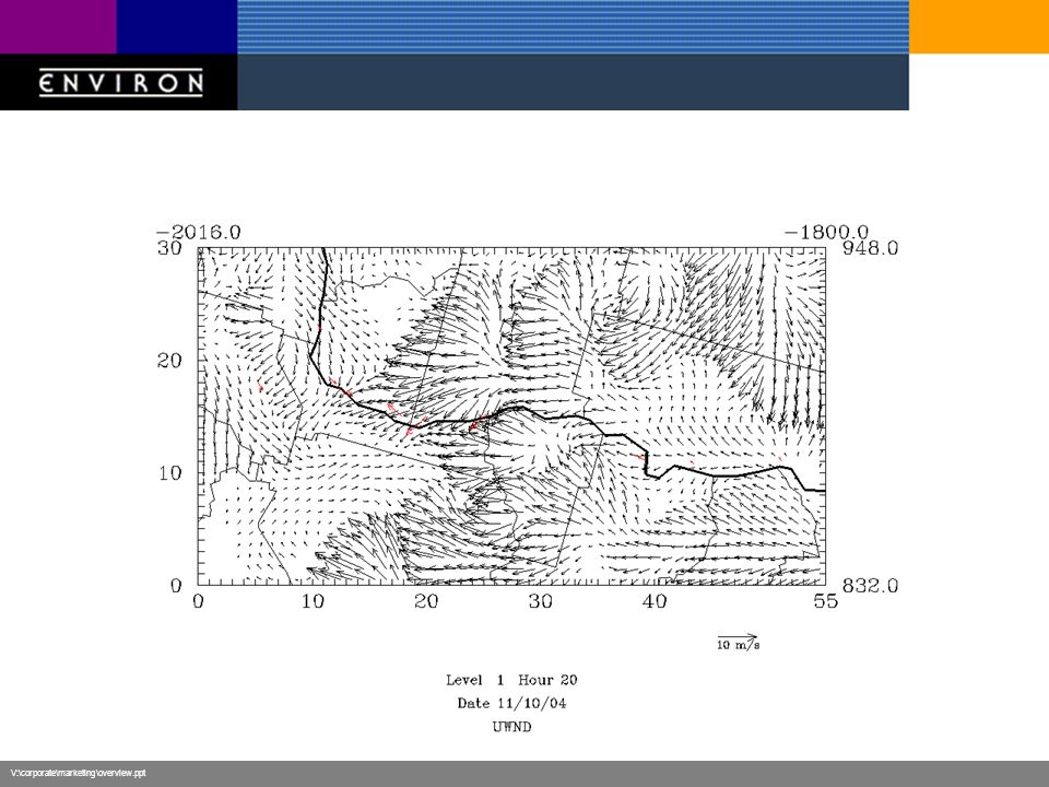
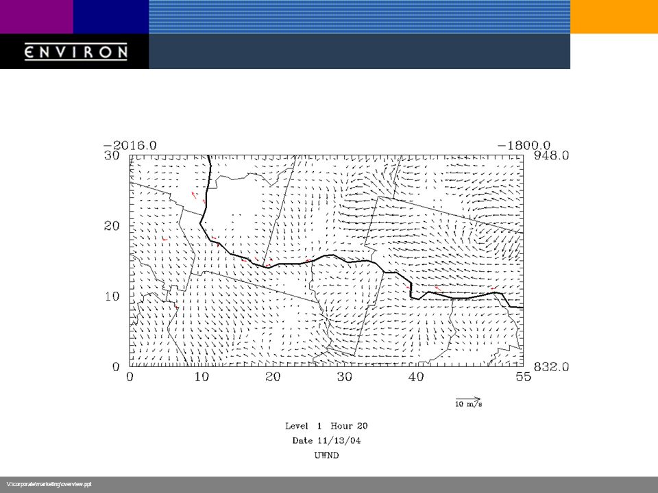
Wind Performance, November 2004 Hi b scat 11/8-11/13 Overall better performance than for August episode Very good performance over 11/8- 11/13 –Some stagnation leads to wind direction errors –Some windy periods are too light

11
V:\corporate\marketing\overview.ppt Cloud Cover August 2004 notes at Wishram camera: 8/10 Scattered clouds < half of sky, No layered haze 8/11 No clouds, No layered haze 8/12 Scattered clouds < half of sky, No layered haze 8/13 No clouds, No layered haze 8/14 (high) Overcast > half of sky, No layered haze 8/15 Scattered clouds < half of sky, No layered haze 8/16 (high thin) Overcast > half of sky, No layered haze 8/17 (high thin) Overcast > half of sky, No layered haze 8/18 (high thin) Overcast > half of sky, No layered haze 8/19 Scattered clouds < half of sky, No layered haze 8/20 (high thin) Overcast > half of sky, No layered haze 8/21 (high) Overcast > half of sky, No layered haze 8/22 Overcast > half of sky, No layered haze
 Overcast > half of sky, No layered haze 8/15 Scattered clouds < half of sky, No layered haze 8/16 (high thin) Overcast > half of sky, No layered haze 8/17 (high thin) Overcast > half of sky, No layered haze 8/18 (high thin) Overcast > half of sky, No layered haze 8/19 Scattered clouds < half of sky, No layered haze 8/20 (high thin) Overcast > half of sky, No layered haze 8/21 (high) Overcast > half of sky, No layered haze 8/22 Overcast > half of sky, No layered haze")
12
V:\corporate\marketing\overview.ppt Wishram Camera August 13, noonPristine

13
V:\corporate\marketing\overview.ppt

14
Wishram Camera August 14, noonPristine

15
V:\corporate\marketing\overview.ppt

16
Wishram Camera August 19, noonPristine

17
V:\corporate\marketing\overview.ppt

18
August 2004 Cloud Cover Performance appears adequate –MM5 cannot replicate high thin/wispy cirrus –MM5 usually underperforms for scattered small-scale afternoon cumulus –These should not play significant role in regional PM chemistry

19
V:\corporate\marketing\overview.ppt Cloud Cover November 2004 notes at Wishram camera: 11/3 Scattered clouds < half of sky, No layered haze 11/4 No clouds, Ground-based layered haze only 11/5 (high thin) Overcast > half of sky, No layered haze (hazy) 11/6 Scattered clouds < half of sky, Ground-based layered haze only 11/7 Overcast > half of sky, No layered haze (hazy) 11/8 Overcast > half of sky, Weather concealing scene (thick haze) 11/9 Overcast > half of sky, Weather concealing scene (thick haze) 11/10 Overcast > half of sky, Weather concealing scene (fog) 11/11 Overcast > half of sky, Weather concealing scene (thick haze) 11/12 Overcast > half of sky, Weather concealing scene (fog) 11/13 Overcast > half of sky, Weather concealing scene (thick haze) 11/14 Overcast > half of sky, Weather concealing scene (distant fog) 11/15 Overcast > half of sky, Weather concealing scene 11/16 Overcast > half of sky, No layered haze 11/17 Scattered clouds < half of sky, No layered haze 11/18 Overcast > half of sky, No layered haze
 Overcast > half of sky, No layered haze (hazy) 11/6 Scattered clouds < half of sky, Ground-based layered haze only 11/7 Overcast > half of sky, No layered haze (hazy) 11/8 Overcast > half of sky, Weather concealing scene (thick haze) 11/9 Overcast > half of sky, Weather concealing scene (thick haze) 11/10 Overcast > half of sky, Weather concealing scene (fog) 11/11 Overcast > half of sky, Weather concealing scene (thick haze) 11/12 Overcast > half of sky, Weather concealing scene (fog) 11/13 Overcast > half of sky, Weather concealing scene (thick haze) 11/14 Overcast > half of sky, Weather concealing scene (distant fog) 11/15 Overcast > half of sky, Weather concealing scene 11/16 Overcast > half of sky, No layered haze 11/17 Scattered clouds < half of sky, No layered haze 11/18 Overcast > half of sky, No layered haze")
20
V:\corporate\marketing\overview.ppt Wishram Camera November 6, noonPristine

21
V:\corporate\marketing\overview.ppt

22
Wishram Camera November 8, noonPristine

23
V:\corporate\marketing\overview.ppt

24
Wishram Camera November 10, noonPristine

25
V:\corporate\marketing\overview.ppt

26
Wishram Camera November 15, noonPristine

27
V:\corporate\marketing\overview.ppt

28
November 2004 Cloud Cover Large-scale higher clouds appear well simulated Low-level cloud/fog events are not –Especially on the high b scat days –This will impact aqueous PM chemistry –This would impact b scat reconstruction If we use MM5-predicted humidity EPA method: use measured humidity

29
V:\corporate\marketing\overview.ppt Wishram Meteorology

30
V:\corporate\marketing\overview.ppt Wishram Meteorology

31
V:\corporate\marketing\overview.ppt Wishram Meteorology

32
V:\corporate\marketing\overview.ppt Wishram Meteorology

33
V:\corporate\marketing\overview.ppt August 2004 Meteorology Wind speed/direction well simulated –Terrain channeling may be leading to higher observed speeds and direction bias Temperatures on 4-km grid are highly suspect –RH performance follows poor temperature performance –Need to investigate further Could use in some initial PM modeling

34
V:\corporate\marketing\overview.ppt Wishram Meteorology

35
V:\corporate\marketing\overview.ppt Wishram Meteorology

36
V:\corporate\marketing\overview.ppt Wishram Meteorology

37
V:\corporate\marketing\overview.ppt Wishram Meteorology

38
V:\corporate\marketing\overview.ppt November 2004 Meteorology Wind speed/direction performance appears acceptable Temperature performance is poor –Need to investigate cause RH is too low – no fog – not associated with temperature problem This episode is currently not useable

Similar presentations