Download presentation
Presentation is loading. Please wait.

1
THE EFFECTS OF SPECIFIC CONDUCTANCE OF WATER ON THE BENTHIC MACROINVERTEBRATE COMMUNITY DOWNSTREAM OF COAL MINING ACTIVITIES __________________________________ R.R. Maggard

2
Downstream effects of mountaintop coal mining: comparing biological conditions using family- and genus-level macroinvertebrate bioassessment tools ______________________________________________________________________ Gregory J. Pond 1, Margaret E. Passmore 2, Frank A. Borsuk 3, Lou Reynolds 4, AND Carole J. Rose 5 Region 3, US Environmental Protection Agency, 1060 Chapline Street, Wheeling, West Virginia 26003 USA J. N. Am. Benthol. Soc., 2008, 27(3):717–737 ©2008 by The North American Benthological Society DOI: 10.1899/08-015.1 Published online: 8 July 2008
:717–737 ©2008 by The North American Benthological Society DOI: / Published online: 8 July")
3
ABSTRACT _______________________________________________ Regulatory agencies have been attempting to blame Mountaintop Coal Mining and the associated valley fills for impairment of streams by narrative water quality standards –Trying to connect moderate (500 µs/cm) to high (1000 µs/cm) specific conductance to impairment of benthic macroinvertebrate communities Not enough information to draw conclusions This Study conducted in Southern West Virginia in four (4) adjacent watersheds –Results conflict with Pond et al. 2008 Specific conductivity unrelated to benthic macroinvertebrate communities

4
INTRODUCTION _________________________________________ Pond et al. 2008: –Categorized mining impacts based on specific conductivity in relation to SO 4 concentrations 1.Low < 500 µs/cm 2.Medium 500-1000 µs/cm 3.High > 1000 µs/cm –“Within the mined site data set, we found no evidence that MMI’s (multimetric indices) were significantly correlated with the number of valley fills upstream or distance from the fill (p>0.05), but these indicators appeared to be related to our inexact estimates of the amount of mining in the watershed.”
 were significantly correlated with the number of valley fills upstream or distance from the fill (p>0.05), but these indicators appeared to be related to our inexact estimates of the amount of mining in the watershed. .")
5
INTRODUCTION (cont’d) _______________________________________ This study is based on exact information –The exact degree and age of mining-related disturbance in the watershed –The exact stage of any reclamation in the watershed Estimation of mining related disturbance based upon predetermined specific conductance or sulfate values WILL NOT BE UTILIZED
 _______________________________________ This study is based on exact information –The exact degree and age of mining-related disturbance in the watershed –The exact stage of any reclamation in the watershed Estimation of mining related disturbance based upon predetermined specific conductance or sulfate values WILL NOT BE UTILIZED")
6
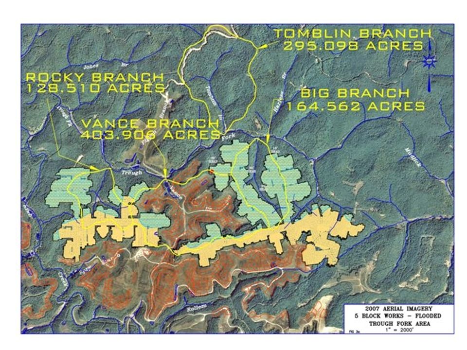
METHODOLOGY ___________________________________________ Past studies have paid little attention to the type of mining occurring, the targeted seam being mined, size and stage of construction of valley fills, and reclamation status This study analyzes in detail: –Land uses that may contribute to elevated conductivities Investigate relationship between land use and conductivity –Data collected in four (4) adjacent watersheds located in Southern West Virginia Near Kiahsville in Wayne County on tributaries of Trough Fork
 adjacent watersheds located in Southern West Virginia Near Kiahsville in Wayne County on tributaries of Trough Fork")
10
SITE DESCRIPTIONS: BIG BRANCH ______________________________________________ Watershed: 165 ACRES Surface disturbance: NEGLIGIBLE Discharge: HIGH CONDUCTIVITY WATER Source: INDISCRETE SEEPAGE THROUGH A 200-FOOT- WIDE OUTCROP BARRIER AS A RESULT OF A FLOODED UNDERGROUND MINE –Mine was sealed in 2000 –Targeted the 5-Block coal seam Allows for evaluation of water chemistry changes in absence of sediment pond construction, valley fill construction, and other misc. land clearing activities

11
SITE DESCRIPTIONS: TOMBLIN BRANCH ________________________________________ Watershed: 295 ACRES Surface disturbance: NEGLIGIBLE Discharge: LOW CONDUCTIVITY WATER Source: REFERENCE STREAM (RECEIVES NO MINING-RELATED DISCHARGES) –Located across the hollow from Big Branch Selected as a reference site
 –Located across the hollow from Big Branch Selected as a reference site")
12
SITE DESCRIPTIONS: ROCKY BRANCH ______________________________________________ Watershed: 129 ACRES Surface disturbance: NEGLIGIBLE Discharge: HIGH CONDUCTIVITY WATER Source: SEEPAGE ON THE DOWN-DIP OUTCROP CONTRIBUTING TO BASE FLOW AS A RESULT OF A FLOODED UNDERGROUND MINE –Mine sealed in 2001 –Targeted the 5-Block coal seam Selected for its similarity to Big Branch

13
SITE DESCRIPTIONS: VANCE BRANCH ______________________________________________ Watershed: 404 ACRES Surface disturbance: PREVIOUS DISTURBANCE OF 275 ACRES Discharge: HIGH CONDUCTIVITY WATER Source: TYPICAL SURFACE MINE WITH TWO (2) VALLEY FILLS AND FOUR (4) SEDIMENT PONDS –Surface Mine has been reclaimed since 2000 –Targeted the 5-Block coal seam Selected to represent surface disturbance due to surface mining
 VALLEY FILLS AND FOUR (4) SEDIMENT PONDS –Surface Mine has been reclaimed since 2000 –Targeted the 5-Block coal seam Selected to represent surface disturbance due to surface mining")
14
METHODS OF INVESTIGATION _____________________________________________ All 4 sites evaluated for benthic macroinvertebrates, aquatic habitat, and water chemistry –Modified EPA/620/R-94/004F and EPA 841-B-99-002 were followed Five (5) sampling events have been conducted for Big Branch and Tomblin Branch sites: –Fall 2007, Spring 2008, Summer 2008, Fall 2008, and Winter 2009 Two (2) sampling events have been conducted for Rocky Branch and Vance Branch sites: –Fall 2008 and Winter 2009
 sampling events have been conducted for Big Branch and Tomblin Branch sites: –Fall 2007, Spring 2008, Summer 2008, Fall 2008, and Winter 2009 Two (2) sampling events have been conducted for Rocky Branch and Vance Branch sites: –Fall 2008 and Winter 2009")
15
METHODS OF INVESTIGATION (cont’d) ---------------------------------------------------- Parameters evaluated for each site: –Water chemistry –Physical water quality –Habitat assessment –Benthic macroinvertebrate collection –Benthic macroinvertebrate metrics
 Parameters evaluated for each site: –Water chemistry –Physical water quality –Habitat assessment –Benthic macroinvertebrate collection –Benthic macroinvertebrate metrics")
16
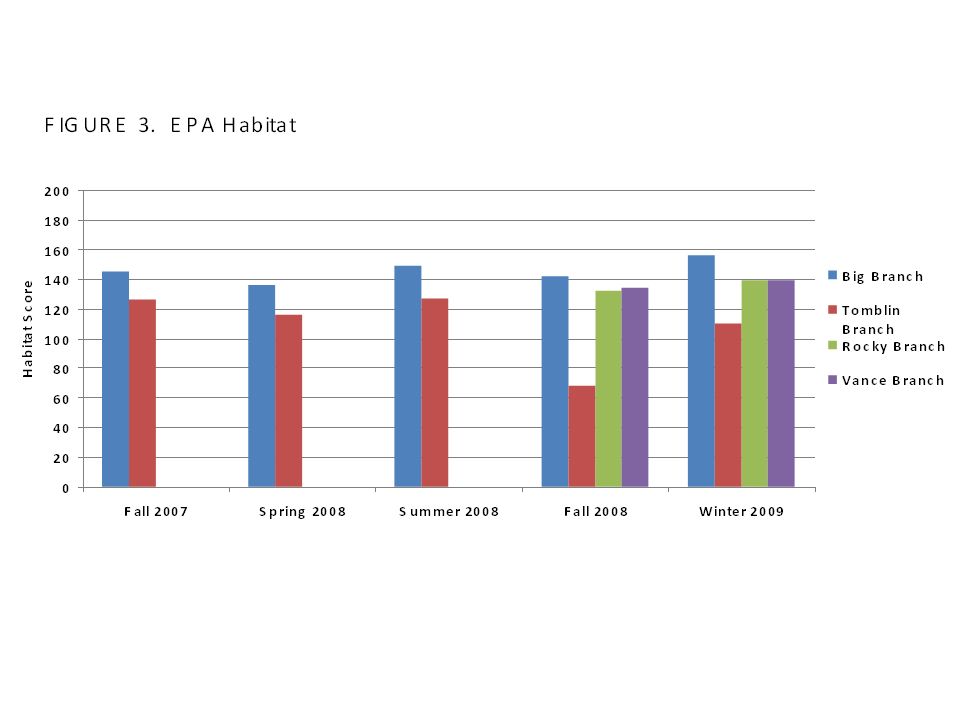
PHYSICAL DESCRIPTIONS AND HABITAT EVALUATIONS – BIG BRANCH _______________________________________________ BENTHIC SAMPLING LOCATION: 38° 02’ 24.9”, 82° 13’ 08.1” –Coarse Particulate Organic Matter (CPOM): moderate –Large Woody Debris (LWD): Sparse –SUBSTRATE: 5% sand, 75% gravel, 20% cobbles Sub-optimal to optimal aq. Habitat STREAM FLOW (ft 3 /s): 0.525 to 0.26 TEMPERATURE (°C): 0.2 to 18.8 pH: 7.09 to 7.77 DISSOLVED OXYGEN (DO in mg/l): 8.39 to 13.6 CONDUCTIVITY (µs): 543 to 1,550 HABITAT SCORE: 136 to 156 (mean = 146) suboptimal aquatic habitat
: to 0.26 TEMPERATURE (°C): 0.2 to 18.8 pH: 7.09 to 7.77 DISSOLVED OXYGEN (DO in mg/l): 8.39 to 13.6 CONDUCTIVITY (µs): 543 to 1,550 HABITAT SCORE: 136 to 156 (mean = 146) suboptimal aquatic habitat.")
17
PHYSICAL DESCRIPTIONS AND HABITAT EVALUATIONS – TOMBLIN BRANCH _______________________________________________ BENTHIC SAMPLING LOCATION: 38° 02’ 39.6”, 82° 13’ 28.6” –Coarse Particulate Organic Matter (CPOM): moderate –Large Woody Debris (LWD): Sparse –SUBSTRATE: 5% sand, 54% gravel, 40% cobbles, 1% boulder Sub-optimal to optimal aq. Habitat STREAM FLOW (ft 3 /s): No flow to 0.441 TEMPERATURE (°C): 0.7 to 21.2 pH: 5.93 to 6.72 DISSOLVED OXYGEN (DO in mg/l): 1.4 to 14.7 CONDUCTIVITY (µs): 49 to 470 HABITAT SCORE: 68 to 127 (mean = 109) marginal to suboptimal aquatic habitat
: No flow to TEMPERATURE (°C): 0.7 to 21.2 pH: 5.93 to 6.72 DISSOLVED OXYGEN (DO in mg/l): 1.4 to 14.7 CONDUCTIVITY (µs): 49 to 470 HABITAT SCORE: 68 to 127 (mean = 109) marginal to suboptimal aquatic habitat.")
18
PHYSICAL DESCRIPTIONS AND HABITAT EVALUATIONS – ROCKY BRANCH _______________________________________________ BENTHIC SAMPLING LOCATION: 38° 02’ 16.2”, 82° 14’ 37.3” –Coarse Particulate Organic Matter (CPOM): moderate –Large Woody Debris (LWD): moderate –SUBSTRATE: 15% sand, 15% gravel, 60% cobble, 10% boulder Sub-optimal to optimal aq. Habitat STREAM FLOW (ft 3 /s): 0.018 to 0.079 TEMPERATURE (°C): 0.2 to 10.8 pH: 7.58 to 6.45 DISSOLVED OXYGEN (DO in mg/l): 11.8 to 15.4 CONDUCTIVITY (µs): 663 to 1,650 HABITAT SCORE: 132 to 139, suboptimal aquatic habitat
: to TEMPERATURE (°C): 0.2 to 10.8 pH: 7.58 to 6.45 DISSOLVED OXYGEN (DO in mg/l): 11.8 to 15.4 CONDUCTIVITY (µs): 663 to 1,650 HABITAT SCORE: 132 to 139, suboptimal aquatic habitat.")
19
PHYSICAL DESCRIPTIONS AND HABITAT EVALUATIONS – VANCE BRANCH _______________________________________________ BENTHIC SAMPLING LOCATION: 38° 02’ 11.0”, 82° 14’ 03.1” –Coarse Particulate Organic Matter (CPOM): moderate –Large Woody Debris (LWD): moderate –SUBSTRATE: 1% sand, 19% gravel, 20% cobble, 60% boulder Sub-optimal to optimal aq. Habitat STREAM FLOW (ft 3 /s): 0.268 to 1.331 TEMPERATURE (°C): 4.1 to 16.8 pH: 7.54 to 7.91 DISSOLVED OXYGEN (DO in mg/l): 10.2 to 13.1 CONDUCTIVITY (µs): 2,090 to 2,100 HABITAT SCORE: 134 to 139, suboptimal aquatic habitat
: to TEMPERATURE (°C): 4.1 to 16.8 pH: 7.54 to 7.91 DISSOLVED OXYGEN (DO in mg/l): 10.2 to 13.1 CONDUCTIVITY (µs): 2,090 to 2,100 HABITAT SCORE: 134 to 139, suboptimal aquatic habitat.")
20
PHYSICAL AND CHEMICAL WATER QUALITY ANALYSIS – BIG BRANCH ____________________________________________________ PHYSICAL –Analyzed seasonally –Adequate stream flow, desirable DO, near-neutral to alkaline pH, moderately-high to highly elevated conductivity CHEMICAL –Minor acidity, adequate alkalinity to offset acidity –High levels of TDS, sulfate and hardness –Trace amounts of nitrate/nitrite, iron, manganese, and aluminum –Magnesium exceeds recommended levels –Conductivity considered high Parameters highest in Fall 2008 when proportion of mine waters to natural stream waters were at highest level OVERALL: Desirable except for conductivity, hardness, and magnesium

21
PHYSICAL AND CHEMICAL WATER QUALITY ANALYSIS – TOMBLIN BRANCH ____________________________________________________ PHYSICAL –Analyzed seasonally –Adequate DO and low conductivity –Can be non-flowing in summer months CHEMICAL –Lower pH than Big Branch, very little alkalinity to offset acidity –Modest levels of TDS, sulfate and hardness –Low levels of nitrate/nitrite, hardness, sulfate, chloride, and almost all other metals –Conductivity considered very low Low pH during Spring 2008 and limiting DO levels in Fall 2008 OVERALL: Desirable except for limiting flow

22
PHYSICAL AND CHEMICAL WATER QUALITY ANALYSIS – ROCKY BRANCH ____________________________________________________ PHYSICAL –Analyzed ONLY TWICE –Stream flow low but adequate, desirable DO –Can be non-flowing in summer months CHEMICAL –pH somewhat acidic to somewhat alkaline –Conductivity high and wide-ranging –High level of hardness, TDS, sulfate, and magnesium in Fall 2008, lower in Winter 2009 –Almost all metals (such as Al, Fe, Mn, and Se) were quite low –Few parameters were at or just above limiting levels (hardness, sulfate, TDS, conductivity, and Mg during low flow Some factors may be limiting to aquatic life OVERALL: Some factors may be limiting during low flow periods – water quality more desirable during Winter 2009
 were quite low –Few parameters were at or just above limiting levels (hardness, sulfate, TDS, conductivity, and Mg during low flow Some factors may be limiting to aquatic life OVERALL: Some factors may be limiting during low flow periods – water quality more desirable during Winter 2009")
23
PHYSICAL AND CHEMICAL WATER QUALITY ANALYSIS – VANCE BRANCH ____________________________________________________ PHYSICAL –Analyzed ONLY TWICE –Adequate to desirable stream flow, desirable DO levels CHEMICAL –Somewhat alkaline pH –Conductivity highly elevated –Little to some acidity, adequate levels of alkalinity –High levels of hardness, TDS, sulfate, and Mn during both sampling events –Almost all metals were quite low and within acceptable ranges (high Mn in Winter 2009) Some factors may be limiting to aquatic life OVERALL: Some factors may be limiting during low flow periods – water quality considered undesirable due to a few key constituents
 Some factors may be limiting to aquatic life OVERALL: Some factors may be limiting during low flow periods – water quality considered undesirable due to a few key constituents")
24
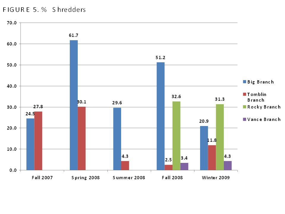
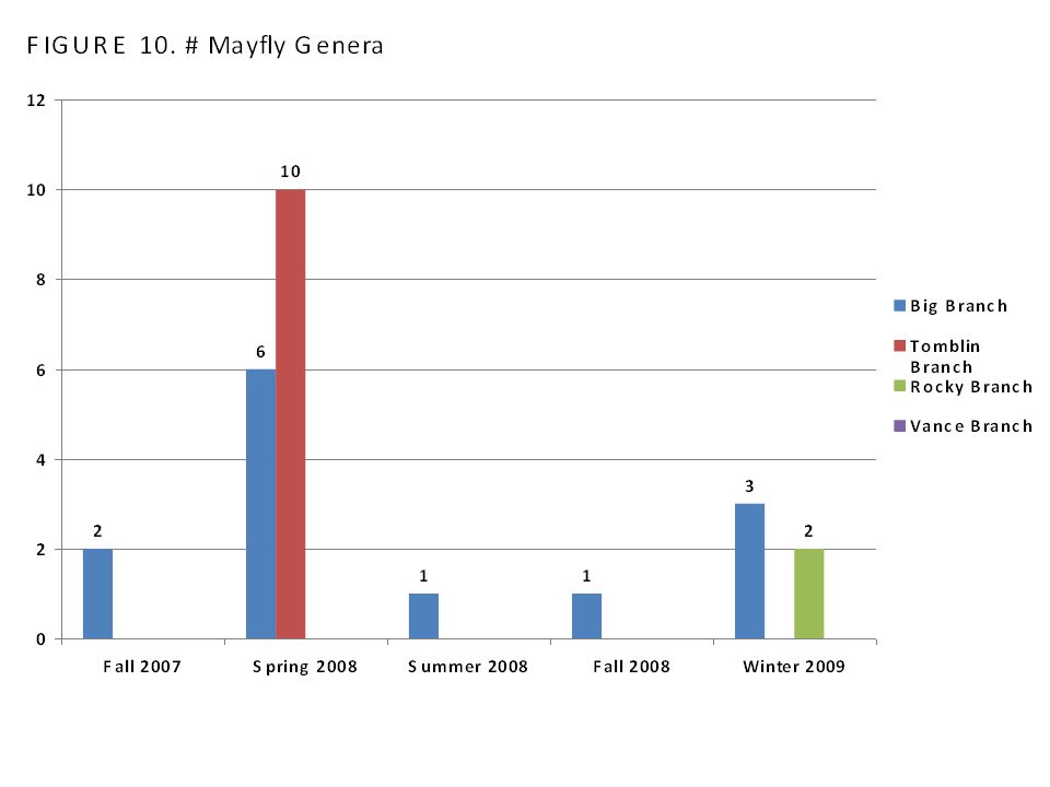
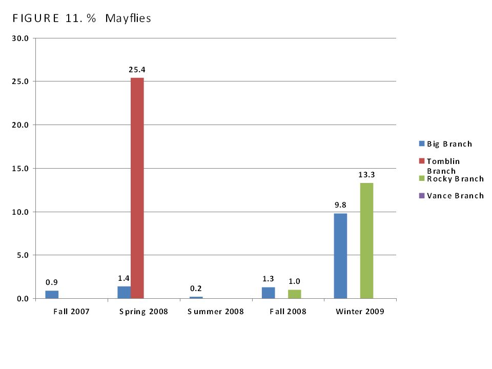
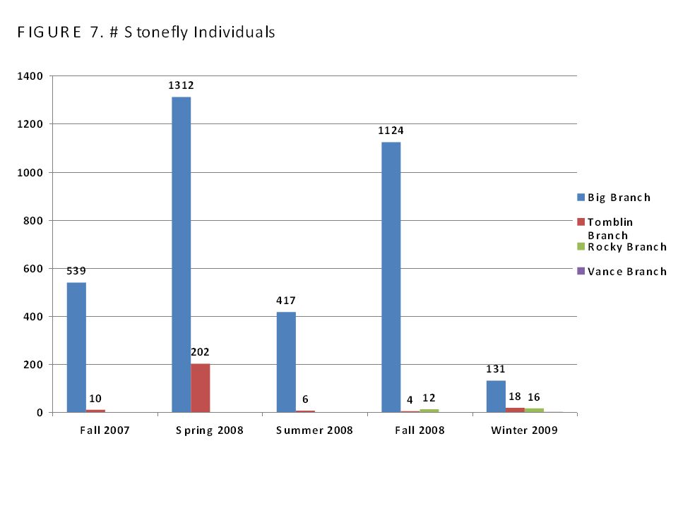
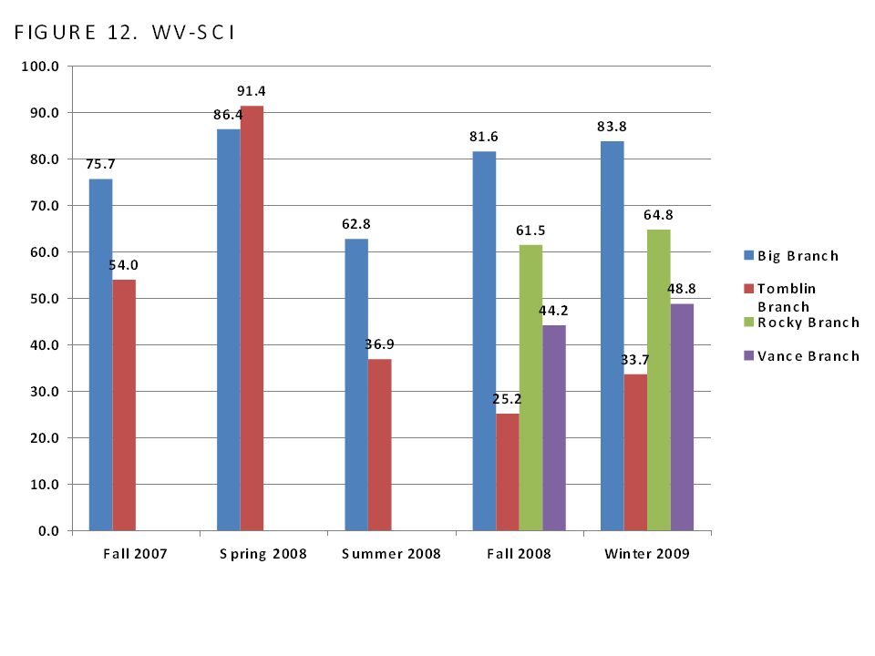
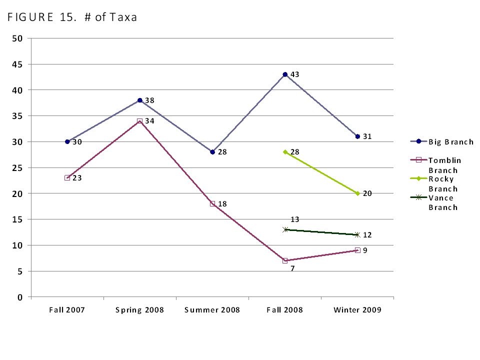
BENTHIC MACROINVERTEBRATE RESULTS – BIG BRANCH ________________________________________ TOTAL ABUNDANCE: 470 individuals in Winter 2009 to 2,383 in Fall 2008 TOTAL TAXA: 28 to 43 –High percentage of shredders (20.9% to 61.7%) WVSCI: 62.8 to 86.4 OVERALL: Desirable results
 WVSCI: 62.8 to 86.4 OVERALL: Desirable results")
25
BENTHIC MACROINVERTEBRATE RESULTS – TOMBLIN BRANCH ________________________________________ TOTAL ABUNDANCE: 187 to 505 TOTAL TAXA: 7 to 34 –Population of highly sensitive individuals in Spring 2008 –Shredders ranged from 2.5% to 30.1% WVSCI: Scores ranged from 25.2 to 91.4 OVERALL: 4 out of 5 sampling events resulted in poor outcomes, flow definitely the limiting factor

26
BENTHIC MACROINVERTEBRATE RESULTS – ROCKY BRANCH ________________________________________ TOTAL ABUNDANCE: 90 individuals in Winter 2009 to 377 individuals in Fall 2008 TOTAL TAXA: 20 to 28 –Population was fairly sensitive in Winter 2009 –Shredders over 30.0% in both sampling events WVSCI: 61.5 to 64.8 OVERALL: Scores not so bad considering Fall 2008 was a drought and other sampling event was during winter

27
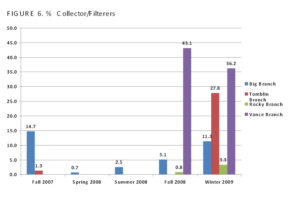
BENTHIC MACROINVERTEBRATE RESULTS – VANCE BRANCH ________________________________________ TOTAL ABUNDANCE: 467 individuals in Winter 2009 to 499 individuals in Fall 2008 TOTAL TAXA: 12 to 13 –Population was considered facultative to tolerant –Shredders were 3.4% to 4.3% –Collectors/Filters ranged from 43.7% to 36.2% WVSCI: 44.2 to 48.8 OVERALL: Scores not so bad considering Fall 2008 was a drought and other sampling event was during winter

28
DISCUSSION _______________________________________ OBSERVATIONS - TOMBLIN BRANCH: –Undisturbed reference stream –Rated very healthy during periods of adequate stream flow (WV-SCI of 91.4) –Rated poorly when stream flow was low (WV-SCI as low as 25.2)
 –Rated poorly when stream flow was low (WV-SCI as low as 25.2)")
29
DISCUSSION _______________________________________ OBSERVATIONS - BIG BRANCH: –Receives perennial down-dip outcrop seepage –Scored fairly well throughout various seasons –Contained mayflies, stoneflies, and caddisflies –Desirable results even when water chemistry variables were elevated (“sometimes mine water is better than little or no water”)
")
30
DISCUSSION _______________________________________ OBSERVATIONS - ROCKY BRANCH: –Perennial flow receiving flow from outcrop seepage –Scored moderately well and contained some mayflies, stoneflies, and caddisflies –Scored lower than Big Branch, but higher than Tomblin Branch during the same time frames (“at times, mine water may be better than little to no water”)
")
31
DISCUSSION _______________________________________________ OBSERVATIONS - VANCE BRANCH: –Perennial stream located directly downstream of fills and sediment ponds in heavily mined watershed –Contained a moderate number of individuals, but undoubtedly, water quality associated with sediment ponds and disturbances have affected stream noticeably –Scored higher than Tomblin Branch during the same time frames (“at times, mine water may be better than little to no water”)
")
45
CONCLUSIONS __________________________ A comparison of the data presented in this study to that presented by Pond et al. 2008 raises several questions:

46
CONCLUSIONS ___________________________________ Big Branch exhibits high specific conductivity with not mountaintop mining or valley fill construction –However, it continued to have a mayfly community Is it possible that the reductions observed by Pond et al. 2008 are not attributed to high conductivity but the effects of sediment ponds or changes in vegetation? –These are temporary effects that can be more easily remediated if deemed necessary

47
CONCLUSIONS ___________________________________ Vance Branch displayed a dramatic increase in filter feeders –The expected benthic community present immediately downstream of an impounding structure (such as a sediment pond) Are large populations of mayflies expected to be found below such structures?
 Are large populations of mayflies expected to be found below such structures")
48
CONCLUSIONS ___________________________________ Recommendation: –Regulatory agencies need to reconsider the issue of biological impairment and the methods currently utilized to measure its severity –Examine the success stories as well as the alleged failures –Agency and industry collaboration needed

Similar presentations


 926-0499, ext. 1529.>")
 and.>")


>")
 Stream Channel Pattern Substrate Chemical Properties pH Dissolved Oxygen Temperature Nutrients Turbidity.>")


. Background to RBP changes in community/assemblage composition used to evaluate existence and degree of impact.>")