Download presentation
Presentation is loading. Please wait.

1
Exploring the sea floor
Lesson 5

2
Mapping the Ocean Floor
Watch and take notes

3
Mapping the ocean floor quiz
1)When the ocean is emptied, what does the sea floor look like? 2)What device is used to take samples from the ocean floor? 3)What device is used to map the ocean floor in detail? 4) What was the significance of the electronic jellyfish on the ROV? 5)Where did the Dumbo octopus get its name? 6)What are underwater volcanoes called? 7)Where do you find deep sea corals? 8)How tall are the corals in the strait of Fl? 9)What is the mid-oceanic ridge? 10)Where is it exposed? 11) What is the largest underwater landscape?
When the ocean is emptied, what does the sea floor look like 2)What device is used to take samples from the ocean floor 3)What device is used to map the ocean floor in detail 4) What was the significance of the electronic jellyfish on the ROV 5)Where did the Dumbo octopus get its name 6)What are underwater volcanoes called 7)Where do you find deep sea corals 8)How tall are the corals in the strait of Fl 9)What is the mid-oceanic ridge 10)Where is it exposed 11) What is the largest underwater landscape")
4
World ocean Though generally described as several 'separate' oceans, these waters comprise one global, interconnected body of salt water sometimes referred to as the World Ocean or global ocean. This concept of a continuous body of water with relatively free interchange among its parts is of fundamental importance to oceanography.

5
The major oceanic divisions (largest to smallest):
Pacific Ocean Atlantic Ocean Indian Ocean (Southern Ocean) Arctic Ocean Southern Ocean, which, unlike other oceans, has no landmass separating it from other oceans and is therefore sometimes subsumed as the southern portions of the Pacific, Atlantic, and Indian Oceans, which encircles Antarctica and covers much of the Antarctic Arctic Ocean, sometimes considered a sea of the Atlantic, which covers much of the Arctic and washes upon northern North America and Eurasia
 Arctic Ocean. Southern Ocean, which, unlike other oceans, has no landmass separating it from other oceans and is therefore sometimes subsumed as the southern portions of the Pacific, Atlantic, and Indian Oceans, which encircles Antarctica and covers much of the Antarctic. Arctic Ocean, sometimes considered a sea of the Atlantic, which covers much of the Arctic and washes upon northern North America and Eurasia.")
6
Ocean What do you notice about this picture?

7
Ocean floor Flat and Lifeless? Varied Landmarks and full of Life?

8
Sea Level Ocean’s average height relative to land.
Throughout history sea level has changed Shifts in climate Growing or shrinking ice caps Ice ages = more land More water frozen in ice Warm periods = less land More water is liquid

10
Ocean Average Depth is ~12,081 ft Deepest part of the ocean
Mariana Trench (~36,200 ft) Same as on land Hills, valleys, mountains, etc Ocean is home to tallest mountains, widest plains and deepest valleys
 Same as on land. Hills, valleys, mountains, etc. Ocean is home to tallest mountains, widest plains and deepest valleys.")
11
bathymetry Characteristics of the ocean floor
The surfaces of the Moon and Jupiter have been mapped more thoroughly than the floor of the sea.

12
Ocean floor Mt Everest vs. Mauna Kea Which one is which?
Mauna kea in hawaii 4, 205 ft are above sea level

13
The Vast Unknown On January 7, 2005, only 400 miles from its base on Guam, the navy submarine USS San Francisco was traveling about 35 mph when it slammed into an uncharted mountain about 6,000 feet beneath the surface. One crew member died and 23 others were injured.

14
Ocean floor The familiar landscapes of continents are mirrored, and generally magnified, by similar features in the ocean basin. The largest underwater mountains, for example, are higher than those on the continents. Underwater plains are flatter and more extensive than those on the continents. All basins contain certain common features that include oceanic ridges, trenches, abyssal plains, and volcanic cones.

15
SEAFLOOR FEATURES

16
1) Continental Margin Region closest to land that is made up of 3 parts.
 Continental Margin Region closest to land that is made up of 3 parts.")
17
1a) Continental shelf Gently sloping land area along the edges of continents
 Continental shelf Gently sloping land area along the edges of continents")
18
1b) Continental slope Steep slope leading from the edge of a continent down to the seafloor
 Continental slope Steep slope leading from the edge of a continent down to the seafloor")
19
1c) Continental Rise Hill of sediment at the bottom of the steep slope near the edges of continents
 Continental Rise Hill of sediment at the bottom of the steep slope near the edges of continents.")
20
2) Abyssal plains Flat, featureless plain making up a large part of the seafloor They tend to be found at depths of meters. Oceanographers believe that abyssal plains are so flat because they are covered with sediments (clay, sand, and gravel) that have been washed off the surface of the continents for hundreds of thousands of years. More extensive in Atlantic and Indian Ocean because of constant river input of sediments.
 that have been washed off the surface of the continents for hundreds of thousands of years. More extensive in Atlantic and Indian Ocean because of constant river input of sediments.")
21
Seafloor sediments Covering the abyssal plains are seafloor sediments that have different origins. 3 types: 1) Terrigenous – Consists of mineral grains eroded from land. 2) Biogenous – Consists of shells and skeletons of marine animals and algae. 3) Hydrogenous – Consists of minerals that crystallize directly from ocean water.
 Terrigenous – Consists of mineral grains eroded from land. 2) Biogenous – Consists of shells and skeletons of marine animals and algae. 3) Hydrogenous – Consists of minerals that crystallize directly from ocean water.")
22
3) mid-ocean ridge Underwater mountain range, where new seafloor is created. Atlantic Mid-Ocean Ridge is largest in the world .Enormous mountain ranges, or oceanic ridges, cover the ocean floor. The Mid-Atlantic Ridge starts at Greenland, runs down the center of the Atlantic Ocean and ends at the southern tip of the Africa. At that point, it stretches around the eastern edge of Africa, where it becomes the Mid-Indian Ridge. Some scientists say this is a single oceanic ridge that encircles Earth, one that stretches a total of more than 40,000 miles.

23
Ocean ridges In most locations, oceanic ridges are 2,000 meters or more below the surface of the oceans. In a few places, however, they actually extend above sea level and form islands. Iceland, the Azores (about mi. off coast of Portugal), and Tristan de Cunha are examples of such islands.
, and Tristan de Cunha are examples of such islands.")
24
4) mid-ocean ridge Scientists believe ocean ridges are formed when magma emerges from Earth’s interior, a process known as seafloor spreading. Alfred Wegener developed continental drift theory, Pangaea Which led to Harry Hess’s proposal of seafloor spreading

25
5) trenches Deepest feature of the ocean, plunging deep below the seafloor. Trenches are long, narrow, canyon like structures, most often found next to a continental margin. They occur much more commonly in the Pacific than in any of the other oceans. The deepest trench on Earth is the Mariana Trench, which runs from the coast of Japan south and then west toward the Philippine Islands—a distance of about 1,580 miles. The British naval vessel, Challenger II surveyed the trench in 1951 and named the deepest part of the trench, the "Challenger Deep". Trenches are long, narrow, canyon like structures, most often found next to a continental margin. They occur much more commonly in the Pacific than in any of the other oceans. The deepest trench on Earth is the Mariana Trench, which runs from the coast of Japan south and then west toward the Philippine Islands—a distance of about 1,580 miles. The British naval vessel, Challenger II surveyed the trench in 1951 and named the deepest part of the trench, the "Challenger Deep".

27
5) Trenches Its deepest spot is 11,033 meters below sea level called the Challenger Deep in the Marianas Trench. Earthquakes and volcanic activity are commonly associated with trenches. Mariana Trench Video – 45 min

29
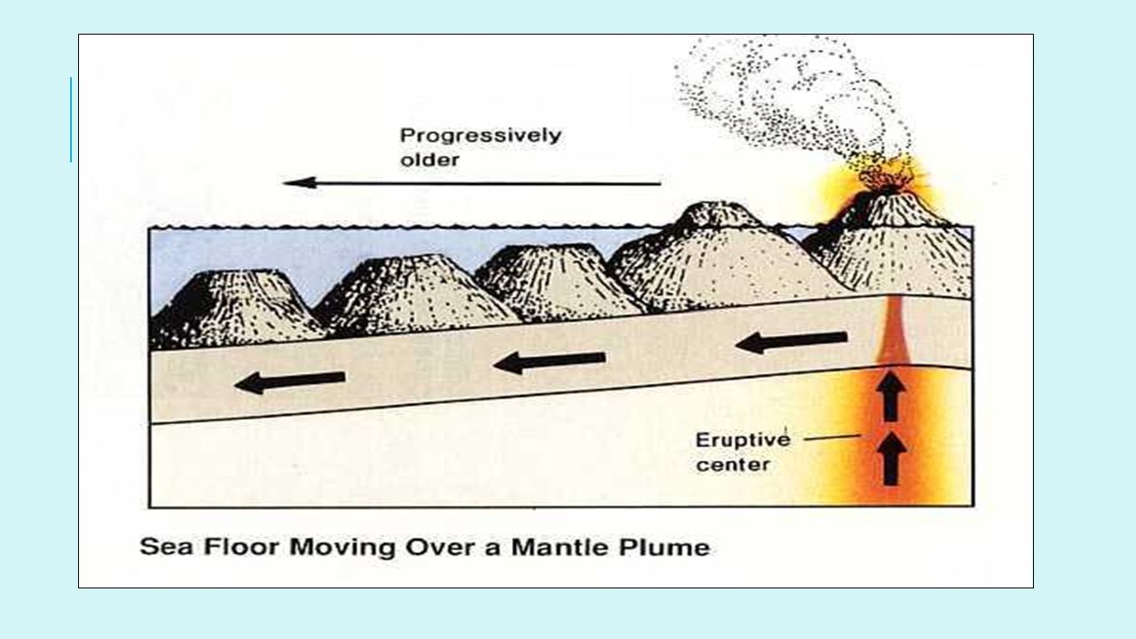
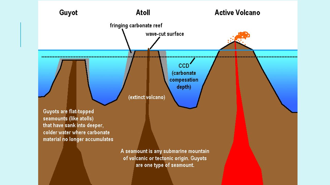
6) Volcanic cones Ocean basins are alive with volcanic activity. Magma flows upward from the mantle to the ocean bottom not only through rifts, but also through numerous volcanoes and other openings in the ocean floor. a) Seamounts are submarine volcanoes and can be either active or extinct. b) Guyots are a specific type of seamount with a flattened top. Extinct volcanoes that were once above sea level but have since receded below the surface. As they receded, wave or current action eroded the top of the volcano to a flat surface.
 Seamounts are submarine volcanoes and can be either active or extinct. b) Guyots are a specific type of seamount with a flattened top. Extinct volcanoes that were once above sea level but have since receded below the surface. As they receded, wave or current action eroded the top of the volcano to a flat surface.")
32
7) Submarine canyon Steep-sided underwater valley near the edge of a continent.
 Submarine canyon Steep-sided underwater valley near the edge of a continent.")
33
Ocean We know more about our moon and Mars than our Ocean
Only Mapped 10% of the ocean floor Why?

34
Ocean The moon and mars we can see Ocean we cannot…water impedes a lot
Pressure visual, etc Need to understand this Shipping routes National security Animals migrations Earth’s final frontier

35
Early Measurements Line with a weight on the end
Knots tied at different points Throw overboard and see at what knot the line is at and record Knots are called Plumb lines Early maps of the ocean floor

36
Post World War I Measurements
Sound Waves Sonar – Sound Navigation and Ranging Use echoes Sounds “pings” bounce off the floor and time return Like sound in an empty classroom versus a gym Must know how fast sound travels in water Early Mapping of Red Sea

37
Sonar ping satellite.net/marinescience/resources_nat/audio_video/lesson6/sonar.mp3

38
Sound in water Sound in water travels much faster than sound in air travels Avg speed is 1500 m/s (3000 miles per hour) Air = 340 m/s Can measure depth using: D= (1/2) T*V Sea depth = ½ Time * Velocity ½ because 1T = surface to floor and then floor to surface
 T*V. Sea depth = ½ Time * Velocity. ½ because 1T = surface to floor and then floor to surface.")
39
Today’s Sonar Sophisticated Sonar technology Side Scan and Multibeam
Locates shipwrecks, downed planes, schools of fish Side Scan and Multibeam

40
Side Scan Tow fish dragged behind a ship or attached to submersible
Computer generates image Receives INTENSITY rather than basic sonar Hard objects = more intense beams Metal ship and rocks Soft objects = less intense Mud and Sand Black areas are acoustic shadows…no sound Pictures of Seafloor, but not depth Good at locating

41
Multibeam Depth Measurements Emit pulse of sound from ships hull
Data are recorded at a wider angle Different Depths = Different Colors

42
MultibeAM 4fps-300Kbps.mov

43
Lab: A classroom model of the ocean floor
Page 95-97

44
Echolocation Animals that are unable to see in the dark
Determine distance and direction of objects Bats = find food or navigate trees or caves Toothed Whales Send out clicks Sound travels more efficiently in water than air MELON in their head Large fatty organ Focuses the sound Sounds received from cavities in lower jaw

45
Echolocation

46
Slow Process Ocean is so immense Use data from space
Very difficult and expensive to cover entire floor Use data from space Highs and lows of sea surface mirror seafloor Use satellites to measure underwater topography = BATHYMETRY

47
A few more details Need to look at ocean topography to understand why and where animals migrate, how things are related and what is going on there with currents, weather etc

48
Sea Level Changes Sea Level changes throughout history have changed the geography of the land and the continental shelves North America was once covered by a sea Coral Fossils in Boulder mountains

49
Seafloor Sediments Diverse and complex
Variety of abiotic and biotic factors Differ depending on the type of material they come from Land = TERRIGENOUS sediments Living organisms = BIOGENOUS sediments Smaller portion from chemical reactions

50
Soils Terrigenous sediments are primarily abiotic materials (rock & debris) that are broken down Carried by water, wind or ice (erosion) to the ocean As they move, they bump against other objects Smoothing the surface Composition depends on the parent material White vs black beaches?
 to the ocean. As they move, they bump against other objects. Smoothing the surface. Composition depends on the parent material. White vs black beaches")
51
Sediment types Black Soil – Hawaii – Eroded volcanic rock
White – Quartz based from granite rock or biogenous

52
Sediment Biogenous comes from broken parts of shells of marine organisms Common source is from microscopic phytoplankton Where there are lots of plankton Sea floor is typically biogenous Some white sand beaches made exclusively of these Some biogenous sediments come from weathering of coral reefs Open ocean, as quartz and terrestrial materials is limited the farther you go

53
Sediments tell us history
Information about physical ocean science processes, biological health and past climate

54
Sediments HYDROGENOUS sediments COSMOGENOUS sediments
Precipitate out of seawater Very mineral-rich COSMOGENOUS sediments Dust and large particles from space Very tiny fraction

55
Sediments and Migrations
Sediments are important for animal travels Some feed on resources in certain soils and others have to dive deeper

56
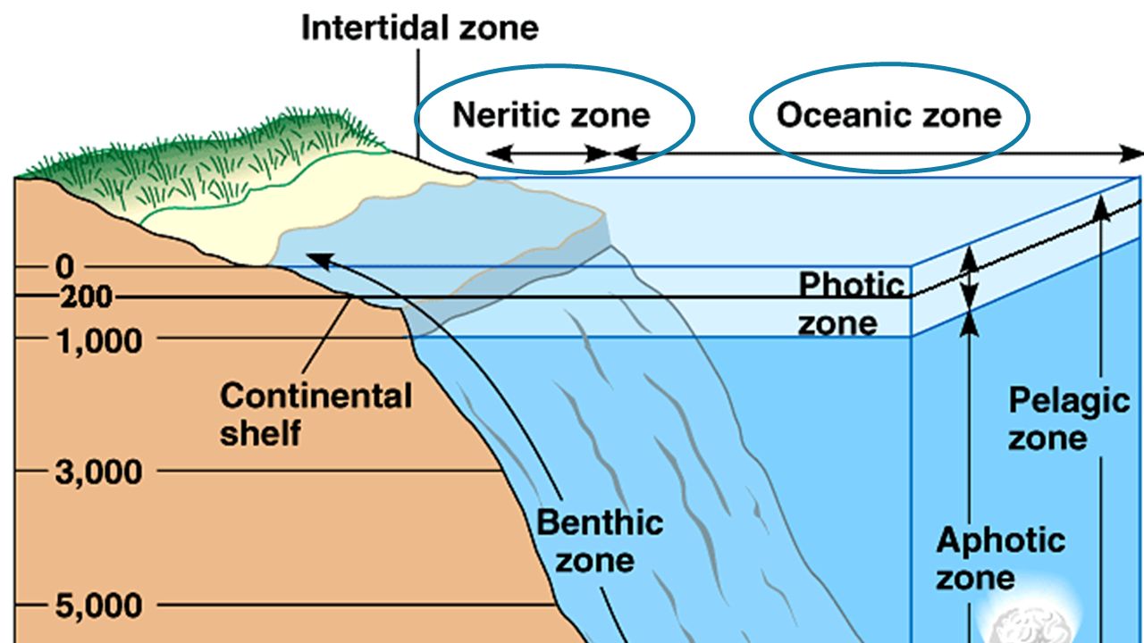
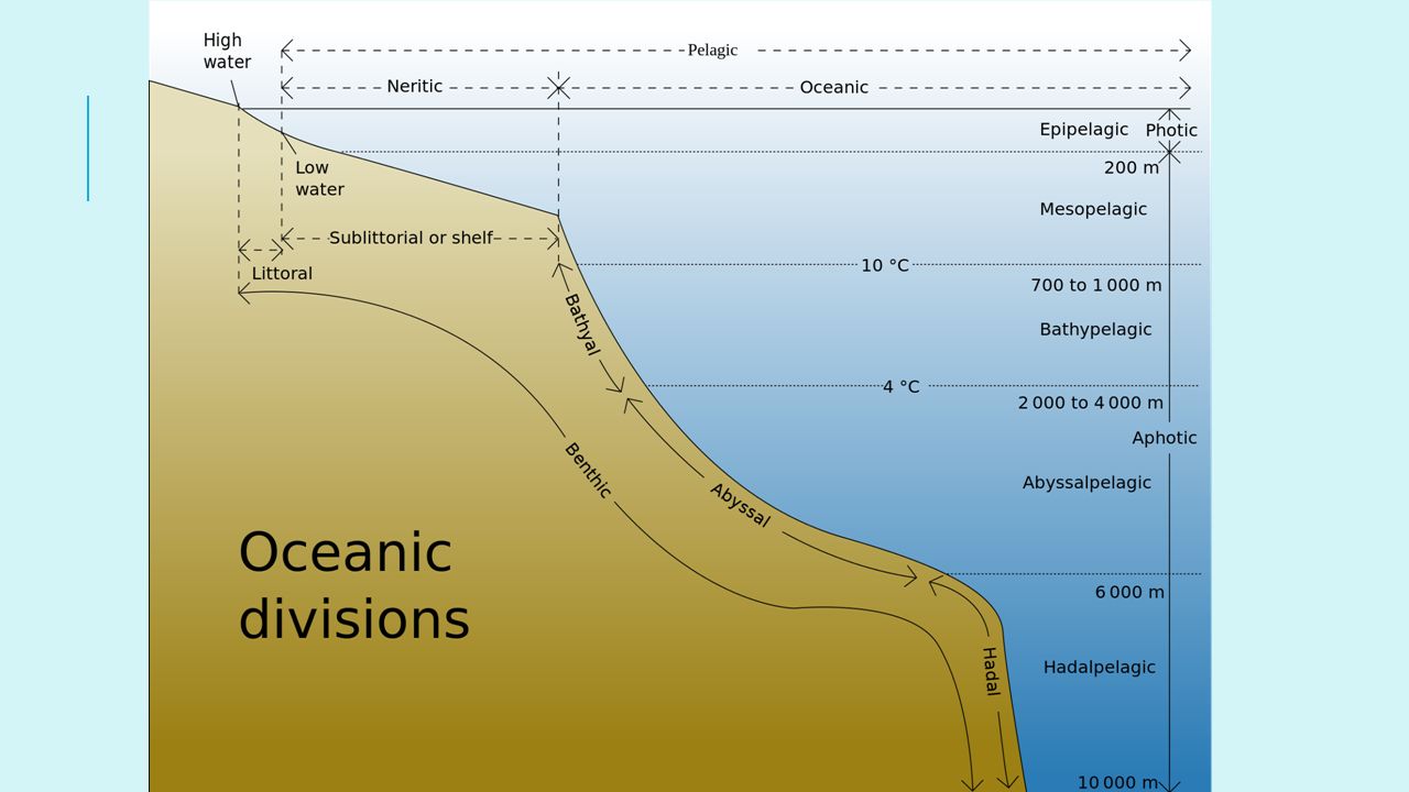
Ocean zones The ocean can be divided into two basic regions:
A. Pelagic Zone (anywhere in the water column) B. Benthic Zone (the seafloor)
 B. Benthic Zone (the seafloor)")
57
Pelagic Zone The Pelagic Zone is further divided horizontally into:
Neritic Zones (Coastal oceans) – Nearshore. - large variety of conditions - Salinity can increases by evaporation, or decrease from river input - Temperature changes rapidly - Most biologically productive part of the sea Oceanic Zones (Open Ocean) – Offshore. - Open ocean - 90% of the world’s ocean
 – Nearshore. - large variety of conditions. - Salinity can increases by evaporation, or decrease from river input. - Temperature changes rapidly. - Most biologically productive part of the sea. Oceanic Zones (Open Ocean) – Offshore. - Open ocean. - 90% of the world’s ocean.")
59
Pelagic zone Epipelagic zone – (0-200 meters)
Can also be divided vertically into: Epipelagic zone – (0-200 meters) Mesopelagic Zone (200–1000 meters) Bathypelagic Zone – ( meters) Abyssalpelagic Zone – ( meters) Hadalpelagic – (6000 – 10,000 meters)
 Mesopelagic Zone (200–1000 meters) Bathypelagic Zone – ( meters) Abyssalpelagic Zone – ( meters) Hadalpelagic – (6000 – 10,000 meters)")
62
splash Zone Supralittoral (splash zone) – rarely if ever covered with water Intertidal/littoral Zone – Regularly submerged and exposed with the fluctuating tide levels Sublittoral (sub – tidal) Zone – which extends to the edge of the continental shelf.
 Zone – which extends to the edge of the continental shelf.")
63
Splash zone

64
Light penetration Euphotic Zone (Photic Zone) Dysphotic Zone
Primary production occurs, light penetrates to 200m Dysphotic Zone Some light penetration, m Aphotic Zone Zero light penetration, >1000m

Similar presentations


 Depth = (time x 1500 m/sec)/2 (round trip) At 25 degrees.>")


, Indian (3.96km), Pacific (4.0km), Arctic (1.2km) and.>")

