Download presentation
Presentation is loading. Please wait.

2
GPS for H 2 0 ??? Greg W. Keel P.Eng. Parallel Geo-Services Inc. (250) 753-0050 gkeel@nanaimo.ark.com
")
3
Introduction n Why does GWA need to know about GPS? n Basic concepts of GPS n Corrected Vs Uncorrected GPS positioning n Different types of GPS equipment n MWLAP cross-reference pilot project in Okanagan n Q & A ???

4
Why GPS for GWA ? n Well and facility location is important for: u inventory of what facilities exist and where they are, u emergency response, u spatial understanding of water resources n Accurate well elevations can be used to help understand the aquifer n If properly applied...GPS can reliably establish horizontal locations and elevations

5
GPS Basic Concepts - Intro n GPS: Global Positioning System = NAVSTAR n US military designed, built, maintained…$20B n Always has been dual-use (military / civilian) n Initial concepts developed in early 1970s n First satellites launched in 1978 n 1980s: development of equipment / software / methodologies (limited satellites available) n 1986: Space Shuttle disaster delays GPS n early 1990s: GPS fully operational (Gulf War #1) n 2000: Selective Availability (SA) shut off…changes civilian accuracy from 100m to <10m (horizontal 95%)
 n Initial concepts developed in early 1970s n First satellites launched in 1978 n 1980s: development of equipment / software / methodologies (limited satellites available) n 1986: Space Shuttle disaster delays GPS n early 1990s: GPS fully operational (Gulf War #1) n 2000: Selective Availability (SA) shut off…changes civilian accuracy from 100m to <10m (horizontal 95%)")
6
GPS Basic Concepts - 2 n Continuous positioning anywhere on earth n 3D Position, Velocity, Time n 24 satellites, inclined orbits 20,000km high n Military tracks each satellite: known positions (ephemeris) n User’s GPS receiver tracks codes broadcast by each satellite, determines distance (pseudo-range) by measuring the transmission time and scaling by the speed of light n With 4 pseudo-ranges, plus their ephemeris, user’s GPS receiver can compute instantaneous 3D position by trilateration (geometric intersection of distances) n 3 terms for this methodology: single-point, autonomous, or uncorrected GPS positioning.
 n User’s GPS receiver tracks codes broadcast by each satellite, determines distance (pseudo-range) by measuring the transmission time and scaling by the speed of light n With 4 pseudo-ranges, plus their ephemeris, user’s GPS receiver can compute instantaneous 3D position by trilateration (geometric intersection of distances) n 3 terms for this methodology: single-point, autonomous, or uncorrected GPS positioning.")
8
GPS Basic Concepts - 3 n Uncorrected GPS positioning has achievable accuracies (95%) : horizontal <10m, and vertical <15m n WARNING: LOW POSITIONAL INTEGRITY ! n any errors…small or large…will affect the user’s computed position (and you probably will not know it) n reliable positioning (e.g. for a public database) requires better positional integrity - checking - the simplest way to do this with GPS is to apply differential corrections from a nearby GPS base station n any instantaneous errors “seen” at the GPS base station are formed into corrections and applied to the “rover” GPS measurements n DGPS rover positional integrity and accuracy are improved (95%) : horizontal <1m, and vertical <1.5m
 n reliable positioning (e.g. for a public database) requires better positional integrity - checking - the simplest way to do this with GPS is to apply differential corrections from a nearby GPS base station n any instantaneous errors seen at the GPS base station are formed into corrections and applied to the rover GPS measurements n DGPS rover positional integrity and accuracy are improved (95%) : horizontal <1m, and vertical <1.5m.")
10
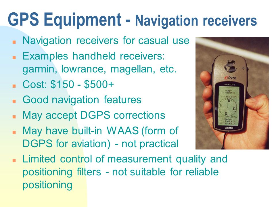
GPS Equipment - Navigation receivers n Navigation receivers for casual use n Examples handheld receivers: garmin, lowrance, magellan, etc. n Cost: $150 - $500+ n Good navigation features n May accept DGPS corrections n May have built-in WAAS (form of DGPS for aviation) - not practical n Limited control of measurement quality and positioning filters - not suitable for reliable positioning
 - not practical n Limited control of measurement quality and positioning filters - not suitable for reliable positioning.")
11
GPS Equipment - Professional DGPS n Professional DGPS receiver n Examples: Ashtech, Leica, Novatel, Trimble, etc n 3 components: antenna, receiver, datalogger n Costs: $5,000 - $15,000+ n Intelligent data capture - GIS ready n Advanced control of measurements and position filters…can be “tuned” for different accuracies / environments (e.g. for MWLAP cross-referencing pilot)
.")
12
GPS Equipment - Survey grade n Survey-grade instruments n Carrier-phase measurements produce very precise relative baselines (few mm) n Can be applied “static” or “kinematic” as long as the tracking conditions are good (mostly open) n Most expensive ($25,000+), and most demanding form of GPS.
 n Can be applied static or kinematic as long as the tracking conditions are good (mostly open) n Most expensive ($25,000+), and most demanding form of GPS.")
13
MWLAP cross-referencing pilot n >250 water systems in Okanagan n Golder and Associates n Inventory & locations: u wells / intakes u storage facilities u treatment facilities u monitoring sites Equipment: Trimble Pro-XR with CDGPS real-time differential corrections. Data collection parameters designed to reliably achieve <5m horizontal and vertical accuracies (actual accuracies are better).
..")
14
MWLAP cross-referencing pilot n Summaries to-date: u >300 wells/intakes u >370 monitoring sites u >130 treatment facilities u >180 storage facilities n GPS data is emailed to Parallel Geo-Services for check / edit / export in final formats, then returned to Golder for entry to DWIMP database. n Offsets applied when it is not possible / practical to place the GPS antenna on the center of the feature (see next slide).
..")
17
Questions... n Greg W. Keel P.Eng. n Parallel Geo-Services Inc. n (250) 753-0050 n gkeel@nanaimo.ark.com
 n")
Similar presentations


 is a system of satellites maintained by the US Department of Defense for.>")


. NAVSTAR Global Positioning System (GPS) Globally.>")


>")


