Download presentation
Presentation is loading. Please wait.

2
Map Using the Sun Using the Stars Compass What about moss?

3
Which way is North on the map? How do you know?

5
One way to use the sun to find direction is through the use of shadows. That shadow following you around for your entire life is carrying a useful secret. Your shadow always knows where it is in relation to you and the sun, and it never fails to point in the right direction if only we know how to use it.

6
Although your body casts an excellent shadow when the sun is shining, you probably do not want to stand in one position without moving for ten or twenty minutes. An inanimate object such as a straight stick will work just as well.

7
On a sunny day plant a straight stick in the ground as vertically as possible. As shown in the photo you need to select an area where the shadow cast by the stick is easily visible on the ground.

8
The bright sun – if it is too cloudy you will not be able to observe a shadow. A straight stick about.5 meters (1.5 feet) or longer. Two pebbles or other means of marking a point on the ground.
 or longer. Two pebbles or other means of marking a point on the ground..")
9
Mark the end of the stick shadow with a pebble. Wait for fifteen minutes and go visit your stick again. It should have moved. Mark the end of this stick shadow. Draw a straight line between the two markers you have placed. This is your East–West line.

10
As you can see from the magnetic compass placed along the line made by the shadow stick method, the line points very closely to the true East-West direction. The first mark you made is on the west end of the line and the second mark on the shadow is on the east end.

11
To find the North–South directions, draw a line perpendicular to your East– West line. Looking East, North will be on the left side of the line you drew and South will be on the right side.

12
As you know, the sun rises in the east and sets in the west. As an object bathed in sunlight casts its shadow, the shadow moves in exactly the opposite direction to the movement of the sun. Therefore, the shadow is moving eastward as the sun moves westward. Therefore, you can track the movement of a shadow on the ground and use this directional information for navigation!

13
Those of us in the Northern Hemisphere have Polaris, also known as the North Star or Pole Star, positioned directly north to guide us. As discussed in an earlier Survival Topics article, knowing how to find the North Star is easy if you know how to find the Big Dipper constellation. The Southern Hemisphere has the constellation Crux, also known as the Southern Cross.

14
Many people think the North Star is one of the brightest stars in the sky and so is easy to find. In actuality the star is not so outstanding in its order of magnitude, or brightness, which is about average when compared to all the other stars.

15
By shear luck, the northern axis of the earth points directly toward the North Star. This means that when you are observing this star you are facing true north toward the North Pole. Because of this we also call the North Star the Polestar or Polaris, its astronomic name.

16
When you are facing the North Star you are looking toward true north. This is because by chance this lodestar lines up with the celestial sphere almost perfectly, so that all other stars appear to rotate around it. Simply by finding the North Star travelers are able to determine all the points of the compass: westward would be on your left, eastward to the right, and southward in back of you.

17
Locate the Big Dipper in the northern sky. Depending upon the time of the year constellation of stars may be tipped in different directions as it rotates around the polestar. As shown in the diagram, locate the two stars that form the outer edge of the Big Dipper. Draw an imaginary line straight through the two stars of the dipper edge and toward the Little Dipper. The line will point very close to the handle of the Little Dipper. The brightest star in the Little Dipper is at the end of its handle. This is the North Star.

18
There are four basic points on a compass. These four points are at the top and the bottom, and on the right and left sides of a compass. They are called the Cardinal Directions or points of the compass.

19
You see this red and black arrow? We call it the compass needle. Well, on some compasses it might be red and white for instance, but the point is, the red part of it is always pointing towards the earth's magnetic north pole. That's basically what you need to know. It's as simple as that.

20
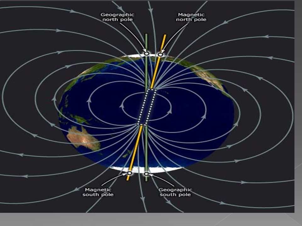
Magnetic North Pole Geographic North Pole The point on the surface of the Northern Hemisphere at which the Earth's magnetic field points vertically downwards. The North Magnetic Pole moves gradually over time. The point in the northern hemisphere where the Earth's axis of rotation meets the Earth's surface. It should not be confused with the North Magnetic Pole. The North Pole is the northernmost point on Earth, lying diametrically opposite the South Pole. At the North Pole all directions point south; all lines of longitude converge there, so its longitude can be defined as any degree value. The North Pole is located in the middle of the Arctic Ocean amidst waters that are almost permanently covered with constantly shifting sea ice.

23
The angle between the geographic and the magnetic meridian at a given point, expressed in plus degrees east or minus degrees west of true north.

25
Magnetize the needle by rubbing it 20 times with one end of the bar magnet. Make sure to rub in the same direction each time. Fill the pie pan with 1 inch of water. Make a float by placing the Styrofoam lid in the center of the pan. Place the magnetized needle in the center of the float and center it in the middle of the pan. Watch as the needle spins slowly. The needle will stop when its north pole (positive end) is pointing toward the Earth’s Magnetic North Pole.
 is pointing toward the Earth’s Magnetic North Pole..")
26
Now you know which way is North! Which way is South? Which way is East? West? Try a different type of needle. Do they work the same?

27
Directions- The line or course upon which anything is moving or aimed to move, or in which anything is lying or pointing; aim; line or point of tendency; direct line or course; as, the ship sailed in a southeasterly direction. Map- a representation, usually on a flat surface, as of the features of an area of the earth or a portion of the heavens, showing them in their respective forms, sizes, and relationships according to some convention of representation Northern hemisphere- the half of the earth between the North Pole and the equator Southern hemisphere - the half of the earth between the South Pole and the equator

28
Cardinal directions - the directions of north, south, east, and west, commonly denoted by their initials: N, S, E, W. East and west are at right angles to north and south, with east being in the direction of rotation and west being directly opposite. Ordinal directions - the directions between the cardinal points are the intermediate or ordinal directions: north-east (NE), north-west (NW), south- west (SW), and south-east (SE). Compass- an instrument for determining directions, as by means of a freely rotating magnetized needle that indicates magnetic north
, north-west (NW), south- west (SW), and south-east (SE). Compass- an instrument for determining directions, as by means of a freely rotating magnetized needle that indicates magnetic north.")
29
Magnetic North Pole - the point on the surface of the Northern Hemisphere at which the Earth's magnetic field points vertically downwards (i.e., the "dip" is 90°). It differs from the Geographic North Pole. The North Magnetic Pole moves gradually over time. Geographic North Pole - the point in the northern hemisphere where the Earth's axis of rotation meets the Earth's surface. It should not be confused with the North Magnetic Pole. The North Pole is the northernmost point on Earth, lying diametrically opposite the South Pole. At the North Pole all directions point south; all lines of longitude converge there, so its longitude can be defined as any degree value. The North Pole is located in the middle of the Arctic Ocean amidst waters that are almost permanently covered with constantly shifting sea ice.

30
Magnetic Meridian- A meridian (or line of longitude) is an imaginary arc on the Earth's surface from the North Pole to the South Pole that connects all locations running along it with a given longitude Magnetic declination - the angle between the geographic and the magnetic meridian at a given point, expressed in plus degrees east or minus degrees west of true north
 is an imaginary arc on the Earth s surface from the North Pole to the South Pole that connects all locations running along it with a given longitude Magnetic declination - the angle between the geographic and the magnetic meridian at a given point, expressed in plus degrees east or minus degrees west of true north")
Similar presentations