Download presentation
Presentation is loading. Please wait.

1
Labs Start Next Week Don’t forget your lab book!!! Read through labs ahead of time Exploring the Deep: GEO/OC 103 Lab Manual by Hall-Wallace et al. TA assignments now updated on web –dusk.geo.orst.edu/oceans/103labs.html

2
Shape of the Seafloor Chapter 2

3
Techniques of Bathymetry - 1 Challenger expedition (1872-1876) -1st systematic bathymetric survey –ocean floor not flat - significant topographic relief German ship Meteor (1920’s) - 1st echosounding survey –sounds travels through water much better –velocity = distance/time –SONAR (Sound Navigation and Ranging)
 -1st systematic bathymetric survey –ocean floor not flat - significant topographic relief German ship Meteor (1920’s) - 1st echosounding survey –sounds travels through water much better –velocity = distance/time –SONAR (Sound Navigation and Ranging)")
4
Bathymetry - 2 WWII - U.S. Navy further developed SONAR technology –knowledge of the enemy –knowledge of the ocean 1950’s - 1960’s - single, focused high- frequency, short wavelength sound beam –“wide-beam” bathymetry –sound beam spreads out as it reaches bottom –range of depths - fuzzy estimate

5
single, focused high-frequency, short wavelength sound beam

6
Bathymetry - 3 1970’s - revolution in bathymetric mapping with multibeam bathymetry multiple, focused, high-frequency, short wavelength sound beams –“narrow-beam” or “multibeam” bathymetry –sound beam stays narrow and focused all the way to the bottom –depths much more precise –e.g., Sea Beam has 16 beams, Sea Beam 2000 has 121, Simrad EM120 has 191

7
multiple, focused, high-frequency, short wavelength sound beams A Gigabyte of data a day A Gigabyte of data an hour

8
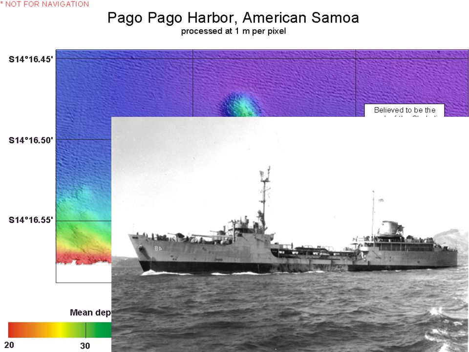
Bottom Coverage & Data Density by Survey Method LeadlineSingle Beam Multibeam 1-2 K soundings per survey 500 - 750 K soundings per survey 400,000 – 1,000,000 K soundings per survey Image courtesy of NOAA & UNH

17
Shallow Water Multibeam

18
Shallow Water Multibeam (cont.)
")
19
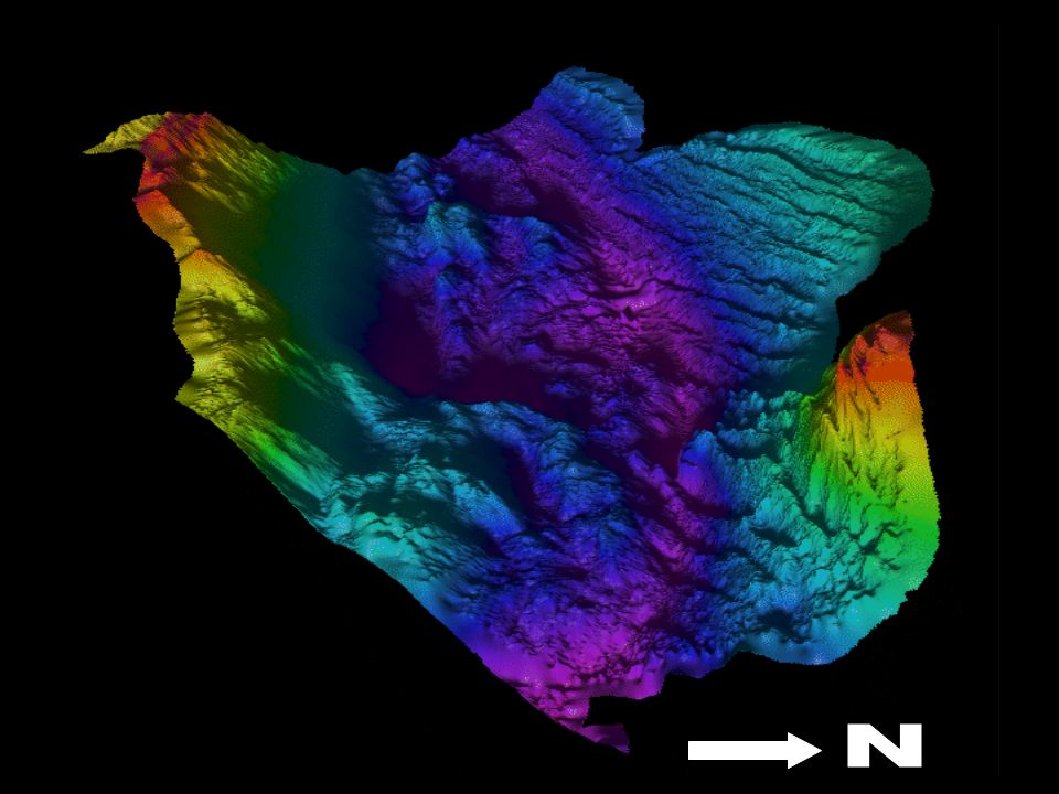
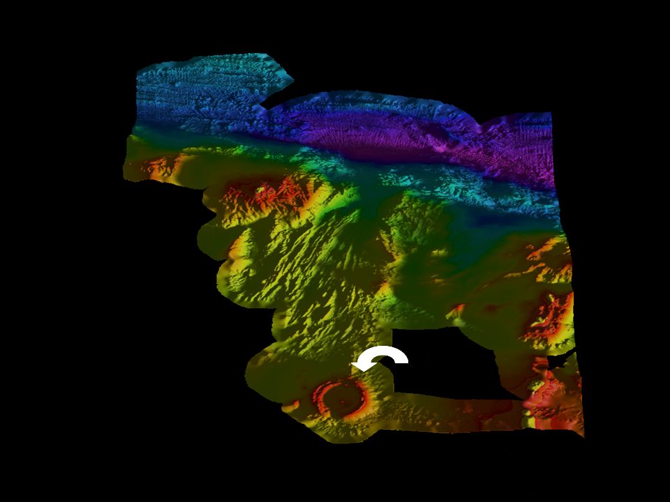
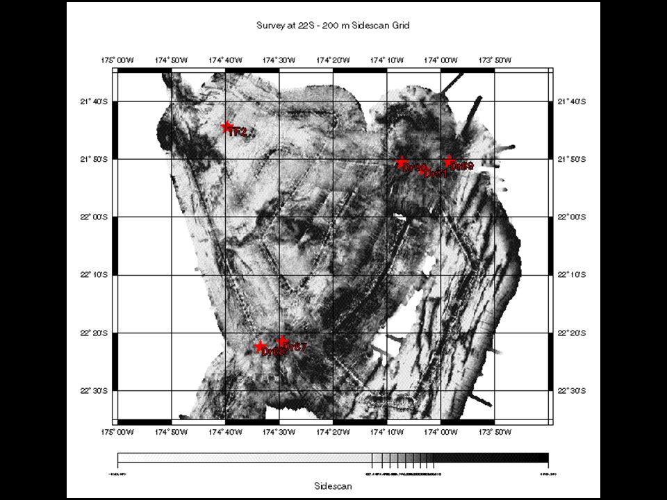
Tutuila Surveys

23
Fagatele Bay National Marine Sanctuary

24
FBNMS Benthic Habitat

25
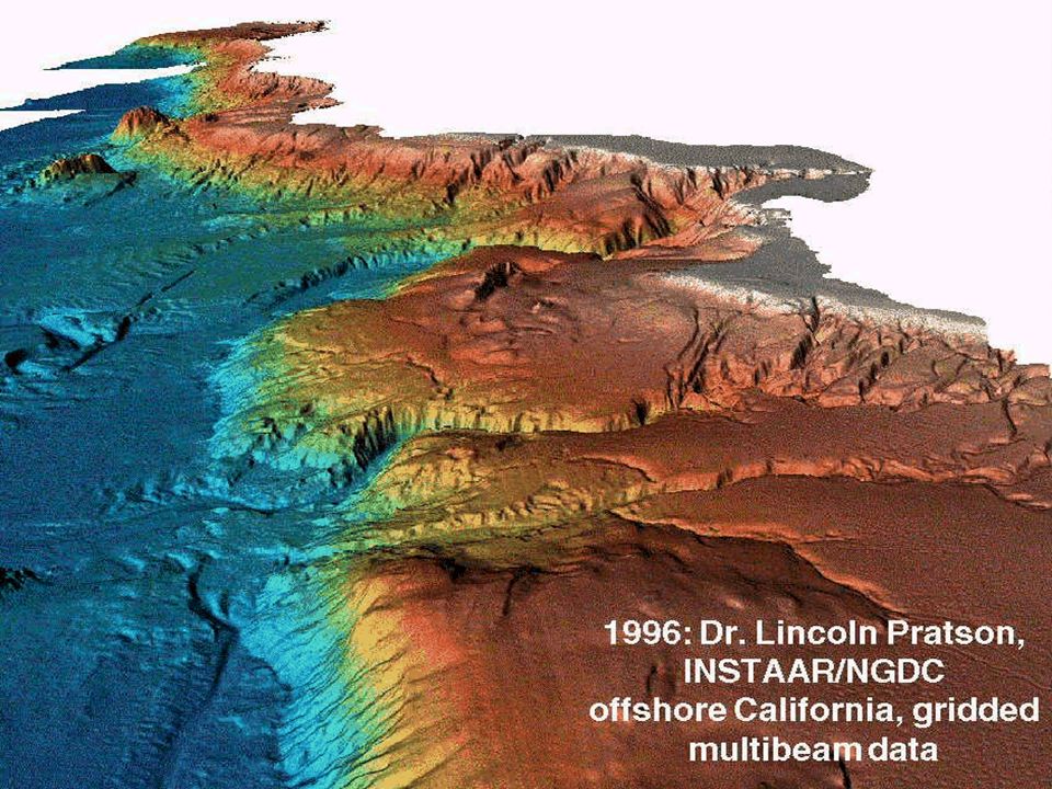
Goldfinger et al., OSU Active Tectonics & Seafloor Mapping Lab Oregon Department of Fish & Wildlife Need for Mapping Oregon Territorial Seafloor Siletz Bay Need for Mapping Oregon Territorial Seafloor Siletz Bay

26
Applications for Mapping Tsunami Runup Models - Evacuation Planning Habitat Restoration Shoreline Change Analysis Analyzing Storm Impacts - Coastal Erosion Fisheries Management Commercial Fishing Marine Reserve Design Emergency Response, Impact Assessment Port Security Maps and VisualizationsNavigation Products, Services Wave EnergyOil Spill Response, Tracking Coastal tourism, recreationMANY others

27
dusk.geo.orst.edu/3mile/consensus_statement.pdf

28
“Fine Scale” Mapping on the order of tens of meters to meters features the size of a can of beer!

29
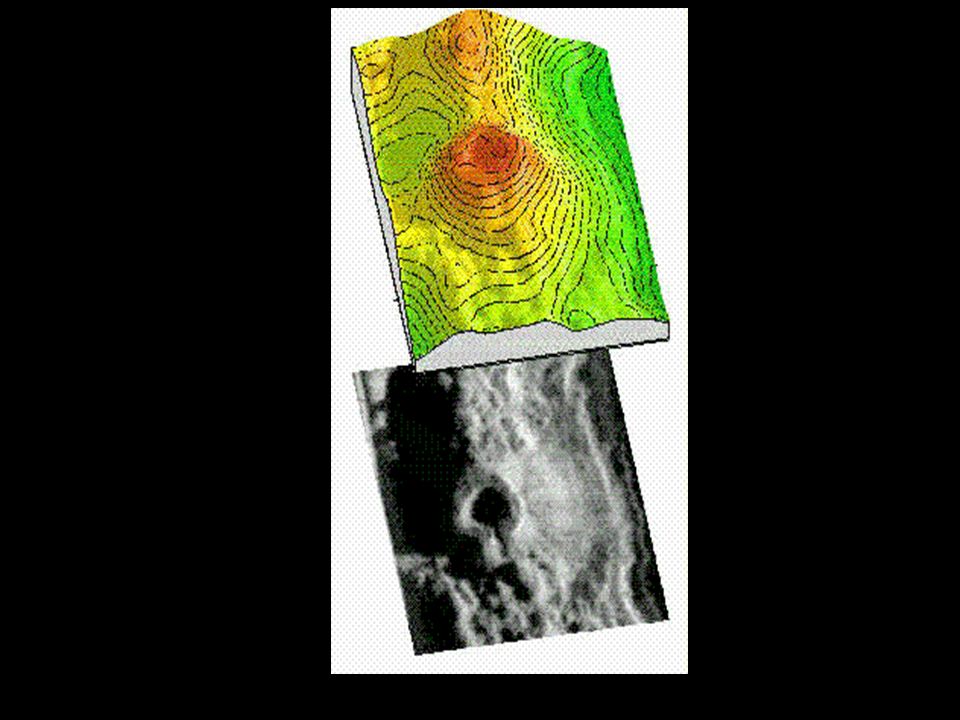
Image courtesy of Dan Fornari, Woods Hole Oceanographic Institution Study Area

30
2005 HURL Sub & ROV surveys Ka‘imikai-o-Kanaloa Pisces IV or V RCV-150 HURL = Hawaii Undersea Research Lab ROV= remotely-operated vehicle

31
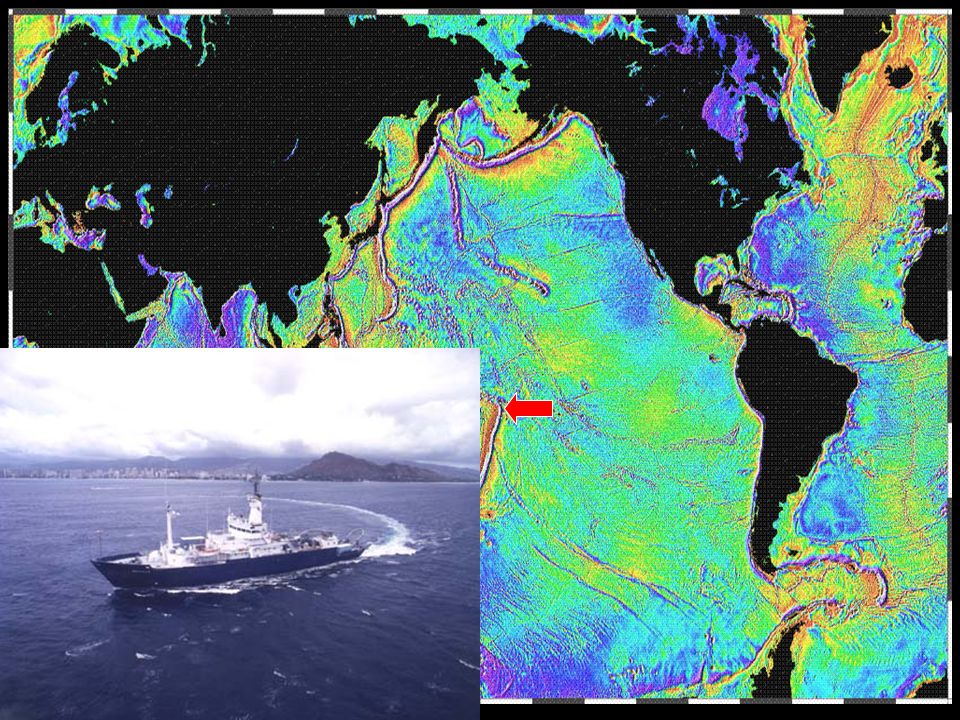
Sonar Also Used as... a “catscan” of oceans to see water structure ABOVE seafloor an “x-ray” of seafloor to see structure BENEATH seafloor –seismic reflection & seismic refraction –low frequency, long-wavelength sound sidescan sonar to get pictures of seafloor in addition to depth –backscatter strength as opposed to traveltime

32
Sidescan Sonar Image courtesy of USGS Woods Hole

33
DSL-120 Vehicle Image courtesy of USGS Woods Hole Image courtesy of WHOI Deep Submergence Lab and Dr.Dan Fornari

38
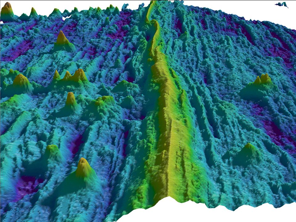
Resolution with multibeam bathymetry can see things on seafloor the size of this room –swath width of 6 km or 3.7 miles good, high-resolution maps possible only since 1980’s other instruments needed to see things smaller than size of room –remotely-operated vehicles (ROVs) –submersibles
 –submersibles")
40
Seafloor Features: Continental Margins continental shelf - extends from shore to a point marked by great increase in slope continental slope - steep slope beyond the continental shelf break slopes often cut by submarine canyons –turbidity currents - dense flows of sediment- laden water –deepsea fans continental rise abyssal plain - extensive, flat

42
Seafloor Features: Deep Ocean seamounts - underwater volcanoes 500 m to 1000 m high –flat-topped ones are called guyots –volcanic features (buoyed up by hot rock, lava) abyssal hills - features around 200 m high –pervasive on seafloor –volcanic AND tectonic in origin - still debated
 abyssal hills - features around 200 m high –pervasive on seafloor –volcanic AND tectonic in origin - still debated")
44
Seafloor Features: Deep Ocean Plate Boundaries –Ridges (Rises), Trenches, Transform Faults, Fracture Zones
, Trenches, Transform Faults, Fracture Zones")
Similar presentations


 Depth = (time x 1500 m/sec)/2 (round trip) At 25 degrees.>")


