Download presentation
Presentation is loading. Please wait.

1
Utilizing Radar Measured Velocity Fields to Forecast Turbine Wind Speeds James B. Duncan Jr. 1, Dr. Brian D. Hirth 1, Dr. John L. Schroeder 2 1 National Wind Institute, Texas Tech University, Lubbock, TX, USA 2 Department of Geosciences, Texas Tech University, Lubbock, TX, USA NAWEA 2015 Symposium Blacksburg, Virginia, USA, June 10 th, 2015

2
Introduction and Motivation Wind energy today…. Multi-billion dollar industry with over 60+ MW (through 2014) deployed. Ultimate goal of decreasing the cost of energy and mitigating risk. AWEA/DOE/BNEF
 deployed. Ultimate goal of decreasing the cost of energy and mitigating risk. AWEA/DOE/BNEF.")
3
Wind Turbine Control Systems and Remote Sensing Conventional wind turbine feedback controllers are entirely reactive rather than proactive. Transients such as gusts, varying shears, and directional changes in the inflow all represent UNKNOWN disturbances. Recent developments in remote sensing have led to much interest in the possibility of improving wind turbine controllers by providing preview information of the approaching wind field. Nacelle-mounted Look-Ahead Systems –Benefits…. –Limitations… ?

4
Aim of Research Although information of the near-upstream flow conditions has been examined through the use of nacelle mounted LIDAR systems, employing three dimensional wind field maps derived from scanning instruments to provide an extended wind speed forecast for individual turbine locations has never been investigated.

5
Radar Basics and Experimental Setup Texas Tech University maintains two-research grade mobile Ka- band Doppler radar systems. A single radar system is limited to deriving the radial component. A dual-Doppler scanning strategy allows for the extraction of the full horizontal velocity vector and construction of horizontal wind field maps. Radar Specifics Half-Power Beamwidth 0.49° Along-Beam Range Resolution 15m Revisit Time~45 sec

6
Dual-Doppler Horizontal Wind Speed Synthesis (~45 sec Revisit Time)
")
7
Preliminary Methods In order to provide preview measurements of the upstream flow, the following steps must be taken: 1. Derive an upstream projection representative of the inflow. Look angle of the upstream projection (Rotor Sweep Area Average of WD located 1D Upstream). Spatial dimensions of the upstream projection (Point Measurement Along Path). 2. Forecast wind speeds measured upstream to the location of turbine. Analyze wind speeds at hub height within upstream projection at distances between 1-6 D upstream at intervals of ~10 m. Assuming the wind speed magnitude of the features remains constant with time, derive time offset for future feature arrival. 3. Generate a future-forecasted time series.
. Spatial dimensions of the upstream projection (Point Measurement Along Path). 2. Forecast wind speeds measured upstream to the location of turbine. Analyze wind speeds at hub height within upstream projection at distances between 1-6 D upstream at intervals of ~10 m. Assuming the wind speed magnitude of the features remains constant with time, derive time offset for future feature arrival. 3. Generate a future-forecasted time series..")
8
ABL Streaks and Advection of Momentum Organized coherent structures are embedded within the turbulent flow- fields of the ABL. Near-surface streaks, defined as elongated areas of enhanced/reduced wind speeds (Traumner et al. 2015). Shown using full-scale radar measurements to be skewed left of the wind direction (Lorsolo et al. 2008; Marathe 2014). Variation in Advection Between Actual and Projected Motion Step 1Step 2Step 3Step 4Step 5Avg Feature 14.44°8.09°5.7°8.3°6.2°6.55° Feature 22.8°3.9°5.6°5.5°2.6°4.07°
. Shown using full-scale radar measurements to be skewed left of the wind direction (Lorsolo et al. 2008; Marathe 2014). Variation in Advection Between Actual and Projected Motion Step 1Step 2Step 3Step 4Step 5Avg Feature 14.44°8.09°5.7°8.3°6.2°6.55° Feature 22.8°3.9°5.6°5.5°2.6°4.07°.")
9
Variation in Upstream Projection Paths Propagation of upstream conditions based upon the governing wind direction is not sufficient to provide an extended preview of the approaching wind field. Variation between wind direction and actual momentum advection leads to inaccuracies in the future-forecasted time series. 1.03 ms -1 (49.5 sec) 0.82 ms -1 (19.5 sec) 0.77 ms -1 (34.5 sec)
 0.82 ms -1 (19.5 sec) 0.77 ms -1 (34.5 sec).")
10
Adapted Methods Upstream projection offset counterclockwise of the governing wind direction by four degrees. Adjust Upstream Path to Account for Momentum Advection CC Degree Offset RMSE Value 3-sec Avg.5-sec Avg. 00.74710.7227 10.72100.6952 20.69780.6724 30.68030.6556 40.67400.6468 50.67680.6469 60.68490.6588 0.073 ms -1 & 0.076 ms -1 reduction in RMSE for 3 and 5 second averages respectively

11
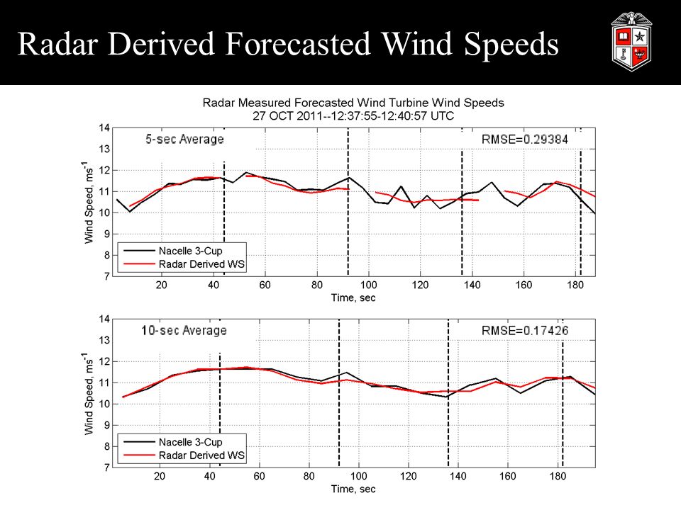
Radar Derived Forecasted Wind Speeds

13
Forecasts Across Observational Period (52 min 12 sec) Averaging TimeRMSE Value (m/s) 1-sec0.71 3-sec0.67 5-sec0.65 10-sec0.59
 Averaging TimeRMSE Value (m/s) 1-sec sec sec sec0.59")
14
Concluding Remarks Preliminary results demonstrate the ability to predict future conditions at the turbine leveraging radar- derived dual-Doppler horizontal wind field maps. Scanning instruments allow for the ability to accurately forecast wind speeds 45+ seconds or more in advance from the turbine. Elevating the instruments to hub height could reduce time required to collect hub height information by an order of magnitude further enhancing this method. Coordinated deployment of multiple specialized Doppler radar systems can provide the foundational information to construct proactively responding turbine control systems.

15
Next Steps…Plant Scale Acknowledgements: The use of radar technology to document wind plant complex flows occurred with support from the United States Department of Energy Congressionally Directed Project: Great Plains Wind Power Test Facility (DE-FG-06-GO86092). This specific research is funded through support from the National Science Foundation: Building the Foundation for Smart Wind Farms through First-Order Controls Opportunities based on Real-Time Observations of Complex Flows (CBET-1336935).
..")
17
References Bossanyi, E. A., A. Kumar, and O. Hugues-Salas, 2014: Wind turbine control applications of turbine-mounted LIDAR. J. Phys.: Conf. Ser., 555, 012011. Hirth, B. D. and J. L. Schroeder, 2013: Documenting wind speed and power deficits behind a utility-scale wind turbine. J. Appl. Meteor. Climatol., 52, 39-46. Hirth, B. D., J. L. Schroeder, W. S. Gunter, and J. G. Guynes, 2015: Coupling Doppler radar- derived wind maps with operational turbine data to document wind farm complex flows. Wind Energy, 18, 529-540. Lorsolo, S., J. L. Schroeder, P. Dodge, and F. Marks, 2008: An observational study of hurricane boundary layer small-scale coherent structures. Mon. Wea. Rev., 136, 2871-2893. Marathe, N. 2014: Investigation of power performances and wakes of wind turbines under yawed flow. Dissertation, Texas Tech University, 141 pp. Mikkelsen, T., N. and Couauthors, 2013: A spinner-integrated wind lidar for enhanced wind turbine control. Wind Energy, 16, 625-643. Schlipf, D., J. Anger, S. Kapp, O. Bischoff, M. Hofsa ̈ ß, A. Rettenmeier, and M. Ku ̈ hn, 2011: Prospects of optimization of energy production by lidar assisted control of wind turbines. Proc. European Wind Energy Conference and Exhibition, EWEA, Brussels, 14-17 2011. Tra ̈ umner, K., T. Damian, C. Stawiarski, and A. Wieser, 2015: Turbulent structures and coherence in the atmospheric surface layer. Bound.-Layer Meteor., 154, 1-25. Atmosphere to Electrons (A2e) Initiative Overview, DOE Wind and Water Power Technologies Office, 2014.
 Initiative Overview, DOE Wind and Water Power Technologies Office,")
Similar presentations


.>")

 2D wind mapping using DOW data and surface roughness DOW Radar in Galveston, Texas. Hurricane Ike (2008) Correlation.>")


 Products and Measurements Presented by Patrick Selmer Goddard advisor: Dr. Matthew McGill Assisted.>")


 Wind Observations Vectors have both magnitude and direction. Wind is a vector quantity. The components of wind.>")
 Hurricane Rita (2005) Hurricane Ike (2008) Supported by National Science Foundation grants 0734001, 0910737, 0328421, 0329522,>")


