Download presentation
Presentation is loading. Please wait.

2
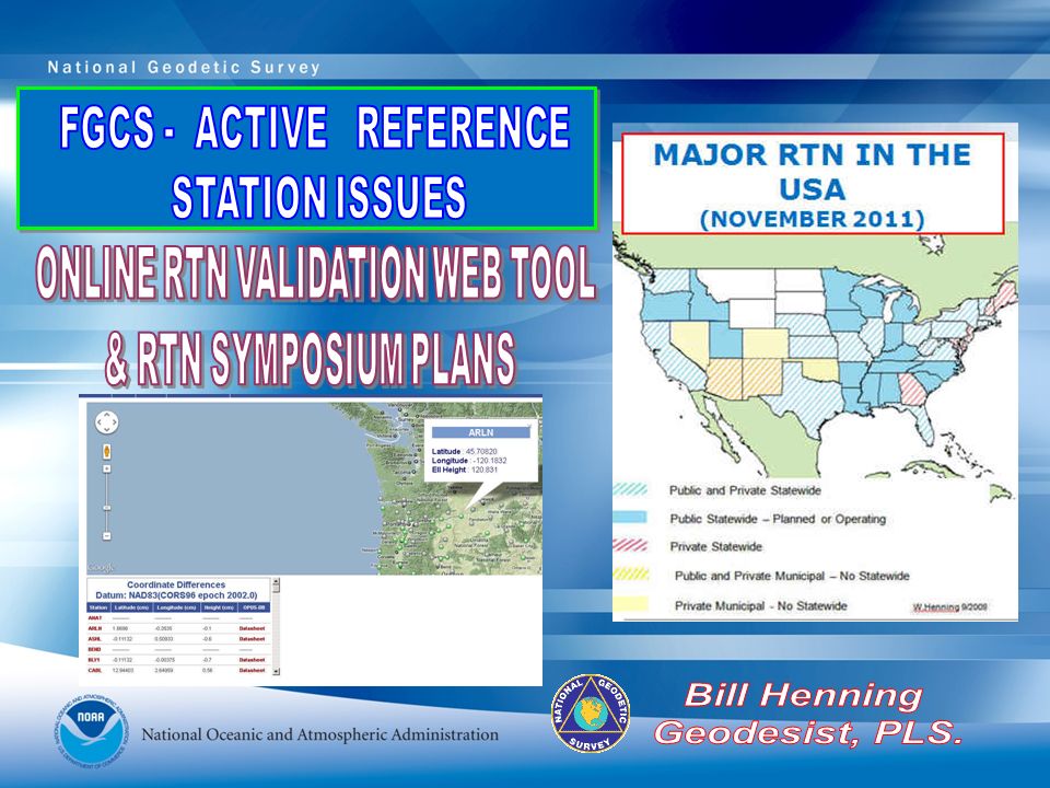
≥107 RTN USA ≥35 DOT ACADEMIC/SCIENTIFIC SPATIAL REFERENCE CENTERS VARIOUS DOTS + MACHINE GUIDANCE COUNTY CITY GEODETICSURVEYS(NC,SC) MANUFACTURERS VENDOR NETWORKS AGRICULTURE MA & PA NETWORKS MAJOR RTN IN THE USA (MAR 2011)
 MANUFACTURERS VENDOR NETWORKS AGRICULTURE MA & PA NETWORKS MAJOR RTN IN THE USA (MAR 2011)")
3
Active sites 1850+ 1250 used in NAD 83 (2011) CORS Network continued growth RTN AND NGS “FOUNDATION CORS” WILL BE THE PRIMARY ACCESS TO THE NSRS
 CORS Network continued growth RTN AND NGS FOUNDATION CORS WILL BE THE PRIMARY ACCESS TO THE NSRS")
4
2022 NEW PROJECT CONTROL – ACCESS TO NSRS NATIONAL CORS = GEOMETRICAL & GEOPOTENTIAL TRUTH RTN ALIGNED TO CORS AT 1 CM IN EACH COMPONENT (X,Y,Z) & 2 CM ORTHOMETRIC NEW PROJECT CONTROL FROM RTN OR OPUS EXISTING PASSIVE MARKS- HORIZONTAL WITH OR WITHOUT VERTICAL EXISTING PASSIVE BENCH MARKS 20 KM 200 KM (NOT TO SCALE) 70 KM (NOT TO SCALE)
 & 2 CM ORTHOMETRIC NEW PROJECT CONTROL FROM RTN OR OPUS EXISTING PASSIVE MARKS- HORIZONTAL WITH OR WITHOUT VERTICAL EXISTING PASSIVE BENCH MARKS 20 KM 200 KM (NOT TO SCALE) 70 KM (NOT TO SCALE)")
5
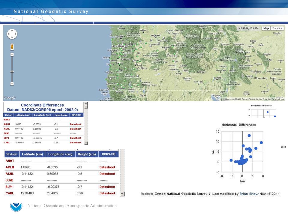
HOW WILL NGS VALIDATE RTN NSRS COMPLIANCE? 1. TOP DOWN: OPUS POSITIONS ON RTN REFERENCE STATIONS AT APPROPRIATE INTERVALS COULD PRODUCE GRAPHICS THAT WOULD SHOW BIASES AT A GLANCE. NGS ON- LINE TOOL “Develop guidelines for both the administration and use of real-time GNSS networks and especially for ensuring that these networks are compatible with the NSRS.” NGS 2011 STRATEGIC PLAN / 1.7 & 1.8: 2. USER UP: PHYSICAL MONUMENTATION, ESTABLISHED WITH BEST TECHNOLOGY, COULD BE USED AS FIDUCIAL STATIONS TO HELP THE USER VERIFY THAT RTN ARE PRODUCING ACCURATE COORDINATES,

6
ON-LINE VALIDATION TOOL CAN PROVIDE NSRS COMPLIANCE FOR RTN

8
OPERATIONAL PROTOTYPE SCORS – 19 STATIONS STREAMING GNSS OBSERVABLES IN RTCM 3.0 FORMAT

9
POSSIBLE FED PARTNERS: USCG ACOE NGA

10
NOTES FROM JULIANA AFTER THE JULY 2011 FGCS MEETING “First of all, a written "plan" must be drafted to address (for example): Policies that permit or prevent NGS/the feds from serving up this data Rationale for why this is important to the nation Robust tests on what is achievable from a positioning standpoint Specifics on who are the user groups - now and in the future Bandwidth requirements Infrastructure/spacing that would be ideal Impacts to existing/new RTNs Estimated costs to be considered NGS capacity to manage “
: Policies that permit or prevent NGS/the feds from serving up this data Rationale for why this is important to the nation Robust tests on what is achievable from a positioning standpoint Specifics on who are the user groups - now and in the future Bandwidth requirements Infrastructure/spacing that would be ideal Impacts to existing/new RTNs Estimated costs to be considered NGS capacity to manage")
11
SOME OMB A-130 VERBIAGE 7. Basic Considerations and Assumptions: “Government information is a valuable national resource.” “The free flow of information between the government and the public is essential to a democratic society. “ “The nation can benefit from government information disseminated both by Federal agencies and by diverse nonfederal parties, including State and local government agencies, educational and other not-for-profit institutions, and for-profit organizations.” “The open and efficient exchange of scientific and technical government information, subject to applicable national security controls and the proprietary rights of others, fosters excellence in scientific research and effective use of Federal research and development funds.” “Federal Government information resources management policies and activities can affect, and be affected by, the information policies and activities of other nations.” “Users of Federal information resources must have skills, knowledge, and training to manage information resources, enabling the Federal government to effectively serve the public through automated means. “The application of up-to-date information technology presents opportunities to promote fundamental changes in agency structures, work processes, and ways of interacting with the public that improve the effectiveness and efficiency of Federal agencies. “ “The availability of government information in diverse media, including electronic formats, permits agencies and the public greater flexibility in using the information” “Establish and maintain communications with members of the public and with State and local governments so that the agency creates information dissemination products that meet their respective needs; “

12
OMB A-130 8. How will agencies carry out electronic information dissemination? “Agencies will use electronic media and formats, including public networks, as appropriate and within budgetary constraints, in order to make government information more easily accessible and useful to the public.” 9 b. (ii) Ensure that decisions to improve existing information systems or develop new information systems are initiated only when no alternative private sector or governmental source can efficiently meet the need; 9 b. (ix) Ensure that improvements to existing information systems and the development of planned information systems do not unnecessarily duplicate IT capabilities within the same agency, from other agencies, or from the private sector;
 Ensure that decisions to improve existing information systems or develop new information systems are initiated only when no alternative private sector or governmental source can efficiently meet the need; 9 b. (ix) Ensure that improvements to existing information systems and the development of planned information systems do not unnecessarily duplicate IT capabilities within the same agency, from other agencies, or from the private sector;.")
13
SUMMARY: PIECES OF THE NGS SCORS PLAN MOST IMPORTANTLY: TAKE AWAY FROM THE RTN SYMPOSIUM WILL GUIDE OUR COURSE. USCG TESTING: FEDERAL PARTNERSHIP OF NDGPS DATA STREAM TESTS SHOWING BANDWIDTH REQUIREMENTS. COMPILE EXISTING POSITION PAPERS (INCLUDING RATIONALE) ALONG WITH THE APPROVED INTERNAL RT POLICY AND RESPONSES TO PREVIOUS POLLS. OMB CIRCULAR A-130: SLIGHTLY AMBIGUOUS BUT DOES SEEM TO SUPPORT SCORS CONCEPT. PRECEDENTS IN OTHER NATIONS. SHOW BENEFIT TO NEW & EXISTING RTN. ON LINE VALIDATION TOOL + INTERNAL PASSIVE MARKS = NSRS COMPLIANCE.
 ALONG WITH THE APPROVED INTERNAL RT POLICY AND RESPONSES TO PREVIOUS POLLS. OMB CIRCULAR A-130: SLIGHTLY AMBIGUOUS BUT DOES SEEM TO SUPPORT SCORS CONCEPT. PRECEDENTS IN OTHER NATIONS. SHOW BENEFIT TO NEW & EXISTING RTN. ON LINE VALIDATION TOOL + INTERNAL PASSIVE MARKS = NSRS COMPLIANCE..")
Similar presentations


: concept and results December 2007 Chisinau.>")


, and GEOID 12 in Alabama Overview of Height Modernization Project Overview of Height Modernization.>")


