Download presentation
Presentation is loading. Please wait.

1
World geography Nov. 25, 2014

2
Remaining schedule Unit 8 – Urban Geography Unit 9 – Industry and Services Unit 10 – Human Environment

3
Last Tuesday Yeungdae Kmuland Kaclandia

4
Questions - What is this state’s major industry? - How dependent is the new state on its former colonizer (France) - Does Kaclandia have natural resources. If so, where are they located? - What is Kaclandia’s population? What are its demographics (especially its labor force)? - Does the new state plan on building new religious structures?
 - Does Kaclandia have natural resources. If so, where are they located - What is Kaclandia’s population What are its demographics (especially its labor force) - Does the new state plan on building new religious structures")
5
Today Unit 8 (Urban Geography)
")
6
Some basic terms City: A conglomeration of people and buildings clustered together to serve as a center of politics, culture, and economics Urban: The buildup of the city and surrounding environs connected to the city (central city and suburbs) Urbanization: Movement of people from rural to urban areas—can happen very quickly in the modern world
 Urbanization: Movement of people from rural to urban areas—can happen very quickly in the modern world")
7
Global Urban Population

8
Australia

9
Where are cities located and why?
Site Absolute location Static location, often chosen for trade, defense, or religion Situation Relative location A city’s place in the region and the world around it Trade area: An adjacent region within which a city’s influence is dominant

10
Trade Areas

11
Rank-size rule Characteristic of a model urban hierarchy
The population of the city or town is inversely proportional to its rank in the hierarchy For example: largest city = 12 million 2nd largest = 6 million 3rd largest = 4 million 4th largest = 3 million
![]()
12
Primate city The leading city of a country, disproportionately larger than the rest of the cities Factors affecting primate cities: - spread of colonialism - strong centralized government - economic factors - rural-urban migration - efficiency of modern transport

13
Advantages of primate cities
- Economies of large scale can be achieved because these cities attract overseas investment and benefits that can benefit the entire country/state. - Attractive places of migration. - Resources, services, and infrastructure available on a large scale.

14
Problems faced by primate cities
- housing shortages - traffic congestion - crime - pollution - increase in land value (unaffordable housing) - imbalance in development
 - imbalance in development.")
15
Primate cities - examples
- France: Paris (popn. 9.6 million) Marseilles, France’s next largest city (popn. 1.3 million) - U.K.: London (popn. 7 million) Next largest city (Birmingham) popn. 1 million. - South Korea: Seoul (popn. 10 million) % of the country’s population.
 Marseilles, France’s next largest city (popn. 1.3 million) - U.K.: London (popn. 7 million) Next largest city (Birmingham) popn. 1 million. - South Korea: Seoul (popn. 10 million) 20% of the country’s population.")
16
Countries without primate cities
- India: Most populous city = Mumbai (16 million) second most populous: Kolkata (13 million) - China, Canada, Australia, Brazil, U.S.
 second most populous: Kolkata (13 million) - China, Canada, Australia, Brazil, U.S.")
17
Central Place Theory (Christaller)
- Predicts how and where central places in the urban hierarchy (hamlets, villages, towns, and cities) are functionally and spatially distributed - Assumes that Surface is flat with no physical barriers Soil fertility is the same everywhere Population and purchasing power are evenly distributed Region has uniform transportation network From any given place, a good or service could be sold in all directions out to a certain distance
 are functionally and spatially distributed. - Assumes that. Surface is flat with no physical barriers. Soil fertility is the same everywhere. Population and purchasing power are evenly distributed. Region has uniform transportation network. From any given place, a good or service could be sold in all directions out to a certain distance.")
18
Hexagonal Hinterlands
C = city T = town V = village H = hamlet

20
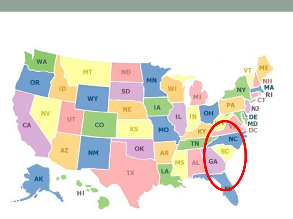
Georgia, N. Carolina, S. Carolina

21
Organization of Cities and how Cities Function
Urban morphology: The layout of a city, its physical form and structure Functional zonation: The division of the city into certain regions (zones) for certain functions (purposes)
 for certain functions (purposes)")
22
Zones of a city Zones - Central business district (CBD)
- Central City (the CBD + older housing zones) - Suburb (outlying, functionally uniform zone outside of the central city)
 - Suburb (outlying, functionally uniform zone outside of the central city)")
23
Zones of a city

24
Zones of a city

25
Zones of a city

26
Zones of a city Modeling the North American city - Concentric zone model (Ernest Burgess) - Sector model (Homer Hoyt) - Multiple-nuclei model (Chauncy Harris and Edward Ullman)
 - Sector model (Homer Hoyt) - Multiple-nuclei model (Chauncy Harris and Edward Ullman)")
27
Classical models of urban structure

28
Edge cities Suburban downtowns, often located near key freeway intersections, including - Office complexes - Shopping centers - Hotels - Restaurants - Entertainment facilities - Sports complexes

29
Urban Realms model Each realm a separate economic, social, and political entity that is linked together to form a larger metropolitan framework

30
Satellite cities Seoul Capital Area

31
Satellite cities Example: Seoul Capital Area (Sudogwon) - Central city is Seoul (“Seoul Special City”) Satellite cities include: - Incheon - Suwon - Ansan - Anyang - Goyang - Seongnam - Bucheon - Yongin The Seoul Capital Area is the world’s second largest metropolitan area popn. 25,000,000
 - Central city is Seoul ( Seoul Special City ) Satellite cities include: - Incheon - Suwon - Ansan - Anyang - Goyang - Seongnam - Bucheon - Yongin. The Seoul Capital Area is the world’s second largest metropolitan area popn. 25,000,000.")
32
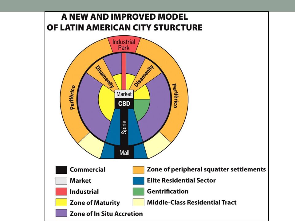
Cities of periphery and semi-periphery
Latin America

33
Cities of periphery and semi-periphery
Griffin-Ford model Blend of Latin American traditions with globalization Disamenity sectors Not connected to city services May be controlled by gangs and drug lords Industrial park Gentrification area

35
Example: Rio De Janeiro (Brazil)
")
36
Industrial park

37
Cities of periphery and semi-periphery
Subsaharan Africa De Blij model - Low levels of urbanization but rapid growth rates - European colonial imprint

38
Nairobi, Kenya

39
Accra, Ghana

40
Abidjan, Ivory Coast

41
Cape Town, South Africa

42
Satellite township: Cape Town

43
Cities of periphery and semi-periphery
McGee model - Colonial port and surrounding commercial zone as focal point

44
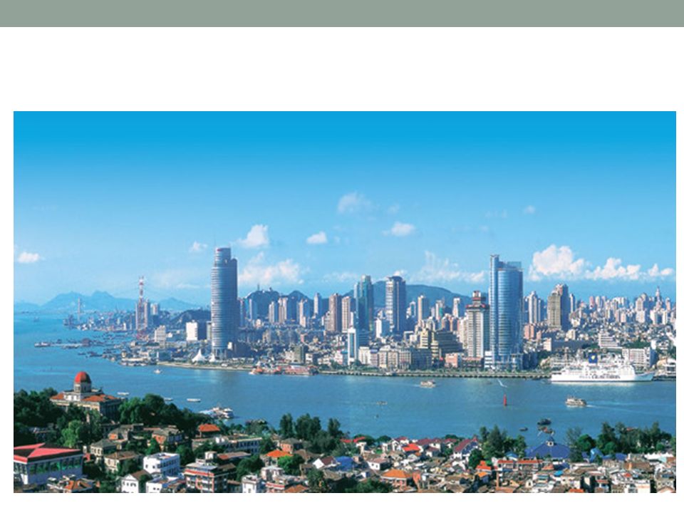
Functional zonation – real-life example
Xiamen

47
How people make cities Role of powerful social and cultural forces Periphery and semi-periphery: - Sharp contrast between rich and poor - Often lack zoning laws or enforcement of zoning laws

48
Making cities in the core (U.S.)
Redlining: Financial institutions refusing to lend money in certain neighborhoods Blockbusting : Realtors purposefully selling a home at a low price to an African American and then soliciting white residents to sell their homes at low prices, to generate “white flight”

49
Making cities in the core (U.S.)
Gentrification: Individuals buying and rehabilitating houses, raising the housing value in the neighborhood

50
Gentrification (Harlem, New York)
")
51
Gentrification (Harlem, New York)
")
52
Gentrification (Harlem, New York)
")
53
Making cities in the core (U.S.)
Commercialization: City government transforming a central city to attract residents and tourists, often in stark contrast to the rest of the central city

54
Making cities in the core (U.S.)
Tear-downs: Houses that new owners buy with the intention of tearing them down to build much larger homes McMansions: Large homes, often built to the outer limits of the lot

55
Mcmansions

56
Mcmansions

57
Mcmansions

58
Making cities in the core (U.S.)
Urban Sprawl: Unrestricted growth of housing, commercial developments, and roads over large expanses of land, with little concern for urban planning

59
Making cities in the core (U.S.)
Urban Sprawl:

60
New Urbanism Development, urban revitalization, and suburban reforms that create walkable neighborhoods with a diversity of housing and jobs Concerns: - Privatization of public spaces - Failure to address conditions that create social ills of cities - Countering urban sprawl

61
New Urbanism

63
Next Class - Wrap up Unit 8 - Introduce Unit 9 (Industries and Services)
")
Similar presentations