Download presentation
Presentation is loading. Please wait.

1
Institute of Hydrology Slovak Academy of Sciences Katarína Stehlová 6 th ALPS-ADRIA SCIENTIFIC WORKSHOP 30 April - 5 May, 2007 Obervellach, Austria Assessment of the soil water storage with regard to prognosis of the climate change at lowlands

2
Climate change influence of hydrological cycle increase of intense precipitation increase of thunderstorms and local floods decrease of water resources increase of temperature increase of drought and wild fire events...

3
Map of the locality of interest Soil profile in locality Bodiky 0-120 cm is loamy or sandy loam, 120-150 cm is sandy layer, under 150 is cm gravel.

4
Mathematical model GLOBAL The model was created by Dr. Juraj Majercak and Dr. Viliam Novak from Institute of Hydrology, Slovakia, Bratislava. This model belongs to the group of one-dimensional vertical models and on basic Richards’s equation simulates the move of water in the system soil – vegetation – atmosphere in isothermal condition with especial regard on the root zone.

5
Initial moisture profile: Lower boundary condition: time series of values of pressure head in the depth of 150 cm under soil surface. Upper boundary condition: daily values of crop parameters (leaf area index [m 2.m -2 ], roughness of evaporating surface [m], albedo of surface [cm], root depth [cm] and relative mean water content [%]), Hydro-physical parameters of the soil profile divided into five layers at locality Bodiky, where s is saturated moisture, pk is field water capacity, r is residual moisture, and n are Genuchten’s parameters and C is saturated hydraulic conductivity
, Hydro-physical parameters of the soil profile divided into five layers at locality Bodiky, where s is saturated moisture, pk is field water capacity, r is residual moisture, and n are Genuchten’s parameters and C is saturated hydraulic conductivity.")
6
climatic characteristics measured on the meteorological gauge station of Slovak Hydro-Meteorological Institute in Gabcikovo (daily precipitation total [mm.d -1 ], mean temperature [°C], sunshine duration [hours], vapor pressure [hPa] and mean wind velocity [m.s -1 ]). Climate characteristics for time horizon 2010 were modified by climate scenarios: CCCM2000 (Canadian Centre for Climate Modelling and Analysis, Victoria, British Columbia) GISS98 (Goddard Institute for Space Studies, New York, U.S.A)
![ climatic characteristics measured on the meteorological gauge station of Slovak Hydro-Meteorological Institute in Gabcikovo (daily precipitation total [mm.d -1 ], mean temperature [°C], sunshine duration [hours], vapor pressure [hPa] and mean wind velocity [m.s -1 ]).](http://images.slideplayer.com/34/8284985/slides/slide_6.jpg "Climate characteristics for time horizon 2010 were modified by climate scenarios: CCCM2000 (Canadian Centre for Climate Modelling and Analysis, Victoria, British Columbia) GISS98 (Goddard Institute for Space Studies, New York, U.S.A).")
7
Mean long-term temperature calculated for reference period 1955-84 and for horizon 2010 (CCCM2000, GISS98)
")
8
Mean long-term precipitation totals calculated for reference period 1955-84 and for horizon 2010 (CCCM2000, GISS98)
")
9
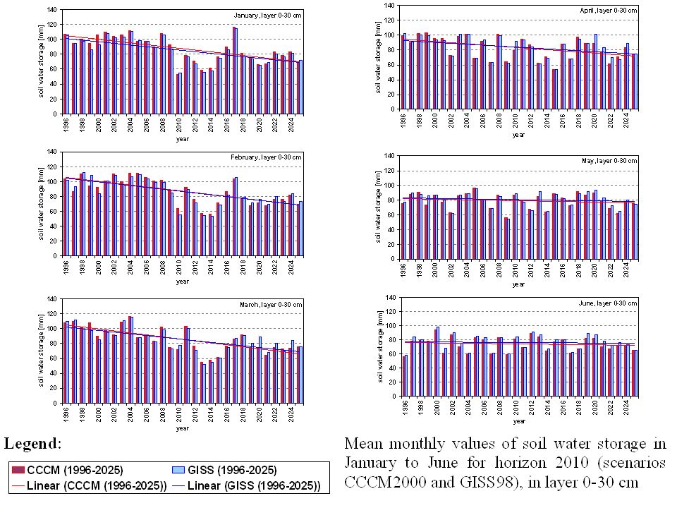
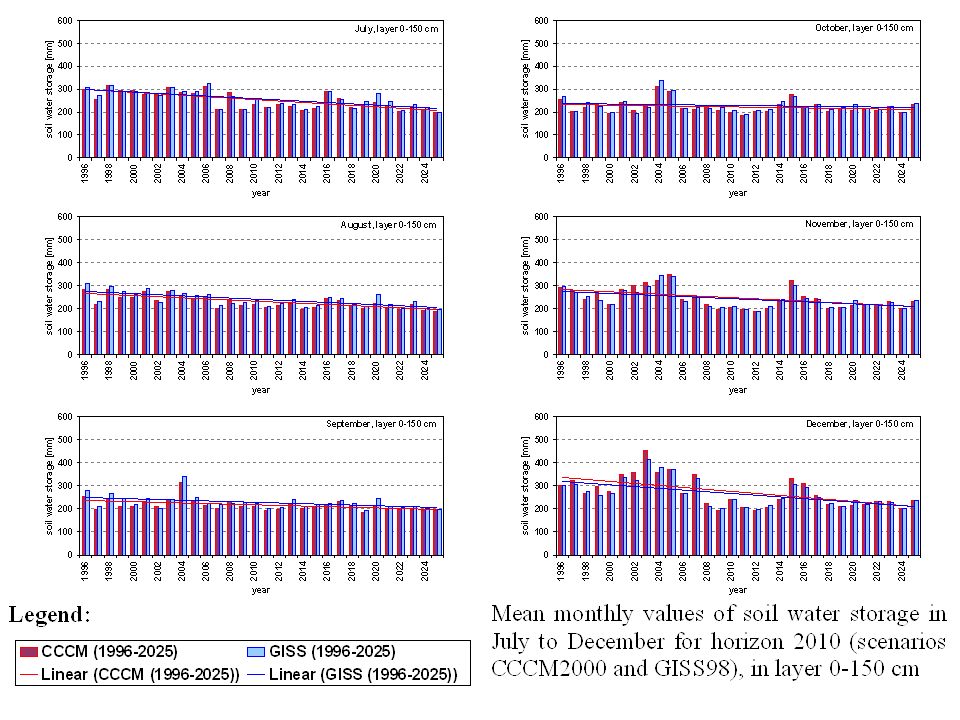
Results 30-years average monthly soil water storage [mm] in the reference period 1955-84 (RP), average monthly soil water storage [mm] in according to climate scenarios CCCM2000 (C) and GISS98 (G) for time horizon 2010
![Results 30-years average monthly soil water storage [mm] in the reference period (RP), average monthly soil water storage [mm] in according to climate scenarios CCCM2000 (C) and GISS98 (G) for time horizon 2010](http://images.slideplayer.com/34/8284985/slides/slide_9.jpg "Results 30-years average monthly soil water storage [mm] in the reference period (RP), average monthly soil water storage [mm] in according to climate scenarios CCCM2000 (C) and GISS98 (G) for time horizon 2010")
10
Differences of long-term averages of soil water storage [cm] modeled according to climate scenarios CCCM2000, GISS98 for time horizon 2010 and values modeled for reference period (1955-84) Percentage differences of long-term averages of soil water storage [cm] modeled according to climate scenarios CCCM2000, GISS98 for time horizon 2010 and values modeled for reference period (1955-84)
![Differences of long-term averages of soil water storage [cm] modeled according to climate scenarios CCCM2000, GISS98 for time horizon 2010 and values modeled for reference period ( ) Percentage differences of long-term averages of soil water storage [cm] modeled according to climate scenarios CCCM2000, GISS98 for time horizon 2010 and values modeled for reference period ( )](http://images.slideplayer.com/34/8284985/slides/slide_10.jpg "Differences of long-term averages of soil water storage [cm] modeled according to climate scenarios CCCM2000, GISS98 for time horizon 2010 and values modeled for reference period ( ) Percentage differences of long-term averages of soil water storage [cm] modeled according to climate scenarios CCCM2000, GISS98 for time horizon 2010 and values modeled for reference period ( )")
15
Conclusion The amounts of soil water content available for vegetation is one of the most necessary conditions for good vegetation grow. For the average monthly climatic values in accordance with scenario CCCM gave the model GLOBAL nearly in all months of counted time horizon 2010 lower values of soil water storage then for values adapted by scenario GISS. The decrease of soil water storage is prognosticated especially in the end of vegetation period. The mean monthly values (CCCM) in layers 0-30 cm, 31-60 cm and in whole soil profile 0-150 cm dropped about 1-7 % in comparison to reference period values. The values of soil water storage calculated by model GLOBAL with climatic values in accordance with scenario GISS decreased only about 1 % in comparison to reference period values. Since the upper layer 0-30 cm is most influenced by meteorological components, the soil water storage decrease in this layer is the most noticeable.
 in layers 0-30 cm, cm and in whole soil profile cm dropped about 1-7 % in comparison to reference period values. The values of soil water storage calculated by model GLOBAL with climatic values in accordance with scenario GISS decreased only about 1 % in comparison to reference period values. Since the upper layer 0-30 cm is most influenced by meteorological components, the soil water storage decrease in this layer is the most noticeable..")
16
Thank you for your attention...

Similar presentations


 Park, Professor Dept. of Civil and Environmental Engineering University of Wisconsin-Madison.>")


. Review of last lecture Components of global water cycle Ocean water Land soil moisture, rivers, snow cover, ice sheet and glaciers.>")


 Müncheberg, Germany Institute of Landscape Systems Analysis Funded by Martina Puhlmann, Hubert.>")


>")


