Download presentation
Presentation is loading. Please wait.

1
Positioning America for the Future NATIONAL OCEANIC AND ATMOSPHERIC ADMINISTRATION National Ocean Service National Geodetic Survey GPS Products & Services From NOAA’s National Geodetic Survey Richard Snay National Geodetic Survey 43rd CGSIC Meeting Arlington, VA March 11, 2004

2
Positioning America for the Future NATIONAL OCEANIC AND ATMOSPHERIC ADMINISTRATION National Ocean Service National Geodetic Survey Everyone is able to know where they are and where other things are anytime, anyplace!

3
Positioning America for the Future NATIONAL OCEANIC AND ATMOSPHERIC ADMINISTRATION National Ocean Service National Geodetic Survey NGS Products & Services * Continuously Operating Reference Stations (CORS) * GPS Satellite Orbits * GPS Antenna Calibration * Online Positioning User Service (OPUS)
 * GPS Satellite Orbits * GPS Antenna Calibration * Online Positioning User Service (OPUS)")
4
Positioning America for the Future NATIONAL OCEANIC AND ATMOSPHERIC ADMINISTRATION National Ocean Service National Geodetic Survey Continuously Operating Reference Stations

5
Regional CORS Coverage

6
CORS SITES

8
Positioning America for the Future NATIONAL OCEANIC AND ATMOSPHERIC ADMINISTRATION National Ocean Service National Geodetic Survey CORS OVERVIEW Network contained 800+ sites as of Feb. 2004 Growing at rate of 8 sites per month More than 110 organizations participate in the CORS program Provides code range (C/A, P1, P2) –and carrier phase observations (L1, L2) Provides meteorological data at some sites
 –and carrier phase observations (L1, L2) Provides meteorological data at some sites.")
9
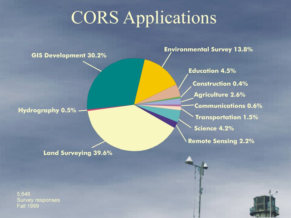
Positioning America for the Future NATIONAL OCEANIC AND ATMOSPHERIC ADMINISTRATION National Ocean Service National Geodetic Survey CORS APPLICATIONS Postmission Static Positioning (cm-level accuracy with a few hours of data, dm-level accuracy with one minute of data) Postmission Kinematic Positioning (dm-level accuracy for an aircraft, a boat, or a land vehicle) Geophysics / Crustal Motion Meteorology / Water Vapor in Atmosphere Space Weather / Free Electrons in Ionosphere
 Postmission Kinematic Positioning (dm-level accuracy for an aircraft, a boat, or a land vehicle) Geophysics / Crustal Motion Meteorology / Water Vapor in Atmosphere Space Weather / Free Electrons in Ionosphere")
10
Positioning America for the Future NATIONAL OCEANIC AND ATMOSPHERIC ADMINISTRATION National Ocean Service National Geodetic Survey NATIONAL CORS NETWORK National CORS network contains 453 sites whose data are available directly from NOAA’s National Geodetic Survey in Silver Spring, MD GPS and “met” data stored in RINEX format Data made available to public via: –World Wide Web –File transfer protocol Currently 10 years of CORS data are online for immediate access Parallel CORS Data Site being established at NOAA’s National Geophysical Data Center in Boulder, CO

11
Positioning America for the Future NATIONAL OCEANIC AND ATMOSPHERIC ADMINISTRATION National Ocean Service National Geodetic Survey

12
aaaaaaaaaaaaaaaa CORS PARTNERS: FEDERAL Federal Highway Administration Federal Railroad Administration Federal Aviation Administration Forecast Systems Laboratory National Geophysical Data Center Space Environment Center NASA US Army Corps of Engineers US Air Force US Naval Observatory US Geological Survey

13
CORS PARTNERS: STATES California Spatial Reference Center Louisiana Spatial Reference Center

14
Positioning America for the Future NATIONAL OCEANIC AND ATMOSPHERIC ADMINISTRATION National Ocean Service National Geodetic Survey CORS PARTNERS: SCIENTIFIC PANGA BARD SCIGN BARGN EBRY BAYONET International GPS Service (IGS) University Navstar Consortium (UNAVCO) Scripps Orbit & Permanent Array Center Plate Boundary Observatory SuomiNet
 University Navstar Consortium (UNAVCO) Scripps Orbit & Permanent Array Center Plate Boundary Observatory SuomiNet")
15
Positioning America for the Future NATIONAL OCEANIC AND ATMOSPHERIC ADMINISTRATION National Ocean Service National Geodetic Survey CORS PARTNERS: INTERNATIONAL Guatemala El Salvador Honduras Nicaragua Mexico Jamaica Canada International Earth Rotation Service (IERS) International GPS Service (IGS)
 International GPS Service (IGS)")
16
Positioning America for the Future NATIONAL OCEANIC AND ATMOSPHERIC ADMINISTRATION National Ocean Service National Geodetic Survey CORS Partners: Private Industry “ If you want to see where GPS is going, then keep your eye on the GPS manufacturers.” Bill Strange Former Manager National CORS Program Many GPS companies have developed software that provides their customers with automatic access to CORS data for postprocessing activities.

18
Positioning America for the Future NATIONAL OCEANIC AND ATMOSPHERIC ADMINISTRATION National Ocean Service National Geodetic Survey LIDAR images of Manhattan before and after 11 SEP 2001 CORS data used to position aircraft These images are computerized visualizations of elevation information of the World Trade Center from before (July 2000) and after (September 15, 2001) the attack. These maps were produced using an airborne LIDAR (Light Detection and Ranging) system. The LIDAR system creates detailed and highly accurate elevation information by the precise timing of thousands of laser pulses striking the ground surface. These data can be manipulated in the digital environment to create an array of maps and views of the project site and to obtain precise measuresments of structures, debris fields, and other vital information. These images were generated by EarthData (www.earthdata.com), and the aircraft was positioned using CORS data from the NJI2 site which is operated by the New Jersey Institute of Technology.
 system. The LIDAR system creates detailed and highly accurate elevation information by the precise timing of thousands of laser pulses striking the ground surface. These data can be manipulated in the digital environment to create an array of maps and views of the project site and to obtain precise measuresments of structures, debris fields, and other vital information. These images were generated by EarthData ( and the aircraft was positioned using CORS data from the NJI2 site which is operated by the New Jersey Institute of Technology..")
19
Positioning America for the Future NATIONAL OCEANIC AND ATMOSPHERIC ADMINISTRATION National Ocean Service National Geodetic Survey Horizontal velocities relative to “stable” sites Points with more than 3 yrs of data

20
GPS ORBIT DETERMINATION Positioning America for the Future NATIONAL OCEANIC AND ATMOSPHERIC ADMINISTRATION National Ocean Service National Geodetic Survey

21
Positioning America for the Future NATIONAL OCEANIC AND ATMOSPHERIC ADMINISTRATION National Ocean Service National Geodetic Survey NGS ORBIT PRODUCTS I. Constrained Precise GPS Orbit: Up to 99 constrained IGS fiducial tracking sites in the IGb00, epoch 1998.0 reference frame Available – 3 to 6 days from the date of observation Contact – http://www.ngs.noaa.gov/GPS/NGSorbs /precise Accuracy – approximately 3 - 6 centimeters

22
Positioning America for the Future NATIONAL OCEANIC AND ATMOSPHERIC ADMINISTRATION National Ocean Service National Geodetic Survey NGS ORBIT PRODUCTS (CONTINUED) III. Rapid GPS Orbit: Up to 99 constrained IGS fiducial tracking sites in the IGb00, epoch 1998.0 reference frame Available – 16 hours from last observation Contact – ftp://www.ngs.noaa.gov/cors/orbits/rapid Accuracy – approximately 4 - 7 centimeters

23
Positioning America for the Future NATIONAL OCEANIC AND ATMOSPHERIC ADMINISTRATION National Ocean Service National Geodetic Survey NGS ORBIT PRODUCTS (CONTINUED) IV. Ultra-Rapid GPS Orbit: A constrained estimated/predicted solution in the IGb00, epoch 1998.0 reference frame Available – within 2 to 3 hours from last observation Contact – under development Accuracy – approximately 20 - 40 centimeters

24
Positioning America for the Future NATIONAL OCEANIC AND ATMOSPHERIC ADMINISTRATION National Ocean Service National Geodetic Survey Positioning America for the Future NATIONAL OCEANIC AND ATMOSPHERIC ADMINISTRATION National Ocean Service National Geodetic Survey

25
Positioning America for the Future NATIONAL OCEANIC AND ATMOSPHERIC ADMINISTRATION National Ocean Service National Geodetic Survey International GPS Service Trivia Founded in 1993 Currently 8 contributing analysis centers Organized Global Data Centers (over 360 fiducial tracking sites, Site information logs) Continuously tracking Dual - frequency High quality clocks Internet accessibility Accurate coordinates in the most current ITRF Web Site – http://igscb.jpl.nasa.gov
 Continuously tracking Dual - frequency High quality clocks Internet accessibility Accurate coordinates in the most current ITRF Web Site –")
26
Positioning America for the Future NATIONAL OCEANIC AND ATMOSPHERIC ADMINISTRATION National Ocean Service National Geodetic Survey International GPS Service Trivia Combination Products Orbits Satellite and station clock information Tropospheric information Earth Rotation Parameters (CONTINUED) IGS Tracking Station Coordinates and Velocities
 IGS Tracking Station Coordinates and Velocities")
27
Positioning America for the Future NATIONAL OCEANIC AND ATMOSPHERIC ADMINISTRATION National Ocean Service National Geodetic Survey IGS Fiducial Site Coverage

28
Positioning America for the Future NATIONAL OCEANIC AND ATMOSPHERIC ADMINISTRATION National Ocean Service National Geodetic Survey

29
Positioning America for the Future NATIONAL OCEANIC AND ATMOSPHERIC ADMINISTRATION National Ocean Service National Geodetic Survey Antenna Calibration Facility in Corbin, Virginia

30
Positioning America for the Future NATIONAL OCEANIC AND ATMOSPHERIC ADMINISTRATION National Ocean Service National Geodetic Survey WHY DO I NEED THE ANTENNA TYPE? The antenna phase centers are located somewhere around here. The Antenna Reference Point (ARP) is almost always located in the center of the bottom surface of the antenna. The antenna offsets are the distance between the phase centers and the ARP If the user selects NONE as the antenna type, the offsets are set to 0.000 and the antenna phase center becomes the reference You do not need to know these offsets. They are passed to the processing software through the antenna type Incorrect or missing antenna type big vertical errors
 is almost always located in the center of the bottom surface of the antenna. The antenna offsets are the distance between the phase centers and the ARP If the user selects NONE as the antenna type, the offsets are set to and the antenna phase center becomes the reference You do not need to know these offsets. They are passed to the processing software through the antenna type Incorrect or missing antenna type big vertical errors.")
31
Positioning America for the Future NATIONAL OCEANIC AND ATMOSPHERIC ADMINISTRATION National Ocean Service National Geodetic Survey Note that SV elevation and varying phase patterns affect signal interpretation differently........................ SV 14 SV 20 Antenna Type A Antenna Type B Antenna Phase Center Variation

32
Positioning America for the Future NATIONAL OCEANIC AND ATMOSPHERIC ADMINISTRATION National Ocean Service National Geodetic Survey........................ SV 14 SV 20 Antenna Type A Antenna Type B Different Phase Patterns Note that SV elevation and varying phase patterns affect signal interpretation differently Antenna Phase Center Variation

33
Positioning America for the Future NATIONAL OCEANIC AND ATMOSPHERIC ADMINISTRATION National Ocean Service National Geodetic Survey ELECTRONIC PHASE CENTER Elevation Angle (deg.) Phase Center Variation (mm)
 Phase Center Variation (mm)")
34
Positioning America for the Future NATIONAL OCEANIC AND ATMOSPHERIC ADMINISTRATION National Ocean Service National Geodetic Survey WHAT IS OPUS? On-line Positioning User Service Provide GPS users faster & easier access to the National Spatial Reference System (NSRS)
.")
35
Positioning America for the Future NATIONAL OCEANIC AND ATMOSPHERIC ADMINISTRATION National Ocean Service National Geodetic Survey HOW DOES OPUS WORK? Submit RINEX file through NGS web page Processed automatically with NGS computers & software With respect to 3 suitable National CORS Solution via email (usually in minutes)
.")
36
Positioning America for the Future NATIONAL OCEANIC AND ATMOSPHERIC ADMINISTRATION National Ocean Service National Geodetic Survey OPUS USES 3 CORS SITES

37
Positioning America for the Future NATIONAL OCEANIC AND ATMOSPHERIC ADMINISTRATION National Ocean Service National Geodetic Survey Vertical Precision Using Dual-Frequency GPS Carrier Phase Observations 95% Confidence Level

Similar presentations

>")


 Scripps Orbit.>")
 & Geographic Information Systems (GIS) RESOURCE INVENTORY Soil Survey National Resources Inventory (NRI) Wetlands.>")


 work>")

 System Richard Snay NOAA’s National Geodetic Survey Corbin, Virginia June 2008.>")

 status and plans Improved solutions for simultaneous or repeated observations harvest data from multiple observers share upload &>")


 Working Group Mike Craymer Geodetic Survey Division, Natural Resources Canada 2nd SNARF Workshop Montreal, May.>")