Download presentation
Presentation is loading. Please wait.

1
National Integrated Drought Information System Drought Early Warning for the Apalachicola- Chattahoochee-Flint River Basin 14 October 2014

2
Outline Welcome – Eric Reutebuch, AU Water Resources Center Current drought status – David Zierden, Florida Climate Center, FSU Streamflows and groundwater – Tony Gotvald, USGS Seasonal forecasts and outlooks – David Zierden, FSU Streamflow forecasts – Jeff Dobur, SERFC Summary and Discussion

3
Current drought status David Zierden

4
October Drying Welcome

5
Vigorous Low Pressure System

6
7-day Rainfall Totals

7
Lawn and Garden Moisture Index

8
30-Day Rainfall

9
90-day Rainfall Departures

11
Realtime stream flow compared with historical monthly averages Current: http://waterwatch.usgs.gov Previous Brief: Tony Gotvald

12
Below Normal 7-day Average Streamflows Below normal 7-day average streamflow as compared with historical streamflow for day shown http://waterwatch.usgs.gov Current: Previous brief:

13
Lake Lanier Inflows http://waterwatch.usgs.gov Chattahoochee near Cornelia (02331600) Chestatee near Dahlonega (02333500)
 Chestatee near Dahlonega ( )")
14
Current Streamflows http://waterwatch.usgs.gov Chattahoochee at Atlanta (02336000) Chattahoochee near Whitesburg (02338000)
 Chattahoochee near Whitesburg ( )")
15
Current Streamflows Chattahoochee at West Point (02339500) Chattahoochee at Columbus(02341460) http://waterwatch.usgs.gov
 Chattahoochee at Columbus( )")
16
Current Streamflows Flint River near Griffin (02344500) Flint River near Carsonville (02347500) http://waterwatch.usgs.gov
 Flint River near Carsonville ( )")
17
Current Streamflows Flint River at Albany (02352500) Flint at Bainbridge (02356000) http://waterwatch.usgs.gov
 Flint at Bainbridge ( )")
18
Streamflows Apalachicola at Chattahoochee (02358000) http://waterwatch.usgs.gov
")
19
Groundwater Conditions http://groundwaterwatch.usgs.gov Previous briefCurrent brief

20
Groundwater Status – Miller County 08G001 (Upper Floridan Aquifer)
")
21
Groundwater Status – Seminole County 06F001 (Upper Floridan Aquifer)
")
22
Groundwater Status – Early County 08K001 (Upper Floridan Aquifer)
")
24
7-Day Precipitation Forecast http://www.hpc.ncep.noaa.gov/qpf/day1-5.shtml David Zierden

25
7-day average Pacific Ocean SST Anomalies

26
Nino Indices

27
Multivariate ENSO Index

28
Winds Over the Pacific

29
Subsurface Temperatures Late AprilCurrent

30
ENSO Model Forecast

31
1-3 Month Precipitation Outlook 1 Month 3 Month

32
Other Signs of El Nino Dry summer in the Southeast Inactive Atlantic hurricane season Very active E. Pacific hurricane season Active SW Monsoon NOAA forecast 65% Australia BOM 50% Klaus Wolter 80-90% Tallahassee recorded the driest summer ever at 8.66 inches

33
October Hurricane Tracks

34
Florida Hurricane Drought

35
Summer Rainfall Climatology

36
U.S. Drought Outlook

38
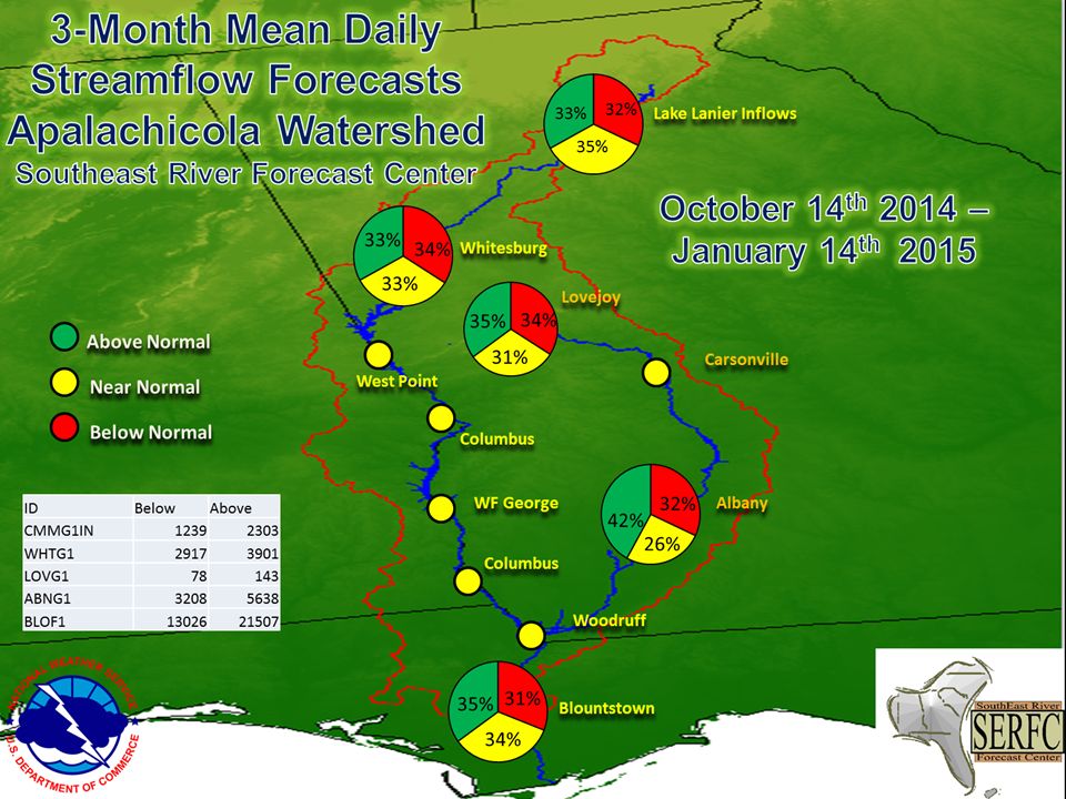
Above Normal Near Normal Below Normal Lake Lanier Inflows Whitesburg West Point Columbus WF George Columbus Woodruff Blountstown Lovejoy Carsonville Albany Jeff Dobur

41
Severe drought hanging on in South Georgia, significant improvement over the entire area anticipated. Ongoing event brings 30-day totals up to normal. 90-day totals are mixed in the middle and upper basin, still below normal in the lower ACF 10-day dry period was well-timed for row crop harvest (peanut, cotton, corn) Development of El Nino is now very late, but weak event still possible. E. Pacific hurricane season and Southeast Summer dryness could be signs Inactive Atlantic hurricane season continues Climatologically can only expect 2-3” in October, more in November. Summary-David Zierden
 Development of El Nino is now very late, but weak event still possible. E. Pacific hurricane season and Southeast Summer dryness could be signs Inactive Atlantic hurricane season continues Climatologically can only expect 2-3 in October, more in November. Summary-David Zierden.")
42
Summary-Tony Gotvald Realtime streamflows are in the normal to below normal range throughout the ACF basin. Inflows into Lake Lanier are in the below normal range. Streamflows are below normal throughout the Flint River basin. Groundwater levels are in the normal range in Southwest Georgia

43
Summary-Jeff Dobur 1 Month Streamflow forecast - Near Normal 3 Month Streamflow forecast – Near Normal, nearly equal chances at all 3 categories Not much change from previous forecast

44
Questions, Comments, Discussion

45
References Speakers David Zierden, FSU Tony Gotvald, USGS Jeff Dobur, SERFC Moderator Eric Reutebuch, AU WRC Additional information General drought information http://drought.gov http://www.drought.unl.edu General climate and El Niño information http://agroclimate.org/climate/ http://agroclimate.org/climate/ Streamflow monitoring & forecasting http://waterwatch.usgs.gov http://www.srh.noaa.gov/serfc/ Groundwater monitoring http://groundwaterwatch.usgs.gov

46
Thank you! Next briefing November 18, 2014 November 18, 2014, 1:00 pm EDT Moderator: Eric Reutebuch Slides from this briefing will be posted at http://drought.gov/drought/content/regional-programs/regional-drought-webinars Please send comments and suggestions to: reuteem@auburn.edu

Similar presentations


 September 2008 summary: Congress has made little progress on the federal.>")


 Winter Weather Forecast Conference OMSI / Oregon Chapter of the AMS 29 October 2011 Winter Weather Forecast Conference OMSI.>")


