Download presentation
Presentation is loading. Please wait.

1
An Integrated Systems Solution to Air Quality Data and Decision Support on the Web GEO Architecture Implementation Pilot – Phase 2 (AIP-2) Kickoff Workshop NCAR Mesa Laboratory, Boulder, Colorado September 25-26, 2008 AIP Phase 2 Call For Participation: VIEWS/TSS Response Overview
 Kickoff Workshop NCAR Mesa Laboratory, Boulder, Colorado September 25-26, 2008 AIP Phase 2 Call For Participation: VIEWS/TSS Response Overview")
2
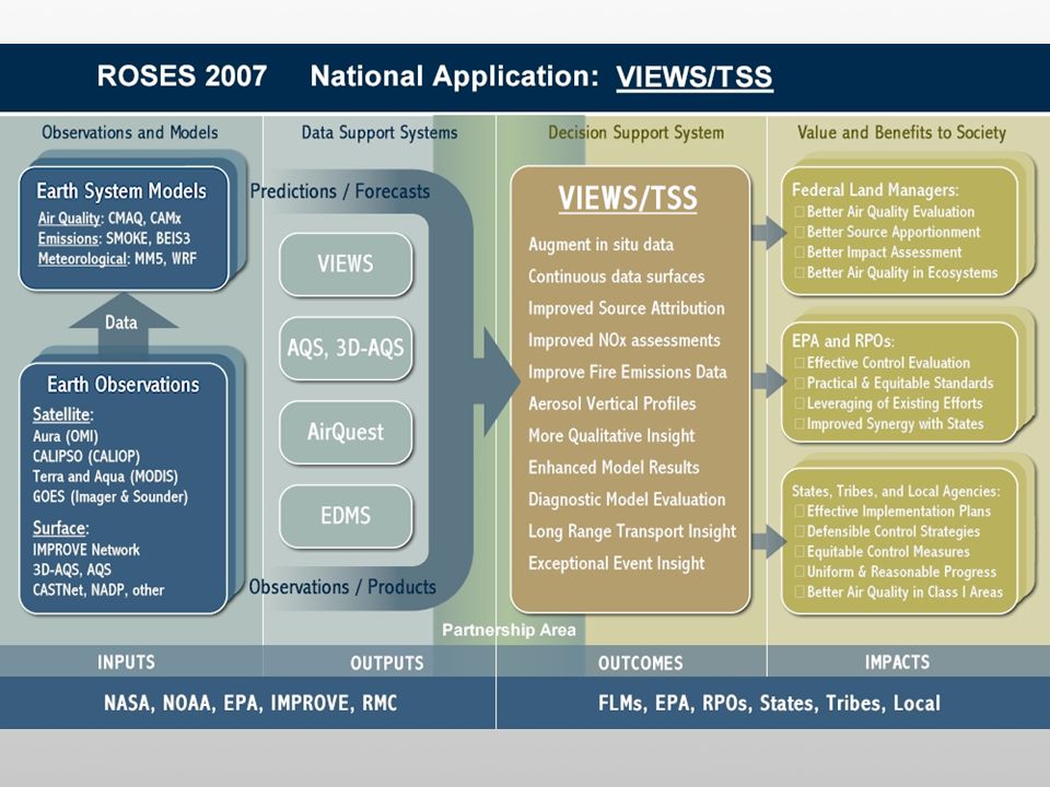
VIEWS The Visibility Information Exchange Web System http://vista.cira.colostate.edu/views Provides integrated online access to: Monitoring data: from over 3 dozen networks Modeling data: from a variety of modeling scenarios Emissions data: inventories and summaries Satellite data: MODIS, CALIPSO, Aqua, Terra, GOES, etc. Serves as the primary source for: IMPROVE Aerosol and Optical data IMPROVE Regional Haze Rule data IMPROVE Special Studies data Has about 1200 registered users from over 300 organizations, institutions, universities, and companies

3
TSS WRAP Technical Support System http://vista.cira.colostate.edu/tss Built upon the database and software infrastructure of VIEWS Provides consolidated online access to: Regional technical data, planning guidance, and analysis results Decision support for the development of SIPs and TIPs Source apportionment and visibility projections tools Ongoing tracking and assessment of emissions control strategies Documents the technical methods used in implementation plans

4
Air Quality Scenario: Societal Benefits and Beneficiaries Federal Land Managers: Better air quality evaluation More accurate source apportionment More meaningful impact assessment Informed permitting and regulation Improved air quality in ecosystems Air Quality Managers: Effective emissions control evaluation Better evaluation of exceptional events Leveraging of existing efforts Valuable case studies and precedents More effective application of resources States, Tribes, and Local Agencies: Effective Implementation Plans Defensible and achievable control strategies Uniform and reasonable progress Better air quality in Class I Areas Improved compliance with regulations Policy Makers: Better insight into international transport Reasonable and achievable policies Practical and equitable standards Air quality “best practices” examples Better synergy with the air quality community

6
Raw data access, retrieval, and exchange services Visualization and analysis services Metadata management services Participation in GEOSS Common Infrastructure (GCI) development Planned contributions to GEOSS:
 development Planned contributions to GEOSS:")
7
Dataset discovery and access: Monitoring data Modeling data Emissions inventories and summaries Satellite data Data selection, manipulation, and retrieval: Browsing Searching Filtering Aggregation Transformation Formatting Uploading Raw data access services:

8
Dynamic Spatial Interpolation and Contouring

9
Point Data Maps and Mini Charts

10
Network Inter-comparisons Parameter: Nitrate Ion Concentrations Location: Bondville, IL Networks: IMPROVE, STN, and CASTNet Graphs: Time Series and Scatter Plot

11
Model Performance Evaluation CMAQ Model Performance vs. Monitored Worst 20% Days in 2002

12
Source Apportionment Mass source apportionment by source category and region From regional photochemical model with comprehensive emissions inputs Species mass for various time periods – directly comparable to monitoring data

13
Light Extinction Glide Slopes

14
Metadata Management Tools: Monitoring Site Metadata

15
Metadata Management Tools: Exceptional Events Exceptional event metadata (such as fires, dust storms, etc) is stored and dynamically associated with data at run time in order to better inform the user about the context of the data.
 is stored and dynamically associated with data at run time in order to better inform the user about the context of the data.")
16
Metadata Management Tools: Data Advisories Data Advisories document interesting findings from the integrated database such as data anomalies, potential problems, and new uses for the data. These advisories are stored as metadata in the VIEWS database and dynamically associated with data and products. When a user selects data, the systems checks for any advisories relevant to the data selected and attaches them to the output.

17
Architecture & Interoperability Arrangement Development Work with GEOSS partners to… Design Implement Test Refine …robust and flexible Interoperability Arrangements

18
Goals for Participation in GEOSS AIP Better awareness of community interoperability efforts Better understanding and use of proposed GEOSS standards Standardization of intra- and inter-system data exchange Leveraging and reuse of existing resources through service-chaining Increased value of existing development investments Improved resource availability and decision-making for end users Standardization of Codes and Flags (possible?): SO4 = SO4f = Sulfate PM2.5 LC = Fine Sulfate ??
: SO4 = SO4f = Sulfate PM2.5 LC = Fine Sulfate")
19
TheEnd… Thanks!

Similar presentations

 Kickoff Workshop.>")


: extend current GEO IP3/AIP-2 interoperability systems in Forest, Biodiversity,>")


 Ivan 1 DeLoatch, USGS, ADC Co-chair Alessandro Annoni, EC, ADC Co-chair Jay Pearlman, IEEE, ADC.>")


 Cooperative Institute for Research in the Atmosphere.>")


: An Approach to Air Quality Data Management and Presentation In a broader sense, VIEWS facilitates.>")

 is an online.>")