Download presentation
Presentation is loading. Please wait.

1
RETRIEVING BRDF OF DESERT USING TIME SERIES OF MODIS IMAGERY Haixia Huang, Bo Zhong, Qinhuo Liu, and Lin Sun Presented by Bo Zhong bzhong1@gmail.com Institute of Remote Sensing Applications, Chinese Academy of Sciences IGRSS 2011, Vancouver, Canda

2
Outline Background Methodology Preliminary results Applicatoins Conclusions

3
Background BRDF is the key parameter for: Quantitative remote sensing Erath radiation budget More Desert is one of the main landcover types Strongly reflecting the solar radiation More

4
Problem There is no “good” BRDF product of desert

5
Methodology-flowchart MODIS imagery Converting DN to TOA reflectance Identifying the “ clearest ” of each observations Retrieving reflectance of “ clearest ” observations Fitting to Staylor-Suttles BRDF model Lookup Tables BRDF of desert

6
Methodology- site choosing Location of the experimental site (MODIS imagery color composite) Cole view of the site (TM imagery color composite)
 Cole view of the site (TM imagery color composite)")
7
Methodology- site choosing It is stable, so it can be seen as an invariant object; There are a lot of lakes within the calibration site, which are seldom polluted, so the lowest AOD of calibration site can be determined by Dark Object (DO) method using Landsat TM and ETM+ data.
 method using Landsat TM and ETM+ data.")
8
8 ( a ) Mar. 3, 2000 ( b ) Feb. 3, 2010 Methodology- site choosing
 Mar. 3, 2000 ( b ) Feb. 3, 2010 Methodology- site choosing")
9
AOD retrieval using DO method ETM+ imaging date Aerosol optical depth TM imaging date Aerosol optical depth 2000.03.030.15432006.09.200 2000.04.2902006.10.310.0440 2001.10.160.02182007.05.180.1536 2001.11.1702007.06.030 2002.01.040.06572009.06.170.4279 2002.03.180.28012009.08.110.05444 2002.05.280.32742009.08.270.0043 2002.09.170.10582009.09.280.0096 2002.11.040.36332010.02.030.07676 2002.11.130.02862010.06.040.254 2002.12.150.11952010.07.290.3552 2003.03.280.42732010.08.140 2010.08.230.2178

10
Original method Time series of MODIS imagery Identifying clear pixels Reflectance of clear pixels BRDF fitting Reflectance of hazy pixels AOD of hazy pixels LUT MODIS surface reflectance

11
Modifications for the original method AOD determination for the “clearest” days; Shrinking the use of the algorithm from globe to the desert calibration site, which is stable; Identifying the “clearest” observations for every 10 degrees in view zenith angles from 0-50 degree (0-10, 11- 20, 21-30, 31-40, and 41-50); Using Staylor-Suttles BRDF model instead of Walthall BRDF.
; Using Staylor-Suttles BRDF model instead of Walthall BRDF.")
12
MODIS-B3: Staylor-Suttles coefficients Preliminary results

13
MODIS-B1: Staylor-Suttles coefficients

14
MODIS-B2: Staylor-Suttles coefficients

15
Comparison with MODIS products

16
R 2 much higher RMSE is lower

17
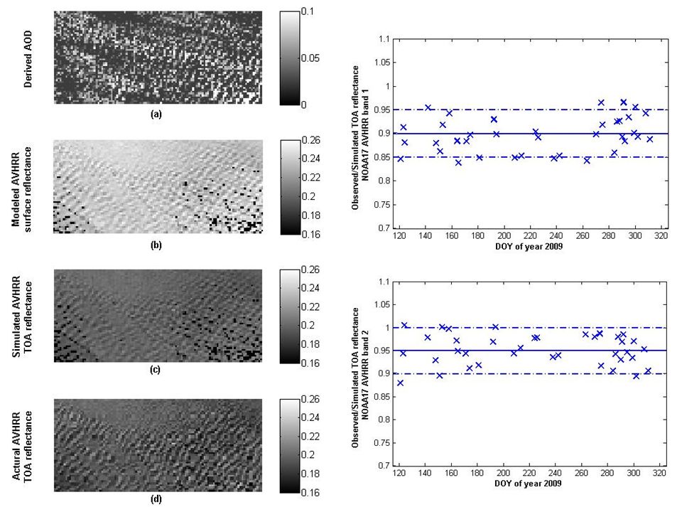
Applications I: inter-calibration of AVHRR using retrieve BRDF Spectral matching of AVHRR and MODIS AVHRR data simulation using the new method Inter-calibration Validation

18
Spectral matching AVHRR 1 (0.645 μm) AVHRR 2 (0.865 μm) AVHRR 3 (1.6 μm) aiai 0.98851.01051.0004
 AVHRR 2 (0.865 μm) AVHRR 3 (1.6 μm) aiai")
20
Applications II: global desert BRDF retrieval Mapping of the desert BRDF and AOD retrieval simultaneously using the new method Preliminary validation

21
The chosen desert sites

22
The geolocations of the deserts Desert Name Lat ( ° ) Lon ( ° ) Altitude ( m ) Duration (yyyy.mm.d) Taklimakan39.0°N-40°N84°E-85°E10502009.10.1- 210.10.1 Rabal- Khali 18.8°N-19.8°N45.5°E-46.5°E7002009.10.1- 210.10.1 Lybia24°N-25°N12°E-13°E7402009.10.1- 210.10.1 Sahara19.5°N-20.5°N8°W-9°W2602009.10.1- 210.10.1
 Lon ( ° ) Altitude ( m ) Duration (yyyy.mm.d) Taklimakan39.0°N-40°N84°E-85°E Rabal- Khali 18.8°N-19.8°N45.5°E-46.5°E Lybia24°N-25°N12°E-13°E Sahara19.5°N-20.5°N8°W-9°W")
23
Taklimakan desert

24
Rabal-Khali desert

25
Lybia desert

26
Sahara desert

27
Conclusions The new method is able to catch the BRDF characterization of deserts This method can be used for inter-calibration of reflective bands of moderate satellite data like AVHRR This method is helpful for researches on earth radiation budget

28
Thank you for your attention!

Similar presentations
University.>")

 Caroline Poulsen, Gareth Thomas, Richard Siddans, Don Grainger,>")


