Download presentation
Presentation is loading. Please wait.

1
Hurricanes …no two are the same… Bill Read Director National Hurricane Center

3
Category 1 Within 75 miles

4
Category 2 Within 75 miles

5
Category 3 Within 75 miles

6
Category 4 Within 75 miles

7
Remember the Gulf Developers 1932 – TS 180 miles south of GLS – Cat 4 at landfall less than 36h 1943, Alicia – both formed south of NOLA landfall less than 72h Audrey June 1957 – Cat 4 less then 72h after forming Anita (5), Celia (4), Camille (5) and Opal (4) all less then 96h
, Celia (4), Camille (5) and Opal (4) all less then 96h")
8
Category 2 MOM Galveston Basin Mostly barrier island and inland marsh inundation

9
While Surge is our most recent focus, let’s not forget wind Alicia Andrew

10
Potential wind threat from a Cat 4 at landfall >125 mph 110 – 125 mph 90 – 110 mph 75-90 mph 55-75 mph

11
Wind impacts Rita forecast 150 mph 1 min average winds at landfall. Gusts range 130-150 mph (1.5 x sustained)
.")
12
Peak measured Gusts in Ike

13
The nightmare urban flood Houston - June 8-9, 2001 Onset during Friday evening Onset during Friday evening About 2,000,000 folks experienced 10-15” rainfall in 6-12 hours About 2,000,000 folks experienced 10-15” rainfall in 6-12 hours About 100,000 cars, 50,000 homes flooded About 100,000 cars, 50,000 homes flooded Loss of life (21) miraculously low considering scale of flooding Loss of life (21) miraculously low considering scale of flooding
 miraculously low considering scale of flooding Loss of life (21) miraculously low considering scale of flooding")
14
(Pre Katrina) Over 800 of the 1000 deaths in 2008 were due to rainwater flooding
 Over 800 of the 1000 deaths in 2008 were due to rainwater flooding")
16
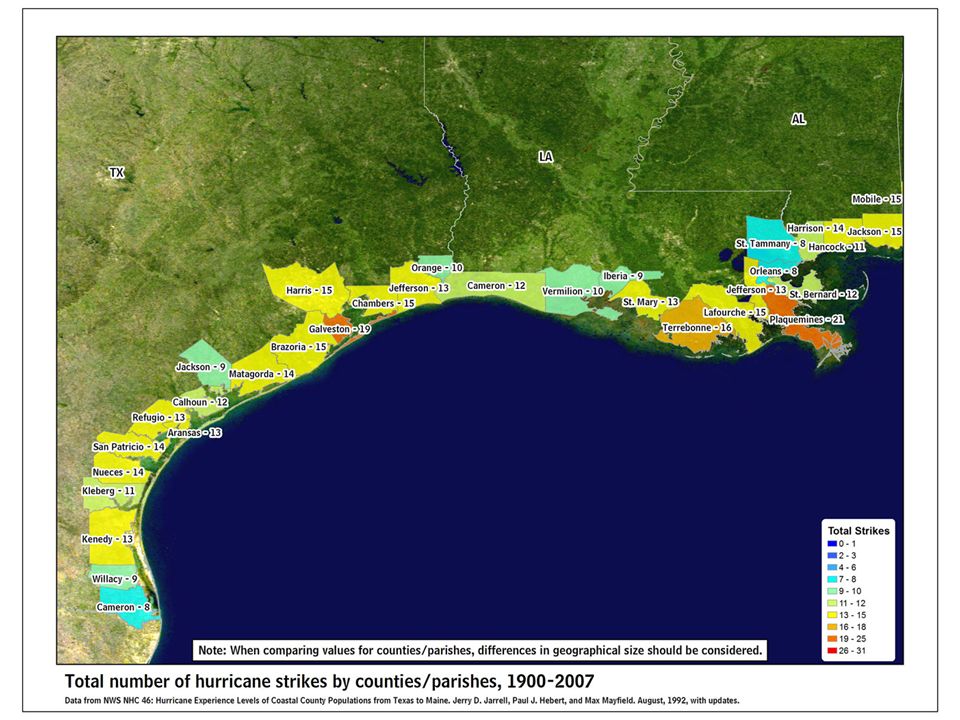
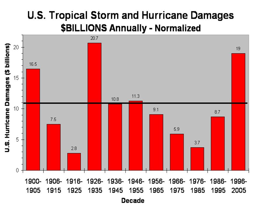
Reason for large increase

18
What’s the real hazard? We insist on living near the coast Building codes less than even modest hurricane winds (consider: Ike top 3 loss list) Land use tied to the 100 year event - Flood Insurance not “required” if outside 100 year. People begin to forget within 5 years (IEM risk management)
 Land use tied to the 100 year event - Flood Insurance not required if outside 100 year. People begin to forget within 5 years (IEM risk management).")
19
Thanks …and each one has a unique history

20
Ike Final Left 20 mi & Stronger Ike 20 miles to left - 20 mph stronger This was NHC Forecast 48H before land fall Ship Channel 25-30 feet JSC 20-22 feet Texas City 15 – 18 Feet

21
Category 1 MOM – Galveston Basin

22
Category 3 MOM – Galveston Basin Totally floods port of Galveston, significant flooding Bay area including Johnson Space Center and some petrochem facilities

23
Category 4 MOM – Galveston Basin Severe flooding Bay area, including JSC and petrochem facilities

24
Category 5 MOM – Galveston Basin All but small section of Galveston County (pop 280,000) flooded. Houston Ship Channel and port severely damaged.

Similar presentations


 Wind: 74-95 miles per hour (mph) Storm Surge: 4-5.>")


