Download presentation
Presentation is loading. Please wait.

2
Remote Sensing & Geo-Information Systems Transdisciplinary Assessment & Implementation Framework Decision Making Process & Implementation Area Identification Ecosystem Functioning & Biophysical Processes Stakeholders, Livelihoods & Networks Scoping Policy & Institutional Arrangements Ecosystem Goods, Services & Valuation Ecological ValuationSocio-Cultural ValuationEconomic Valuation Analysis of Opportunities and Constraints Multi-Functional Use Financing, Payments & Reward Mechanisms Environmental Impact Assessment Policy & Institutional Measures Adaptive Management & Organisational Learning Communication & Dissemination Implementation Strategy Development Stakeholder & Social Preferences Synergies & Trade-offs Scenario Development & Options (SWOT) Stakeholder and Expert Consultation Stakeholder and Expert Participation Monitoring, Management E ffectiveness & Evaluation Source: EarthCollective (eds) (2007b) Testing the SELS framework with respect to: restoration of ecosystem/landscape services (understanding the trade-offs with land-use changes) transdisciplinarity & integration of concepts effective stakeholder engagement (how does the framework answer the right questions for the right people?) bridging research-implementation gap Contribution to scientific understanding of values, perceptions, trade-offs, management & financing across institutional & geographical scales.
 Stakeholder and Expert Consultation Stakeholder and Expert Participation Monitoring, Management E ffectiveness & Evaluation Source: EarthCollective (eds) (2007b) Testing the SELS framework with respect to: restoration of ecosystem/landscape services (understanding the trade-offs with land-use changes) transdisciplinarity & integration of concepts effective stakeholder engagement (how does the framework answer the right questions for the right people ) bridging research-implementation gap Contribution to scientific understanding of values, perceptions, trade-offs, management & financing across institutional & geographical scales.")
3
‘Water’ Hydrological & Watershed Services ‘Fire’ Managing for biodiversity outcomes ‘Wind’ C0 2 & GHGs Carbon Sequestration ‘Earth’ Biodiversity Soil Quality & Erosion Ctrl Payments for Water Services Upstream/Downstream willingness to pay/accept; Sale of water rights; ‘Working for Water’ & ‘Working for Wetlands’ Carbon Market Voluntary and CDM; ‘Working for Woodlands’ Landschapsveiling: Fund fire management ‘Working on Fire’ Landschapsveiling: Bundling various ES & biodiversity outcomes ‘Restourism’ Tourism & restoration

4
K. Janssen ‘Wind’ Carbon sequestration

5
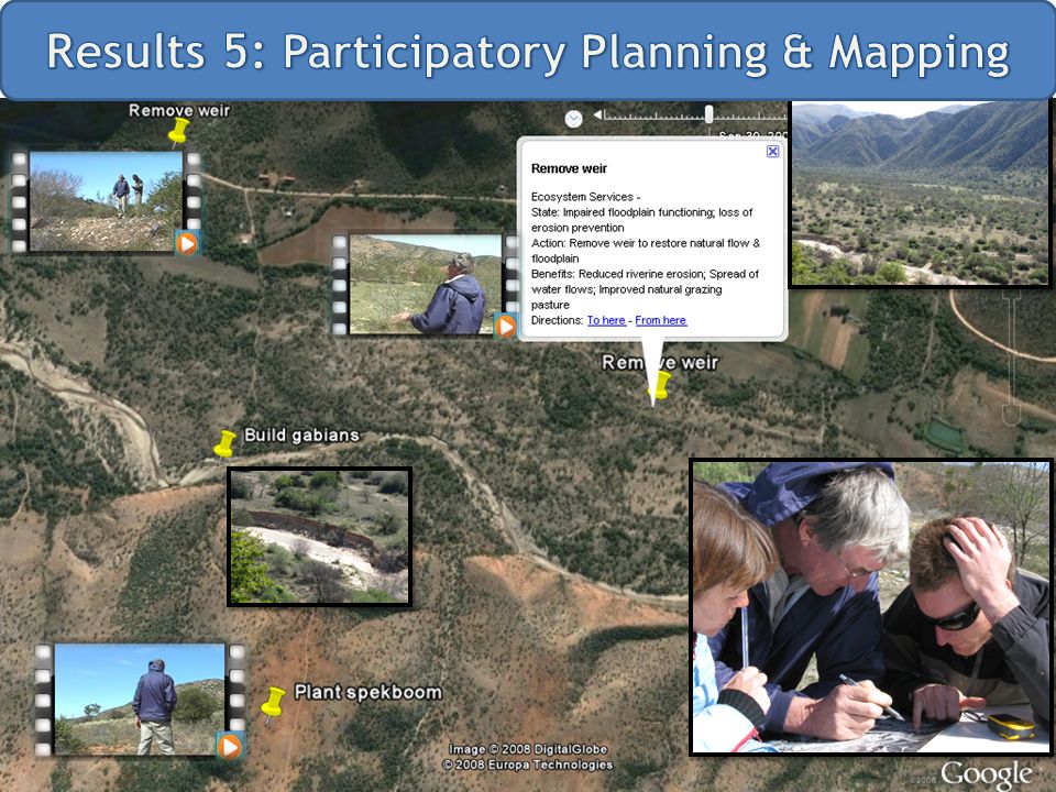
Restoring of Wetlands and Floodplains (how) Picture of work on piet farm (restoring flood plains), picture of the work in the Kromme (gabions) picture’s of resembles ecosystems good & service what will improved natural grazing livestock farming tourism Soil retention (dam) Biodiversity basis flow water availability picture of people working in nursery & planting (employment not ecosystem services but important) In partnership with LNV – WUR (Alterra & LEI) (Pending Partnership with Working for Wetlands) ‘Water’ Hydrological & Watershed Services
 Picture of work on piet farm (restoring flood plains), picture of the work in the Kromme (gabions) picture’s of resembles ecosystems good & service what will improved natural grazing livestock farming tourism Soil retention (dam) Biodiversity basis flow water availability picture of people working in nursery & planting (employment not ecosystem services but important) In partnership with LNV – WUR (Alterra & LEI) (Pending Partnership with Working for Wetlands) ‘Water’ Hydrological & Watershed Services")
7
2 Scientific Publications in progress Zylstra, M. (in press) ‘Lessons Learned from applying the Ecosystem Approach: The Baviaanskloof’. Chapter in IUCN Commission on Ecosystem Management (CEM) Publication Zylstra & Van den Broeck (in press) ‘Elemental Equity: An intuitive interface for mainstreaming payments for ecosystem services (PES)?’ 7 Scientific Presentations / Papers / Posters Results presented/disseminated at: Interfaces (Arid Zones & Fynbos) Forum: Aug. 08 South African Thicket Forum: Aug. 08 South African Wildlife Management Association (SAWMA): Sept. 08 IUCN World Conservation Congress: Oct.08 WUR-ESA Lunch Presentation: Oct. 08 Baviaanskloof Research-Implementation Coordination Workshop: Oct.08
 ‘Lessons Learned from applying the Ecosystem Approach: The Baviaanskloof’. Chapter in IUCN Commission on Ecosystem Management (CEM) Publication Zylstra & Van den Broeck (in press) ‘Elemental Equity: An intuitive interface for mainstreaming payments for ecosystem services (PES) ’ 7 Scientific Presentations / Papers / Posters Results presented/disseminated at: Interfaces (Arid Zones & Fynbos) Forum: Aug. 08 South African Thicket Forum: Aug. 08 South African Wildlife Management Association (SAWMA): Sept. 08 IUCN World Conservation Congress: Oct.08 WUR-ESA Lunch Presentation: Oct. 08 Baviaanskloof Research-Implementation Coordination Workshop: Oct.08.")
8
+/- 10 WUR MSc thesis reports 2 Scientific Publications 1-2 PhD position proposals 1 PRESENCE Workshop (multi-stakeholder) 1 Landscape Auction (Landschapsveiling) 2 Participatory planning workshops (scientists, implementers and stakeholders) 1 Ecosystem Management Workshop (with IUCN-CEM) 1-2 Presentations at the Conference on Economics in Natural Resource Management (Cape Town, SA) and Water Management Conference (Port Elizabeth) Reporting to SELS & WUR Chair Groups
 1 Landscape Auction (Landschapsveiling) 2 Participatory planning workshops (scientists, implementers and stakeholders) 1 Ecosystem Management Workshop (with IUCN-CEM) 1-2 Presentations at the Conference on Economics in Natural Resource Management (Cape Town, SA) and Water Management Conference (Port Elizabeth) Reporting to SELS & WUR Chair Groups")
9
- Haider Ali Javed - Lennart van der Burg - Ignacio de la Flor - Kim Janssen - Eliska Lorencova - Emmanuelle Noirtin - Janneke Spekreijse - Gamtoos Irrigation Board - R3G & its members / advisors - Eastern Cape Parks - CSIR - PRESENCE platform partners WUR (ESA, ENP, ENR, GRS, SOQ, LEI, Alterra, WUR (ESA, ENP, ENR, GRS, SOQ, LEI, Alterra, SELS) CSIR, RU, ASSET Research... - All willing & patient ‘stakeholders’...

Similar presentations


. BEST METHODS (POLICY, TOOLS AND TECHNIQUES) TO ENHANCE.>")


 => first European document dedicated exclusively.>")


