Download presentation
Presentation is loading. Please wait.

1
__________________________ SITES 2005.1.4 INTEGRATED DEVELOPMENT ENVIRONMENT for WATER RESOURCE SITE ANALYSIS COMPLEX WATERSHEDS SITES IN SERIES

2
OBJECTIVES Understand concepts related to dam design with complex watersheds Discuss stream reach routing options

3
UPPER LOWER

4
UPPER LOWER

5
Dams in Series Policy - Dams in series are to be given special consideration (NEM-210 520.24) NEM-210 520.27(b)(2)(i) breach considerations.
 NEM (b)(2)(i) breach considerations.")
6
Upper Dam Hydrologic criteria and procedures (TR-60) – same as or more conservative than those for downstream dams - if failure of the upper dam could contribute to the failure of the lower dam –If routing through an upper dam and it is overtopped it is to be considered breached. –Dam breach criteria TR -60 p 1-1

7
Complex Watersheds Hydrologically homogeneous W/S Soil and Cover Size

8
Complex Watersheds Drainage areas above 25 square miles should be subdivided. Goal - Hydrologically Homogeneous Areas Drainage areas more than 10 square miles should be considered for subdivision.

9
Upstream Site Homogeneous or Subdivided -- assumed to be in place for the design of the lower site. Site is routed only Spillway materials data not required. Minimum data can be included in structure table.

10
Downstream Site Site to be designed. If Integrity analysis is required - then all data is required.

11
Sites in Series Upper Dam Reach Lower Dam The upper dam is considered a feature of the watershed for the design of the lower dam.

12
Lower Dam Hydrographs from upper controlled areas are based on same criteria as for lower dam. Flows are routed through spillways of all upper dams and channel reaches to the lower dam where they are combined with the hydrographs from any uncontrolled drainage area. The combined hydrographs are used to flood route the lower dam.

13
W/S DATA The hydrologic characteristics of the uncontrolled area or subarea are to be used to develop all of the required input data for the area or subarea. This data includes - DA, Tc, CN, stage- storage, sediment, hazard class, rainfall, Ci, Baseflow, etc.

14
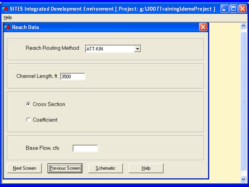
Stream Reach Routing Options

15
Reach Length The length of channel through which a hydrograph will be routed. In most cases the distance downstream from the outlet of the upstream site to the most upstream normal pool elevation of the dam downstream.

16
Reach 1 Reach 2 Upper Dam Lower Dam This is an example of a reach routing where the characteristics of the channel were not the same for the whole reach. So two reaches have been used to represent the channel.

17
Cross Section Rating Curve The shape of the cross section with possible multiple roughness values gives stage, area, and discharge that is used to define how the hydrograph will be routed downstream.

18
Example of a subdivided cross section - note areas of multiple roughness shown in the sections. 7 8

19
Muskingum-Cunge Reach Routing In SITES

20
Reach Cross Section Rating Table Data derived from HECRAS, Manning’s, etc. Reach Length = 5400 feet, Bankfull Elevation = 2422.5

22
Rating Table

23
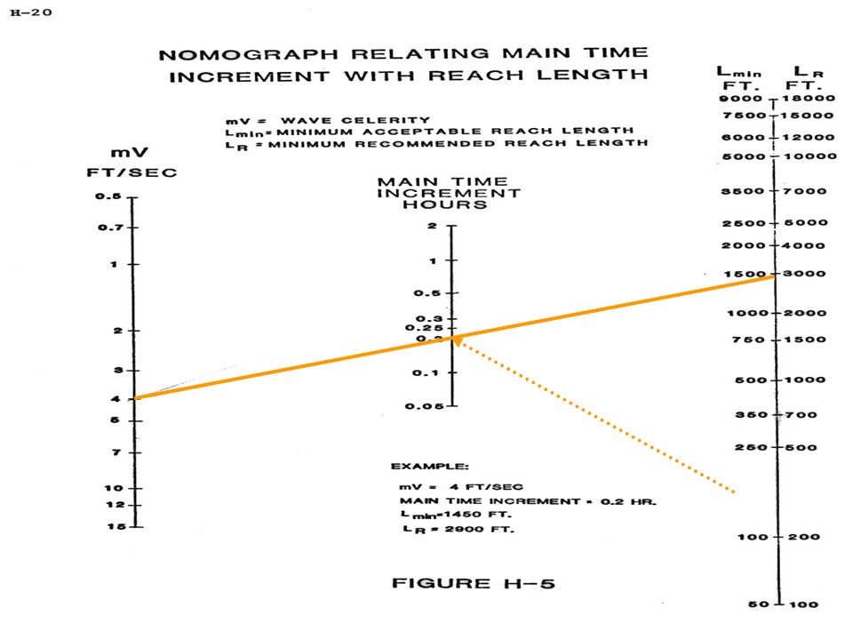
Fig 17-13 Convex routing coefficient versus velocity

25
Taken from App. H in TR-20

Similar presentations

>")


 Rainfall-runoff modeling ERS 482/682 Small Watershed Hydrology.>")


