Download presentation
Presentation is loading. Please wait.

1
Structure of Ocean Basins Chapter 4

3
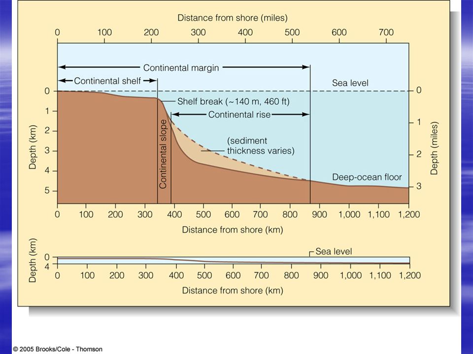
Continental shelves Part of continents Exposed or not exposed depending on sea level Cut by submarine canyons Vary in width depending on type of margin Accumulate sediment from the continents (including rivers) Fun fact: 25 % of global continental shelf is in the Bering Sea (very productive fisheries)
 Fun fact: 25 % of global continental shelf is in the Bering Sea (very productive fisheries)")
4
Continental Slope Separated from the shelf at the shelf break (~ 130 m). Continues to an average depth of about 4000 m (range is 3000-8000 m) Most prominent topographic feature on earth Marks the end of continents and the beginning of ocean crust Average width of 20 – 100 km Average slope of 4 o (road grade) - 70 m/km or 370 feet/mile
 Most prominent topographic feature on earth Marks the end of continents and the beginning of ocean crust Average width of 20 – 100 km Average slope of 4 o (road grade) - 70 m/km or 370 feet/mile.")
5
Continental Rise Sediments from the shelf move down the continental slope and accumulate on the continental rise. Most are transported there by turbidity currents or through riverine-derived canyons. Width of the rise varies and slope is gradual. Deep sea currents shape the rises. Slope is about 1/8 that of the Continental slope (about 0.5 o or < 10 m/km or < 50 feet/mile) Rise absent when slope terminates in a trench Conspicuous features of passive (tectonically inactive) margins so rare in the Pacific
 Rise absent when slope terminates in a trench Conspicuous features of passive (tectonically inactive) margins so rare in the Pacific.")
7
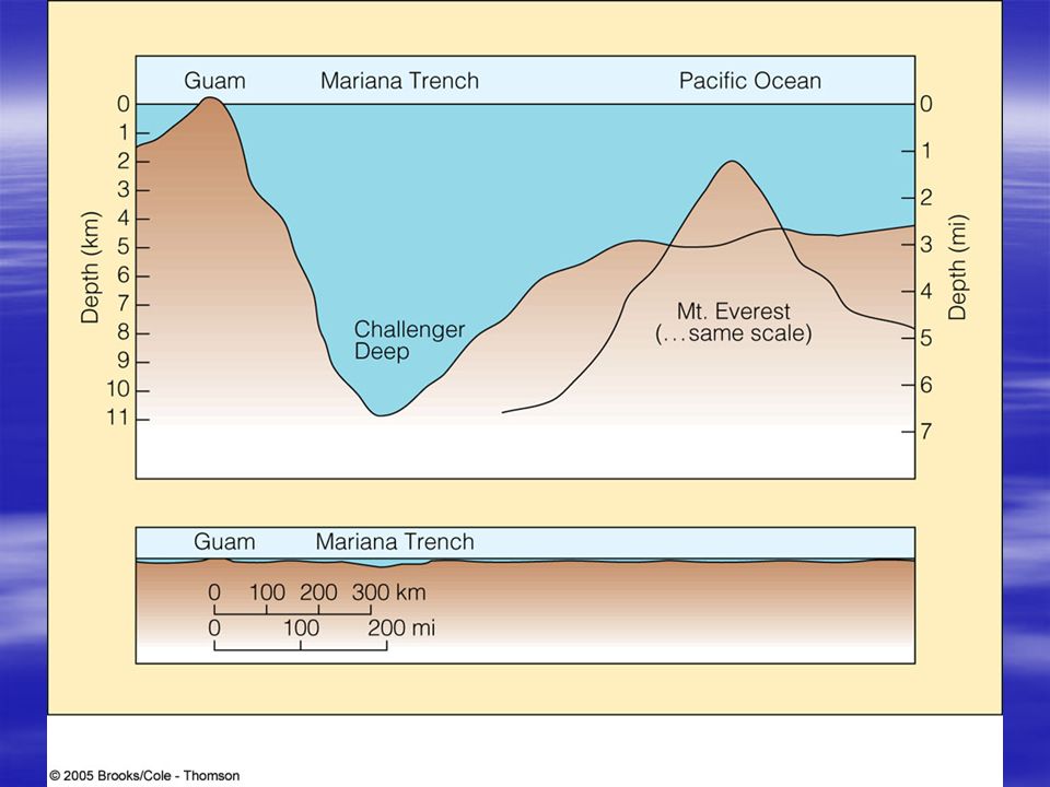
Trenches Act as sediment traps! Peru-Chile trench – oldest at the S end (shallower because its full of sediments) and vice versa Feature of active margin/subduction zone
 and vice versa Feature of active margin/subduction zone.")
8
Deep Ocean Basins Mainly, abyssal plains and ocean ridges Also, trenches, seamounts and guyots Include more than half the earth’s surface

9
Abyssal plain True sea floor Flat, sediment-covered ocean floor Sediments often more than 1000 m thick (not so featureless underneath sediments) Begins at the base of the continental rise Very flat except for abyssal hills (which are low, < 1 km high, origin unclear), seamounts and guyots and islands 25% of the earth’s surface and 42% of the ocean bottom is plain Most common in the Atlantic and rare in the Pacific where trenches trap sediments Average of about 4000 – 5500 m depth
 Begins at the base of the continental rise Very flat except for abyssal hills (which are low, < 1 km high, origin unclear), seamounts and guyots and islands 25% of the earth’s surface and 42% of the ocean bottom is plain Most common in the Atlantic and rare in the Pacific where trenches trap sediments Average of about 4000 – 5500 m depth")
10
Abyssal hills Not very high and steep Protruding ocean floor topography?

11
Abyssal plain sediments bury old mountains (image generated by Echo sounding)
")
12
Important features of the sea floor Trenches –Extremely deep –Found in association with plate margins (converging); mainly in the Pacific because of plates there Seamounts and guyots –Guyots are flat-topped seamounts (eroded) –Islands are seamounts that break the sea surface Coral reefs –Most common in Pacific with range 40 o N and 40 o S –Require warm water, light (deepest living corals at 100 m), salinity (no freshwater forms) and low sediment load. –Fragile ecosystems

13
Trenches Convergence zones Cold at the bottom 3 to 6 km deeper than adjacent seafloor Trenches curved because of geometry of plate interactions on a sphere Trench steeper on the island/continent side than the seaward side Tectonically active Big sediment traps

15
Island arcs Parallel to trenches Chain of islands behind a trench

17
Seamounts and guyots Circular or eliptical More than 1 km in relief Alone or in groups Old hot spots or extinct volcanoes formed at spreading centers Guyots have flat tops

19
Coral reef formation Atolls – around volcanoes Fringe reefs Corals grow up to keep in the sunlight Evidence of old reefs at 1400 m

20
Oceanic Ridges Includes diverging and converging boundaries. 15 cm/yr at Iceland

21
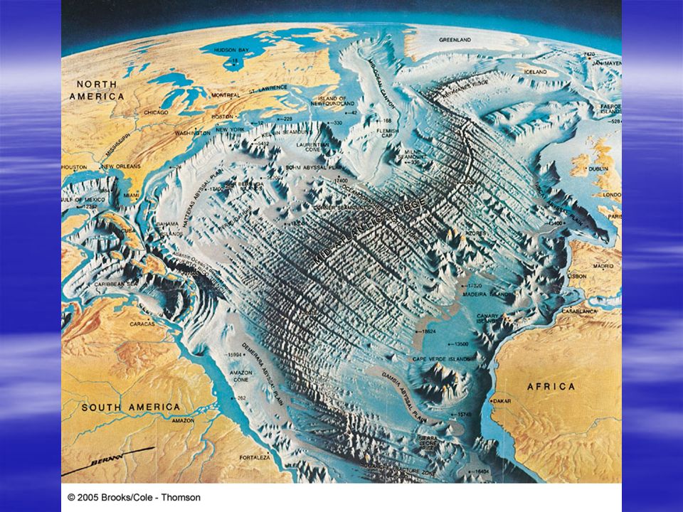
Ocean ridge system Describe plate boundaries Largest and longest mountain range on earth Made up of young, basaltic rock at active spreading centers Ridges devoid of sediment Oceanic ridges and associated structures account for 22% of the world’s surface (compare to all land which is 29%!) < 60% of their length is at the center of basins Youngest rocks at spreading centers Steeper ridges at slower spreading centers
 < 60% of their length is at the center of basins Youngest rocks at spreading centers Steeper ridges at slower spreading centers")
22
Lavas Lava cooling underwater forms pillow lavas –Solidifies rapidly because of contact with cold seawater; this also slows flow –Water pressure keeps gases in magma “solution” during cooling Lave extruded on land –Cools more slowly; flows longer –Releases gases (sometimes explosively)
")
24
Transform faults Fractures in the lithosphere along which movement has occurred Characterized by shallow earthquakes A result of the earth being a sphere Transform faults are the active parts of fracture zones Fracture zones extend further away from ridge axis and are evidence of past transform faulting. Lithospheric plate on either side of transform faults move in opposite directions Outward sections of fracture zones move in the same direction

26
Structure of the mid-Atlantic Ridge between FL and W. Africa Depressed central rift valley is in blue

27
Further North and West Seismic profile of ridge being buried

28
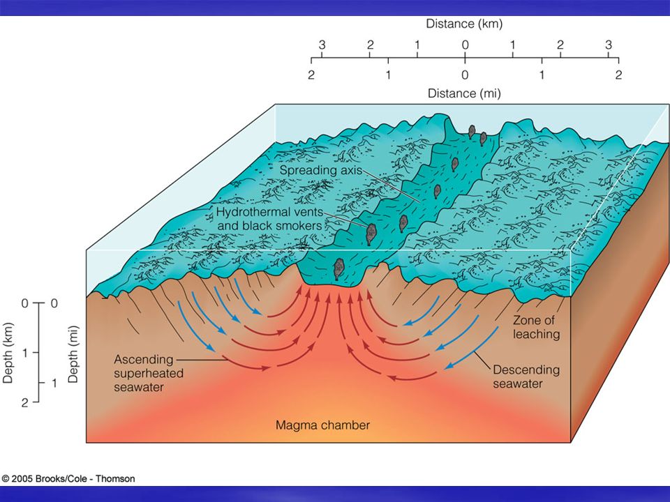
Hydrothermal vents Discovered only in 1977 along the East Pacific Rise (now found on mid-Atlantic Ridge, in the Sea of Cortez and on the Juan de Fuca Ridge) Really hot (~ 350 o C), mineral-rich water (black smokers). Can form chimneys, deposit minerals, affects ocean chemistry, etc. Seawater descends through fissures to meet hot rock. Superheated seawater dissolves minerals and escapes upward. Found in Lake Baikal – future ocean? Average water temperature is 8 – 16 o C (bottom ocean water is 4 o C)
.")
31
Broad continental shelves Trenches Ridges GBR Red Sea Galapagos Iceland

32
Take home points Continental shelf, break, slope and rise (relative slopes) Abyssal plains Mid-ocean ridge system (describes plate boundaries) Hydrothermal vents, coral reefs, seamounts and guyots
 Abyssal plains Mid-ocean ridge system (describes plate boundaries) Hydrothermal vents, coral reefs, seamounts and guyots")
33
Opening since the Miocene (65 million years ago)
")
Similar presentations