Download presentation
Presentation is loading. Please wait.

1
www.seegrid.csiro.au Data standards and client software How the demonstrator application uses the data standards

2
SEEGrid Roadshow 2005 Outline Client types Goals Loading a map and application “Chaining” queries Presenting results “Binding” to a service Presentation options – SVG vs static graphics

3
SEEGrid Roadshow 2005 Clients and Data Repositories Business Applications Web Services GIS Update Internal systems External Data Providers Web Services Metadatabase Desktop GeoDB Metadatabase Enterprise GeoDB

4
SEEGrid Roadshow 2005 Search – WFS/GML in a web site Websford Park Resources: BBQ, Tennis Courts, Sports Fields. Actions: Make a booking, make a request, view map Local-e Case Study

5
SEEGrid Roadshow 2005 WFS – integrated map & report Local-e Case Study

6
SEEGrid Roadshow 2005 Goals Implement “desired” functionality to exploit data services Configure functionality using “abstract model” Allow runtime “binding” based on standards- based portable configurations What does this mean? We shall see..

7
SEEGrid Roadshow 2005 Loading an application Application brings together: Context (what content is shown) Layout (how content is shown) Workflow (what functions available)
 Layout (how content is shown) Workflow (what functions available)")
8
SEEGrid Roadshow 2005 WebMap Composer Application Architecture Application Framework Browser Stylesheets Bindings Context Layout SDE ArcIMS WMS Custom Service XML Encoded query WMS Proxy Internet GetCapabilities GetMap FeatureInfo GML response GML response Invoke {layout + context + area + application specific parameters (e.g. indicator)} Oracle Geoserver Query constraints Schema mapping NVIS Veg Description WFS query Query Map
} Oracle Geoserver Query constraints Schema mapping NVIS Veg Description WFS query Query Map.")
9
SEEGrid Roadshow 2005 Context XML document Will eventually be an interoperable standard Map layers WMS WFS Query Styling (map and query rendering) Selection action Related info Locator, gazetteers, descriptive text
 Selection action Related info Locator, gazetteers, descriptive text")
10
SEEGrid Roadshow 2005

11
Layout What “widgets” are available How they behave: Initial visibility and state Triggering and receiving status changes from each other Grouping into separately loadable “panels” for scalability Default configurations

12
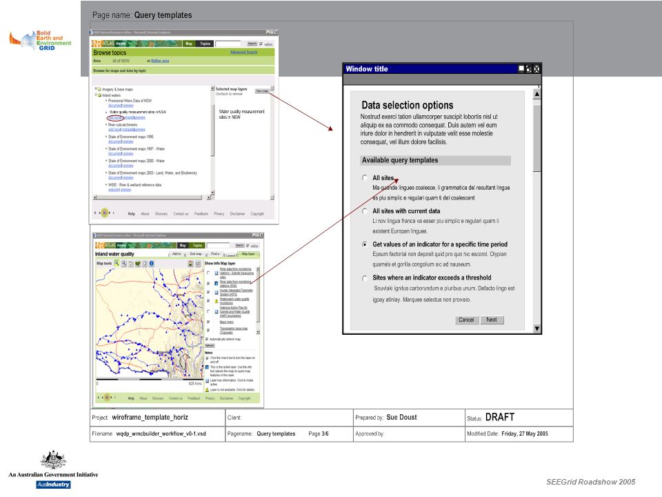
SEEGrid Roadshow 2005 Chaining Queries Simple – “feature identity” and target URL template (hand-off) More complex – run a specific query for a given data type As implemented Can pass info from current map and current layer
 More complex – run a specific query for a given data type As implemented Can pass info from current map and current layer")
13
SEEGrid Roadshow 2005 Report for Map/Selection

14
SEEGrid Roadshow 2005 Report for sample

15
SEEGrid Roadshow 2005 Data download options

16
SEEGrid Roadshow 2005 = automatic or user-friendly only if data standards available

17
SEEGrid Roadshow 2005

19
Building a query Form creation not a trivial task: Custom form Vocabulary-aware forms engine XSL NB – we have rejected typical GIS/DB approaches: cannot handle complex composite objects cannot use external vocabularies rely on instant access to data for usabilty

20
SEEGrid Roadshow 2005 Presentation Options Webmap Composer Display properties Current symbol(s) Layer name Edit symbolsFind other symbols Next Cancel Pass Fail Unknown ? ? Webmap Composer Display properties Symbol options Current symbol(s) SaveCancel Default ANZECC Streamwatch Nostrud exerci Suscipit None Pass Fail Unknown ? ? Webmap Composer Display properties Save Cancel ? ? edit|delete Quality Pass Fail Unknown >36 < Unknown Symbolisation rules NameAttributeValueSymbol edit|delete edit|delete Add new symbol Webmap Composer Display properties Reporting display properties NextCancel Show item/site details Generate graph(s) Generate text report Generate download Let map user choose(only shown in Layer setup mode) Info tool options What should happen when a user clicks on a map feature? Duis autem vel eum iriure dolor in hendrerit in vulputate velit esse molestie consequat,vel illum dolore eu feugiat nulla facilisis.
 SaveCancel Default ANZECC Streamwatch Nostrud exerci Suscipit None Pass Fail Unknown . Webmap Composer Display properties Save Cancel . edit|delete Quality Pass Fail Unknown >36 < Unknown Symbolisation rules NameAttributeValueSymbol edit|delete edit|delete Add new symbol Webmap Composer Display properties Reporting display properties NextCancel Show item/site details Generate graph(s) Generate text report Generate download Let map user choose(only shown in Layer setup mode) Info tool options What should happen when a user clicks on a map feature. Duis autem vel eum iriure dolor in hendrerit in vulputate velit esse molestie consequat,vel illum dolore eu feugiat nulla facilisis..")
21
SEEGrid Roadshow 2005 Setup query/presentation for a related FeatureType

22
SEEGrid Roadshow 2005

23
Meta (data) model
 model")
24
SEEGrid Roadshow 2005 Actual system….

25
SEEGrid Roadshow 2005 SVG (client-side) More visual interaction (highlighting objects on roll-over) Powerful styling options (Potentially) browser-portable Selection of object gives direct access to feature geometry in client Engineering challenges – (OS SVG styles > 300Kb) Modularisation issues
 More visual interaction (highlighting objects on roll-over) Powerful styling options (Potentially) browser-portable Selection of object gives direct access to feature geometry in client Engineering challenges – (OS SVG styles > 300Kb) Modularisation issues")
Similar presentations


>")


