Download presentation
Presentation is loading. Please wait.

1
Version 1.0, 20 April 2005 Slide: 1 APPLICATIONS OF METEOSAT SECOND GENERATION (MSG) RGB IMAGES: PART 04 RGB COMPOSITES WITH CHANNELS 01-11 AND THEIR INTERPRETATION Author:Jochen Kerkmann (EUMETSAT) jochen.kerkmann@eumetsat.int Contributors:D. Rosenfeld (HUJ), G. Bridge (EUM)
, G. Bridge (EUM).")
2
Version 1.0, 20 April 2005 Slide: 2 PART 4: RED-GREEN-BLUE COLOUR COMPOSITES WITH CHANNELS 01 - 11 AND THEIR INTERPRETATION

3
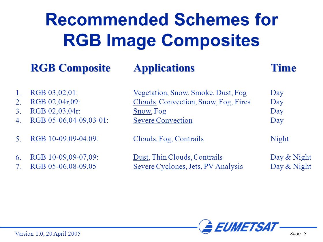
Version 1.0, 20 April 2005 Slide: 3 Recommended Schemes for RGB Image Composites RGB CompositeApplicationsTime RGB 03,02,01:Vegetation, Snow, Smoke, Dust, FogDay RGB 02,04r,09:Clouds, Convection, Snow, Fog, FiresDay RGB 02,03,04r:Snow, FogDay RGB 05-06,04-09,03-01:Severe ConvectionDay RGB 10-09,09-04,09:Clouds, Fog, ContrailsNight RGB 10-09,09-07,09:Dust, Thin Clouds, ContrailsDay & Night RGB 05-06,08-09,05Severe Cyclones, Jets, PV AnalysisDay & Night 1. 2. 3. 4. 5. 6. 7.
4
Version 1.0, 20 April 2005 Slide: 4 R = Channel 03 (NIR1.6) G = Channel 02 (VIS0.8) B = Channel 01 (VIS0.6) 1. RGB 03, 02, 01 ("Day Natural Colours") Applications: Applications:Vegetation, Dust, Smoke, Fog, Snow Area: Area:Full MSG Viewing Area Time: Time:Day-Time
 Applications: Applications:Vegetation, Dust, Smoke, Fog, Snow Area: Area:Full MSG Viewing Area Time: Time:Day-Time.")
5
Version 1.0, 20 April 2005 Slide: 5 Recommended Range and Enhancement: BeamChannelRangeGammaGamma2 Red03 (NIR1.6)0 …+100 %1.01.0 Green02 (VIS0.8)0... +100 %1.01.0 Blue01 (VIS0.6)0... +100 %1.01.0 1. RGB 03, 02, 01 ("Day Natural Colours")
 % RGB 03, 02, 01 ( Day Natural Colours ).")
6
Version 1.0, 20 April 2005 Slide: 6 Ch.03 NIR1.6 Ch.02 VIS0.8 Ch.01 VIS0.6

7
Version 1.0, 20 April 2005 Slide: 7 RGB 03, 02, 01 Example: Snow NIR1.6 VIS0.8 VIS0.6 In RGB 03,02,01 images, snow appears in cyan colour ! The values shown above (in the red box) correspond to the location (shown by an arrow) on the next slide !
 correspond to the location (shown by an arrow) on the next slide !.")
8
Version 1.0, 20 April 2005 Slide: 8 MSG-1, 18 February 2003, 13:00 UTC RGB 03, 02, 01 Example: Snow

9
Version 1.0, 20 April 2005 Slide: 9 RGB 03, 02, 01 Example: Vegetation NIR1.6 VIS0.8 VIS0.6 In RGB 03,02,01 images, vegetation appears in greenish colours ! The values shown above (in the red box) correspond to the location (shown by an arrow) on the next slide !
 correspond to the location (shown by an arrow) on the next slide !.")
10
Version 1.0, 20 April 2005 Slide: 10 MSG-1, 23 June 2003, 15:00 UTC RGB 03, 02, 01 Example: Vegetation

11
Version 1.0, 20 April 2005 Slide: 11 NIR1.6 VIS0.8 VIS0.6 RGB 03, 02, 01 Example: Desert In RGB 03,02,01 images, deserts appear in reddish colours ! The values shown above (in the red box) correspond to the location (shown by an arrow) on the next slide !
 correspond to the location (shown by an arrow) on the next slide !.")
12
Version 1.0, 20 April 2005 Slide: 12 MSG-1, 3 February 2004, 11:30 UTC RGB 03, 02, 01 Example: Desert

13
Version 1.0, 20 April 2005 Slide: 13 RGB 03, 02, 01 Example: Low-level Water Clouds (St, Sc) NIR1.6 VIS0.8 VIS0.6 In RGB 03,02,01 images, low water clouds with small droplets appear in whitish-pinkish colours ! The values shown above (in the red box) correspond to the location (shown by an arrow) on the next slide !
 correspond to the location (shown by an arrow) on the next slide !.")
14
Version 1.0, 20 April 2005 Slide: 14 MSG-1, 03 February 2004, 11:30 UTC RGB 03, 02, 01 Example: Low-level Water Clouds (St, Sc)
")
15
Version 1.0, 20 April 2005 Slide: 15 MSG-1 19 April 2005 12:00 UTC RGB 03, 02, 01 Global View

16
Version 1.0, 20 April 2005 Slide: 16 RGB 03, 02, 01: Interpretation of Colours Ocean Veg. Land Desert Snow High-level ice clouds Low-level water clouds

17
Version 1.0, 20 April 2005 Slide: 17 R = Channel 02 (VIS0.8) G = Channel 04r (IR3.9, solar component) B = Channel 09 (IR10.8) 2. RGB 02, 04r, 09 ("Day Microphysical") Applications: Applications:Cloud Analysis, Convection, Fog, Snow, Fires Area: Area:Full MSG Viewing Area Time: Time:Day-Time
 Applications: Applications:Cloud Analysis, Convection, Fog, Snow, Fires Area: Area:Full MSG Viewing Area Time: Time:Day-Time.")
18
Version 1.0, 20 April 2005 Slide: 18 2. RGB 02, 04r, 09 ("Day Microphysical") Recommended Range and Enhancement (Summer): BeamChannelRangeGammaGamma2 Red02 (VIS0.8)0 …+100 %1.01.0 Green04r (IR3.9r)0... +60 %2.51.0 Blue09 (IR10.8)+203... +323 K1.01.0
 Recommended Range and Enhancement (Summer): BeamChannelRangeGammaGamma2 Red02 (VIS0.8)0 …+100 % Green04r (IR3.9r) % Blue09 (IR10.8) K")
19
Version 1.0, 20 April 2005 Slide: 19 2. RGB 02, 04r, 09 ("Day Microphysical") Recommended Range and Enhancement (Winter): BeamChannelRangeGammaGamma2 Red02 (VIS0.8)0 …+100 %1.01.0 Green04r (IR3.9r)0... +25 %1.51.0 Blue09 (IR10.8)+203... +323 K1.01.0
 Recommended Range and Enhancement (Winter): BeamChannelRangeGammaGamma2 Red02 (VIS0.8)0 …+100 % Green04r (IR3.9r) % Blue09 (IR10.8) K")
20
Version 1.0, 20 April 2005 Slide: 20 Ch.02 VIS0.8 Ch.04r IR3.9r Ch.09 IR10.8 MSG-1, 8 September 2003, 12:00 UTC RGB Composite 02, 04r, 09 "winter" enhancement (see previous slide)
")
21
Version 1.0, 20 April 2005 Slide: 21 RGB 02, 04r, 09 Example: Severe Convection VIS0.8 IR3.9r IR10.8 In RGB 02,04r,09 images, cold Cb clouds with small ice particles appear in light orange colours ! The values shown above (in the red box) correspond to the location (shown by an arrow) on the next slide !
 correspond to the location (shown by an arrow) on the next slide !.")
22
Version 1.0, 20 April 2005 Slide: 22 RGB 02, 04r, 09 Example: Severe Convection MSG-1, 20 May 2003, 13:30 UTC ("winter" enhancement)
")
23
Version 1.0, 20 April 2005 Slide: 23 RGB 02, 04r, 09 Example: Ship Trails VIS0.8 IR3.9r IR10.8 In RGB 02,04r,09 images, ship trails (small droplets) appear in whitish - light bluish colours ! The values shown above (in the red box) correspond to the location (shown by an arrow) on the next slide !
 correspond to the location (shown by an arrow) on the next slide !.")
24
Version 1.0, 20 April 2005 Slide: 24 RGB 02, 04r, 09 Example: Ship Trails MSG-1, 7 September 2003, 11:45 UTC ("winter" enhancement)
")
25
Version 1.0, 20 April 2005 Slide: 25 RGB 02, 04r, 09 Example: Fires VIS0.8 IR3.9r IR10.8 In RGB 02,04r,09 images, forest fires appear in cyan colour ! The values shown above (in the red box) correspond to the location (shown by an arrow) on the next slide !
 correspond to the location (shown by an arrow) on the next slide !.")
26
Version 1.0, 20 April 2005 Slide: 26 RGB 02, 04r, 09 Example: Fires MSG-1, 7 September 2003, 11:45 UTC ("winter" enhancement)
")
27
Version 1.0, 20 April 2005 Slide: 27 Red: Cloud depth and amount of cloud water and ice, provided by the visible reflectance at 0.8 m. Green:Cloud particle size and phase, approximated by the 3.9 m solar reflectance component. Blue:Temperature, provided by the 10.8 m channel. RGB 02, 04r, 09: Physical Interpretation for Clouds

28
Version 1.0, 20 April 2005 Slide: 28 RGB 02, 04r, 09: Interpretation of Colours for High-level Clouds Deep precipitating cloud (precip. not necessarily reaching the ground) - bright, thick - large ice particles - cold cloud Deep precipitating cloud (Cb cloud with strong updrafts and severe weather)* - bright, thick - small ice particles - cold cloud *or thick, high-level lee cloudiness with small ice particles Thin Cirrus cloud (large ice particles) Thin Cirrus cloud (small ice particles) Ocean Veg. Land Fires / Desert Snow
 - bright, thick - large ice particles - cold cloud Deep precipitating cloud (Cb cloud with strong updrafts and severe weather)* - bright, thick - small ice particles - cold cloud *or thick, high-level lee cloudiness with small ice particles Thin Cirrus cloud (large ice particles) Thin Cirrus cloud (small ice particles) Ocean Veg. Land Fires / Desert Snow.")
29
Version 1.0, 20 April 2005 Slide: 29 RGB 02, 04r, 09: Interpretation of Colours for Mid-level Clouds Supercooled, thick water cloud - bright, thick - large droplets Supercooled, thick water cloud - bright, thick - small droplets Supercooled thin water cloud with large droplets Supercooled, thin water cloud with small droplets * * or, in rare occasions, thin Ci cloud with small ice particles Ocean Veg. Land Fires / Desert Snow

30
Version 1.0, 20 April 2005 Slide: 30 RGB 02, 04r, 09: Interpretation of Colours for Low-level Clouds Thick water cloud (warm rain cloud) - bright, thick - large droplets Thick water cloud (no precipitation) - bright, thick - small droplets Thin water cloud with large droplets Thin water cloud with small droplets Ocean Veg. Land Fires / Desert Snow

31
Version 1.0, 20 April 2005 Slide: 31 R = Channel 02 (VIS0.8) G = Channel 03 (NIR1.6) B = Channel 04r (IR3.9r, solar component) 3. RGB 02, 03, 04r ("Day Solar") Applications: Applications:Fog/Low Clouds, Snow Area: Area:Mid-High Latitudes Time: Time:Day-Time in Winter
 Applications: Applications:Fog/Low Clouds, Snow Area: Area:Mid-High Latitudes Time: Time:Day-Time in Winter.")
32
Version 1.0, 20 April 2005 Slide: 32 3. RGB 02, 03, 04r ("Day Solar") Recommended Range and Enhancement: BeamChannelRangeGammaGamma2 Red02 (VIS0.8)0 …+100 %1.71.0 Green03 (NIR1.6)0... +70 %1.71.0 Blue04r (IR3.9r)0 … +30 %1.71.0
 Recommended Range and Enhancement: BeamChannelRangeGammaGamma2 Red02 (VIS0.8)0 …+100 % Green03 (NIR1.6) % Blue04r (IR3.9r)0 … +30 %")
33
Version 1.0, 20 April 2005 Slide: 33 Ch.02 VIS0.8 Ch.03 NIR1.6 Ch.04r IR3.9r MSG-1, 24 February 2003, 11:00 UTC RGB Composite 02, 03, 04r

34
Version 1.0, 20 April 2005 Slide: 34 RGB 02, 03, 04r Example: Snow VIS0.8 NIR1.6 IR3.9r In RGB 02,03,04r images, snow appears in reddish colours ! The values shown above (in the red box) correspond to the location (shown by an arrow) on the next slide !
 correspond to the location (shown by an arrow) on the next slide !.")
35
Version 1.0, 20 April 2005 Slide: 35 RGB 02, 03, 04r Example: Snow MSG-1, 26 January 2004, 10:00 UTC

36
Version 1.0, 20 April 2005 Slide: 36 RGB 02, 03, 04r Example: Low Clouds VIS0.8 NIR1.6 IR3.9r In RGB 02,03,04r images, low-level clouds appear in whitish colours ! The values shown above (in the red box) correspond to the location (shown by an arrow) on the next slide !
 correspond to the location (shown by an arrow) on the next slide !.")
37
Version 1.0, 20 April 2005 Slide: 37 RGB 02, 03, 04r Example: Low Clouds MSG-1, 26 January 2004, 10:00 UTC

38
Version 1.0, 20 April 2005 Slide: 38 RGB 02, 03, 04r: Interpretation of Colours for Thick Ice and Water Clouds Deep precipitating cloud (precip. not necessarily reaching the ground) - bright, thick - large ice particles Ocean Veg. Land Desert Snow Deep precipitating cloud* - bright, thick - small ice particles *or thick, high-level lee cloudiness with small ice particles Thick water cloud with large droplets Thick water cloud with small droplets
 - bright, thick - large ice particles Ocean Veg. Land Desert Snow Deep precipitating cloud* - bright, thick - small ice particles *or thick, high-level lee cloudiness with small ice particles Thick water cloud with large droplets Thick water cloud with small droplets.")
39
Version 1.0, 20 April 2005 Slide: 39 R = Difference WV6.2 - WV7.3 G = Difference IR3.9 - IR10.8 B = Difference NIR1.6 - VIS0.6 4. RGB 05-06, 04-09, 03-01 ("Convective Storms") Applications: Applications:Severe Convective Storms Area: Area:Full MSG Viewing Area Time: Time:Day-Time
 Applications: Applications:Severe Convective Storms Area: Area:Full MSG Viewing Area Time: Time:Day-Time.")
40
Version 1.0, 20 April 2005 Slide: 40 4. RGB 05-06, 04-09, 03-01 ("Convective Storms") Recommended Range and Enhancement: BeamChannelRangeGammaGamma2 RedWV6.2 - WV7.3-35 … +51.01.0 GreenIR3.9 - IR10.8-5 … +600.51.0 BlueNIR1.6 - VIS0.6-75 … +251.01.0
 Recommended Range and Enhancement: BeamChannelRangeGammaGamma2 RedWV6.2 - WV … GreenIR3.9 - IR … BlueNIR1.6 - VIS …")
41
Version 1.0, 20 April 2005 Slide: 41 Ch.05 -Ch.06 Ch.04 -Ch.09 Ch.03 -Ch.01 MSG-1, 8 September 2003, 12:00 UTC RGB Composite 05-06, 04-09, 03-01

42
Version 1.0, 20 April 2005 Slide: 42 RGB 05-06, 04-09, 03-01 Example: Severe Convection 05 - 06 04 - 09 03 - 01 In RGB 05-06,04-09,03-01 images, cold Cb tops with small ice particles appear in yellowish colours ! The values shown above (in the red box) correspond to the location (shown by an arrow) on the next slide !
 correspond to the location (shown by an arrow) on the next slide !.")
43
Version 1.0, 20 April 2005 Slide: 43 RGB 05-06, 04-09, 03-01 Example: Severe Convection MSG-1, 20 May 2003, 13:30 UTC RGB 02,04r,09 RGB 05-06,04-09,03-01 (for comparison) better identification of young, severe storms
 better identification of young, severe storms")
44
Version 1.0, 20 April 2005 Slide: 44 RGB 05-06, 04-09, 03-01 Example: Convection 05 - 06 04 - 09 03 - 01 In RGB 05-06,04-09,03-01 images, cold Cbs with large ice particles appear in reddish colours ! The values shown above (in the red box) correspond to the location (shown by an arrow) on the next slide !
 correspond to the location (shown by an arrow) on the next slide !.")
45
Version 1.0, 20 April 2005 Slide: 45 RGB 05-06, 04-09, 03-01 Example: Convection MSG-1, 20 May 2003, 13:30 UTC RGB 02,04r,09 RGB 05-06,04-09,03-01 (for comparison) better identification of young, severe storms
 better identification of young, severe storms")
46
Version 1.0, 20 April 2005 Slide: 46 RGB 05-06, 04-09, 03-01 Example: Severe Convection MSG-1, 13 June 2003, 12:00 UTC RGB 02,04r,09 RGB 05-06,04-09,03-01 (for comparison) better identification of young, severe storms
 better identification of young, severe storms")
47
Version 1.0, 20 April 2005 Slide: 47 RGB 05-06, 04-09, 03-01 Example: Severe Convection MSG-1, 3 February 2004, 11:30 UTC RGB 02,04r,09 RGB 05-06,04-09,03-01 (for comparison) better identification of young, severe storms
 better identification of young, severe storms")
48
Version 1.0, 20 April 2005 Slide: 48 RGB 05-06, 04-09, 03-01 Global View MSG-1 5 September 2004 15:00 UTC

49
Version 1.0, 20 April 2005 Slide: 49 RGB 05-06, 04-09, 03-01: Interpretation of Colours Deep precipitating cloud (precip. not necessarily reaching the ground) - high-level cloud - large ice particles Ocean Land Thin Cirrus cloud (large ice particles) Thin Cirrus cloud (small ice particles) Deep precipitating cloud (Cb cloud with strong updrafts and severe weather)* - high-level cloud - small ice particles *or thick, high-level lee cloudiness with small ice particles
 - high-level cloud - large ice particles Ocean Land Thin Cirrus cloud (large ice particles) Thin Cirrus cloud (small ice particles) Deep precipitating cloud (Cb cloud with strong updrafts and severe weather)* - high-level cloud - small ice particles *or thick, high-level lee cloudiness with small ice particles.")
50
Version 1.0, 20 April 2005 Slide: 50 R = Difference IR12.0 - IR10.8 G = Difference IR10.8 - IR3.9 B = Channel IR10.8 5. RGB 10-09, 09-04, 09 ("Night Microphysical") Applications: Applications:Cloud Analysis, Fog, Contrails Area: Area:Full MSG Viewing Area Time: Time:Night-Time
 Applications: Applications:Cloud Analysis, Fog, Contrails Area: Area:Full MSG Viewing Area Time: Time:Night-Time.")
51
Version 1.0, 20 April 2005 Slide: 51 5. RGB 10-09, 09-04, 09 ("Night Microphysical") Recommended Range and Enhancement: BeamChannelRangeGammaGamma2 RedIR12.0 - IR10.8-4 … +21.01.0 GreenIR10.8 - IR3.90 … +101.01.0 BlueIR10.8+243 … +2931.01.0
 Recommended Range and Enhancement: BeamChannelRangeGammaGamma2 RedIR IR … GreenIR IR3.90 … BlueIR …")
52
Version 1.0, 20 April 2005 Slide: 52 Ch.10 -Ch.09 Ch.09 -Ch.04 Ch.09 MSG-1, 9 November 2003, 02:45 UTC RGB Composite 10-09, 09-04, 09

53
Version 1.0, 20 April 2005 Slide: 53 RGB 10-09, 09-04, 09 Example: Fog 10 - 09 09 - 04 09 In RGB 10-09,09-04,09 images, night-time fog appears in light greenish colours ! The values shown above (in the red box) correspond to the location (shown by an arrow) on the next slide !
 correspond to the location (shown by an arrow) on the next slide !.")
54
Version 1.0, 20 April 2005 Slide: 54 RGB 10-09, 09-04, 09 Example: Fog MSG-1, 14 March 2005, 00:00 UTC

55
Version 1.0, 20 April 2005 Slide: 55 RGB 10-09, 09-04, 09 Example: Cb 10 - 09 09 - 04 09 In RGB 10-09,09-04,09 images, thick Cb clouds at night appear in sprenkled yellow-red colour (noise in channel 04)! The values shown above (in the red box) correspond to the location (shown by an arrow) on the next slide !
 correspond to the location (shown by an arrow) on the next slide !.")
56
Version 1.0, 20 April 2005 Slide: 56 RGB 10-09, 09-04, 09 Example: Cb MSG-1, 19 April 2005, 03:15 UTC

57
Version 1.0, 20 April 2005 Slide: 57 RGB 10-09, 09-04, 09 Example: Cirrus 10 - 09 09 - 04 09 In RGB 10-09,09-04,09 images, thin Cirrus clouds appear in dark bluish colours ! The values shown above (in the red box) correspond to the location (shown by an arrow) on the next slide !
 correspond to the location (shown by an arrow) on the next slide !.")
58
Version 1.0, 20 April 2005 Slide: 58 RGB 10-09, 09-04, 09 Example: Cirrus MSG-1, 18 March 2005, 00:00 UTC

59
Version 1.0, 20 April 2005 Slide: 59 RGB 10-09, 09-04, 09 Global View MSG-1 3 February 2004 03:00 UTC

60
Version 1.0, 20 April 2005 Slide: 60 RGB 10-09, 09-04, 09: Interpretation of Colours for High-level Clouds Cold, thick, high-level cloudVery cold (< -50°C), thick, high-level cloud Thin Cirrus cloud Ocean Land
, thick, high-level cloud Thin Cirrus cloud Ocean Land")
61
Version 1.0, 20 April 2005 Slide: 61 RGB 10-09, 09-04, 09: Interpretation of Colours for Mid/Low-level Clouds Thick, mid-level cloudThin, mid-level cloud Ocean Land Low-level cloud (cold atmosphere, Europe) Low-level cloud (warm atmosphere, Africa)
 Low-level cloud (warm atmosphere, Africa)")
62
Version 1.0, 20 April 2005 Slide: 62 R = Difference IR12.0 - IR10.8 G = Difference IR10.8 - IR8.7 B = Channel IR10.8 6. RGB 10-09, 09-07, 09 ("Dust") Applications: Applications:Dust, Thin Clouds, Contrails Area: Area:Full MSG Viewing Area Time: Time:Day and Night
 Applications: Applications:Dust, Thin Clouds, Contrails Area: Area:Full MSG Viewing Area Time: Time:Day and Night.")
63
Version 1.0, 20 April 2005 Slide: 63 6. RGB 10-09, 09-07, 09 ("Dust") Recommended Range and Enhancement: BeamChannelRangeGammaGamma2 RedIR12.0 - IR10.8-4 … +21.01.0 GreenIR10.8 - IR8.70 … +152.51.0 BlueIR10.8+261 … +2891.01.0
 Recommended Range and Enhancement: BeamChannelRangeGammaGamma2 RedIR IR … GreenIR IR8.70 … BlueIR …")
64
Version 1.0, 20 April 2005 Slide: 64 Ch.10 -Ch.09 Ch.09 -Ch.07 Ch.09 MSG-1, 3 March 2004, 01:00 UTC RGB Composite 10-09, 09-07, 09

65
Version 1.0, 20 April 2005 Slide: 65 RGB 10-09, 09-04, 09 Example: Dust 10 - 09 09 - 07 09 In RGB 10-09,09-07,09 images, dust appears in magenta colours ! The values shown above (in the red box) correspond to the location (shown by an arrow) on the next slide !
 correspond to the location (shown by an arrow) on the next slide !.")
66
Version 1.0, 20 April 2005 Slide: 66 RGB 10-09, 09-07, 09 Example: Dust MSG-1, 3 March 2004, 10:00 UTC

67
Version 1.0, 20 April 2005 Slide: 67 RGB 10-09, 09-07, 09 Example: Dust MSG-1, 25 June 2003, 10:00 UTC

68
Version 1.0, 20 April 2005 Slide: 68 RGB 10-09, 09-07, 09 Global View MSG-1 22 January 2004 12:00 UTC

69
Version 1.0, 20 April 2005 Slide: 69 RGB 10-09, 09-07, 09: Interpretation of Colours for High-level Clouds Cold, thick, high-level cloudsThin Cirrus clouds Contrails Ocean Warm Desert Cold Desert Warm Land Cold Land

70
Version 1.0, 20 April 2005 Slide: 70 RGB 10-09, 09-07, 09: Interpretation of Colours for Low/Mid-level Clouds Ocean Warm Desert Cold Desert Warm Land Cold Land Thick, mid-level cloud Thin, mid-level cloud Low-level cloud (cold atmosphere, Europe) Low-level cloud (warm atmosphere, Africa) Dust Storm
 Low-level cloud (warm atmosphere, Africa) Dust Storm")
71
Version 1.0, 20 April 2005 Slide: 71 R = Difference WV6.2 - WV7.3 G = Difference IR9.7 - IR10.8 B = Channel WV6.2i 7. RGB 05-06, 08-09, 05i ("Airmass") Applications: Applications:Rapid Cyclogenesis, Jet Stream Analysis, PV Analysis Area: Area:Full MSG Viewing Area Time: Time:Day and Night
 Applications: Applications:Rapid Cyclogenesis, Jet Stream Analysis, PV Analysis Area: Area:Full MSG Viewing Area Time: Time:Day and Night.")
72
Version 1.0, 20 April 2005 Slide: 72 Recommended Range and Enhancement: BeamChannelRangeGammaGamma2 RedWV6.2 - WV7.3-25 … 01.01.0 GreenIR9.7 - IR10.8-40 … +51.01.0 BlueWV6.2+243 … +2081.01.0 7. RGB 05-06, 08-09, 05i ("Airmass")
.")
73
Version 1.0, 20 April 2005 Slide: 73 Ch.05 -Ch.06 Ch.08 -Ch.09 Ch.05i MSG-1, 7 January 2005, 03:00 UTC RGB Composite 05-06, 08-09, 05i

74
Version 1.0, 20 April 2005 Slide: 74 RGB 05-06, 08-09, 05i Example: Advection Jet 05 - 06 08 - 09 05i In RGB 05-06,08-09,05i images, dry descending stratospheric air related to an advection jet appears in reddish colours ! The values shown above (in the red box) correspond to the location (shown by an arrow) on the next slide !
 correspond to the location (shown by an arrow) on the next slide !.")
75
Version 1.0, 20 April 2005 Slide: 75 RGB 05-06, 08-09, 05i Example: Advection Jet MSG-1, 7 January 2005, 22:00 UTC

76
Version 1.0, 20 April 2005 Slide: 76 RGB 05-06, 08-09, 05i Example: Warm Airmass 05 - 06 08 - 09 05i In RGB 05-06,08-09,05i images, warm airmasses with high tropopause appear in greenish colours ! The values shown above (in the red box) correspond to the location (shown by an arrow) on the next slide !
 correspond to the location (shown by an arrow) on the next slide !.")
77
Version 1.0, 20 April 2005 Slide: 77 RGB 05-06, 08-09, 05i Example: Warm Airmass MSG-1, 7 January 2005, 22:00 UTC

78
Version 1.0, 20 April 2005 Slide: 78 RGB 05-06, 08-09, 05i Example: Cold Airmass 05 - 06 08 - 09 05i In RGB 05-06,08-09,05i images, cold airmasses with low tropopause appear in bluish colours ! The values shown above (in the red box) correspond to the location (shown by an arrow) on the next slide !
 correspond to the location (shown by an arrow) on the next slide !.")
79
Version 1.0, 20 April 2005 Slide: 79 RGB 05-06, 08-09, 05i Example: Cold Airmass MSG-1, 7 January 2005, 22:00 UTC

80
Version 1.0, 20 April 2005 Slide: 80 RGB 05-06, 08-09, 05i Global View MSG-1 19 April 2005 10:00 UTC Note: warm airmasses seen at a high satellite viewing angle appear with a bluish colour (limb cooling effect) !
 !")
81
Version 1.0, 20 April 2005 Slide: 81 RGB 05-06, 08-09, 05i: Interpretation of Colours Thick, high-level clouds Thick, mid-level clouds Thick, low-level clouds (warm airmass) Thick, low-level clouds (cold airmass) Jet (high PV) Cold Airmass Warm Airmass Warm Airmass High UTH Low UTH
 Thick, low-level clouds (cold airmass) Jet (high PV) Cold Airmass Warm Airmass Warm Airmass High UTH Low UTH")
Similar presentations

 RGB IMAGES: PART 05 RGB COMPOSITES WITH CHANNEL 12 AND THEIR INTERPRETATION.>")
 METEOROLOGICAL USE OF THE SEVIRI HIGH-RESOLUTION VISIBLE (HRV) CHANNEL Contact:Jochen.>")
 RGB IMAGES: PART 04 RGB COMPOSITES WITH CHANNELS 01-11 AND THEIR INTERPRETATION.>")
 METEOROLOGICAL USE OF THE SEVIRI IR3.9 CHANNEL Author:Jochen Kerkmann.>")
 RGB COMPOSITES WITH CHANNEL 12 AND THEIR INTERPRETATION.>")


 HURRICANES AND TROPICAL CYCLONES Author:Jochen Kerkmann (EUMETSAT)>")
: Cold Air Cloudiness (CAC), Enhanced Cumulus (EC ) and Comma How to use MSG satellite images similarities to and improvements.>")
 AIRMASS RGB Jochen Kerkmann Satellite Meteorologist, Training Officer>")
 Weather Satellite Interpretation 1. Visible satellite images are coded from black to white according to the amount of reflected.>")

 Air Mass and Dust Products John Knaff 1.>")


 SQUALL LINES Author:Jochen Kerkmann (EUMETSAT)>")
 RGB IMAGES: PART 1 OVERVIEW MSG SEVIRI CHANNELS Author:Jochen Kerkmann (EUMETSAT)>")