Download presentation
Presentation is loading. Please wait.

1
Collaborating on the Development of Warn-On-Forecast Mike Foster / David Andra WFO Norman OK Feb. 18, 2010 Mike Foster / David Andra WFO Norman OK Feb. 18, 2010

2
Collaboration Science/Technology Operations JDOP Pre-STORM NEXRAD IOT&E II MAPS COPS QED VORTEX 1980 1985 1990 1995 2000 2005 | | | | | | 20xx > Early algorithms DOPLIGHT Pre-AWIPS MARD Risk Reduction WDSS OK Mesonet AWIPS MAR NSSL/SPC WDSS II JPOL IHOP Joint HWT PAR CASA VFlo REFRACT VORTEX2 ProbWarn Warn-On- Forecast Storm Prediction Center National Severe Storms Laboratory Radar Operations Center Norman Forecast Office ESRL/GSD OU Warning Decision Training Branch

3
2008 EWP Participants Visiting Forecasters/Evaluators (26) –NWS Regions: Alaska, Central, Western, Southern, Western –Environment Canada –Hydrometeorological Service of Serbia Cognizant Scientists (30) –NSSL, OU, CIMMS, WDTB, WFO-OUN, U. Mass, U. VA –WAS*IS: Dr. Eve Gruntfest Weekly Coordinators IT Coordinator –Plus other IT help from NWC Operations Coordinator EWP Team Leaders Visiting Forecasters/Evaluators (26) –NWS Regions: Alaska, Central, Western, Southern, Western –Environment Canada –Hydrometeorological Service of Serbia Cognizant Scientists (30) –NSSL, OU, CIMMS, WDTB, WFO-OUN, U. Mass, U. VA –WAS*IS: Dr. Eve Gruntfest Weekly Coordinators IT Coordinator –Plus other IT help from NWC Operations Coordinator EWP Team Leaders
 –NWS Regions: Alaska, Central, Western, Southern, Western –Environment Canada –Hydrometeorological Service of Serbia Cognizant Scientists (30) –NSSL, OU, CIMMS, WDTB, WFO-OUN, U. Mass, U. VA –WAS*IS: Dr. Eve Gruntfest Weekly Coordinators IT Coordinator –Plus other IT help from NWC Operations Coordinator EWP Team Leaders.")
4
OUN WRF Convective initiation and mode 4 km grid – ARW core Initialize every hour – eight hour forecast LAPS initialization – hot start radar OUN WRF 20 km - boundary conditions Convective initiation and mode 4 km grid – ARW core Initialize every hour – eight hour forecast LAPS initialization – hot start radar OUN WRF 20 km - boundary conditions

6
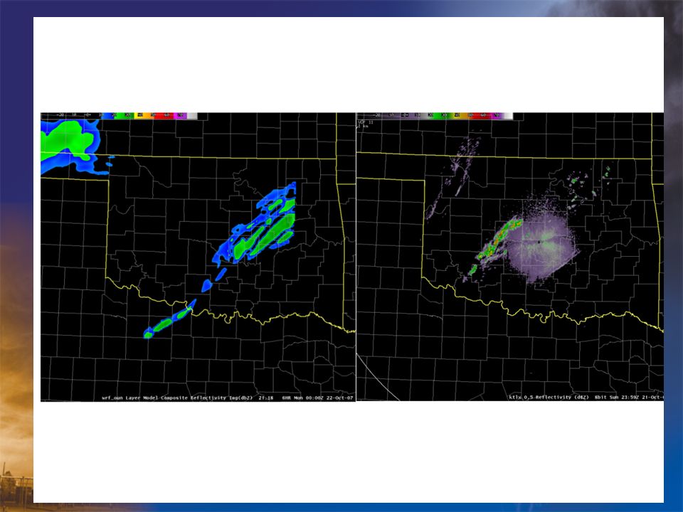
LOCAL WRF MODEL 18Z April 7 2008 Forecast for 23Z

7
450 PM

8
Warn on Forecast in 2020: What might it look like? Forecast looks on track, storm circulation (hook echo) is tracking along centerline of highest tornadic probabilities Radar and Initial Forecast at 2100 CSTRadar at 2130 CST: Accurate Forecast Most Likely Tornado Path T=2120 CST T=2150 T=2130 T=2140 70% 50% 30% T=2200 CST Developing thunderstorm 2 of 5 NSSL Warn on Forecast Briefing March 5, 2007 Most Likely Tornado Path T=2120 CST T=2150 T=2130 T=2140 T=2200 CST An ensemble of storm-scale NWP models predict the path of a potentially tornadic supercell during the next 1 hour. The ensemble is used to create a probabilistic tornado hazard forecast grid. 70% 50% 30% Courtesy Lou Wicker, NSSL
 is tracking along centerline of highest tornadic probabilities Radar and Initial Forecast at 2100 CSTRadar at 2130 CST: Accurate Forecast Most Likely Tornado Path T=2120 CST T=2150 T=2130 T= % 50% 30% T=2200 CST Developing thunderstorm 2 of 5 NSSL Warn on Forecast Briefing March 5, 2007 Most Likely Tornado Path T=2120 CST T=2150 T=2130 T=2140 T=2200 CST An ensemble of storm-scale NWP models predict the path of a potentially tornadic supercell during the next 1 hour. The ensemble is used to create a probabilistic tornado hazard forecast grid. 70% 50% 30% Courtesy Lou Wicker, NSSL.")
9
Alternative Warning and Forecast Formats High temporal- and spatial-resolution probabilistic hazard grids

10
WoF Challenges best approaches to radar data qc and assimilation into models determining how WoF information will be used in NWS operations and communicated to the public storm-scale process understanding, predictability, and parameterization improvements WoF project priorities, timing, evaluation and implementation strategies best approaches to radar data qc and assimilation into models determining how WoF information will be used in NWS operations and communicated to the public storm-scale process understanding, predictability, and parameterization improvements WoF project priorities, timing, evaluation and implementation strategies

11
Some assumptions… WoF will evolve into operations –Not a turn key system –May be regional or local differences in implementation There will remain a detection component –An alert notification will inform of high impact phenomena Science and technology will continue to expand the number of observations, analyses and forecasts WoF will evolve into operations –Not a turn key system –May be regional or local differences in implementation There will remain a detection component –An alert notification will inform of high impact phenomena Science and technology will continue to expand the number of observations, analyses and forecasts

12
…and some more… Data volume and complexity will grow –Dual pol, Phased array, CASA –Ensemble regional, local and storm scale models New forecast and warning formats and dissemination –Hazard probability envelopes Graphical Text –More frequent updates possible –Techniques will require calibration –Techniques will require bias removal Data volume and complexity will grow –Dual pol, Phased array, CASA –Ensemble regional, local and storm scale models New forecast and warning formats and dissemination –Hazard probability envelopes Graphical Text –More frequent updates possible –Techniques will require calibration –Techniques will require bias removal

13
…and more Role of the human expert will change –Today’s warning forecaster processes inputs and makes warning decision –The same process tomorrow will mean many inputs not considered Manage the process –Review –Assess –Correct Many others… Role of the human expert will change –Today’s warning forecaster processes inputs and makes warning decision –The same process tomorrow will mean many inputs not considered Manage the process –Review –Assess –Correct Many others…

14
Things the WFO can do now…

15
Radar data quality control Review and assess radar data in real time Review and assess storm scale analysis in real time Review and assess radar data in real time Review and assess storm scale analysis in real time

16
Information use in operations and communication to users A proving ground for operations –Dedicated WFO position(s) during event operations –Post-event reviews of information and actions –HWT A proving ground for operations –Dedicated WFO position(s) during event operations –Post-event reviews of information and actions –HWT
 during event operations –Post-event reviews of information and actions –HWT A proving ground for operations –Dedicated WFO position(s) during event operations –Post-event reviews of information and actions –HWT")
17
Information use in operations and communication to users A proving ground for information –Graphicasts –Significant weather advisories –Warning decision updates Interact with users groups; EMs, Schools, medical groups, local decision makers, SSWIM A proving ground for information –Graphicasts –Significant weather advisories –Warning decision updates Interact with users groups; EMs, Schools, medical groups, local decision makers, SSWIM

18
Evaluation and implementation strategies Evaluate suitability of storm scale forecasts Risk reduction of phased implementation Evaluate suitability of storm scale forecasts Risk reduction of phased implementation

Similar presentations


 J. Kelly, Jr. National Weather Service Infusion of Satellite.>")


 February 25–27, 2015 National Weather Center>")
 is responsible for forecasts several times.>")


