Download presentation
Presentation is loading. Please wait.

1
Fronts and Mid-latitude Cyclones SOEE 1400 : Lecture 8

2
SOEE1400 : Meteorology and Forecasting : lecture 82 Fronts A boundary between two characteristically different ‘air masses’ is called a front. It is a region of significant horizontal gradients in temperature or humidity. Fronts are typically 100 to 200 km wide – but very sharp transitions are possible over a few km or even hundreds of metres. Fronts are a dominant feature of mid-latitudes. In particular fronts associated with low pressure systems (mid-latitude cyclones, extra-tropical cyclones, depressions). The movement of fronts is responsible for much of the day- to-day variability in weather conditions. Northwest Europe receives many different air mass types, with frequent frontal passages – results in very variable weather.
. The movement of fronts is responsible for much of the day- to-day variability in weather conditions. Northwest Europe receives many different air mass types, with frequent frontal passages – results in very variable weather..")
3
3 Potted history In the 19 th century forecasters believed that cyclone were symmetrical (like tropical cyclones). Margules (1905) first showed how a front could be sustained by the winds blowing along the frontal surface. The ‘frontal cyclone’ model was pioneered by the Bergen school around and just after WWI. This was the beginning of major improvements in quantitative weather prediction – timing of events and prediction of their development. SOEE 1400 : Meteorology and Forecasting : lecture 8
 first showed how a front could be sustained by the winds blowing along the frontal surface. The ‘frontal cyclone’ model was pioneered by the Bergen school around and just after WWI. This was the beginning of major improvements in quantitative weather prediction – timing of events and prediction of their development. SOEE 1400 : Meteorology and Forecasting : lecture 8.")
4
Fronts are found embedded in the “frontal cyclone” ENVI 1400 : Meteorology and Forecasting : lecture 84

5
5 Warm Front warm air cool air movement of front cool air warm air nimbo-stratus alto-stratus cirro-stratus cirrus ~300 km~500 km Warm air flows up over denser cold air Inclination of frontal surface is very shallow: 0.5 to 1 Approach of front signalled by high cirrus or cirrostratus, cloud base lowering as surface front approaches. Rain starts ahead of surface front, is widespread and persistent Skies clear quickly after passage of surface front ~10 km

6
ENVI 1400 : Meteorology and Forecasting : lecture 86 Cumulo- nimbus Cold Front - 1 cold air warm air movement of front cold air warm air ~70 km~200 km Dense cold air pushes forward into warmer air, which is forced upward Steeper than warm front: ~2 or 1/50 Deep convective clouds form above surface front, heavy rain in narrow band along surface front Behind front cloud base lifts, eventually clearing Near the surface the cold air may surge forward, producing a very steep frontal zone ~10 km

7
ENVI 1400 : Meteorology and Forecasting : lecture 87 Cumulo- nimbus Cold Front - 2 cold air warm air movement of front cold air warm air ~70 km~200 km Dense cold air pushes forward into warmer air, and over-runs it. Deep convective clouds form above upper front, heavy rain in narrow band along upper front Between upper and surface fronts, there is shallower cloud. ~10 km

8
ENVI 1400 : Meteorology and Forecasting : lecture 88 Stationary Fronts There is no fundamental difference between the air masses either side of warm and cold fronts – the front is defined by the direction of motion When the boundary between air masses does not move it is called a stationary front Note that the wind speed is not zero – the air individual masses still move, but the boundary between them does not cold air warm air

9
ENVI 1400 : Meteorology and Forecasting : lecture 89 Occluded Fronts movement of front In general cold fronts move faster than warm fronts, and may thus catch up with a warm front ahead – the result is an occluded front There are two types of occluded fronts: warm and cold, depending on whether the air behind the cold front is warmer or cooler than the air ahead of the warm front Warm occlusions are the more common type in the UK Occlusion is part of the cycle of frontal development and decay within mid-latitude low pressure systems

10
ENVI 1400 : Meteorology and Forecasting : lecture 810 Cold, stable air warm air Cool, unstable air Warm Occlusion In both warm and cold occlusions, the wedge of warm air is associated with layered clouds, and frequently with precipitation Precipitation can be heavy if warm moist air is forced up rapidly by the occlusion

11
ENVI 1400 : Meteorology and Forecasting : lecture 811 cold air warm air cool air Cold Occlusion Regarded to be very rare. Some believe that they do not exist (see Schultz and Mass, 1993, Mon. Wea. Rev., 121, 918-940).
..")
12
ENVI 1400 : Meteorology and Forecasting : lecture 812 Mid-latitude Cyclones Low pressure systems are a characteristic feature of mid- latitude temperate zones They form in well defined zones associated with the polar front – which provides a strong temperature gradient – and convergent flow resulting from the global circulation 31-08-2000

13
ENVI 1400 : Meteorology and Forecasting : lecture 813

14
ENVI 1400 : Meteorology and Forecasting : lecture 814 31-08-2000 : 1310 UTC

15
ENVI 1400 : Meteorology and Forecasting : lecture 815 Low pressure forms at surface over “polar front” due to divergence aloft As rotation around initial low starts, a ‘wave’ develops on the polar front Mass balance: inward flow compensated by large-scale lifting cooling cloud formation cloud

16
ENVI 1400 : Meteorology and Forecasting : lecture 816 Surface low is maintained (or deepens) due to divergence aloft exceeding convergence at surface Flow is super-geostrophic: cold sector air pushes cold front forward; warm sector air flows up warm front – warm front moves slower than cold Cold front overtakes warm front to form an occlusion, which works out from centre Depression usually achieves maximum intensity 12-24 hours after the start of occlusion
 due to divergence aloft exceeding convergence at surface Flow is super-geostrophic: cold sector air pushes cold front forward; warm sector air flows up warm front – warm front moves slower than cold Cold front overtakes warm front to form an occlusion, which works out from centre Depression usually achieves maximum intensity hours after the start of occlusion")
17
ENVI 1400 : Meteorology and Forecasting : lecture 817 Low starts to weaken as inflowing air ‘fills up’ the low pressure Low continues to weaken, clouds break up

18
ENVI 1400 : Meteorology and Forecasting : lecture 818

19
ENVI 1400 : Meteorology and Forecasting : lecture 819 A B A B

20
ENVI 1400 : Meteorology and Forecasting : lecture 820 A B A B

21
ENVI 1400 : Meteorology and Forecasting : lecture 821

22
ENVI 1400 : Meteorology and Forecasting : lecture 822 An alternative to the Norwegian model of occlusion Incipient broad-baro-clinic phase (I), frontal fracture (II), bent back front and frontal T-bone (III), and warm core frontal seclusion (IV). Upper: sea level pressure (solid), fronts (bold), Figure and cloud signature (shaded). Lower: temperature (solid), and cold and warm air currents (solid and dashed arrows). Shapiro and Keyser, 1990 Shapiro, M.A. and Keyser, D. (1990).On the structure and dynamics of fronts, jet streams and the tropopause. Extratropical Cyclones: The Erik Palmén Memorial Volume, C. W. Newton and E. O. Holopainen, Eds., Amer. Meteor. Soc., pp.167-191.
, fronts (bold), Figure and cloud signature (shaded). Lower: temperature (solid), and cold and warm air currents (solid and dashed arrows). Shapiro and Keyser, 1990 Shapiro, M.A. and Keyser, D. (1990).On the structure and dynamics of fronts, jet streams and the tropopause. Extratropical Cyclones: The Erik Palmén Memorial Volume, C. W. Newton and E. O. Holopainen, Eds., Amer. Meteor. Soc., pp")
23
ENVI 1400 : Meteorology and Forecasting : lecture 823 Conveyor belts Since the 1970’s, coherent belts of low level winds have been identified ahead of cold and warm fronts. These are important in the transport (“advection”) of atmospheric properties such as heat, moisture and trace gases.
 of atmospheric properties such as heat, moisture and trace gases..")
24
ENVI 1400 : Meteorology and Forecasting : lecture 824 Warm conveyor belt at a cold front (“JET” - directed into the page here)
")
25
ENVI 1400 : Meteorology and Forecasting : lecture 825 Warm conveyor belt at a split cold front (“JET” - directed into the page here)
")
26
ENVI 1400 : Meteorology and Forecasting : lecture 826 Cold conveyor belt at a warm front (“JET” - directed into the page here)
")
27
ENVI 1400 : Meteorology and Forecasting : lecture 827 Warm and cold conveyor belts (WCB and CCB) in a frontal cyclone
 in a frontal cyclone")
28
ENVI 1400 : Meteorology and Forecasting : lecture 828

29
ENVI 1400 : Meteorology and Forecasting : lecture 829 Infra-red image of the cyclone

30
ENVI 1400 : Meteorology and Forecasting : lecture 830 upper wind A B C D

31
ENVI 1400 : Meteorology and Forecasting : lecture 831 Crossed-Winds Rule If an observer stands with their back to the surface wind and estimates the direction of the upper-level winds from motion of high-level clouds, they can a) estimate their position within a low pressure system, and hence b) make a rough forecast: –If upper wind from your LEFT (position A), the weather is likely to deteriorate –If upper wind from you RIGHT (position B), the weather is likely to improve –If upper wind is BEHIND or AHEAD of you (positions C, D), there is likely to be little change in the weather
 estimate their position within a low pressure system, and hence b) make a rough forecast: –If upper wind from your LEFT (position A), the weather is likely to deteriorate –If upper wind from you RIGHT (position B), the weather is likely to improve –If upper wind is BEHIND or AHEAD of you (positions C, D), there is likely to be little change in the weather")
32
The “sting in the tail” Highest winds are often observed to the SW of a secluded Keyser-Shapiro cyclone (bottom right panels). Graham Parton PhD and QJRMetS paper: statistics of UK windstorms relative to frontal cyclones. ENVI 1400 : Meteorology and Forecasting : lecture 832

33
The CCB and the sting jet Shapiro-Keyser cyclone, with warm seclusion. High winds in the CCB (“CJ” here) in the SW part of the cyclone, on the cold side. Sting Jet on the warm side – short-lived, very intense winds. SOEE 1400 : Meteorology and Forecasting : lecture 833
 in the SW part of the cyclone, on the cold side. Sting Jet on the warm side – short-lived, very intense winds. SOEE 1400 : Meteorology and Forecasting : lecture 833.")
34
Examples of... Sting Jets in European Windstorms Tim Baker, Peter Knippertz & Alan Blyth

35
Cyclone Friedhelm 08 December 2011

36
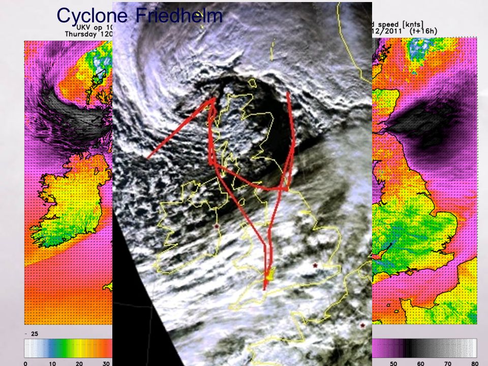
Cyclone Friedhelm

38
Cyclone Friedhelm shows obvious banded structure in the cloud ahead of the main cloud head. Evidence from analysis of the Met Office UM suggests numerous sting jets may have occurred over Scotland. Baker et al, 2013

39
Cyclone Zafer 01 December 2011

40
Cyclone Zafer

41
VIDEO

42
Cyclone Zafer Sections from the dropsonde leg show two maxima in the wind speed. This could be evidence of a sting jet similar to that seen in Cyclone Ulli. More analysis and modelling is needed to confirm this. Courtesy of Geraint Vaughan, NCAS/Uni. of Manchester

43
The “sting in the tail”: references Observational investigation of the Great Storm of October 1987 (Browning K.A., 2004, Q.J.R.Meteorol. Soc.) Investigation of the3-D Structure of the Sting Jet with a high-resolution NWP- Model (Clark P.A., K.A. Browning and C. Wang, 2005, Q.J.R.Meteorol. Soc.) ENVI 1400 : Meteorology and Forecasting : lecture 843
 Investigation of the3-D Structure of the Sting Jet with a high-resolution NWP- Model (Clark P.A., K.A. Browning and C. Wang, 2005, Q.J.R.Meteorol. Soc.) ENVI 1400 : Meteorology and Forecasting : lecture 843.")
Similar presentations


 in the tropics Air cools and sinks in the subtropics (deserts) Poleward-flow is deflected.>")


>")


