Download presentation
Presentation is loading. Please wait.

1
Hydrologic Information Systems to discover and combine data from multiple sources for hydrologic analysis David Tarboton Utah State University Support EAR 0622374 CUAHSI HIS Sharing hydrologic data http://his.cuahsi.org/

2
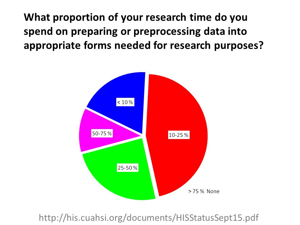
What proportion of your research time do you spend on preparing or preprocessing data into appropriate forms needed for research purposes? http://his.cuahsi.org/documents/HISStatusSept15.pdf
3
HydroServer – Data Publication Lake Powell Inflow and Storage HydroDesktop – Data Access and Analysis HydroDesktop – Combining multiple data sources HydroCatalog Data Discovery CUAHSI HIS The CUAHSI Hydrologic Information System (HIS) is an internet based system to support the sharing of hydrologic data. It is comprised of hydrologic databases and servers connected through web services as well as software for data publication, discovery and access.

4
University of Texas at Austin – David Maidment, Tim Whiteaker, James Seppi, Fernando Salas, Jingqi Dong, Harish Sangireddy San Diego Supercomputer Center – Ilya Zaslavsky, David Valentine, Tom Whitenack, Matt Rodriguez Utah State University – David Tarboton, Jeff Horsburgh, Kim Schreuders, Stephanie Reeder University of South Carolina – Jon Goodall, Anthony Castronova Idaho State University – Dan Ames, Ted Dunsford, Jiří Kadlec, Yang Cao, Dinesh Grover Drexel University/CUNY – Michael Piasecki CUAHSI Program Office – Rick Hooper, Yoori Choi, Jennifer Arrigo, Conrad Matiuk ESRI – Dean Djokic, Zichuan Ye Users Committee – Kathleen Mckee, Jim Nelson, Stephen Brown, Lucy Marshall, Chris Graham, Marian Muste Support EAR 0622374 CUAHSI HIS Sharing hydrologic data http://his.cuahsi.org/ The CUAHSI Hydrologic Information System Team

5
CUAHSI is a consortium representing 125 US universities (plus international affiliate members) Supported by the National Science Foundation Earth Science Division Advances hydrologic science in nation’s universities Projects in Informatics, Instrumentation, Observatories, Synthesis, and Research Applications http://www.cuahsi.org What is CUAHSI?
 Supported by the National Science Foundation Earth Science Division Advances hydrologic science in nation’s universities Projects in Informatics, Instrumentation, Observatories, Synthesis, and Research Applications What is CUAHSI")
6
Hydrologic Data Challenges From dispersed federal agencies From investigators collected for different purposes Different formats – Points – Lines – Polygons – Fields – Time Series Rainfall and Meteorology Water quantity Soil water Groundwater Water quality GIS Data Heterogeneity The way that data is organized can enhance or inhibit the analysis that can be done

7
I have your information right here … Picture from: http://initsspace.com/

8
Hydrologic Science Hydrologic conditions (Fluxes, flows, concentrations) Hydrologic Process Science (Equations, simulation models, prediction) Hydrologic Information Science (Observations, data models, visualization Hydrologic environment (Physical earth) Physical laws and principles (Mass, momentum, energy, chemistry) It is as important to represent hydrologic environments precisely with data as it is to represent hydrologic processes with equations
 Hydrologic Process Science (Equations, simulation models, prediction) Hydrologic Information Science (Observations, data models, visualization Hydrologic environment (Physical earth) Physical laws and principles (Mass, momentum, energy, chemistry) It is as important to represent hydrologic environments precisely with data as it is to represent hydrologic processes with equations")
9
Data models capture the complexity of natural systems NetCDF (Unidata) - A model for Continuous Space-Time data Space, L Time, T Variables, V D Coordinate dimensions {X} Variable dimensions {Y} ArcHydro – A model for Discrete Space-Time Data Space, FeatureID Time, TSDateTime Variables, TSTypeID TSValue Terrain Flow Data Model used to enrich the information content of a digital elevation model CUAHSI Observations Data Model: What are the basic attributes to be associated with each single data value and how can these best be organized?
 - A model for Continuous Space-Time data Space, L Time, T Variables, V D Coordinate dimensions {X} Variable dimensions {Y} ArcHydro – A model for Discrete Space-Time Data Space, FeatureID Time, TSDateTime Variables, TSTypeID TSValue Terrain Flow Data Model used to enrich the information content of a digital elevation model CUAHSI Observations Data Model: What are the basic attributes to be associated with each single data value and how can these best be organized")
10
Data Searching – What we used to have to do NWIS NARR NAWQA NAM-12 request request return return Searching each data source separately Michael Piasecki Drexel University

11
What HIS enables Searching all data sources collectively NWIS NAWQA NARR generic request GetValues GetValues ODM Michael Piasecki Drexel University

12
Video Demo http://his.cuahsi.org/movies/JacobsWellSpring/JacobsWellSpring.html

13
Catalog (Google) Web Server (CNN.com) Browser (Firefox) Access Catalog harvest Search Web Paradigm
 Web Server (CNN.com) Browser (Firefox) Access Catalog harvest Search Web Paradigm")
14
Data Discovery and Integration Data Publication Data Analysis and Synthesis HydroCatalog HydroDesktopHydroServer ODMGeo Data CUAHSI Hydrologic Information System Services-Oriented Architecture Data Services Metadata Services Search Services WaterML, Other OGC Standards Information Model and Community Support Infrastructure

15
What are the basic attributes to be associated with each single data value and how can these best be organized? Space, S Time, T Variables, V s t ViVi v i (s,t) “Where” “What” “When” A data value Variable Method Quality Control Level Sample Medium Value Type Data Type Source/Organization Units Accuracy Censoring Qualifying comments Location Feature of interest Latitude Longitude Site identifiers DateTime Interval (support)
 Where What When A data value Variable Method Quality Control Level Sample Medium Value Type Data Type Source/Organization Units Accuracy Censoring Qualifying comments Location Feature of interest Latitude Longitude Site identifiers DateTime Interval (support).")
16
Observations Data Model (ODM) Soil moisture data Streamflow Flux tower data Groundwater levels Water Quality Precipitation & Climate A relational database at the single observation level Metadata for unambiguous interpretation Traceable heritage from raw measurements to usable information Promote syntactic and semantic consistency Cross dimension retrieval and analysis Horsburgh, J. S., D. G. Tarboton, D. R. Maidment, and I. Zaslavsky (2008), A relational model for environmental and water resources data, Water Resources Research, 44, W05406, doi:10.1029/2007WR006392. Provides a common persistence model for data storage
, A relational model for environmental and water resources data, Water Resources Research, 44, W05406, doi: /2007WR Provides a common persistence model for data storage.")
17
Horsburgh, J. S., D. G. Tarboton, D. R. Maidment and I. Zaslavsky, (2008), A Relational Model for Environmental and Water Resources Data, Water Resour. Res., 44: W05406, doi:10.1029/2007WR006392. CUAHSI Observations Data Model http://his.cuahsi.org/odmdatabases.htmlhttp://his.cuahsi.org/odmdatabases.html
, A Relational Model for Environmental and Water Resources Data, Water Resour. Res., 44: W05406, doi: /2007WR CUAHSI Observations Data Model")
18
Discharge, Stage, Concentration and Daily Average Example

19
Site Attributes SiteCode, e.g. NWIS:10109000 SiteName, e.g. Logan River Near Logan, UT Latitude, Longitude Geographic coordinates of site LatLongDatum Spatial reference system of latitude and longitude Elevation_m Elevation of the site VerticalDatum Datum of the site elevation Local X, Local Y Local coordinates of site LocalProjection Spatial reference system of local coordinates PosAccuracy_m Positional Accuracy State, e.g. Utah County, e.g. Cache

20
1 1 CouplingTable SiteID HydroID Sites SiteID SiteCode SiteName Latitude Longitude … Observations Data Model 1 1 OR Independent of, but can be coupled to Geographic Representation ODM e.g. Arc Hydro

21
Stage and Streamflow Example

22
Water Chemistry from a profile in a lake

23
Loading data into ODM Interactive OD Data Loader (OD Loader) –Loads data from spreadsheets and comma separated tables in simple format Scheduled Data Loader (SDL) –Loads data from datalogger files on a prescribed schedule. –Interactive configuration SQL Server Integration Services (SSIS) –Microsoft application accompanying SQL Server useful for programming complex loading or data management functions OD Data Loader SDL SSIS
 –Microsoft application accompanying SQL Server useful for programming complex loading or data management functions OD Data Loader SDL SSIS.")
24
Importance of the Observations Data Model Provides a common persistence model for observations data Syntactic consistency (File types and formats) Semantic consistency – Language for observation attributes (structural) – Language to encode observation attribute values (contextual) Publishing and sharing research data Metadata to facilitate unambiguous interpretation Enhance analysis capability 24
 Semantic consistency – Language for observation attributes (structural) – Language to encode observation attribute values (contextual) Publishing and sharing research data Metadata to facilitate unambiguous interpretation Enhance analysis capability 24")
25
Set of query functionsReturns data in WaterML WaterML and WaterOneFlow WaterML is an XML language for communicating water data WaterOneFlow is a set of web services based on WaterML GetSites WaterOneFlow Web Service GetValues GetSiteInfo GetVariableInfo

26
http://www.opengeospatial.org/standards/waterml Open Geospatial Consortium Web Service Standards This document is an OGC® Encoding Standard for the representation of hydrological observations data with a specific focus on time series structures. These standards have been developed over the past 10 years …. by 400 companies and agencies....

27
Feature of Interest Procedure (ID := “DAVIS_123“) 23 m/s 16.9.2010 13:45 Result uom Sampling Time Observed Property := “Wind_Speed“ Observation Sensor Observations Service: Get Observation
 23 m/s :45 Result uom Sampling Time Observed Property := Wind_Speed Observation Sensor Observations Service: Get Observation")
28
Ongoing Data Collection Data presentation, visualization, and analysis through Internet enabled applications Internet Applications Point Observations Data Historical Data Files GIS Data ODM Database GetSites GetSiteInfo GetVariableInfo GetValues WaterOneFlow Web Service WaterML HydroServer – Data Publication OGC Spatial Data Service from ArcGIS Server

29
HydroCatalog GetSites GetSiteInfo GetVariableInfo GetValues WaterOneFlow Web Service WaterML Discovery and Access Hydro Desktop Water Metadata Catalog Harvester Service RegistryHydrotagger Search Services http://hiscentral.cuahsi.org Search over data services from multiple sources Supports concept based data discovery CUAHSI Data Server 3 rd Party Server e.g. USGS

30
Overcoming Semantic Heterogeneity ODM Controlled Vocabulary System –ODM CV central database –Online submission and editing of CV terms –Web services for broadcasting CVs Variable Name Investigator 1:“Temperature, water” Investigator 2:“Water Temperature” Investigator 3:“Temperature” Investigator 4:“Temp.” ODM VariableNameCV Term … Sunshine duration Temperature Turbidity … From Jeff Horsburgh

31
Dynamic controlled vocabulary moderation system Local ODM Database Master ODM Controlled Vocabulary ODM Website ODM Controlled Vocabulary Moderator ODM Data Manager ODM Controlled Vocabulary Web Services ODM Tools Local Server XML http://his.cuahsi.org/mastercvreg.html From Jeff Horsburgh

32
Thematic keyword search Integration from multiple sources Search on space and time domain HydroDesktop – Data Access and Analysis

33
HydroModeler An integrated modeling environment based on the Open Modeling Interface (OpenMI) standard and embedded within HydroDesktop Integrated modeling within a Hydrologic Information System: An OpenMI based approach, Castronova, A.M., Goodall, J.L., Ercan, M,B. Environmental Modelling & Software, In Press. 10.1016/j.envsoft.2012.02.011.

34
Service Orientation of Hydrologic Models A service-oriented modeling approach is needed to overcome platform dependencies, computer architecture requirements, or programming language incompatibilities that exist between models within an integrated software system. Models are designed as web resources using the PyWPS implementation of the OGC WPS data specification on a RESTful web server. Service orientation involves decomposing a larger software system into independent distributed components. The client-server interaction (above) is very similar to the loose integration paradigm. 1. Client Wrapper – generic OpenMI component for wrapping web resources on-the-fly 2. WPS Services – models implemented as WPS resources Models as web services using the Open Geospatial Consortium (OGC) Web Processing Service (WPS) standard, Castronova, A. M., Goodall, J. L., Elag, M.M., Environmental Modelling & Software, In Review
 is very similar to the loose integration paradigm. 1. Client Wrapper – generic OpenMI component for wrapping web resources on-the-fly 2. WPS Services – models implemented as WPS resources Models as web services using the Open Geospatial Consortium (OGC) Web Processing Service (WPS) standard, Castronova, A. M., Goodall, J. L., Elag, M.M., Environmental Modelling & Software, In Review.")
35
Integration with “R” Statistics Package

36
A growing collection of HydroServers and community of users Dry Creek Experimental Watershed (DCEW) (28 km 2 semi-arid steep topography, Boise Front) 68 Sites 24 Variables 4,700,000+ values Published by Jim McNamara, Boise State University University of Maryland, Baltimore County Montana State University University of Texas at Austin University of Iowa Utah State University University of Florida University of New Mexico University of Idaho Boise State University University of Texas at Arlington University of California, San Diego Idaho State University
 (28 km 2 semi-arid steep topography, Boise Front) 68 Sites 24 Variables 4,700,000+ values Published by Jim McNamara, Boise State University University of Maryland, Baltimore County Montana State University University of Texas at Austin University of Iowa Utah State University University of Florida University of New Mexico University of Idaho Boise State University University of Texas at Arlington University of California, San Diego Idaho State University")
37
Open Development Model http://hydrodesktop.codeplex.com http://hydroserver.codeplex.com http://hydrocatalog.codeplex.com

38
General aspects of the approach Storage in a community data model Publication from a server Data access through internet- based services using consistent language and format Tools for access and analysis Discovery through thematic and geographic search functionality Integrated modeling and analysis combining information from multiple sources Discovery and Integration Data Services Catalog Synthesis and Research Desktop/Client Publication Server Metadata Services Search Services Standards Information Model and Community Support Infrastructure Accessibility Discoverability Consumability Common functional components The combination of these capabilities creates a common window on water observations data for the United States unlike any that has existed before.

39
Looking to the Future Move from prototype to operations – Operational support of software and systems – User support and training – Repositories – CUAHSI Data Center Hydroshare – An online, environment to be developed for the sharing of hydrologic data and models – To expand data sharing capability of CUAHSI HIS Additional data classes Models, scripts, tools and workflows Collaboration/social networking Community – HIS has become bigger than one project – Open Development Model to coordinate community contributions

40
HydroShare VisualizationSocial Media Data Models Data.gov Earth Exchange HPC CSDMS CUAHSI HydroServer Create Read Update Delete WPS HydroDesktop Collaboration Your favorite...

41
Can sharing data and models be as easy as sharing photos on Facebook or videos on YouTube?

42
Can finding data and models be as easy as shopping on Amazon? Items Possible Filters Available Formats Recommendations Prices (perhaps usage)
.")
43
Sign In | Settings | Notifications | Feedback | Help Dashboard Recent Activity My Content View Your Resources Explore Discover Resources Collaborate Share with colleagues Getting Started What’s New Provide feedback HydroShare Blog Developers Partners HydroShare GalleryHow HydroShare WorksGetting Started CUAHSI CUAHSI HIS CUAHSI Water Data Center Share and Collaborate HydroShare is an online collaboration environment for sharing data, models, and code. Join the community to start sharing. Terms of Use | Statement of Privacy| Copyright © 2012 CUAHSI This material is based upon work supported by the National Science Foundation (NSF) under Grants No. OCI-1148453, OCI-1148090 Any opinions, findings, conclusions, or recommendations expressed in this material are those of the authors and do not necessarily reflect the views of the NSF. HYDROSHARE
 under Grants No. OCI , OCI Any opinions, findings, conclusions, or recommendations expressed in this material are those of the authors and do not necessarily reflect the views of the NSF. HYDROSHARE.")
44
Dashboard Recent Activity My Content View Your Resources Explore Discover Resources Collaborate Share with colleagues Recent ActivityProfile All activity | Only my activity More Jeff Horsburgh Utah State University jeff.horsburgh@usu.edu Resources You May Like You Should Follow Announcements People | Groups Jeff Horsburgh Utah State University David Tarboton Utah State University Little Bear River ODM Database 6/6/2012 View Details Abstract: Time series of water quality sensor data in the Little Bear River, Utah, USA Keywords: Temperature, Dissolved Oxygen, pH, Specific Conductance, Turbidity What’s New at HydroShare: Click here to visit the HydroShare blog to learn more about recent updates and new HydroShare features. Little Bear River Sites 6/6/2012 Little Bear River Excel File 6/6/2012 Watershed delineation Workflow 6/6/2012 Little Bear River SWAT Model Shared by: David Tarboton Little Bear River DEM Shared by: David Tarboton You are signed in as Jeff Horsburgh | Settings | Notifications | Feedback | Help Terms of Use | Statement of Privacy| Copyright © 2012 CUAHSI This material is based upon work supported by the National Science Foundation (NSF) under Grants No. OCI-1148453, OCI-1148090 Any opinions, findings, conclusions, or recommendations expressed in this material are those of the authors and do not necessarily reflect the views of the NSF. HYDROSHARE
 under Grants No. OCI , OCI Any opinions, findings, conclusions, or recommendations expressed in this material are those of the authors and do not necessarily reflect the views of the NSF. HYDROSHARE.")
45
Architecture HydroShare Portal Browser Interface Dashboard, Explore, Visualization, Modeling, Collaborate, Support Service Interface Discovery API calls Create resource API Read resource API Update resource API Delete resource API Modeling API R, MATLAB, HydroDesktop, ArcGIS, IDV, Python Management Interface (Browser) Configure Set permissions External Resource Interface External Catalog (e.g. HydroCatalog) External Data Sources HPC Cluster Authentication and Access control Resource Catalog External Internal Resource Store Objects Rules Users Visualization Tools Modeling Tools Social Media Data and information Social Media Discovery Tools Resource Data Model (Information about resources that are stored) Full metadata Data cart metadata Data discovery metadata Data Model for Models (Information Models and What it takes to run them on available compute resources) Many details to work out Model Store Model Metadata Models Desktop Compute Resources
 External Data Sources HPC Cluster Authentication and Access control Resource Catalog External Internal Resource Store Objects Rules Users Visualization Tools Modeling Tools Social Media Data and information Social Media Discovery Tools Resource Data Model (Information about resources that are stored) Full metadata Data cart metadata Data discovery metadata Data Model for Models (Information Models and What it takes to run them on available compute resources) Many details to work out Model Store Model Metadata Models Desktop Compute Resources.")
46
Summary Simple and easy to use Data and model sharing enabled by open standards based metadata Find, create, share, connect, interact, work together online Archive data collections accompanying research publications in easily accessible way Integration and synthesis across data collections To participate See http://his.cuahsi.orghttp://his.cuahsi.org Join his@sdsc.eduhis@sdsc.edu Write dtarb@usu.edudtarb@usu.edu Questions ? Share Your Resources Explore Discover Resources Collaborate Interact with colleagues Terms of Use | Statement of Privacy| Copyright © 2012 CUAHSI This material is based upon work supported by the National Science Foundation (NSF) under Grants No. OCI-1148453, OCI-1148090 Any opinions, findings, conclusions, or recommendations expressed in this material are those of the authors and do not necessarily reflect the views of the NSF. You are signed in as David Tarboton | Settings | Notifications | Feedback | Help HYDROSHARE
 under Grants No. OCI , OCI Any opinions, findings, conclusions, or recommendations expressed in this material are those of the authors and do not necessarily reflect the views of the NSF. You are signed in as David Tarboton | Settings | Notifications | Feedback | Help HYDROSHARE.")
Similar presentations


,>")
, Tim Whiteaker, Ilya Zaslavsky, Michael.>")


>")


