Download presentation
Presentation is loading. Please wait.

1
Discovery Lecture, Dept. of Earth and Atmospheric Sciences, Purdue University February 28, 2005 Prof. Larry Braile, braile@purdue.edu, www.eas.purdue.edu/~braile (Despite the popularity of this image, tsunami waves do not normally look like this.) The M9.0 Andaman Islands- Sumatra Earthquake and Tsunami of 26 December 2004
 The M9.0 Andaman Islands- Sumatra Earthquake and Tsunami of 26 December")
2
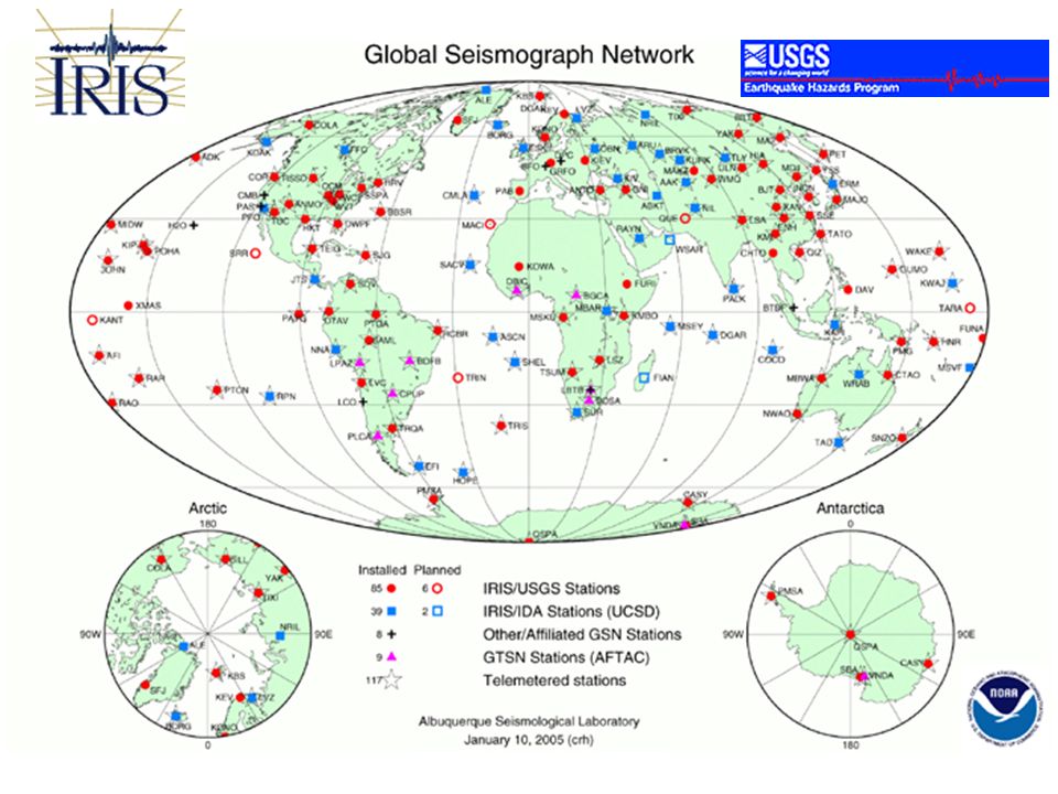
Tectonic Setting USGS

3
Schematic plate tectonic setting for tsunami generation NOAA Commonly, in mega-thrust earthquakes, a very large area of the ocean floor is uplifted TRENCH

4
Historical Seismicity (Indonesia is one of the most seismically active areas in the world, has a long subduction zone plate boundary, and many 7+ earthquakes have occurred there in the past, so it should be no surprise that an M9+ tsunami- generating event would occur there.)
")
5
Question: What other great (M > 8) earthquakes have occurred in the region? Answer: Since 1900 and prior to the December 26 earthquake, the largest earthquake along the subduction zone from southern Sumatra to the Andaman Islands occurred in 2000 and had a magnitude of 7.9. A magnitude 8.4 earthquake occurred in 1797, a magnitude 8.5 in 1861 and a magnitude 8.7 in 1833. All three ruptured sections of the subduction zone to the south of the recent earthquake. Interestingly, the 1797 and 1833 quakes are believed to have ruptured roughly the same area with only 36 years separating the events. Paleoseismic evidence shows that great earthquakes or earthquake couplets occur about every 230 years (http://www.gps.caltech.edu/~sieh/publications/a10.html). USGS Sumatra earthquakes FAQs

6
Show earthquake activity in Indonesia and aftershocks of the 26 December earthquake using the Seismic Eruption program (written by Alan Jones, SUNY- Binghamton) http://www.geol.binghamton.edu/faculty/jones/
")
7
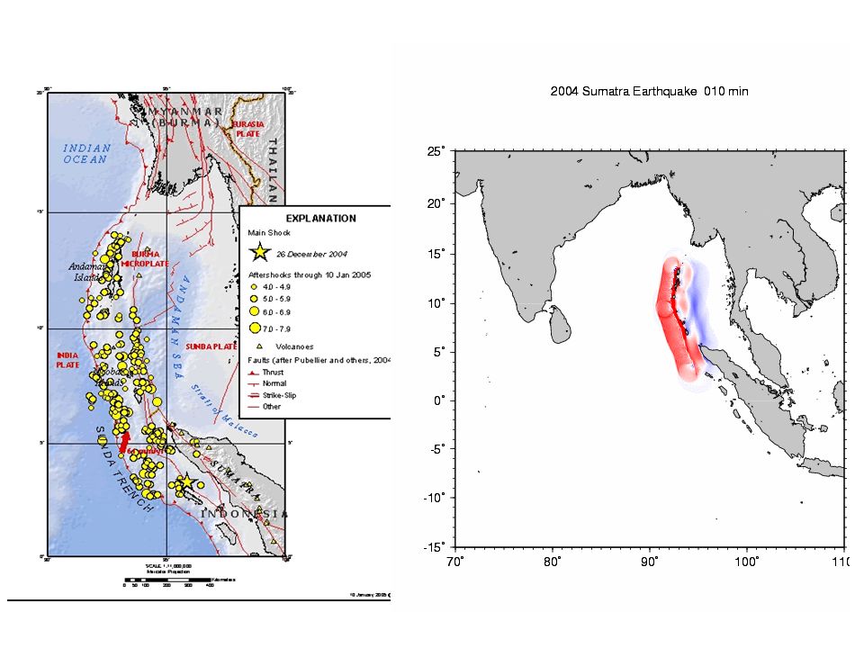
USGS Main shock and aftershocks ~1200 km of the plate boundary moved, max. displacement ~ 15 m (?, preliminary est.)
.")
8
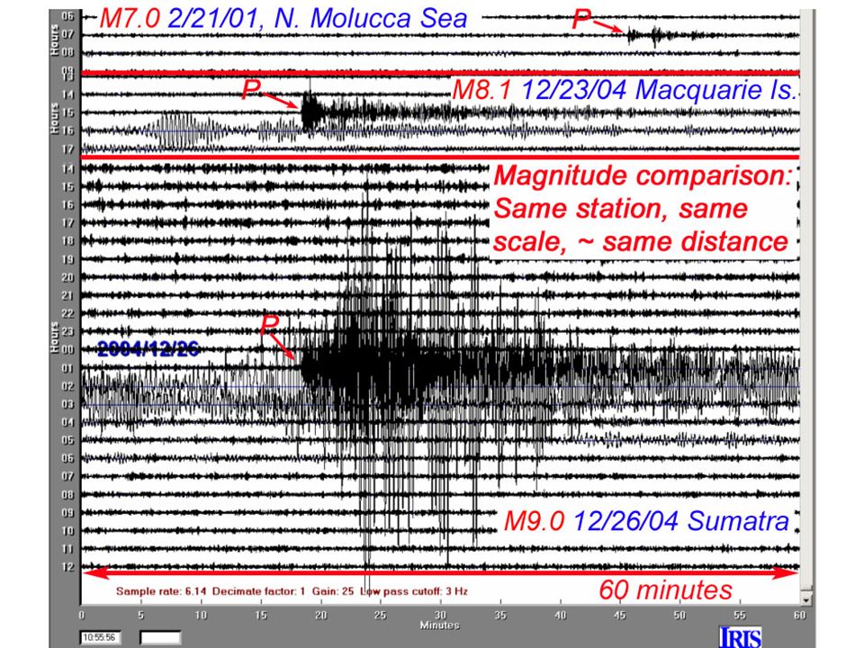
24-hour seismograph record ~135 degrees distance

9
Seismogram

10
Surface waves around the world

11
DescriptorMagnitudeAverage Annually Great8 and higher1 ¹ Major7 - 7.917 ² Strong6 - 6.9134 ² Moderate5 - 5.91319 ² Light4 - 4.913,000 (est.) Minor3 - 3.9130,000 (est.) Very Minor2 - 2.91,300,000 (est.) ¹ Based on observations since 1900. ² Based on observations since 1990. Worldwide earthquakes per year (from USGS):
:.")
12
Worldwide earthquakes per year: Frequency-magnitude relationship suggests that magnitude 9+ events will occur about once per decade; statistically, since 1900, the actual number is ~once per 20 years.

14
Magnitude of earthquake is controlled by fault length that ruptures (data for diagram generated using Seismic/Eruption program) Magnitude versus fault length (determined from aftershock zone length) for various earthquakes (Alaska, 1964; Denali, 2002; Landers, 1992; Loma Prieta, 1989; Northridge, 1994, etc.). Results were quickly obtained using Seismic/Eruption views. Alaska, 1964 Denali, 2002 Landers, 1992 Sumatra, 2004

15
Largest earthquakes, 1900 - 2004 USGS

16
LocationDate UTCMagnitude Coordinates 1. Chile 1960 05 229.538.24 S73.05 W 2. Prince William Sound, Alaska 1964 03 289.261.02 N147.65 W 3. Andreanof Islands, Alaska 1957 03 099.151.56 N175.39 W 4. Kamchatka 1952 11 049.052.76 N160.06 E 5. Off the West Coast of Northern Sumatra 2004 12 269.03.30 N95.78 E 6. Off the Coast of Ecuador 1906 01 318.81.0 N81.5 W 7. Rat Islands, Alaska 1965 02 048.751.21 N178.50 E 8. Assam - Tibet 1950 08 158.628.5 N96.5 E 9. Kamchatka 1923 02 038.554.0 N161.0 E 10. Banda Sea, Indonesia 1938 02 018.55.05 S131.62 E 11. Kuril Islands 1963 10 138.544.9 N149.6 E Largest earthquakes, 1900 - 2004 USGS

18
DateMagn.Max HtKilledLocationComments 9-2-927.210 m170NicaraguaMeasured Pacific-wide 12-12-927.526 m1000 Flores Island 7-12-937.630 m200Hokkaido 6-2-947.214 m220Java 10-4-948.111 m11 Kuril Islands Measured Pacific-wide 11-14-947.17 m70Mindoro 02-21-967.55 m12Peru 07-17-987.015 m2000 New Guinea 06-23-018.35 m50PeruMeasured Pacific-wide Some recent Tsunamis NOAA

19
DateMagn. Max. Ht. KilledLocationComments 5-22-17827.010 m40000Taiwan 11-22-18157.0?10253Indonesia 8-27-1883 -35 m36000Indonesia Krakatau Eruption 1-21-19176.5?15000Indonesia 4-1-19467.935 m173Aleutians Many deaths in Hilo, Hawaii 5-22-19609.525 m534Chile Largest historical earthquake 3-28-19649.267 m115Alaska 2-4-19767.5?22778Guatemala 12-26-20049.015 m ~217,000 (4/8/05 est.) N. Sumatra Greatest number of fatalities Some Notable Tsunamis
 N. Sumatra Greatest number of fatalities Some Notable Tsunamis.")
20
Question: What other significant tsunamis have occurred in the region? Answer: The following destructive tsunamis are listed on a data base maintained by the Tsunami Laboratory, Institute of Computational Mathematics and Mathematical Geophysics (http://tsun.sscc.ru/tsulab/20041226tsun.htm) 1. 1797/02/10 Central part of the western Sumatra. The quake was most felt near Padang and in the area within +/-2 deg of equator. Padang was flooded by powerful waves. More then 300 fatalities. 2. 1833/11/24 South coast of the western Sumatra, estimated rupture from 1 S to 6 S latitude. Huge tidal wave flooded all southern part of the western Sumatra. Numerous victims. 3. 1843/01/05 Strong earthquake west of the central Sumatra. Terrible wave came from the south-east and flooded all the coast of the Nias Island. Many fatalities. 4. 1861/02/16 Exceptionally strong earthquake affected all the western coast of Sumatra. Several thousand fatalities. 5. 1883 Krakatau explosion 36,000 fatalities USGS

21
Tsunami travel time (hours; simulation) NOAA
 NOAA")
22
Tsunami wave height (cm; simulation) NOAA
 NOAA")
23
Tsunami wave height (2 hours after earthquake) measured from satellite radar altimetry NOAA
 measured from satellite radar altimetry NOAA")
24
Satellite radar altimetry

25
Gower, J., EOS, v. 86, no. 4, 25 January, 2005

26
Tsunami wave propagation characteristics – note that as water depth becomes smaller, waves slow down, become shorter wavelength, and have larger amplitude When the water is 10 m deep, what is the separation of the waves in minutes? NOAA

27
Animation courtesy of Dr. Dan Russell, Kettering University http://www.gmi.edu/~drussell/demos.html Water waves animation Direction of propagation

28
Tsunami simulation http://staff.aist.go.jp/kenji.satake/animation.gif

29
Tsunami simulations Open Quick Time simulations (see these websites) http://www.pmel.noaa.gov/tsunami/ http://www.pmel.noaa.gov/tsunami/Mov/TITOV- INDO2004.mov http://es.ucsc.edu/~ward/indo.mov Note distance of propagation and reflection of waves
 INDO2004.mov Note distance of propagation and reflection of waves")
30
Double click on the file: TITOV-INDO2004[1].mov To view Quick Time movie of Tsunami simulation from NOAA http://www.pmel.noaa.gov/tsunami/Mov/TITOV-INDO2004.mov Also, simulation from S. Ward, UCSC: indo[1].mov http://es.ucsc.edu/~ward/indo.mov
![Double click on the file: TITOV-INDO2004[1].mov To view Quick Time movie of Tsunami simulation from NOAA Also, simulation from S.](http://images.slideplayer.com/25/7692532/slides/slide_30.jpg "Ward, UCSC: indo[1].mov")
31
Show video segments of tsunami waves and damage Source: http://www.asiantsunamivideos.com/ http://www.asiantsunamivideos.com/

33
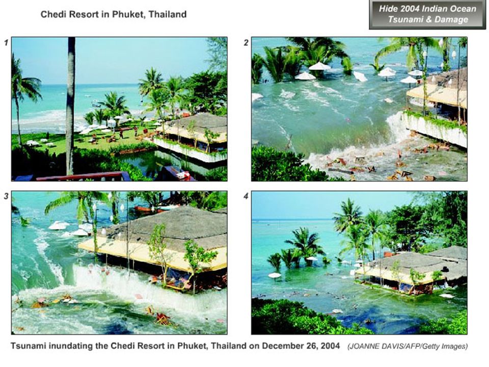
Chedi Resort, Phuket, Thailand, Wave height ~4+ m (?, from estimates of water level from beach umbrellas on grassy area above the beach)
")
34
Damage in Banda Aceh

35
Earthquake and Tsunami Damage, Banda Aceh, Sumatra

36
Earthquake and Tsunami Damage, Sri Lanka

37
Tsunami wave trough, Sri Lanka coast

38
Commonly, the water recedes (a wave trough) significantly for a few minutes before the first wave crest arrives. People often go out to explore the beach or gather fish or shells at that time.

39
Tsunami wave, Sri Lanka; note strong current

40
Banda Aceh, Sumatra, before tsunami http://geo-world.org/tsunami/

41
Banda Aceh, Sumatra, after tsunami Also: http://www.digitalglobe.com/http://www.digitalglobe.com/

42
Factors that increased loss of life and damage 1. Magnitude of earthquake – largest event in 40 years; and location near highly populated coastlines. 2. Approximately north-south orientation of the plate boundary that focused energy to the west and east.

44
3. Location off the coast of Sumatra (?) N. Sumatra west coast S. Am.
 N. Sumatra west coast S. Am.")
45
4. the lack of a tsunami warning system and adequate rapid communication systems

46
DART tsunami warning system NOAA DART: Deep ocean Assessment and Reporting of Tsunamis

47
5. the lack of adequate public awareness of tsunamis and tsunami hazards (Although the 26 December 2004 earthquake and tsunami was a tragic event, two benefits are: that countries are now committed to installing effective tsunami warning systems worldwide, and, there is greatly increased public awareness of tsunamis and tsunami hazards.)
.")
48
Many people watched the waves approach and did not take action until too late, or went out to explore the beach during a wave trough

49
6. the common building construction characteristics in developing countries

50
Some significant observations and occurrences Tsunami warning system could have saved many lives (many deaths occurred as tsunami hit over two hours after the earthquake). In Sumatra, experiencing the strong earthquake caused some people to move to higher ground; however, many did not. Apparently, many animals sensed the seismic waves, the sound of the tsunami waves approaching, or the vibration of the ground caused by crashing ocean waves, and moved to higher ground. Many people watched the waves approach or went out to explore the beach during a wave trough (receding water). A 10-year old girl is credited with saving about 100 people on a beach in Thailand when she noticed the water receding suddenly and told her mother that it looked like a Tsunami was approaching – a lesson that she had recently learned in school.
. A 10-year old girl is credited with saving about 100 people on a beach in Thailand when she noticed the water receding suddenly and told her mother that it looked like a Tsunami was approaching – a lesson that she had recently learned in school..")
51
Earthquake and Tsunami Safety Earthquake safety – “Duck and cover”. Tsunami safety (when in a coastal, near-sea-level area; two situations, local EQ or distant EQ): If you feel strong shaking for 15+ seconds, after shaking, move to higher ground. If there is a tsunami warning, or if you observe unusual waves (appear to be large and rapid tidal changes, or water recedes), move to higher ground. Do not return until event is over; a tsunami includes multiple waves sometimes separated by 10-30 minutes and may last for hours.
: If you feel strong shaking for 15+ seconds, after shaking, move to higher ground. If there is a tsunami warning, or if you observe unusual waves (appear to be large and rapid tidal changes, or water recedes), move to higher ground. Do not return until event is over; a tsunami includes multiple waves sometimes separated by minutes and may last for hours..")
52
L. Braile, Purdue University braile@purdue.edu, www.eas.purdue.edu/~braile Seismic/Eruption Program (Windows; FREE): http://www.geol.binghamton.edu/faculty/jones/ Tsunami Videos: http://www.asiantsunamivideos.com/ Digital Globe images: http://www.digitalglobe.com/ Animations: http://staff.aist.go.jp/kenji.satake/animation.gif http://www.pmel.noaa.gov/tsunami/Mov/TITOV-INDO2004.mov http://es.ucsc.edu/~ward/indo.mov Tsunami database search: http://tsun.sscc.ru/HTDBPacNew/page.asp
: Tsunami Videos: Digital Globe images: Animations: Tsunami database search:")
53
7. the growth of population and building in hazardous, low-elevation coastal areas Global population map

54
Close-up of Global population map

55
Global seismic hazard map

56
Close-up of Global seismic hazard map

57
Files needed: NOAA animation: TITOV-INDO2004[1].mov S. Ward Animation: indo[1]Ward.mov Videos: See: http://www.asiantsunamivideos.com/http://www.asiantsunamivideos.com/
![Files needed: NOAA animation: TITOV-INDO2004[1].mov S.](http://images.slideplayer.com/25/7692532/slides/slide_57.jpg "Ward Animation: indo[1]Ward.mov Videos: See:")
58
December 26, 2004 Great subduction thrust fault earthquake

59
Largest historical natural disasters The same geologic processes that make our planet habitable also make it dangerous Seth Stein, Northwestern Univ.

Similar presentations


 and a tsunami warning was.>")


 earthquake near Sendai, east coast of Honshu, Japan Friday, March 11, 2011 at 05:46:23 UTC Japan was struck by a magnitude 8.9 (9.0)>")

 2. Underwater or coastal volcanic.>")


