Download presentation
Presentation is loading. Please wait.

1
Data Driven Farming: Week 5: Evaluation
Dr. Brand Niemann Director and Senior Data Scientist/Data Journalist Semantic Community Data Science Week 5 Evaluation August 14, 2015

2
Outline Knowledge Base: UNL Cropwatch:
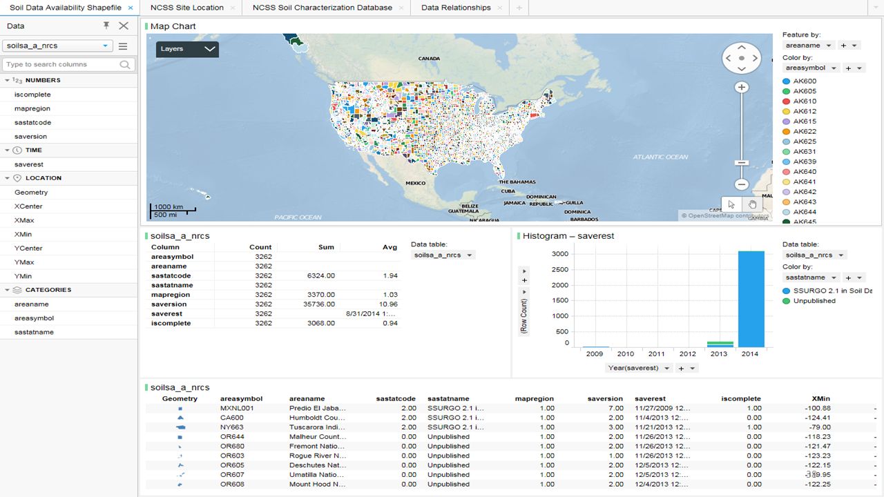
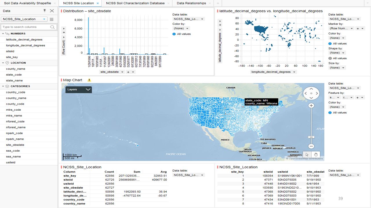
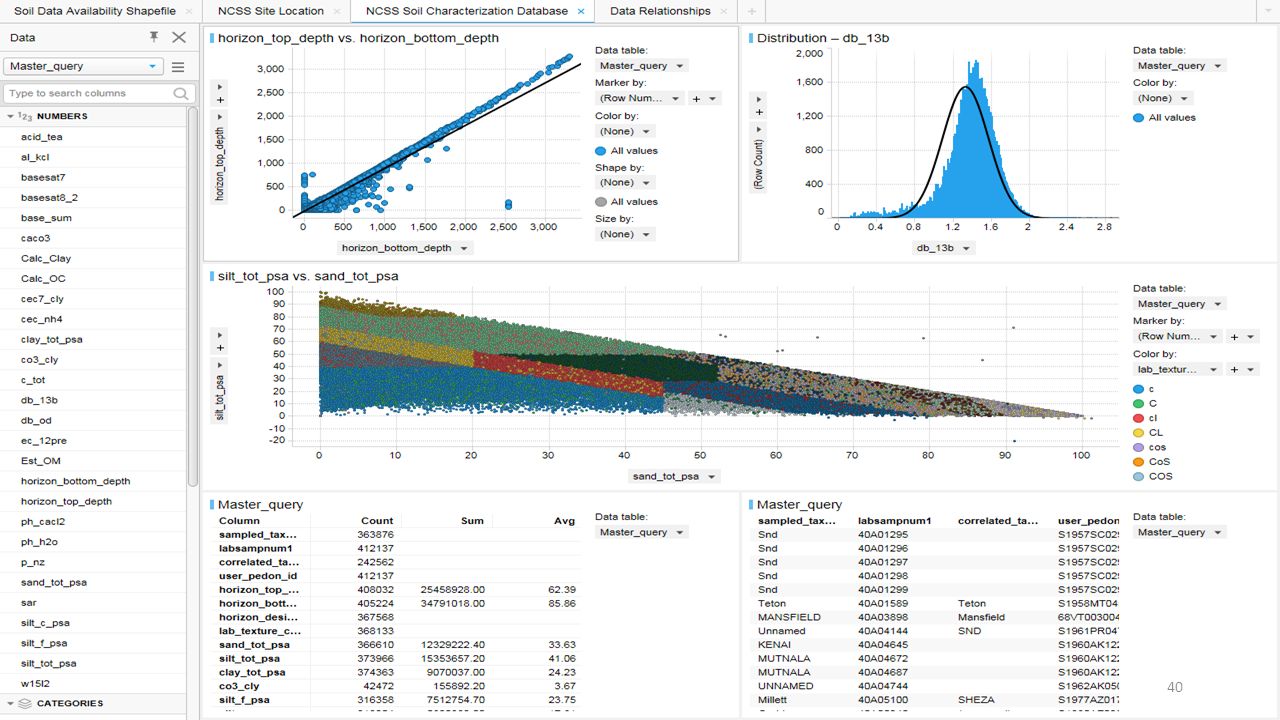
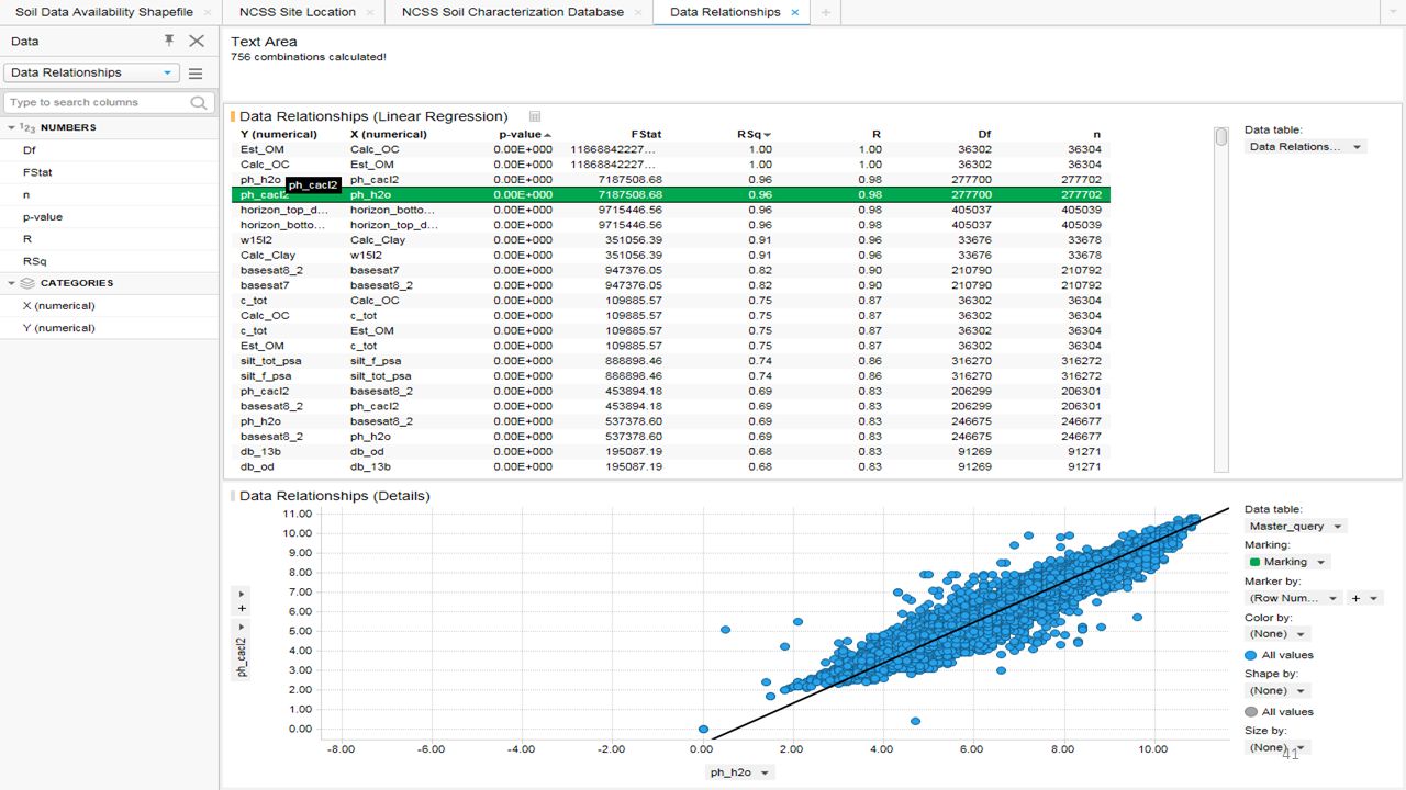
Mindtouch Spreadsheet UNL Cropwatch: Software Tools Powerpoint Presentations Tutorials International Plant Nutrition Institute: AgriStats An International Journal on Advances in Precision Agriculture Data Science Data Publication USDA Soils Data Sets: Natural Resources Conservation Service: Soils FY2015 gSSURGO Database Release Soil Survey Sidebar Hierarchy Digital Soil Geographic Databases (GIS-ready) Weeks 4 and 5 Soil File Inventory for Visualization and Modeling in Spotfire: NCSS_Soil_Characterization_Database SoilDataAvailabilityShapefile Otoe County, Nebraska: PDF, GIF, and PNG Master_query and NCSS_Site_Location wss_SSA_NE131_soildb_NE_2003_[ ] wss_gsmsoil_NE_[ ] nrcs142p2_ and PDF Image Map NCSSSoilSurvey FarmData-Spotfire LandCover XLS?
 Weeks 4 and 5 Soil File Inventory for Visualization and Modeling in Spotfire: NCSS_Soil_Characterization_Database. SoilDataAvailabilityShapefile. Otoe County, Nebraska: PDF, GIF, and PNG. Master_query and NCSS_Site_Location. wss_SSA_NE131_soildb_NE_2003_[ ] wss_gsmsoil_NE_[ ] nrcs142p2_ and PDF Image Map. NCSSSoilSurvey. FarmData-Spotfire LandCover XLS")
3
Semantic Community Data Science Big Data Science for Precision Farming Business Week 5 Evaluation

4
FarmData.xlsx

5
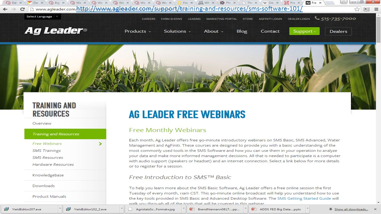
UNL Cropwatch Software Tools:
Yield Editor Get Newest Version: Yield Editor See next slide Yield Check FOViewer (MapShots) Powerpoint Presentations: These are PDFs and 2013 Yield Data Cleaning: Why it's Important Yield Data Collection BMPs: Minimizing errors and downtime Yield Monitoring Systems: Understanding How Yield is Estimated Tutorials: See Ag Leader's industry-leading SMS Software and Free Download Trial and Webinars Comparison Analysis Tutorial Creating Grid or Contour Maps Data into SMS Tutorial Bringing Yield Data Importing Clean Data Tutorial Bringing Yield Data Back Using Yield Editor Tutorial
 Powerpoint Presentations: These are PDFs and Yield Data Cleaning: Why it s Important. Yield Data Collection BMPs: Minimizing errors and downtime. Yield Monitoring Systems: Understanding How Yield is Estimated. Tutorials: See Ag Leader s industry-leading SMS Software and Free Download Trial and Webinars. Comparison Analysis Tutorial. Creating Grid or Contour Maps. Data into SMS Tutorial Bringing Yield Data. Importing Clean Data Tutorial Bringing Yield Data Back. Using Yield Editor Tutorial.")
6
Yield Editor Get Newest Version: Yield Editor 2.0.7:
Yield Editor v is a tool which allows the user to select, apply and analyze a variety of automated filters and editing techniques used to process and clean yield data. The software imports either AgLeader advanced or Greenstar text file formats, and exports data in a delimited ASCII format. tware/software.htm?modecode= Yield Editor 2.0

7
Yield Monitoring Systems: Understanding How Yield is Estimated

9
https://dealer.agleader.com/kbp/
Free Download Trial

10
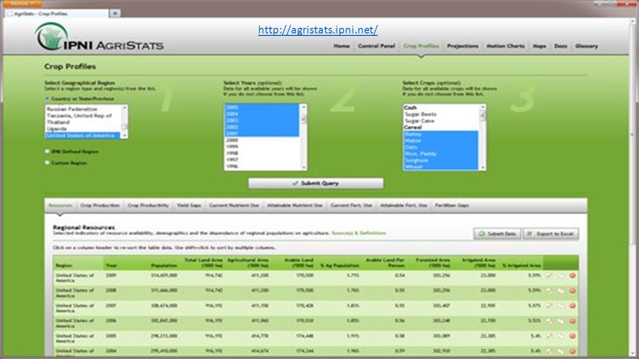
International Plant Nutrition Institute
AgriStats (APPLIED FOR ACCESS) A unique web-based information system that is available to all IPNI Members and their Staff. The system is designed to collect yield and associated fertilizer use data from regions in which we conduct our Programs. Please consult the AgriStats Manual. A glossary section is available within AgriStats for help on the available functions, the current dataset, and the terms and definitions used to describe the data. Access to AgriStats, its data tables, and reports represents a license to use these materials as a resource and does not grant permission for indiscriminate copying or unauthorized use. Although IPNI asks to be cited as a source when AgriStats data are used, the Institute cannot endorse external analyses resulting from its use or guarantee future nutrient use based on AgriStat predictions. An International Journal on Advances in Precision Agriculture: Index in Spreadsheet for Search and Identify Free Downloads Data Science Data Publication: NuGIS – See Data Science for USDA Big Data Other Selected from Free Downloads Above (IN PROCESS)
 A unique web-based information system that is available to all IPNI Members and their Staff. The system is designed to collect yield and associated fertilizer use data from regions in which we conduct our Programs. Please consult the AgriStats Manual. A glossary section is available within AgriStats for help on the available functions, the current dataset, and the terms and definitions used to describe the data. Access to AgriStats, its data tables, and reports represents a license to use these materials as a resource and does not grant permission for indiscriminate copying or unauthorized use. Although IPNI asks to be cited as a source when AgriStats data are used, the Institute cannot endorse external analyses resulting from its use or guarantee future nutrient use based on AgriStat predictions. An International Journal on Advances in Precision Agriculture: Index in Spreadsheet for Search and Identify Free Downloads. Data Science Data Publication: NuGIS – See Data Science for USDA Big Data. Other Selected from Free Downloads Above (IN PROCESS)")
12
Glossary Section

13
FarmData.xlsx An International Journal on Advances in Precision Agriculture: Index in Spreadsheet for Search and Identify Free Downloads

14
Data Science Data Publication

15
Web Player 10 MB

16
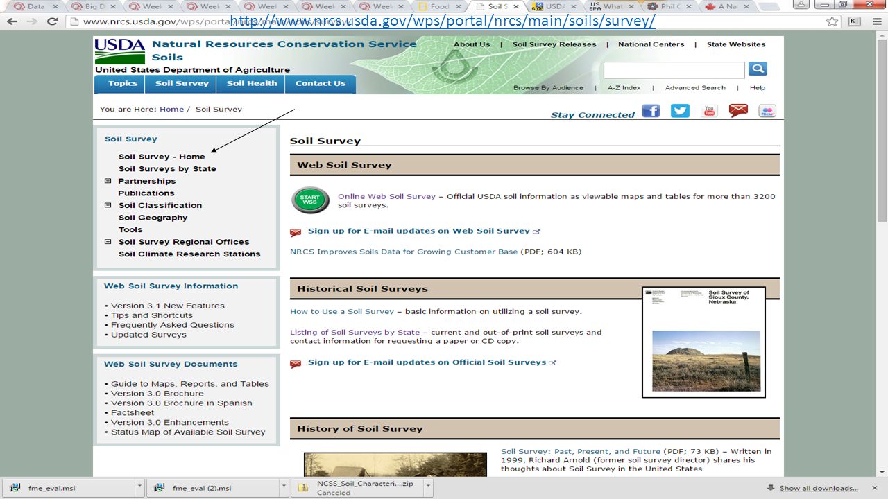
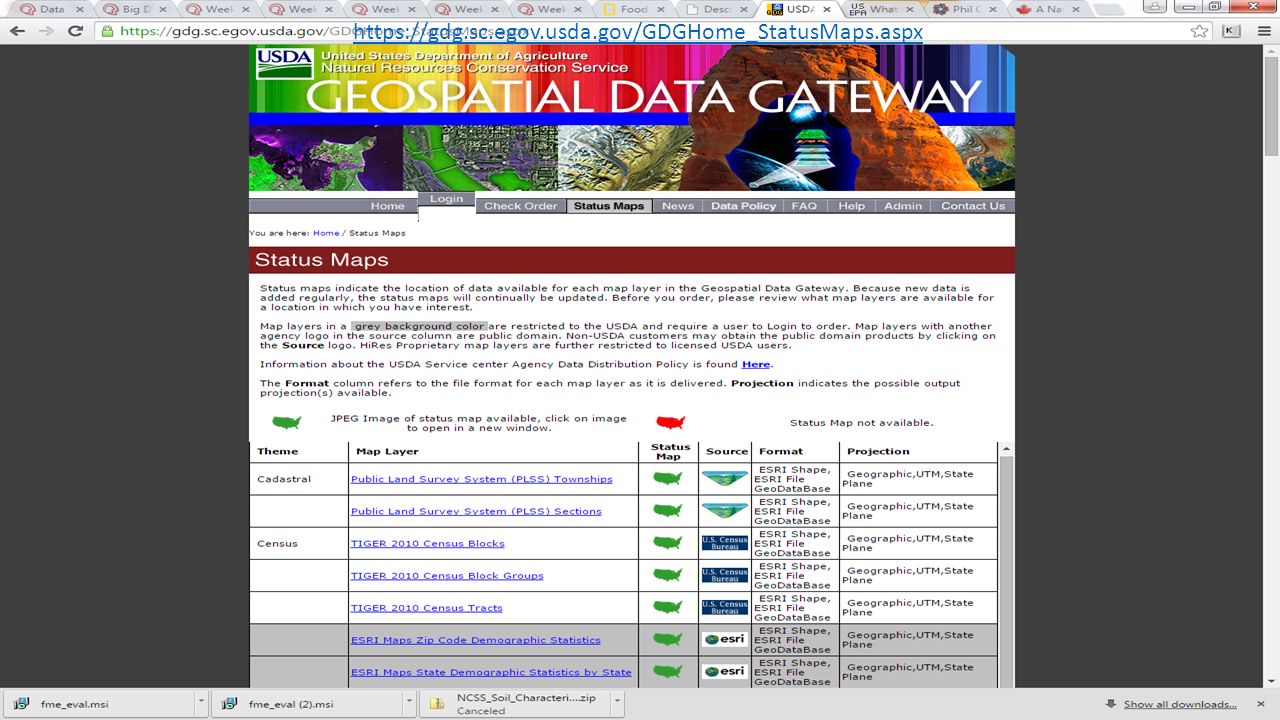
USDA Soils Data Sets Natural Resources Conservation Service: Soils
FY2015 gSSURGO Database Release Soil Survey Sidebar Hierarchy: Home By State Soil Classification Soil Geography: Soil Geographic Data Sets Digital Soil Geographic Databases (GIS-ready) Land Resource Regions (LRR) and Major Land Resource Areas (MLRA) Common Resource Areas (CRA) U.S. General Soil Map (STATSGO2) Soil Survey Geographic (SSURGO) Database Gridded Soil Survey Geographic (gSSURGO) Database (See Previous Slides) National Cooperative Soil Survey Soil Characterization Database (Pedons)
 Land Resource Regions (LRR) and Major Land Resource Areas (MLRA) Common Resource Areas (CRA) U.S. General Soil Map (STATSGO2) Soil Survey Geographic (SSURGO) Database. Gridded Soil Survey Geographic (gSSURGO) Database (See Previous Slides) National Cooperative Soil Survey Soil Characterization Database (Pedons)")
17
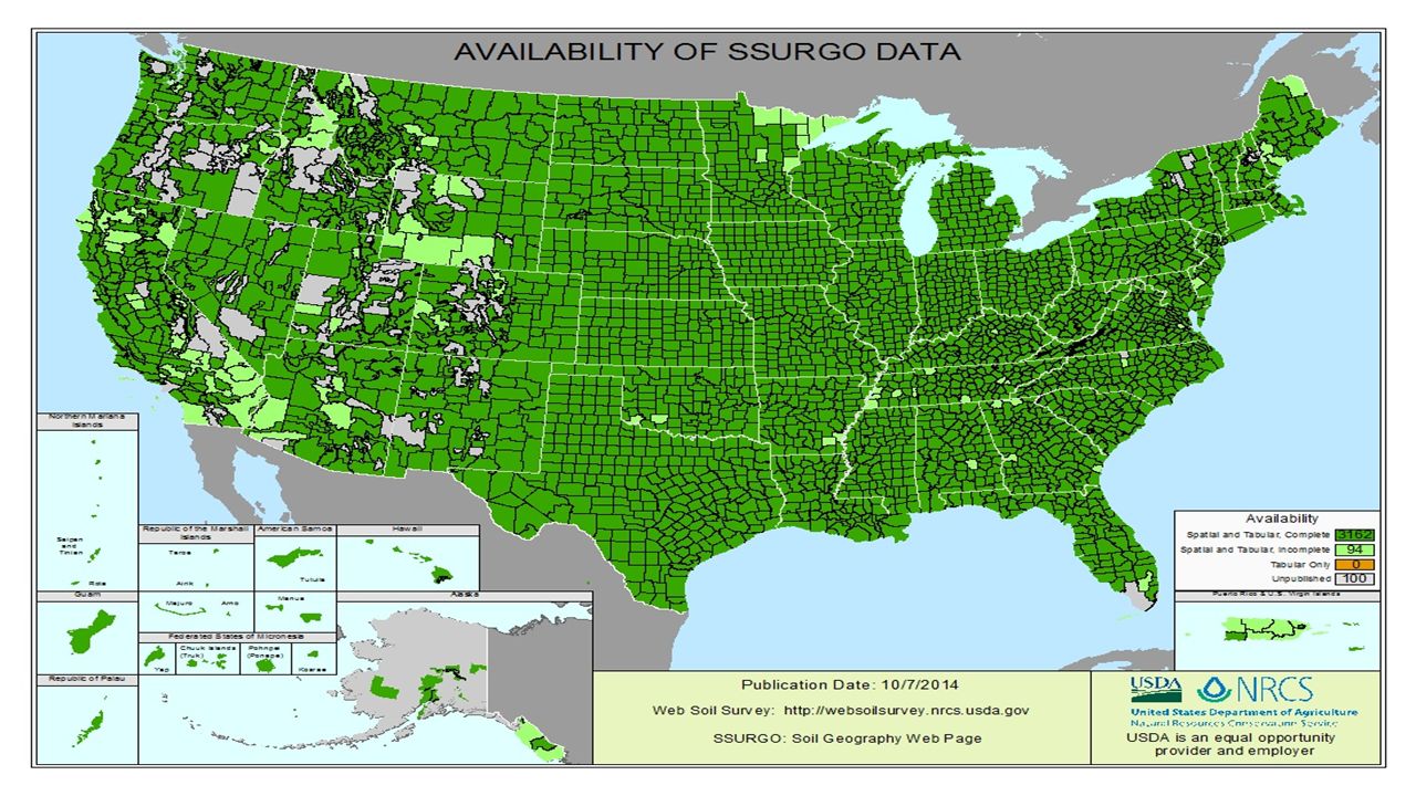
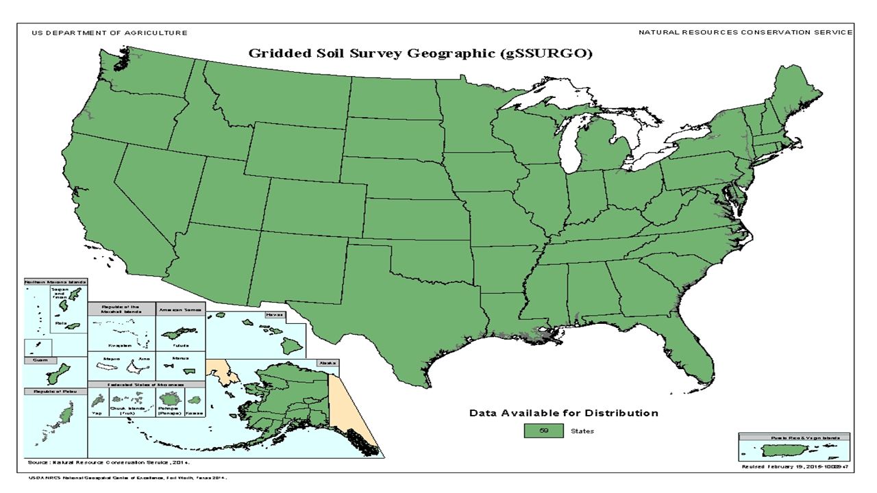
FY2015 gSSURGO Database ReleaseThe FY2015 Gridded Soil Survey Geographic (gSSURGO) Database was released on February 23, These data are derived from a December 1, 2014, snapshot of the Soil Data Mart database. These new data are available in both state-wide tiles and the Conterminous U.S. (CONUS).
 Database was released on February 23, These data are derived from a December 1, 2014, snapshot of the Soil Data Mart database. These new data are available in both state-wide tiles and the Conterminous U.S. (CONUS).")
18
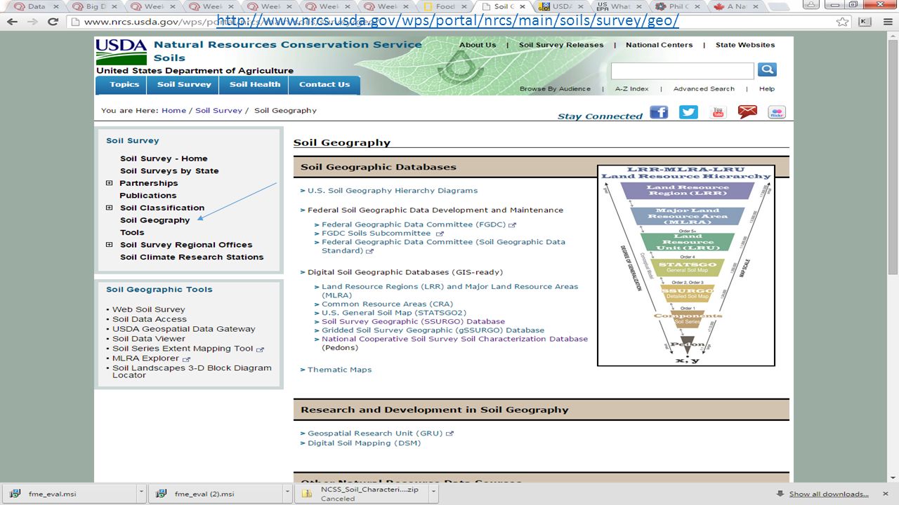
http://www. nrcs. usda. gov/wps/portal/nrcs/detail/soils/survey/geo/

19
Description of Gridded Soil Survey Geographic (gSSURGO) Database
Gridded SSURGO (gSSURGO) is similar to the standard USDA-NRCS Soil Survey Geographic (SSURGO) Database product but in the format of an Environmental Systems Research Institute, Inc. (ESRI®) file geodatabase. A file geodatabase has the capacity to store much more data and thus greater spatial extents than the traditional SSURGO product. This makes it possible to offer these data in statewide or even Conterminous United States (CONUS) tiles. gSSURGO contains all of the original soil attribute tables in SSURGO. All spatial data are stored within the geodatabase instead of externally as separate shapefiles. Both SSURGO and gSSURGO are considered products of the National Cooperative Soil Survey (NCSS) partnership. The gridded SSURGO (gSSURGO) dataset was created for use in national, regional, and statewide resource planning and analysis of soils data. The raster map layer data can be readily combined with other national, regional, and local raster layers, including the National Land Cover Database (NLCD), the National Agricultural Statistics Service (NASS) Crop Data Layer (CDL), and the National Elevation Dataset (NED).
 is similar to the standard USDA-NRCS Soil Survey Geographic (SSURGO) Database product but in the format of an Environmental Systems Research Institute, Inc. (ESRI®) file geodatabase. A file geodatabase has the capacity to store much more data and thus greater spatial extents than the traditional SSURGO product. This makes it possible to offer these data in statewide or even Conterminous United States (CONUS) tiles. gSSURGO contains all of the original soil attribute tables in SSURGO. All spatial data are stored within the geodatabase instead of externally as separate shapefiles. Both SSURGO and gSSURGO are considered products of the National Cooperative Soil Survey (NCSS) partnership. The gridded SSURGO (gSSURGO) dataset was created for use in national, regional, and statewide resource planning and analysis of soils data. The raster map layer data can be readily combined with other national, regional, and local raster layers, including the National Land Cover Database (NLCD), the National Agricultural Statistics Service (NASS) Crop Data Layer (CDL), and the National Elevation Dataset (NED).")
21
My Note: This is where I Got: Otoe County: Manuscript (PDF; 19.7 MB ) Date: Current Archived PDF On-line: No Web Soil Survey (generated from official soil data): Yes
 Date: Current. Archived PDF On-line: No. Web Soil Survey (generated from official soil data): Yes.")
22
My Note: Lots of valuable information here. I am focused on the actual geographic data sets.

24
Digital Soil Geographic Databases (GIS-ready)
Land Resource Regions (LRR) and Major Land Resource Areas (MLRA): Common Resource Areas (CRA): U.S. General Soil Map (STATSGO2): Soil Survey Geographic (SSURGO) Database: Gridded Soil Survey Geographic (gSSURGO) Database (See Previous Slides): National Cooperative Soil Survey Soil Characterization Database (Pedons):
 and Major Land Resource Areas (MLRA): cid=nrcs142p2_ Common Resource Areas (CRA): cid=nrcs142p2_ U.S. General Soil Map (STATSGO2): cid=nrcs142p2_ Soil Survey Geographic (SSURGO) Database: cid=nrcs142p2_ Gridded Soil Survey Geographic (gSSURGO) Database (See Previous Slides): cid=nrcs142p2_ National Cooperative Soil Survey Soil Characterization Database (Pedons):")
25
http://www. nrcs. usda. gov/wps/portal/nrcs/detail/soils/survey/geo/

26
http://www. nrcs. usda. gov/wps/portal/nrcs/detail/soils/survey/geo/
My Note: Only By State? CRA Geographic Database version 1.2 GIS data products are available for downloading. Go to Geospatial Data Gateway and click on Order by State. Select the State, then find Common Resource Areas by State under the Soils section.

27
http://www. nrcs. usda. gov/wps/portal/nrcs/detail/soils/survey/geo/
My Note: See Next Slide

28
http://websoilsurvey. sc. egov. usda
My Note: Did Not Download

29
http://www. nrcs. usda. gov/wps/portal/nrcs/detail/soils/survey/geo/
My Note: See Next Slide

30
My Note: Pick All States But Only Got All 3262 Counties, Etc. Downloaded Nebraska

33
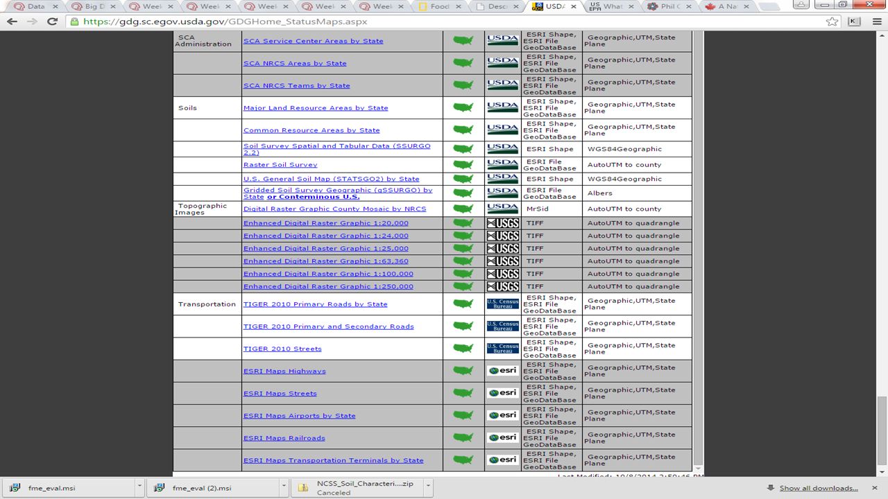
Map Layer Status Map/Spotfire Source Format Projection Major Land Resource Areas by State Link Yes USDA ESRI Shape, ESRI File GeoDataBase Geographic,UTM,State Plane Common Resource Areas by State Link State Only? Soil Survey Spatial and Tabular Data (SSURGO 2.2) ESRI Shape WGS84Geographic Raster Soil Survey Link GDB-to-SHP, Not Yet ESRI File GeoDataBase AutoUTM to county U.S. General Soil Map (STATSGO2) by State Link Nebraska, Yes Gridded Soil Survey Geographic (gSSURGO) by State or Conterminous U.S. Link GDB-to-SHP, Yes Albers My Note: These Links Do Not Go To Data Download
 ESRI Shape. WGS84Geographic. Raster Soil Survey. Link GDB-to-SHP, Not Yet. ESRI File GeoDataBase. AutoUTM to county. U.S. General Soil Map (STATSGO2) by State. Link Nebraska, Yes. Gridded Soil Survey Geographic (gSSURGO) by State or Conterminous U.S. Link GDB-to-SHP, Yes. Albers. My Note: These Links Do Not Go To Data Download.")
36
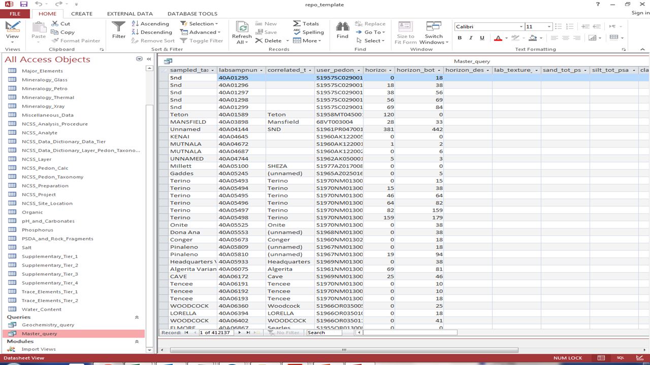
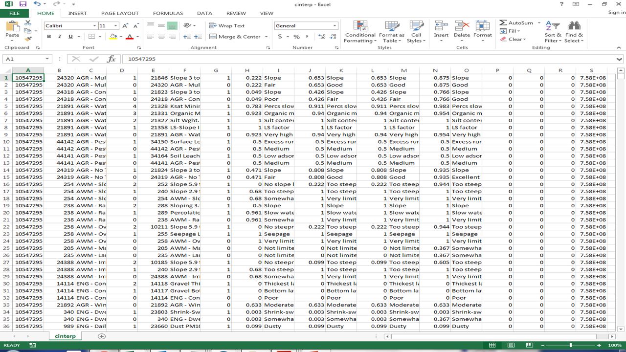
National Cooperative Soil Survey (NCSS) Soil Characterization Database
Pedons: The smallest unit or volume of soil that contains all the soil horizons of a particular soil type. It usually has a surface area of approximately 1 sq m (10.76 sq ft) and extends from the ground surface down to bedrock. A Microsoft Access database that contains the most commonly requested data from the National Cooperative Soil Survey Laboratories is available. The database includes data from the Kellogg Soil Survey Laboratory and cooperating universities. In addition to commonly requested data, the Access database includes metadata tables that describe the column headings of the laboratory data tables. In the Access database, the results of similar analyses have been combined and are presented in common columns. Users that wish to obtain the original data, which is separated by method codes, can download the data from the Basic or Advanced query pages. Click on the following link to download the Access database: NCSS Microsoft Access Soil Characterization Database (Zip file; 1.1 MB).
 and extends from the ground surface down to bedrock. A Microsoft Access database that contains the most commonly requested data from the National Cooperative Soil Survey Laboratories is available. The database includes data from the Kellogg Soil Survey Laboratory and cooperating universities. In addition to commonly requested data, the Access database includes metadata tables that describe the column headings of the laboratory data tables. In the Access database, the results of similar analyses have been combined and are presented in common columns. Users that wish to obtain the original data, which is separated by method codes, can download the data from the Basic or Advanced query pages. Click on the following link to download the Access database: NCSS Microsoft Access Soil Characterization Database (Zip file; 1.1 MB).")
37
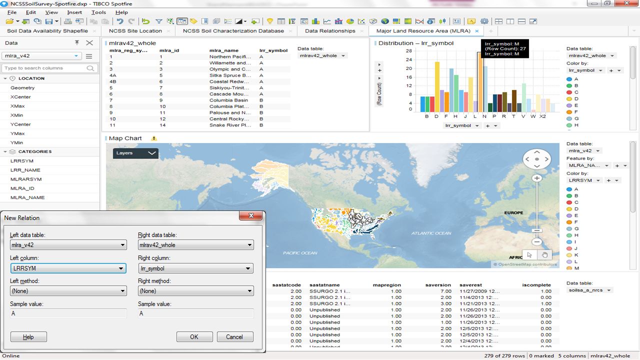
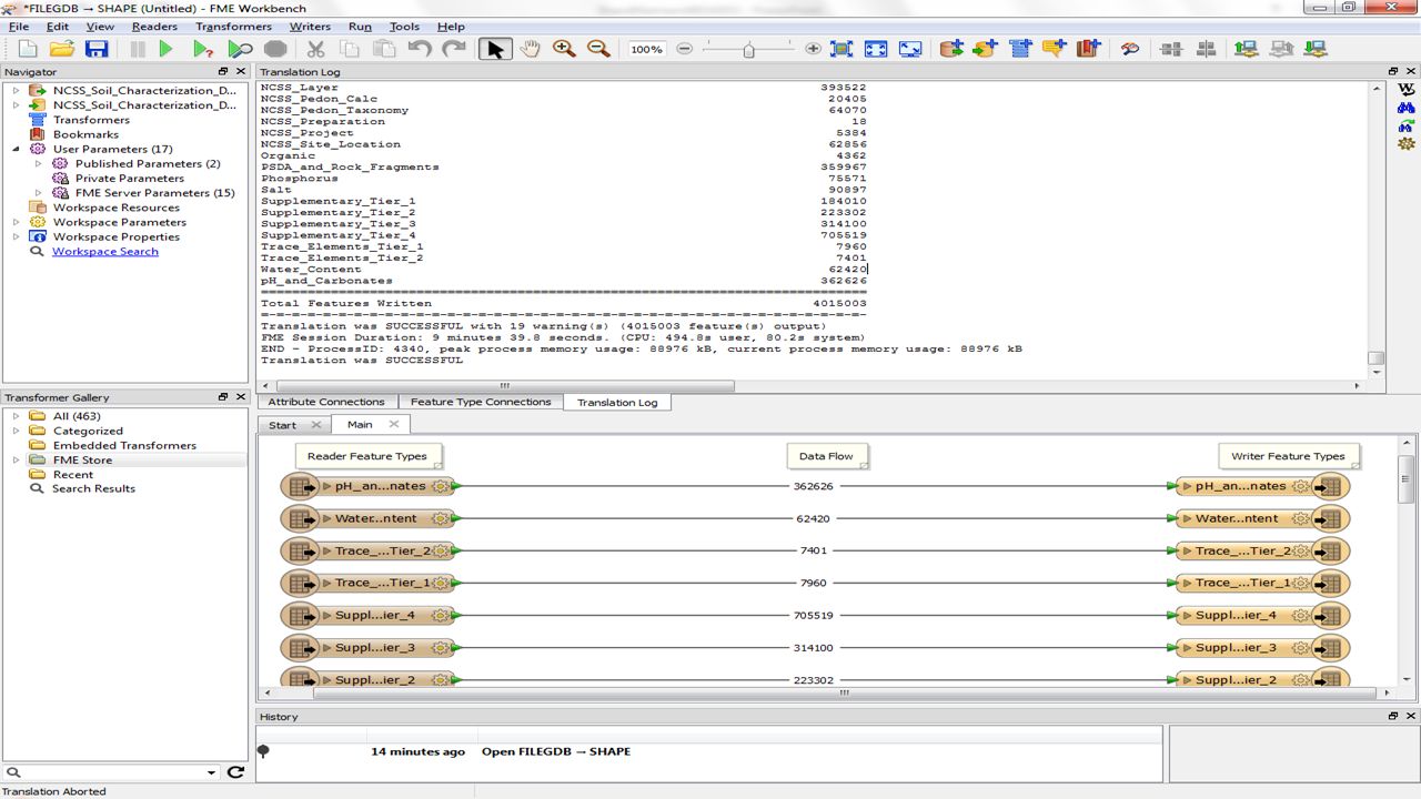
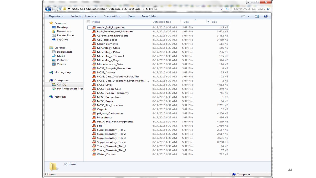
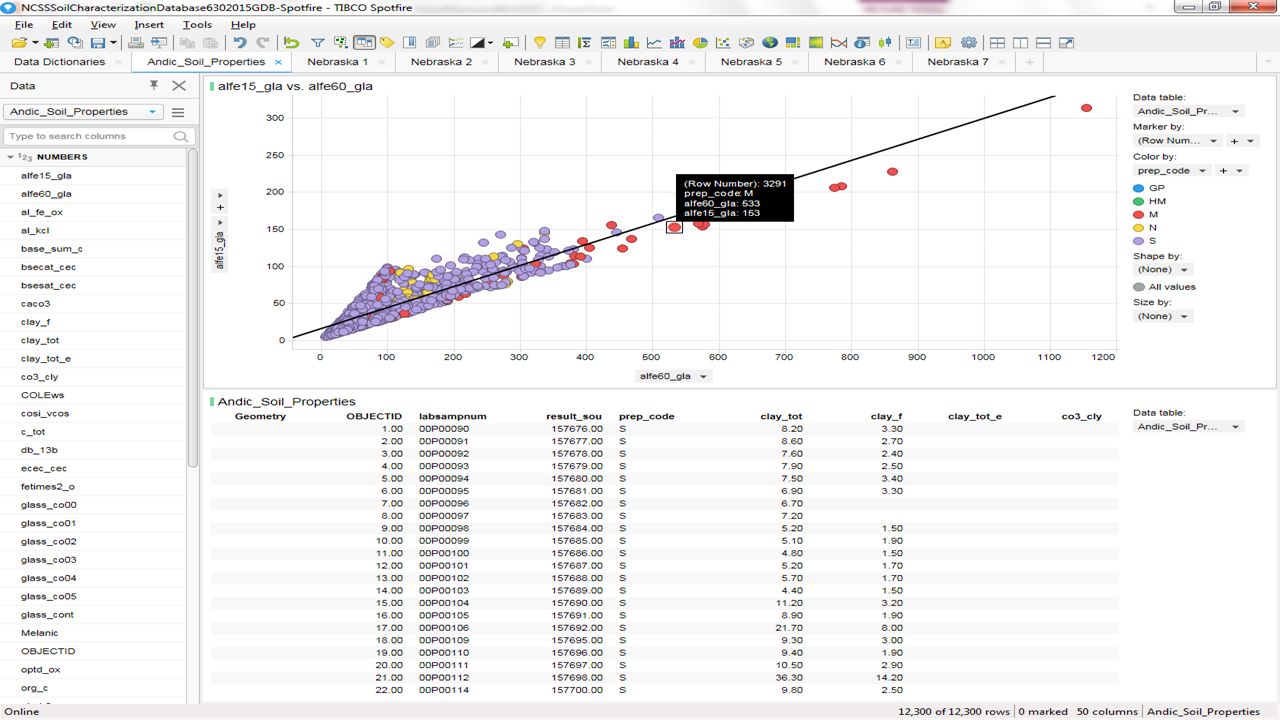
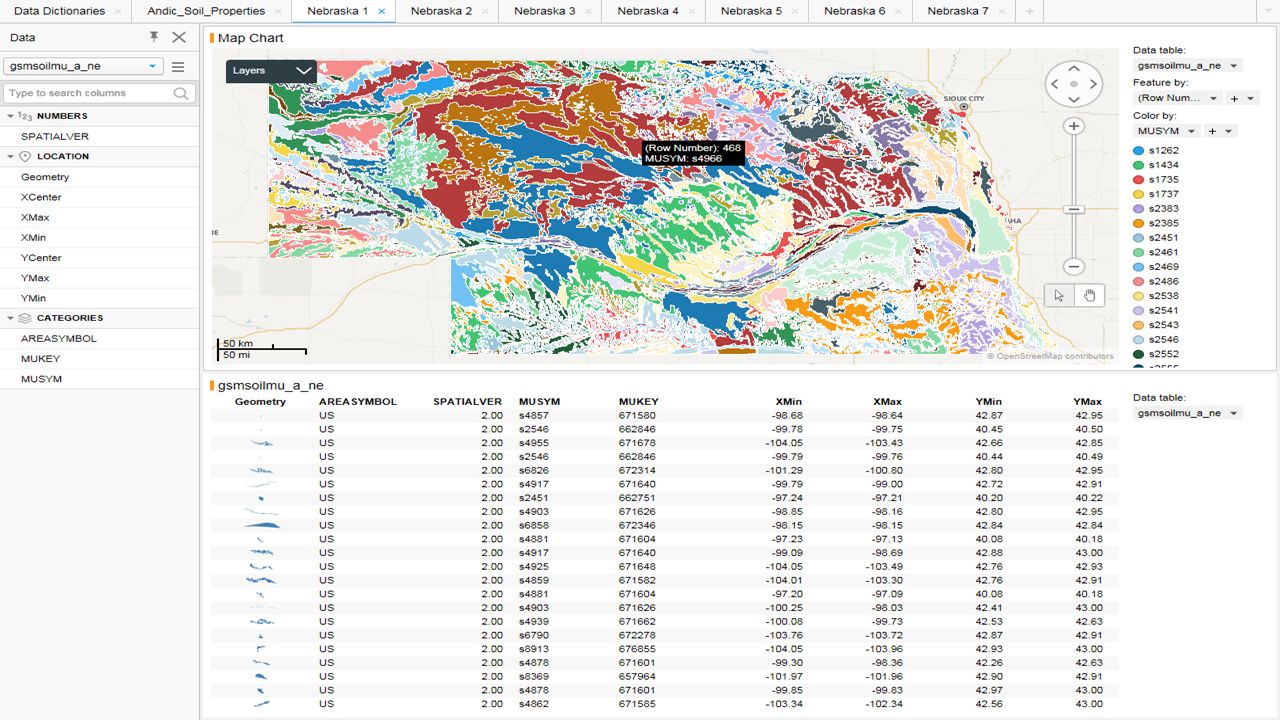
Weeks 4 and 5 Soil File Inventory for Spotfire
NCSS_Soil_Characterization_Database: GDB and Access (NCSSSoilCharacterizationDatabase GDB-Spotfire) SoilDataAvailabilityShapefile: Shape (NCSSSoilSurvey-Spotfire) Otoe County, Nebraska: PDF, GIF, and PNG (FarmData-Spotfire) Master_query 72 MB Excel and NCSS_Site_Location 7 MB Excel (NCSSSoilSurvey- Spotfire) and (FarmData-Spotfire) Week 5: wss_SSA_NE131_soildb_NE_2003_[ ] 19 MB Shape and 12 MB Access (NCSSSoilCharacterizationDatabase GDB-Spotfire) wss_gsmsoil_NE_[ ] 8 MB Shape and 11 MB Access (NCSSSoilCharacterizationDatabase GDB-Spotfire) nrcs142p2_ MB Shape and Excel and PDF Image Map (NCSSSoilSurvey- Spotfire) and (FarmData-Spotfire)
 SoilDataAvailabilityShapefile: Shape (NCSSSoilSurvey-Spotfire) Otoe County, Nebraska: PDF, GIF, and PNG (FarmData-Spotfire) Master_query 72 MB Excel and NCSS_Site_Location 7 MB Excel (NCSSSoilSurvey- Spotfire) and (FarmData-Spotfire) Week 5: wss_SSA_NE131_soildb_NE_2003_[ ] 19 MB Shape and 12 MB Access (NCSSSoilCharacterizationDatabase GDB-Spotfire) wss_gsmsoil_NE_[ ] 8 MB Shape and 11 MB Access (NCSSSoilCharacterizationDatabase GDB-Spotfire) nrcs142p2_ MB Shape and Excel and PDF Image Map (NCSSSoilSurvey- Spotfire) and (FarmData-Spotfire)")
Similar presentations


 software services with new and existing clients. Presentation.>")


