Download presentation
Presentation is loading. Please wait.

1
Oregon DOT Geometronics Unit Update Ken Bays Lead Geodetic Surveyor ODOT Geometronics Unit 16 September 2008 CGSIC States & Localities Savannah, Georgia

2
Mission: ODOT Geometronics Unit Preserve and enhance geodetic control in the State of Oregon Preserve and enhance geodetic control in the State of Oregon

3
Overview Gravity Campaign in Oregon Gravity Campaign in Oregon NGS National Gravity Survey PlanNGS National Gravity Survey Plan Oregon Gravity Surveys 2007Oregon Gravity Surveys 2007 Precise Digital Leveling in Oregon Precise Digital Leveling in Oregon Oregon Real-time GPS Network Update Oregon Real-time GPS Network Update Outreach/Education Outreach/Education

4
Gravity NGS National Gravity Survey Plan NGS National Gravity Survey Plan 2007 Oregon Gravity Survey 2007 Oregon Gravity Survey

5
Sir Isaac Newton (1643-1727)
")
6
NGS National Gravity Survey Plan The GRAV-D Project: Gravity for the Redefinition of the American Vertical Datum Accurate gravity data is the foundation for the Federal governments determination of heights

7
Why a Gravity Survey is Needed GPS Ellipsoid heights cannot be used to determine where water will flow, and therefore are not used in topographic/floodplain mapping. Orthometric heights are related to water flow and more useful. NGS National Gravity Survey Plan

8
Geoid - Ellipsoid Relationship HEIGHT ABOVE ELLIPSOID (HAE) OCEAN GEOID SURFACE (MEAN SEA LEVEL) ELLIPSOID GEOID SEPARATION (GEOID HEIGHT) EARTHS SURFACE MEAN SEA LEVEL ELEVATION (ORTHOMETRIC HEIGHT)
 OCEAN GEOID SURFACE (MEAN SEA LEVEL) ELLIPSOID GEOID SEPARATION (GEOID HEIGHT) EARTHS SURFACE MEAN SEA LEVEL ELEVATION (ORTHOMETRIC HEIGHT)")
9
Why a Gravity Survey is Needed In order to transform from ellipsoid heights to orthometric heights, a model of the geoid must be computed. Geoid modeling can only be done with measurements of the acceleration of gravity near the Earths surface. NGS National Gravity Survey Plan

10
Grav-D Project Summary I. High resolution snapshot to repair and improve existing gravity holdings a one-time survey with dense spatial coverage but short time frame (7-10 years) Rely heavily on airborne gravity II. II. Low resolution movie to track the temporal changes to the gravity field on a broad scale a re-occurring survey with very coarse spatial coverage and a long time span. III. Terrestrial Partnership Surveys to measure and/or track very localized gravity values of particular importance to the fine-scale local determination of heights
 Rely heavily on airborne gravity II. II. Low resolution movie to track the temporal changes to the gravity field on a broad scale a re-occurring survey with very coarse spatial coverage and a long time span. III. Terrestrial Partnership Surveys to measure and/or track very localized gravity values of particular importance to the fine-scale local determination of heights.")
11
Campaign III: Terrestrial Partnership Surveys A boots-on-the-ground re-check of each place where new airborne gravity surveys disagree with existing terrestrial gravity data In general such surveys are expected to rely heavily upon the partnerships NGS has formed, and will form, through a National Height Modernization program NGS will engage local partners in the surveys, including loaning equipment and providing training in the use of the equipment, and submittal of processed data to NGS. Potential for localized geoid slopes to be directly determined from field surveys of co-located (space and time) leveling and GPS.
 leveling and GPS..")
12
From Astoria to Crater Lake….

13
….A Story of Bouys & Gals

14
Unit of Gravity Measurements Gal = 1 cm/sec2 Gal = 1 cm/sec2 Named in honor of Galileo Galilei Named in honor of Galileo Galilei

15
Average Gravity Force on Earths Surface 32 ft/sec 2 is average force on Earths surface 32 ft/sec 2 is average force on Earths surface = 9.8 meters/sec 2 = 9.8 meters/sec 2 = 980 centimeters/sec 2 (or 980 Gals) = 980 centimeters/sec 2 (or 980 Gals) = 980,000 milliGals (mGals) = 980,000 milliGals (mGals) Typically, gravity observations are recorded in milliGals, a milliGal is about 1 millionth of the acceleration of gravity at the earth's surface. Typically, gravity observations are recorded in milliGals, a milliGal is about 1 millionth of the acceleration of gravity at the earth's surface.

18
The Process Absolute gravity measured by Dan Winester, NGS Absolute gravity measured by Dan Winester, NGS Transfer absolute gravity reading to ground w/relative meter Transfer absolute gravity reading to ground w/relative meter Transfer absolute ground to Excenter Transfer absolute ground to Excenter Search for Old Gravity Stations Search for Old Gravity Stations Run relative loops from Excenter to previously observed stations (double run) Run relative loops from Excenter to previously observed stations (double run)
 Run relative loops from Excenter to previously observed stations (double run)")
19
Absolute Sites

20
Absolute Gravimeter

21
Basically an accelerometer Basically an accelerometer The descent of a free- falling object inside of the absolute gravimeter is monitored very accurately with an accurately timed laser interferometer The descent of a free- falling object inside of the absolute gravimeter is monitored very accurately with an accurately timed laser interferometer Accuracy: 2 microGal (observed agreement between FG5 instruments) Accuracy: 2 microGal (observed agreement between FG5 instruments)
 Accuracy: 2 microGal (observed agreement between FG5 instruments)")
22
Transferring Gravity to the Ground

23
Relative Gravimeter

24
A spring used to counteract the force of gravity pulling on an object. A spring used to counteract the force of gravity pulling on an object. The change in length of the spring may be calibrated to the force required to balance the gravitational pull on the object. The change in length of the spring may be calibrated to the force required to balance the gravitational pull on the object.

25
Excenters

26
Transferring Absolute to Excenter

27
Relative Sites

28
2007 Planning

29
Searching for Gravity Stations Very Old Poorly Written Descriptions Very Old Poorly Written Descriptions Many were not Monumented Many were not Monumented 100+ Stations to Measure 100+ Stations to Measure Lots of Driving and Long Days Lots of Driving and Long Days Three Months to Complete the State Three Months to Complete the State

31
Excenter to Existing Gravity Stations around the state

32
ODOT put us up in some of the best places

33
Precise Leveling in Oregon Preservation and replacement of Benchmarks in Oregon Preservation and replacement of Benchmarks in Oregon Run levels to stations of the Oregon Real- time GPS Network as part of Height Modernization program. Run levels to stations of the Oregon Real- time GPS Network as part of Height Modernization program. Potential for localized geoid slopes to be directly determined from field surveys of co-located (space and time) leveling and GPS. NGS National Gravity Survey Plan
 leveling and GPS. NGS National Gravity Survey Plan.")
34
Precise Leveling Acquired all equipment Acquired all equipment First order Leica DNA-03 levelFirst order Leica DNA-03 level Invar rodsInvar rods Invar 60 cm strip (for vertical Bms)Invar 60 cm strip (for vertical Bms) ThermistersThermisters TurtlesTurtles Turning PinsTurning Pins Acquired Training Acquired Training NGS Precise Leveling WorkshopNGS Precise Leveling Workshop Curt Smith, NGS State Advisor tutorial provided on-project trainingCurt Smith, NGS State Advisor tutorial provided on-project training
Invar 60 cm strip (for vertical Bms) ThermistersThermisters TurtlesTurtles Turning PinsTurning Pins Acquired Training Acquired Training NGS Precise Leveling WorkshopNGS Precise Leveling Workshop Curt Smith, NGS State Advisor tutorial provided on-project trainingCurt Smith, NGS State Advisor tutorial provided on-project training")
35
Stanford Linear Accelerator Center Vertical Comparator for the Calibration of Leveling Equipment A fully automated vertical comparator for the calibration of digital levels and invar staffs A fully automated vertical comparator for the calibration of digital levels and invar staffs Developed by the Metrology Department in cooperation with the Institute of Engineering Geodesy and Measurement Systems at the Graz University of Technology. Developed by the Metrology Department in cooperation with the Institute of Engineering Geodesy and Measurement Systems at the Graz University of Technology. The vertical comparator was built in 2003 in the SLAC Metrology laboratory The vertical comparator was built in 2003 in the SLAC Metrology laboratory

36
Oregon Real-time GPS Network www.TheORGN.net

37
Administrator Oregon Department of Transportation Oregon Department of Transportation Geometronics UnitGeometronics Unit Program Manager: Ron Singh Program Manager: Ron Singh Technical Manager: Ken Bays Technical Manager: Ken Bays ORGN Support:Randy Oberg ORGN Support:Randy Oberg

38
Administrator Responsibilities Network quality control Network quality control Network software operation Network software operation Network software maintenance and upgrades Network software maintenance and upgrades User support User support

39
Major Cooperators & Support NGS NGS UNAVCO Plate Boundary Observatory UNAVCO Plate Boundary Observatory Washington State Reference Network Washington State Reference Network Exchange of raw GPS data streams across the Columbia River.Exchange of raw GPS data streams across the Columbia River. California and Idaho as their networks develops California and Idaho as their networks develops

40
Partners Partners will provide sites, GPS equipment, and other major infrastructure to the network. Partners will provide sites, GPS equipment, and other major infrastructure to the network. Government agenciesGovernment agencies Inter-Governmental Agreements Inter-Governmental Agreements Private entitiesPrivate entities Public-Private Partnerships Public-Private Partnerships

41
Some, but not all, of our Interested Partners OBEC Consulting Engineers Polk County Deschutes County EWEB City of Beaverton City of Newberg Washington County City of Springfield Curry County Washington DOT Washington DOT City of Bend Linn County David Evans & Associates Lincoln County Multnomah County Oregon Division of Aviation Yamhill County City of Salem Clackamas County Marion County OR Jackson County Lane County Tualatin Valley Water District Port of Portland Oregon State University City of Wilsonville Clatsop County Douglas County Portland Water Bureau Benton County Oregon Parks and Recreation Department

42
Subscribers Anyone who is not a partner and wants access to RTK correctors data from the ORGN. Anyone who is not a partner and wants access to RTK correctors data from the ORGN. Must have rover account set up Must have rover account set up No direct fee at this time No direct fee at this time Online rover account application at www.TheORGN.netOnline rover account application at www.TheORGN.net May have minimal fee in future to cover operation, maintenance, and upgrades, but not to cover the build of the infrastructure of the network. May have minimal fee in future to cover operation, maintenance, and upgrades, but not to cover the build of the infrastructure of the network.

43
September 2008

44
December 2008

45
July 2009

46
Can I Trust the ORGN for Accurate GPS Positions? Installation Pre-testing of PositionsPre-testing of Positions Extreme CareExtreme Care Sturdy Antenna MountsSturdy Antenna Mounts Carefully Calculated Positions Carefully Calculated Positions Constant Monitoring of Antenna Positions Constant Monitoring of Antenna Positions Precise Emphemeris used for Correctors Precise Emphemeris used for Correctors

47
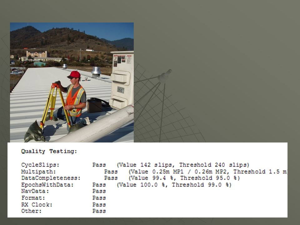
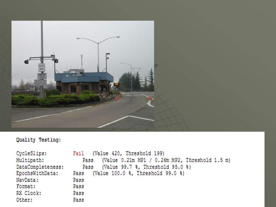
Site Criteria Standards 60 Km Station Spacing 60 Km Station Spacing Satellite visibility: clear view of sky Satellite visibility: clear view of sky No electromagnetic interference No electromagnetic interference Pre-installation data quality sets: 3 days of GPS data Pre-installation data quality sets: 3 days of GPS data Continuous power w/ backup Continuous power w/ backup Internet connectivity Internet connectivity

50
Solid Antenna Mounts

51
ORGN Coordinates NAD83(CORS96)(Epoch2002)
(Epoch2002)")
52
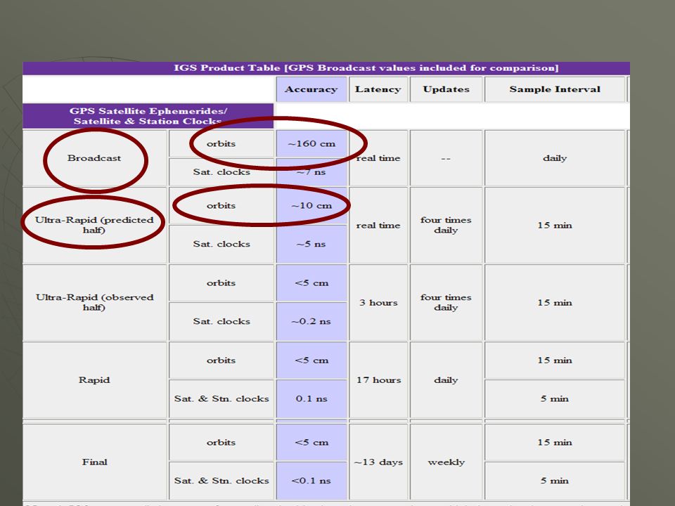
Comparison of Ephemerides Broadcast (predicted) Ephemeris Broadcast (predicted) Ephemeris Sent from GPS satellites as part of the navigation message when you are collecting data.Sent from GPS satellites as part of the navigation message when you are collecting data. Precises Emphemerides Precises Emphemerides Ultra-rapid EphemerisUltra-rapid Ephemeris ORGN Spider software grabs Ultra Rapid Emphemeris every few hours and applies to RT correctors transmitted by the ORGN. ORGN Spider software grabs Ultra Rapid Emphemeris every few hours and applies to RT correctors transmitted by the ORGN. Rapid EphemerisRapid Ephemeris Final Precise EphemerisFinal Precise Ephemeris

54
FAQ: Why am I not Hitting my Old Control Points when using correctors from the ORGN?

55
Outreach/Education OSU Workshop: Using the ORGN: Feb 2008OSU Workshop: Using the ORGN: Feb 2008 PLSO Conference: Getting Started with the ORGN:March 2008PLSO Conference: Getting Started with the ORGN:March 2008 ODOT Surveyors Conference: April 2008ODOT Surveyors Conference: April 2008

56
Site Calibration Calibrate to points that surround the project that have coordinates known in the local system. Calibrate to points that surround the project that have coordinates known in the local system. Occupy calibration points with GPS while receiving real-time correctors from the ORGN, then calibrate to the local system. Occupy calibration points with GPS while receiving real-time correctors from the ORGN, then calibrate to the local system.

57
FAQ: Why am I not hitting published HARN positions when I use correctors from the ORGN?

58
NGS has adopted a realization of NAD 83 called NAD 83 (NSRS 2007) for over 70,000 passive monuments (HARN brass caps). NGS has adopted a realization of NAD 83 called NAD 83 (NSRS 2007) for over 70,000 passive monuments (HARN brass caps). This realization approximates (but is not, and can never be equivalent to) the more rigorously defined NAD 83 (CORS 96) in which CORS and OPUS (and Oregon Real-time GPS Network) coordinates are distributed. NGS This realization approximates (but is not, and can never be equivalent to) the more rigorously defined NAD 83 (CORS 96) in which CORS and OPUS (and Oregon Real-time GPS Network) coordinates are distributed. NGS
 for over 70,000 passive monuments (HARN brass caps). This realization approximates (but is not, and can never be equivalent to) the more rigorously defined NAD 83 (CORS 96) in which CORS and OPUS (and Oregon Real-time GPS Network) coordinates are distributed. NGS This realization approximates (but is not, and can never be equivalent to) the more rigorously defined NAD 83 (CORS 96) in which CORS and OPUS (and Oregon Real-time GPS Network) coordinates are distributed. NGS.")
59
Distortion Due to Elevation 23 23 GPS Derived Coordinate State Plane Coordinate LDP Coordinate Local Datum Plane State Plane 230 Feet 973.444 Feet 973.504 Feet 0.06 Feet

60
Distortion Due to Elevation 23 23 GPS Derived Coordinate State Plane Coordinate LDP Coordinate Local Datum Plane State Plane 5,000 Feet 973.444 Feet 973.726 Feet 0.28 Feet

61
Low Distortion Projections Workshop November 4, 2008 Albany, Oregon Co-sponsors: Oregon GPS Users GroupOregon GPS Users Group Oregon DOT Geometronics UnitOregon DOT Geometronics Unit More info: www.ogug.netMore info: www.ogug.net

62
Ken Bays Ken Bays kenneth.bays@odot.state.or.us kenneth.bays@odot.state.or.us kenneth.bays@odot.state.or.us 503-986-3543 503-986-3543 www.TheORGN.net www.TheORGN.net

63
NAD 83( CORS 96) and NAD 83(NSRS2007) NGS has adopted a realization of NAD 83 called NAD 83(NSRS2007) for the distribution of coordinates of the High Accuracy Reference Networks (HARN) ~70,000 passive geodetic control monuments. NGS has adopted a realization of NAD 83 called NAD 83(NSRS2007) for the distribution of coordinates of the High Accuracy Reference Networks (HARN) ~70,000 passive geodetic control monuments. This realization approximates (but is not, and can never be, equivalent to) the more rigorously defined NAD 83 (CORS 96) realization in which Continuously Operating Reference Station (CORS) coordinates are and NGS Online Positioning User Service (OPUS) coordinates are distributed. This realization approximates (but is not, and can never be, equivalent to) the more rigorously defined NAD 83 (CORS 96) realization in which Continuously Operating Reference Station (CORS) coordinates are and NGS Online Positioning User Service (OPUS) coordinates are distributed. NAD 83(NSRS2007) was created by adjusting GPS data collected during various campaign- style geodetic NAD 83(NSRS2007) was created by adjusting GPS data collected during various campaign- style geodetic surveys performed between the mid-1980's and 2005. surveys performed between the mid-1980's and 2005. For this adjustment, NAD 83 (CORS 96) positional coordinates for ~700 CORS were held fixed (predominantly at the 2002.0 epoch. for the stable north American plate, but 2007.0 in Alaska and western CONUS) to obtain consistent positional coordinates for the ~70,000 passive marks, as described by Vorhauer [2007]. Derived NAD 83(NSRS2007) positional coordinates should be consistent with corresponding NAD 83( CORS 96) positional coordinates to within the accuracy of the GPS data used in the adjustment and the accuracy of the corrections applied to these data for systematic errors, such as refraction. For this adjustment, NAD 83 (CORS 96) positional coordinates for ~700 CORS were held fixed (predominantly at the 2002.0 epoch. for the stable north American plate, but 2007.0 in Alaska and western CONUS) to obtain consistent positional coordinates for the ~70,000 passive marks, as described by Vorhauer [2007]. Derived NAD 83(NSRS2007) positional coordinates should be consistent with corresponding NAD 83( CORS 96) positional coordinates to within the accuracy of the GPS data used in the adjustment and the accuracy of the corrections applied to these data for systematic errors, such as refraction. In particular, there were no corrections made to the observations for vertical crustal motion when converting from the epoch of the GPS survey into the epoch of the adjustment, while the NAD 83 ( CORS 96) coordinates do reflect motion in all three directions at CORS sites. For this reason alone, there can never be total equivalency between NAD 83(NSRS2007) and NAD 83( CORS 96). In particular, there were no corrections made to the observations for vertical crustal motion when converting from the epoch of the GPS survey into the epoch of the adjustment, while the NAD 83 ( CORS 96) coordinates do reflect motion in all three directions at CORS sites. For this reason alone, there can never be total equivalency between NAD 83(NSRS2007) and NAD 83( CORS 96). Note: NGS has not computed NAD 83(NSRS2007) velocities for any of the ~70,000 passive marks involved in this adjustment. Also, the positional coordinates of a passive mark will make reference to an epoch date. Epoch dates are the date for which the positional coordinates were adjusted, and are therefore considered valid (within the tolerance of not applying vertical crustal motion). Because a mark's positional coordinates will change due to the dynamic nature of the earth's crust, the coordinate of a mark on epochs different than the listed epoch date can only be accurately known if a 3-dimensional velocity has been computed and applied to that mark. Note: NGS has not computed NAD 83(NSRS2007) velocities for any of the ~70,000 passive marks involved in this adjustment. Also, the positional coordinates of a passive mark will make reference to an epoch date. Epoch dates are the date for which the positional coordinates were adjusted, and are therefore considered valid (within the tolerance of not applying vertical crustal motion). Because a mark's positional coordinates will change due to the dynamic nature of the earth's crust, the coordinate of a mark on epochs different than the listed epoch date can only be accurately known if a 3-dimensional velocity has been computed and applied to that mark.
 for the distribution of coordinates of the High Accuracy Reference Networks (HARN) ~70,000 passive geodetic control monuments. This realization approximates (but is not, and can never be, equivalent to) the more rigorously defined NAD 83 (CORS 96) realization in which Continuously Operating Reference Station (CORS) coordinates are and NGS Online Positioning User Service (OPUS) coordinates are distributed. This realization approximates (but is not, and can never be, equivalent to) the more rigorously defined NAD 83 (CORS 96) realization in which Continuously Operating Reference Station (CORS) coordinates are and NGS Online Positioning User Service (OPUS) coordinates are distributed. NAD 83(NSRS2007) was created by adjusting GPS data collected during various campaign- style geodetic NAD 83(NSRS2007) was created by adjusting GPS data collected during various campaign- style geodetic surveys performed between the mid-1980 s and surveys performed between the mid-1980 s and For this adjustment, NAD 83 (CORS 96) positional coordinates for ~700 CORS were held fixed (predominantly at the epoch. for the stable north American plate, but in Alaska and western CONUS) to obtain consistent positional coordinates for the ~70,000 passive marks, as described by Vorhauer [2007]. Derived NAD 83(NSRS2007) positional coordinates should be consistent with corresponding NAD 83( CORS 96) positional coordinates to within the accuracy of the GPS data used in the adjustment and the accuracy of the corrections applied to these data for systematic errors, such as refraction. For this adjustment, NAD 83 (CORS 96) positional coordinates for ~700 CORS were held fixed (predominantly at the epoch. for the stable north American plate, but in Alaska and western CONUS) to obtain consistent positional coordinates for the ~70,000 passive marks, as described by Vorhauer [2007]. Derived NAD 83(NSRS2007) positional coordinates should be consistent with corresponding NAD 83( CORS 96) positional coordinates to within the accuracy of the GPS data used in the adjustment and the accuracy of the corrections applied to these data for systematic errors, such as refraction. In particular, there were no corrections made to the observations for vertical crustal motion when converting from the epoch of the GPS survey into the epoch of the adjustment, while the NAD 83 ( CORS 96) coordinates do reflect motion in all three directions at CORS sites. For this reason alone, there can never be total equivalency between NAD 83(NSRS2007) and NAD 83( CORS 96). In particular, there were no corrections made to the observations for vertical crustal motion when converting from the epoch of the GPS survey into the epoch of the adjustment, while the NAD 83 ( CORS 96) coordinates do reflect motion in all three directions at CORS sites. For this reason alone, there can never be total equivalency between NAD 83(NSRS2007) and NAD 83( CORS 96). Note: NGS has not computed NAD 83(NSRS2007) velocities for any of the ~70,000 passive marks involved in this adjustment. Also, the positional coordinates of a passive mark will make reference to an epoch date. Epoch dates are the date for which the positional coordinates were adjusted, and are therefore considered valid (within the tolerance of not applying vertical crustal motion). Because a mark s positional coordinates will change due to the dynamic nature of the earth s crust, the coordinate of a mark on epochs different than the listed epoch date can only be accurately known if a 3-dimensional velocity has been computed and applied to that mark. Note: NGS has not computed NAD 83(NSRS2007) velocities for any of the ~70,000 passive marks involved in this adjustment. Also, the positional coordinates of a passive mark will make reference to an epoch date. Epoch dates are the date for which the positional coordinates were adjusted, and are therefore considered valid (within the tolerance of not applying vertical crustal motion). Because a mark s positional coordinates will change due to the dynamic nature of the earth s crust, the coordinate of a mark on epochs different than the listed epoch date can only be accurately known if a 3-dimensional velocity has been computed and applied to that mark..")
Similar presentations


, and GEOID 12 in Alabama Overview of Height Modernization Project Overview of Height Modernization.>")


 and the Defense Mapping School Reviewed by:____________ Date:_________ Objective:>")


