Download presentation
Presentation is loading. Please wait.

1
Earthquakes Chapter 6

2
6.1- Forces in Earth’s Crust
Stress- A force that acts on rock to change its shape or volume, works over millions of years Types of Stress: Tension- pulls on crust, stretching rock Compression- Squeeze rock until folds or breaks Shearing- pushes a mass of rock in 2 opposite directions

4
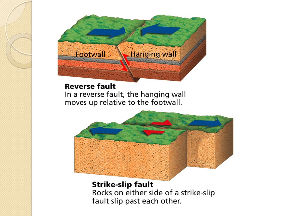
Kinds of Faults Fault- a break in the rock of the crust where rock surfaces slip past each other Most faults occur along plate boundaries where the forces of plate motion push or pull the crust so much that the crust breaks Three main types: Normal Faults- the fault is at an angle, so one block lies above (hanging wall) and one block lies below (footwall) Caused by tension in Earth’s crust that pulls rocks apart
 and one block lies below (footwall) Caused by tension in Earth’s crust that pulls rocks apart.")
6
Kinds of Faults 2. Reverse Fault- Where rock of the crust is pushed together, caused by compression Same structure as a normal fault but blocks move in opposite directions Strike-Slip Fault- Where plates move past each other, caused by shearing Rocks on either side of the fault slip past each other sideways, with little up and down motion If it forms the boundary between 2 plates, then called a transform boundary

8
Changing Earth’s Surface
Over millions of years, the forces of plate movement can change a flat plain into landforms such as anticlines, and synclines, folded mountains, fault-block mountains, and plateaus. Folds- Bends in rock formed when compression shortens and thickens part of Earth’s crust Anticline- bends upward into an arch Syncline- bends downward to form a valley Ex. Appalachian Mtns., Himalayas, Alps

9
Changing Earth’s Surface
Fault-Block Mountain- When 2 normal faults cut through a block of rock; when 2 normal faults form parallel to each other, a block of rock is left lying between them, the block then moves upward Ex. Great Basin Plateau- a large area of flat land elevated high above sea level Form when forces in Earth’s crust push up a large, flat block of rock Ex. Colorado Plateau

10
6.2- Earthquakes and Seismic Waves
Earthquake- the shaking and trembling that results from the movement of rock beneath Earth’s surface Caused by the forces of plate movement Produce stress in crust, adding energy Stress increases along a fault until rock breaks Earthquake begins

11
Most Earthquakes begin in lithosphere within 100 km of Earth’s surface
Focus- area beneath Earth’s surface where rock is under stress Epicenter- the point on the surface directly above the focus

12
Types of Seismic Waves Waves carry energy as they travel outward
Seismic waves- vibrations that travel through Earth carrying the energy released during an Earthquake through the interior and across the surface P-waves- (primary waves) seismic waves that compress and expand the ground
 seismic waves that compress and expand the ground.")
13
Types of Seismic Waves S-waves- (secondary waves) seismic waves that vibrate from side-to-side and up and down; they shake the ground back and forth Cannot move through liquids Surface Waves- move more slowly than P- waves and S-waves, but can produce sever ground movements
 seismic waves that vibrate from side-to-side and up and down; they shake the ground back and forth. Cannot move through liquids. Surface Waves- move more slowly than P- waves and S-waves, but can produce sever ground movements.")
14
Measuring Earthquakes
There are at least 20 different measures for rating earthquakes Mercalli Scale- rate earthquakes according to the level of damage at a given place Magnitude- a number that geologists assign to an earthquake Richter Scale- a rating of an earthquakes magnitude based on the size of the earthquake’s seismic waves

15
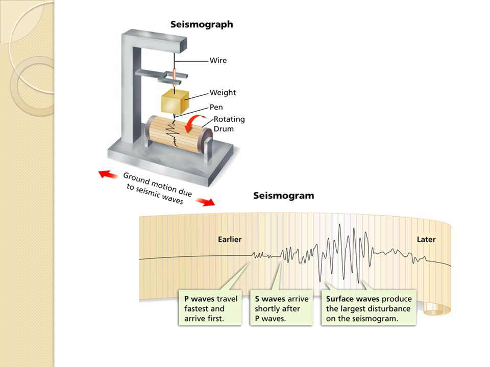
Seismograph- an instrument that records and measures seismic waves
Moment magnitude scale- a rating system that estimates the total energy released by an earthquake Used to rate all sizes, near or far Geologists study data from seismographs Each one-point increase in magnitude releases roughly 32 times more energy Below 3- barely notice Below 5- small, little damage Above 6- great damage 8 or above- rare

16
Mercalli Scale

17
Locating the Epicenter
Geologists use seismic waves to locate an earthquake’s epicenter Scientists measure the difference between arrival times of the P waves and S waves Geologists then draw at least 3 circles, the center of each circle is a particular seismograph’s location The point where the three circles intersect is the location of the epicenter

19
6.3- Monitoring Earthquakes
Seismic waves cause the seismograph’s drum to vibrate. But the suspended weight with the pen attached moves very little. Therefore, the pen stays in place and records the drum’s vibrations A seismograph’s heavy weight resists motion during a quake, but the rest of the instrument vibrates when seismic waves arrive Seismogram- the record of an earthquake’s seismic waves Height of the lines is greater for more severe EQ

21
Instruments That Monitor Faults
In trying to predict earthquakes, geologists have developed instruments to measure changes in elevation, tilting of the land surface, and ground movements along faults. Tiltmeter- measures tilting or raising of the ground Creep Meter- uses wire stretched across a fault to measure horizontal movement of the ground Laser-Ranging Devices- uses a laser beam to detect horizontal fault movements GPS satellites- Earth-orbiting satellites that monitor changes in elevation and horizontal movement

22
GPS Satellites

23
Using Seismographic Data
Seismographs and fault-monitoring devices provide data to: Map faults Detect changes along faults Predict Earthquakes

24
6.4- Earthquake Safety Geologists can determine earthquake risk by locating where faults are active and where past earthquakes have occurred In the US, the risk is highest along the Pacific Coast The eastern U.S. has a low risk because they are far from plate boundaries, but has experienced some of most powerful quakes. Maybe because the continental plate below N. America is under stress

25
How Earthquakes Cause Damage
Shaking- can trigger landslides or avalanches, damage or destroy structures Liquefaction- occurs when an earthquake’s violent shaking suddenly turns loose, soft soil into liquid mud Aftershocks- an earthquake that occurs after a larger earthquake in the same area Tsunamis- the water displaced by the earthquake can form a large wave

26
Steps to Earthquake Safety
The main danger is from falling objects and flying glass Drop, Cover, and Hold Designing Safer Buildings To reduce earthquake damage, new buildings must be made stronger and more flexible. Older buildings may be modified to withstand stronger quakes.

Similar presentations