Download presentation
Presentation is loading. Please wait.

1
John Hoffmann Introduction to USGS Arizona Program and Hydrology USGSGeologyMappingBiologyWater Water-Science Centers

2
USGS Water-Science Center Physical Setting Offices, staff, funding Hydrology Programs Laws influencing programs Example programs

3
AZWSC Organization and Staff Program/ support group AZWSC, main office Tucson (~70 total) Tucson Field Office Office for Northern AZ Programs Tempe Field Office Yuma Field Office Hydrologic Data Program 67898 Hydrologic Investigations & Research Programs 238 Administrative Services and Computer Support 8
 Tucson Field Office Office for Northern AZ Programs Tempe Field Office Yuma Field Office Hydrologic Data Program Hydrologic Investigations & Research Programs 238 Administrative Services and Computer Support 8")
4
AZWSC Funding, FY06 Total Funding Estimate: $10 million Cooperators }

5
The importance of understanding Arizona’s water resources T O F T O T A L U. S. P O P U L A T I O N POPULATION IN SOUTHWEST PERCENT OF U.S. POPULATION

7
Importance of Ground-Water to the West Percentage of drinking water supplied by ground water

8
Ground-water resources of Arizona

10
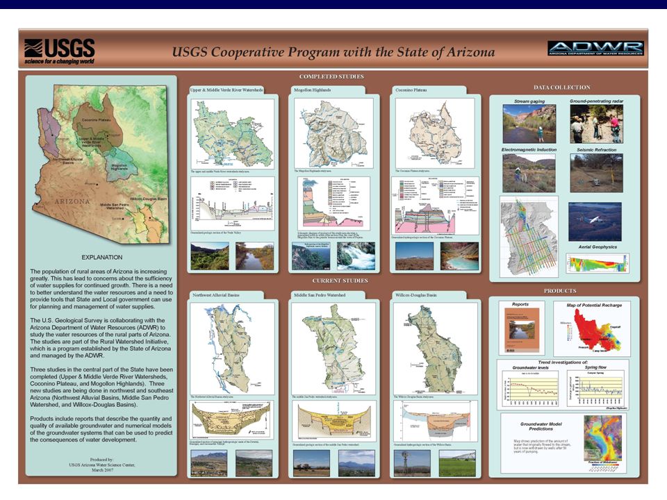
Alluvial basins (Basin and Range physiographic province) 72 basins—primary source of ground water; 900 million acre-ft Filled with sediments ranging from a few thousand to 10,000 ft thick Basins categorized to allow transfer of information and allow investigators to make predictions about the impacts of future development within each group Note: Mountain ranges surrounding the basins are crystalline and yield little to no water
 72 basins—primary source of ground water; 900 million acre-ft Filled with sediments ranging from a few thousand to 10,000 ft thick Basins categorized to allow transfer of information and allow investigators to make predictions about the impacts of future development within each group Note: Mountain ranges surrounding the basins are crystalline and yield little to no water")
11
SPRINGS Low- permeability rocks Flow system conceptual model: Colorado Plateau SPRINGS

12
Influence of Laws on USGS AzWSC Program (Melcher) y Colorado Rover Compact, 1922 y CR Storage Project Act, 1956 y Supreme Court Decree Act, 1956 y Grand Canyon Protection Act, 1992; y National Environmental Policy Act, 1969; 18 others y Endangered Species Act, 1973 y Arizona Groundwater Management Act, 1980/Rural Watershed Initiative y Nuclear Water Policy Act, 1982 y Clean Water Act, 1989 y Section 321 of the Defense Authorization Bill, 2004 y Title II of Yavapai County land Exchange Bill, 2005 y Transboundary Aquifer Bill, 2006 y Lower Colorado River Decree Accounting Project y Grand Canyon Sediment transport Project, y C aquifer Project y Rural Watershed Investigations y Aquifer Storage an Subsidence Project y Death Valley Regional GW Flow Model y Urban Runoff y San Pedro River y Verde River Watershed y Border aquifers LawProgram Water-management related
 y Colorado Rover Compact, 1922 y CR Storage Project Act, 1956 y Supreme Court Decree Act, 1956 y Grand Canyon Protection Act, 1992; y National Environmental Policy Act, 1969; 18 others y Endangered Species Act, 1973 y Arizona Groundwater Management Act, 1980/Rural Watershed Initiative y Nuclear Water Policy Act, 1982 y Clean Water Act, 1989 y Section 321 of the Defense Authorization Bill, 2004 y Title II of Yavapai County land Exchange Bill, 2005 y Transboundary Aquifer Bill, 2006 y Lower Colorado River Decree Accounting Project y Grand Canyon Sediment transport Project, y C aquifer Project y Rural Watershed Investigations y Aquifer Storage an Subsidence Project y Death Valley Regional GW Flow Model y Urban Runoff y San Pedro River y Verde River Watershed y Border aquifers LawProgram Water-management related")
14
Aquifer-Storage Change and Subsidence Monitoring Stations in the TAMA Directed by Arizona ground- water law ( Arizona Groundwater Management Act, 1980) to attain an annual balance between ground-water withdrawals (Q out ) and recharge (Q in ) by the year 2025 Q in = Q out ΔStorage = 0 Q in – Q out = ΔStorage
 to attain an annual balance between ground-water withdrawals (Q out ) and recharge (Q in ) by the year 2025 Q in = Q out ΔStorage = 0 Q in – Q out = ΔStorage")
15
Original Water Table Volume of Aquifer Drained Aquifer Storage Change Specific Yield × Water Table After Pumping Aquifer Storage Change

16
g = -k x/mass xx Gravity The simplest type of gravimeter essentially measures the extension of a spring attached to a control mass. unconfined aquifer Δ water table before pumping water table after pumping Δ

17
-60,000 acre-ft ~0.4 ft per year Storage Change in a portion of the Tucson Basin Spring 2005 – Summer 2006 Q in – Q out = ΔStorage

21
Determine the Effects of Ground-Water Overdraft on: Aquatic Communities Riparian Areas Endangered Species

22
Theoretical capture by pumping for 50 years Upper San Pedro Basin in SE Arizona

23
Introduction to USGS Arizona Program and Hydrology Questions? Next up: Jim Leenhouts--San Pedro James Callagary—Geophysical tools

Similar presentations


>")


