Download presentation
Presentation is loading. Please wait.

1
Water Resources Development In Central Part Of India By Arthee.V Bte-06-004

2
Introduction: Situated in the centre of India It is the largest geographic unit of the country average rainfall of 76 to 150 cm Narmada, Tapti, Mahanadi, and Mahi Sub-catchments -the Ganga, Yamuna, Godavari and Brahmani rivers. Rivers originating from the highlands of Madhya Pradesh drain out in three different directions.

3
Narmada basin with its mainstream runs across the State from east to west, receiving tributaries on either side The Mahanadi flows eastwards and the Tapti cuts across the State diagonally in a southwesterly direction to enter the Bay of Bengal. The rivers, tributary, rivulet and streams in the State have a combined length of 12 000 km.

4
During the monsoons, all the rivers in Madhya Pradesh turn into raging torrents, carrying enormous quantities of water. During the dry season, they shrink to rivulet. Thus, harnessing of water for irrigation and power generation is more relevant in the State, than anywhere else in India and its track record in tapping the water resources has been impressive.

5
RESERVOIR RESOURCES OF MADHYA PRADESH Madhya Pradesh, with its 0.46 million ha of reservoirs, has the maximum waterspread under man-made lakes of all Indian States. Gandhisagar reservoir is the second largest reservoir (in area) in the country.
 in the country..")
6
Description of 32 reservoirs comprising 6 small, 21 medium and 5 large (Fig. 7.1), covering a total area of 173 901 ha, is available. The average size of these small, medium and large reservoirs is 350, 2 527 and 23 661 ha respectively
, covering a total area of ha, is available. The average size of these small, medium and large reservoirs is 350, and ha respectively.")
7
Average size of different categories of reservoirs CategoryTotal Area (ha ) Number on units, areas of which are known Area (ha)Average of a unit (ha) Small172 57562102350 Medium169 50221534922527 Large118 3075 2366 TOTAL460 384321739075434
 Number on units, areas of which are known Area (ha)Average of a unit (ha) Small Medium Large TOTAL")
8
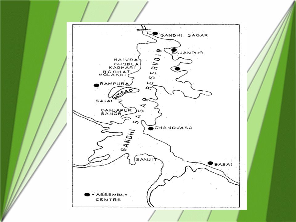
GANDHISAGAR RESERVOIR Gandhisagar reservoir is impounded on the river Chambal, which is the largest tributary of Yamuna, a component of the Ganga river system The river, at the dam site, receives catchment from the Vindhya ranges in the south and Aravalli in the northeast, covering a drainage area of 23 025 km2. Gandhisagar is one among the four hydraulic structures conceived as a part of the Integrated Chambal Development Programme, the other three being Ranapratapsagar, Jawaharsagar and the Kota barrage

10
Gandhisagar is the best-managed reservoir in the State for fisheries. stocking, though inadequate has been regular ever since the programme was iniated in 1959–60 (Table 7.4). The impact of stocking has been phenomenal. The fish yield from the reservoir fluctuated from 0.51 kg ha-1 during 1962–63 to the level of 12 to 13 kg ha-1 during 1978–79 and 1979–80
. The impact of stocking has been phenomenal. The fish yield from the reservoir fluctuated from 0.51 kg ha-1 during 1962–63 to the level of 12 to 13 kg ha-1 during 1978–79 and 1979–80.")
11
The State Government plans to increase the stocking rate to 200 ha-1 to achieve a target of 2 640 to 3 960 t (40 to 60 kg ha-1 ).
.")
12
Mode of exploitation The fishing rights for the reservoirs were handed over to a public sector corporation in 1980. Prior to that, fishing was done either by the cooperative societies or a group of fishermen from whom a royalty ranging from Rs. 0.80 to Rs. 3.50 was charged by the Government. The royalty rate varied with fish groups.

13
There were two types of cooperative societies, viz., the primary cooperatives and apex society The royalty system had many drawbacks, the fishermen did not get adequate income. middlemen and merchants made considerable profit. the cooperatives could not effectively undertake the market functions, and non-payment by the merchants/societies deprived the Government of its income in the form of royalty. It is estimated that while the Government earned Rs.2.87 million on royalty, more than one million was spent on its collection.

14
Since 1980, the Madhya Pradesh State Fisheries Development Corporation (MPSFDC), a public sector undertaking has taken over the functions of the apex cooperatives. The primary societies are now actively involved in fishing, their members fishing on a catch-sharing basis.

15
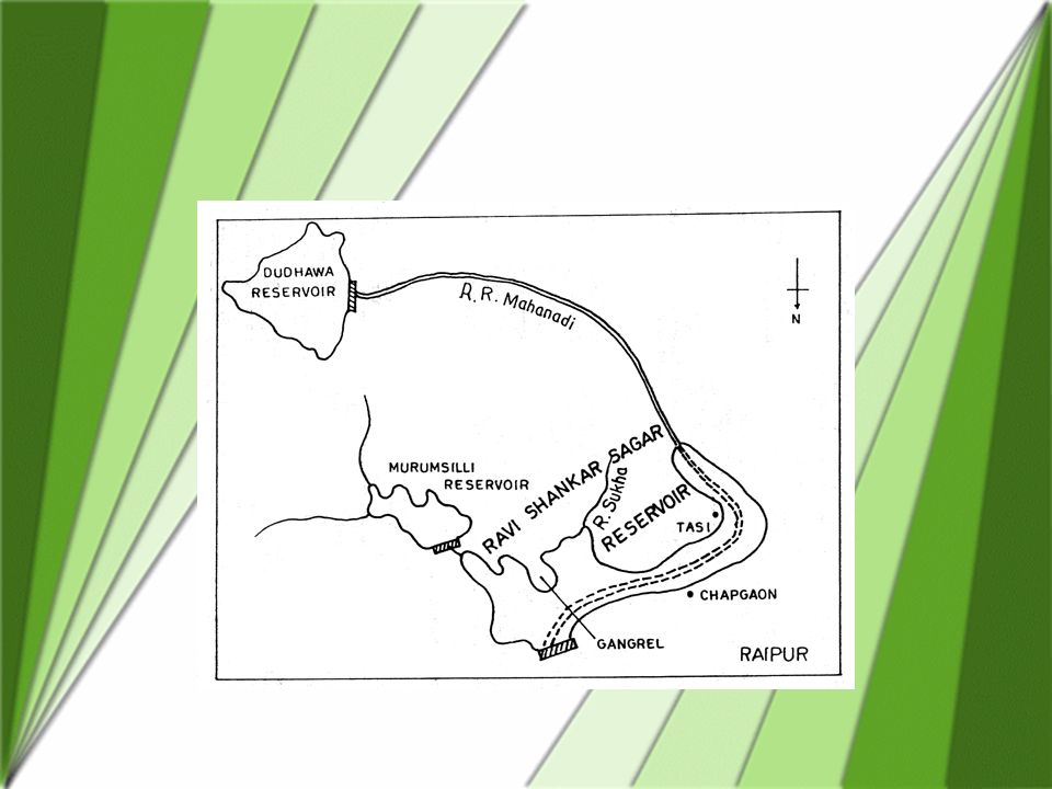
3 RAVISHANKARSAGAR Ravishankarsagar reservoir was formed in 1978, on the river Mahanadi, at 20° 38' N, 81° 34' E, 92 km south of the city of Raipur. A multi-purpose reservoir, serving irrigation, hydro-electric power-generation and the industrial requirements Steel Plant,. The lowest water spread during the lean season is 3 220 ha. Total catchment area is estimated at 3 620 km2, of which 625 km2 is intercepted by the upstream dam,). At full level, the reservoir holds 909 million m3 of water (mean depth of 9.53 m). Maximum depth is 32 m.
. At full level, the reservoir holds 909 million m3 of water (mean depth of 9.53 m). Maximum depth is 32 m..")
16
. One salient hydrographic feature of this reservoir is the continuous drawdown for industrial, irrigation and hydel purposes. Water level fluctuates by 3 to 5 m in a year The sediments of Ravishankarsagar is poor in nutrients and organic matter. With respect to the available nitrogen (12 to 30 mg 100 g-1) and organic carbon (0.2–1.2%), the reservoir has a low productivity, but the level of phosphorus (2.7 to 8.0 mg 100 g-1) suggests a high productivity.
 and organic carbon (0.2–1.2%), the reservoir has a low productivity, but the level of phosphorus (2.7 to 8.0 mg 100 g-1) suggests a high productivity..")
Similar presentations


>")


>")


 Power Plant>")
