Download presentation
Presentation is loading. Please wait.

1
StreamStats: A Web- Based Tool for Estimating Streamflow Statistics by Alan Rea and Pete Steeves

2
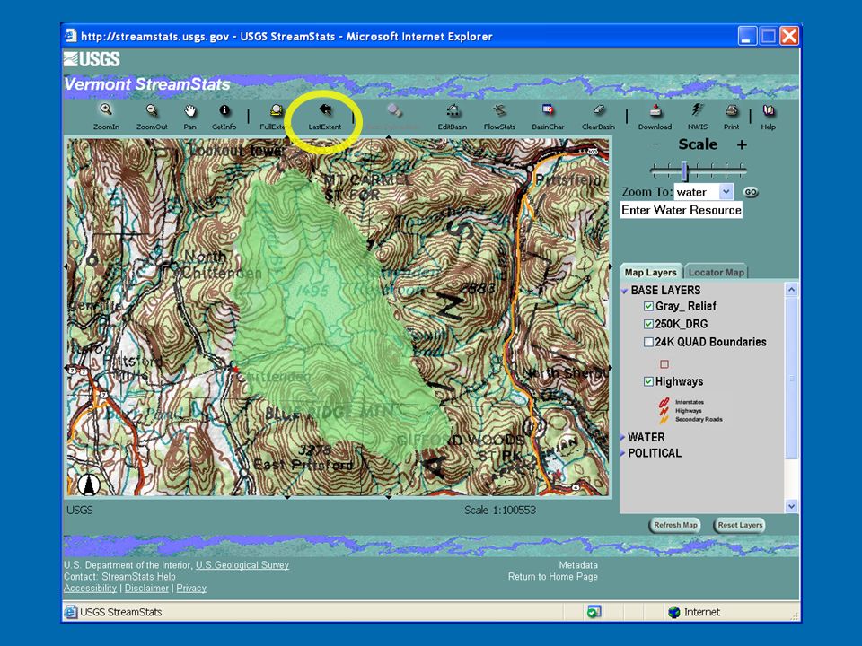
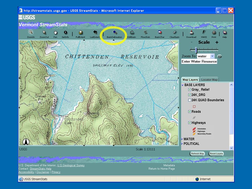
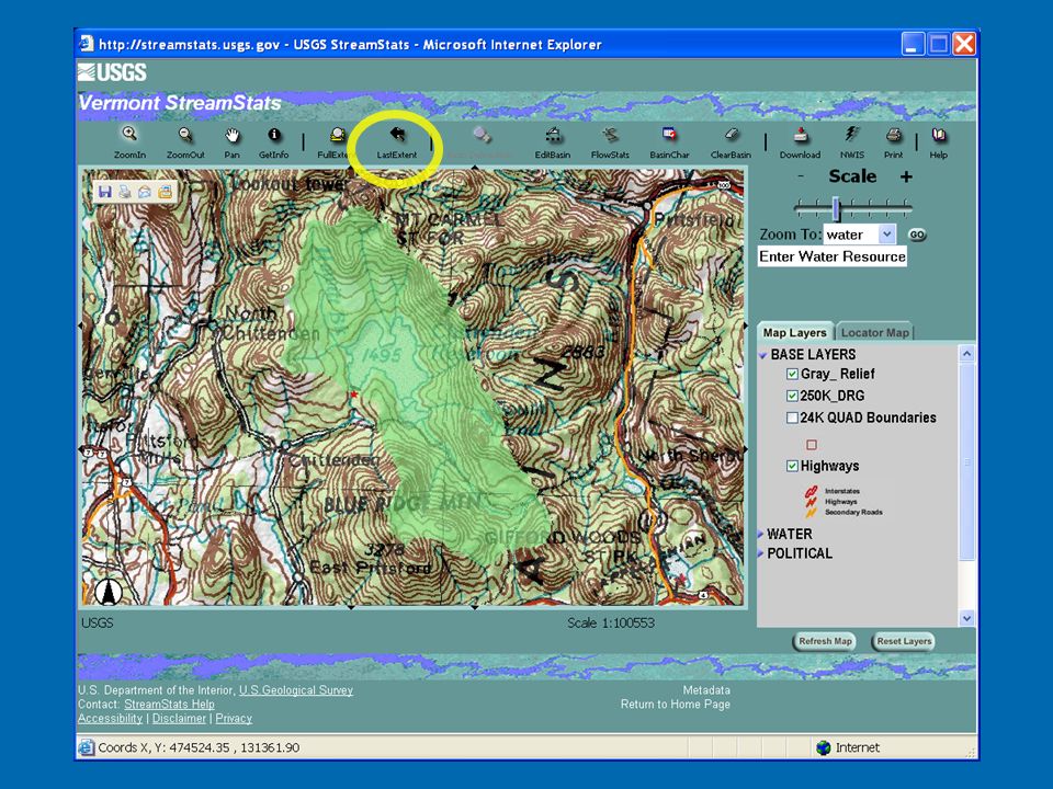
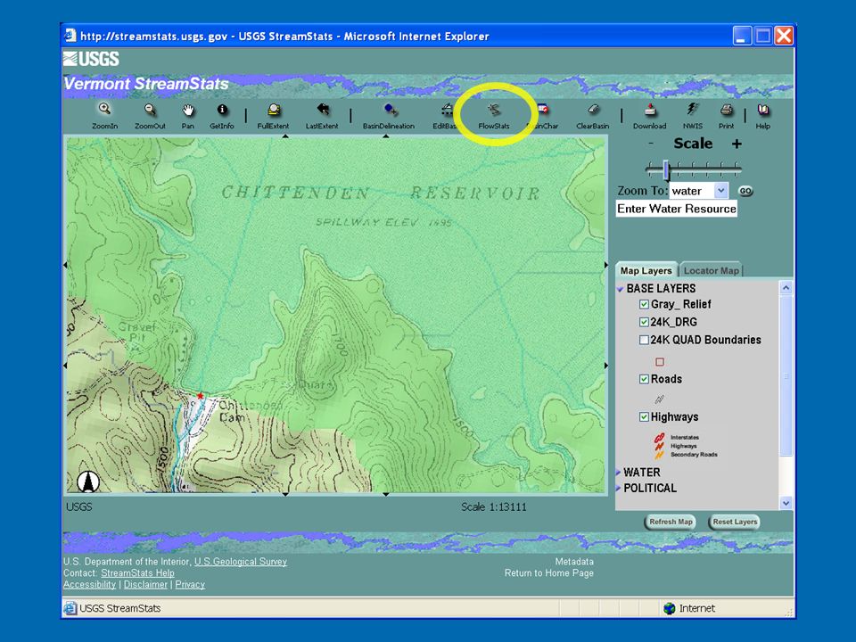
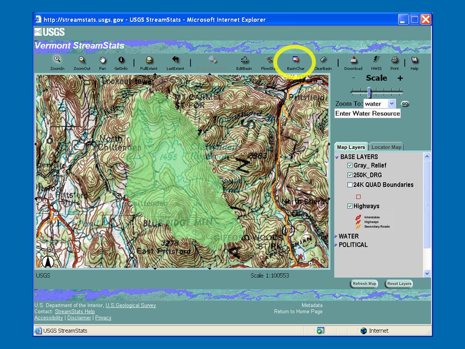
General description of StreamStats Web application for stream-flow statistics and basin characteristics GIS-like interface Provides access to GIS data and methods Gage site and ungaged site procedures Provides fast, consistent, reproducible results

3
National StreamStats Status 9 states up and running National gages web site 8-10 more states plan to start up in FY07 Data upgrades on 3 states (PA, ID, WA) Each state is developed (and funded) separately
 Each state is developed (and funded) separately")
4
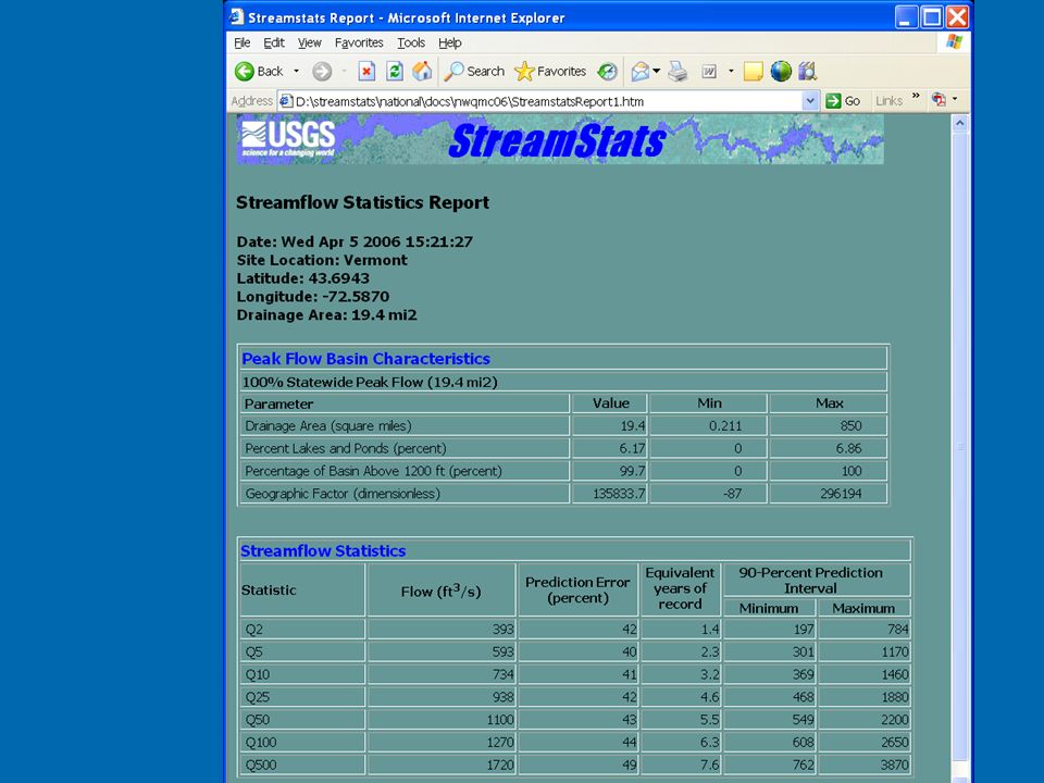
Overview—Streamflow Statistics What—Estimate of streamflow under some condition, e.g. the 100-year flood flow Why—Engineering design flows for structures; many other applications How Computed— At stream gages: statistical analysis of historic flows Ungaged sites: Regression equations

5
Streamflow Regression Equations Regression equations take the form: Q 100 = 758A 0.643 P 0.286 (Wong, 1994) Drainage area is used in nearly all equations Other common variables include: Basin slope, relief, or mean elevation Basin slope, relief, or mean elevation Precipitation (mean annual; 2-year, 24-hour) Precipitation (mean annual; 2-year, 24-hour) Stream length or slope Stream length or slope Land use (forest area, wetland and water areas) Land use (forest area, wetland and water areas) Basin shape or orientation Basin shape or orientation Soils or surficial geology Soils or surficial geology
 Drainage area is used in nearly all equations Other common variables include: Basin slope, relief, or mean elevation Basin slope, relief, or mean elevation Precipitation (mean annual; 2-year, 24-hour) Precipitation (mean annual; 2-year, 24-hour) Stream length or slope Stream length or slope Land use (forest area, wetland and water areas) Land use (forest area, wetland and water areas) Basin shape or orientation Basin shape or orientation Soils or surficial geology Soils or surficial geology")
6
The benefit of GIS-based tools Cost—Reduce time to delineate and compute basin characteristics from hours to minutes Accuracy—Some measurements much better, others about the same as manual methods Consistency—Important for statistical validity Reproducibility—Different users will get same results Web-based tool provides broad access to: Large geospatial data bases Consistent methods and data

7
Some Caveats: Estimates are for natural streamflows, NOT Regulated flows, significant diversions/returns Regulated flows, significant diversions/returns Gaining/losing reaches, unusual ground-water influence Gaining/losing reaches, unusual ground-water influence Estimates are not valid for extrapolation outside limits of the regression input data (given in report) No long-term climate change assumed
 No long-term climate change assumed")
8
Application Examples Engineering Design—Bridges, culverts, flood-plain management Water and Land Management—Water rights adjudication, in-stream flows, fish passage/habitat studies Water Quality Regulation—Low flows, perennial vs. intermittent streams (TMDL’s, NPDES Permits) Sampling Network Design—Cover a range of desired flows
 Sampling Network Design—Cover a range of desired flows.")
20
The data behind StreamStats Data Sources (flexible) DEM DEM usually NED 10-musually NED 10-m Can use NHDPlus 30-m grids (Oregon, Wash.)Can use NHDPlus 30-m grids (Oregon, Wash.) NHD HiRes burned into DEM NHD HiRes burned into DEM WBD walls added to DEM if available WBD walls added to DEM if available Create DEM derivatives (flowdirection, flowaccumulation, etc.) Create DEM derivatives (flowdirection, flowaccumulation, etc.) Basin characteristic grids (precip, forest, etc.) Basin characteristic grids (precip, forest, etc.)
 DEM DEM usually NED 10-musually NED 10-m Can use NHDPlus 30-m grids (Oregon, Wash.)Can use NHDPlus 30-m grids (Oregon, Wash.) NHD HiRes burned into DEM NHD HiRes burned into DEM WBD walls added to DEM if available WBD walls added to DEM if available Create DEM derivatives (flowdirection, flowaccumulation, etc.) Create DEM derivatives (flowdirection, flowaccumulation, etc.) Basin characteristic grids (precip, forest, etc.) Basin characteristic grids (precip, forest, etc.)")
21
The data behind StreamStats (cont) Data are brought into ArcHydro using ArcHydro Tools Most vector data are vectorized DEM derivatives (synthetic hydro) Most vector data are vectorized DEM derivatives (synthetic hydro) Good alignment with NHD due to burning Good alignment with NHD due to burning Currently we do not use NHD directly Currently we do not use NHD directly Plan to add NHD reach/measure and navigation, event discovery Plan to add NHD reach/measure and navigation, event discovery Data are tiled to keep grids small Usually by 8-digit HUC Usually by 8-digit HUC “Global” database ties together HUCs “Global” database ties together HUCs Data can be updated one tile at a time Data can be updated one tile at a time
 Data are brought into ArcHydro using ArcHydro Tools Most vector data are vectorized DEM derivatives (synthetic hydro) Most vector data are vectorized DEM derivatives (synthetic hydro) Good alignment with NHD due to burning Good alignment with NHD due to burning Currently we do not use NHD directly Currently we do not use NHD directly Plan to add NHD reach/measure and navigation, event discovery Plan to add NHD reach/measure and navigation, event discovery Data are tiled to keep grids small Usually by 8-digit HUC Usually by 8-digit HUC Global database ties together HUCs Global database ties together HUCs Data can be updated one tile at a time Data can be updated one tile at a time")
22
Global Network

23
Global Directory Structure

24
StreamStats is State-Centric Most regression studies state-based Data needed for a state are built separately (stove-pipe) Data usually developed on state’s preferred projection Consequence: More difficult to integrate nationally
 Data usually developed on state’s preferred projection Consequence: More difficult to integrate nationally")
25
Tier 1 Consideration for Massachusetts

26
Tier 2 Consideration for Massachusetts

27
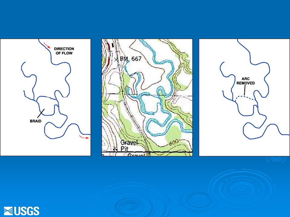
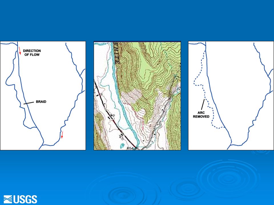
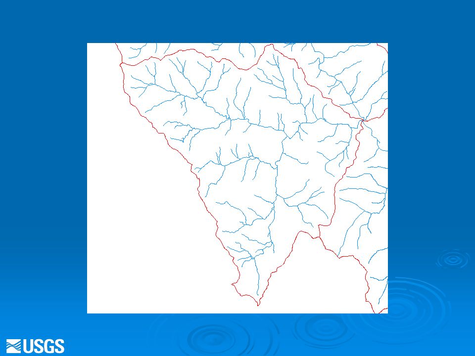
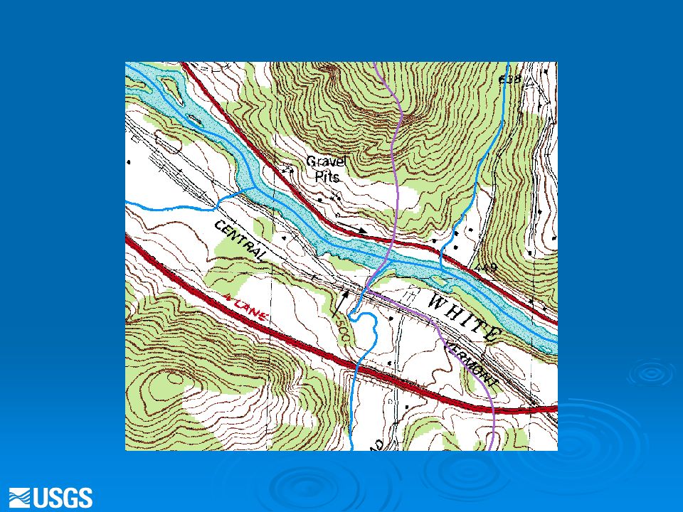
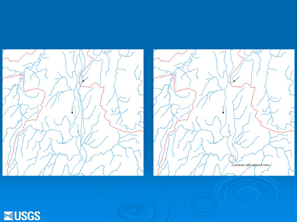
Preprocessing Data for StreamStats Includes (among other steps) …. Making a dendrite of the NHD for drainage enforcement (burning-in hydro) A consequence of skipping this step may be incorrect watershed delineations for locations on the braided sections of a network; headwaters that flow in 2 different directions; and at divergences/canals/ditches A consequence of skipping this step may be incorrect watershed delineations for locations on the braided sections of a network; headwaters that flow in 2 different directions; and at divergences/canals/ditches The dendrite was developed in joint maintenance with the WBD (feature comparisons resulted in modifications to both datasets on a case-by-case basis) The dendrite was developed in joint maintenance with the WBD (feature comparisons resulted in modifications to both datasets on a case-by-case basis) Canals and other man made structures are dealt with on a case by case basis Canals and other man made structures are dealt with on a case by case basis The objective to this processing was to develop datasets that would contribute to accurate watershed delineations The objective to this processing was to develop datasets that would contribute to accurate watershed delineations
 A consequence of skipping this step may be incorrect watershed delineations for locations on the braided sections of a network; headwaters that flow in 2 different directions; and at divergences/canals/ditches A consequence of skipping this step may be incorrect watershed delineations for locations on the braided sections of a network; headwaters that flow in 2 different directions; and at divergences/canals/ditches The dendrite was developed in joint maintenance with the WBD (feature comparisons resulted in modifications to both datasets on a case-by-case basis) The dendrite was developed in joint maintenance with the WBD (feature comparisons resulted in modifications to both datasets on a case-by-case basis) Canals and other man made structures are dealt with on a case by case basis Canals and other man made structures are dealt with on a case by case basis The objective to this processing was to develop datasets that would contribute to accurate watershed delineations The objective to this processing was to develop datasets that would contribute to accurate watershed delineations.")
28
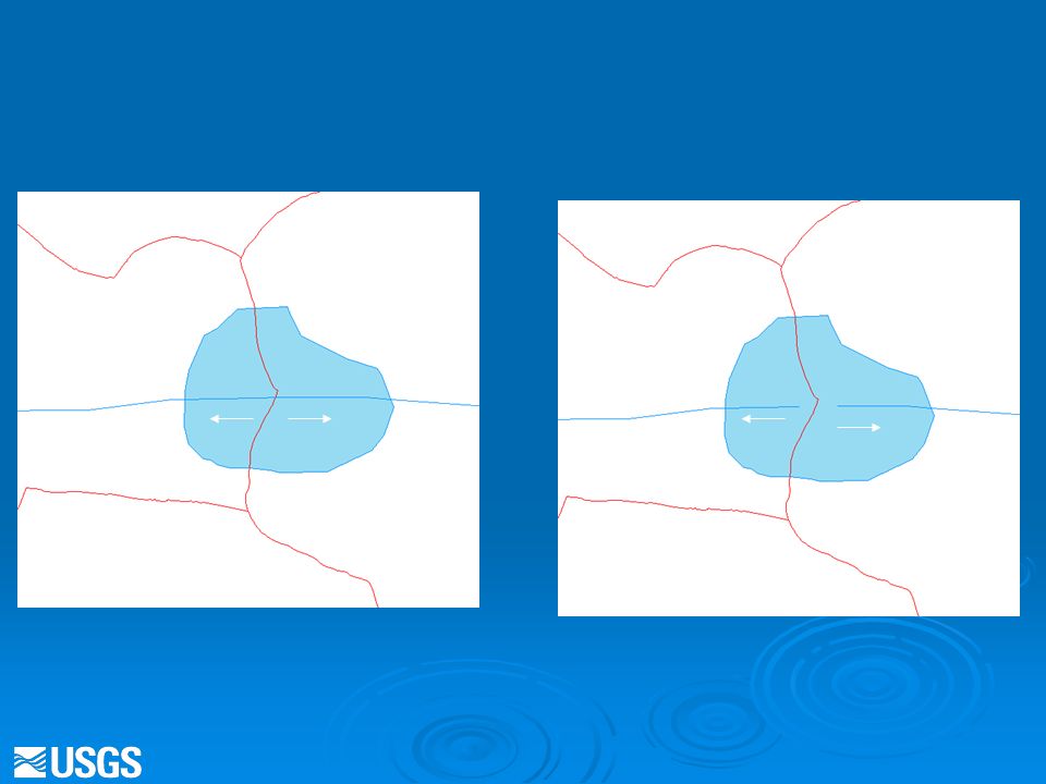
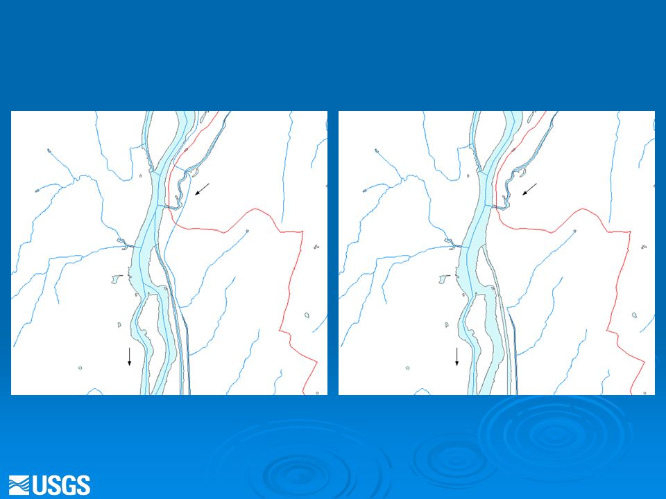
Definition of a Dendrite Network A dendrite is a connected flow network which, if built as a polygon feature class, would produce zero polygons

29
General Rules Reaches or parts of reaches could be removed from the NHD. However, features could not be modified in the NHD. The goal was to maintain a spatial link with the source data The goal was to maintain a spatial link with the source data Connectors could be added to the dendrite WBD inner boundaries could be modified Topographic maps were used in the editing process ** not all States developed a complete dendrite ** not all States developed a complete dendrite

30
Benefits to NHD Stewards Dendrite generated connectors could be used and incorporated into NHD updates VAA’s such as stream level and stream order could be assigned to NHD features in braided areas based on the dendrite data

41
NHD Navigation in StreamStats NHD functionality in StreamStats will include: Zoom to a reach and measure Zoom to a reach and measure Get reach/measure for watershed outlet Get reach/measure for watershed outlet Upstream/downstream tracing Upstream/downstream tracing Search on upstream/downstream point and linear events Search on upstream/downstream point and linear events Implemented as a web service

42
Prototype ArcGIS Server site NHD Navi- gation

43
NHD Navigation/Reach Indexing Streamgaging station User-selected site Dam site Point discharge Water withdrawal Explanation Biotic sampling site StreamStats will provide reach address, consisting of reach number and percentage along reach, for user-selected sites

44
For more info: StreamStats Web Site http://streamstats.usgs.gov/

Similar presentations


 fusion into DEM raster (burning in) - Sink removal - Flow direction - Flow.>")


