Download presentation
Presentation is loading. Please wait.

1
Integrating GIS & Lidar into the classroom time1 time2 difference

2
Where do landslides occur in Amity Creek? What contribution do they have to the fine sediment load of the river?

3
Tasks: 1.Field survey of landslide scars with GPS, noting width and height of scars 2.Import GPS data into ArcGIS 3.Calculate scar areas 4.Create a map that displays the data 5.Synthesis – where are the slides located? GIS skills learned: 1.Create new project 2.Import existing files 3.Import GPS data 4.Simple calculation of area 5.Map creation and export

4
Tasks: 1.Add historic air photos and channels 2.Digitize in recent channel 3.Make map showing channel migration 4.Make measurements of distance moved 5.Higher-order task: Figure out role of migration on sediment flux into channel (with focus on recently stabilized bend) New GIS skills learned: 1.Creating a shapefile 2.Digitizing on-screen 3.Measuring distance and area on-screen
 New GIS skills learned: 1.Creating a shapefile 2.Digitizing on-screen 3.Measuring distance and area on-screen")
5
Tasks: 1.Create hillshade from DEM 2.Make contour map 3.Make DEM semi-transparent 4.Overlay DEM on hillshade 5.Add contours 6.Make a map and export it New GIS skills learned: 1.DEM analyses – contours, hillshades 2.More visualization tools (transparency, labels) 3.How to make a cool topographic map
 3.How to make a cool topographic map")
6
Montgomery et al. 2001, Climate, tectonics, and morphology of the Andes

7
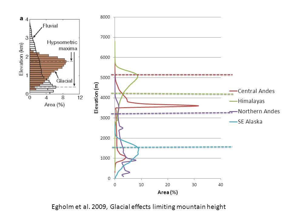
Egholm et al. 2009, Glacial effects limiting mountain height

Similar presentations


 732-7188 GIS and Mapping Procedures in ArcMap 9.x Creating an ArcMap Project Editing an ArcMap Project Printing an ArcMap Project.>")


 integrates hardware, software, and data for capturing, managing,>")


