Download presentation
Presentation is loading. Please wait.

1
UCF Augmented Navigation System

2
To develop an improved and more open navigation experience. Make it accessible to a broad audience through Android devices. To improve upon traditional 2D maps and voice turn-by- turn navigation.

3
Android based augmented reality navigation application. Includes: Android Application Hardware/Software Interface Expansion Sensor board

4
iOS vs. Android vs. Windows Phone 8 Which platform is the most open and familiar to the team? SDK features Programming Language familiarity Interfacing with Hardware Map Features

5
Panda Board ES vs Beagle Board-xM Panda Board ESBeagle Board-xM CPUDual-Core ARM A9 1.2 Ghz Single Core ARM Cortex A8 1.0 Ghz RAM1 GB512 MB VideoImagination SGX540Texas Instruments DM3730 ConnectivityWLAN bgn, Bluetooth, 10/100 Ethernet 10/100 Ethernet Video outDVI-D, HDMIDVI-D Price$162$149

6
Panda Board ES + Chipsee Expansion 7 inch LCD 800 x 400 5-point Capacitive Touch 5 User Keys (useful for Android OS) Linaro Android OS 4.0.3
 Linaro Android OS 4.0.3")
7
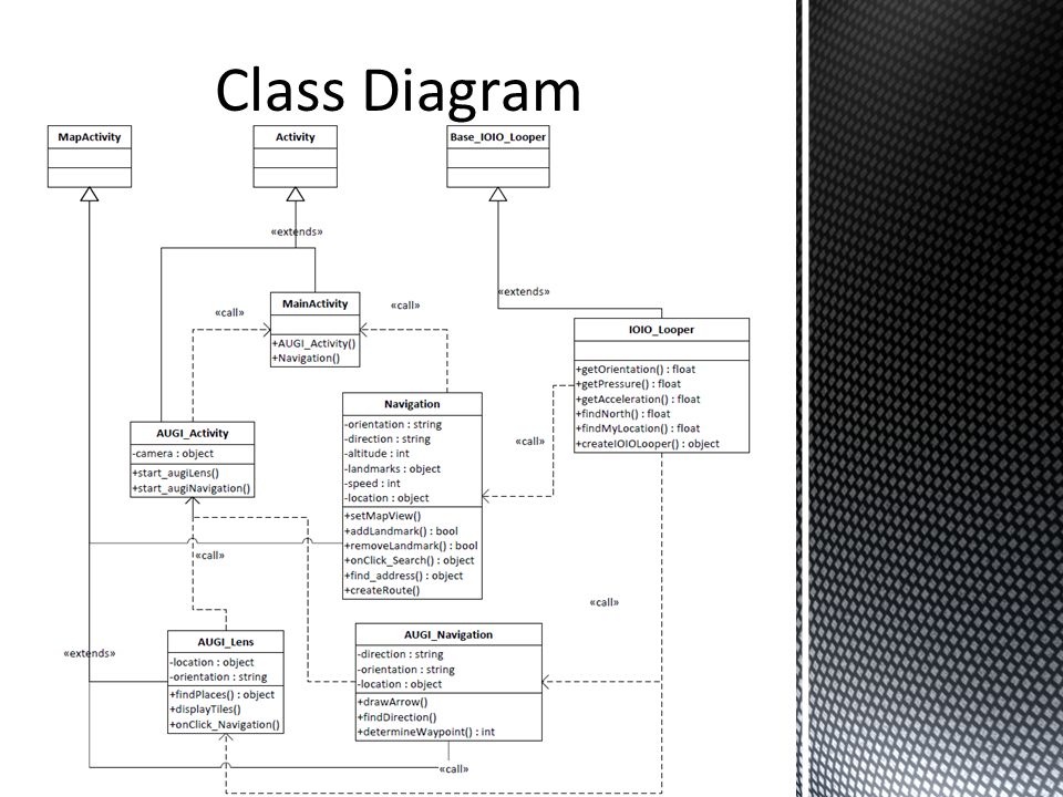
2 Basic parts to the Application: 1.Navigation Activity Basic Google Maps functionality Some custom functionality 2.AUGI Lens Activity Augmented Landmark detection Augmented Navigation

8
Basic Google Maps GPS based functionality: Landmark Searching Destination Routing Zooming and panning Added functionality: Custom landmark creation (locally stored) Bounded by UCF’s campus limits Sensor Polling: GPS (location)
 Bounded by UCF’s campus limits Sensor Polling: GPS (location)")
9
Augmented Landmark Layer: Going to detect, in real time, the landmarks that you are facing using the camera preview. Ability to detect landmarks through obstruction and display name preview. If a landmark is selected, Augmented navigation will initiate. Sensor Polling: GPS (location) Gyroscope (orientation) Magnetometer (find North)
 Gyroscope (orientation) Magnetometer (find North).")
10
Augmented Navigation Layer: Initiated within AUGI Lens activity User will be navigated to selected landmark via augmented on-screen route lines. Sensor polling: GPS sensor(location) Magnetometer (find North) Gyroscope (orientation) Barometric sensor (altitude)
 Magnetometer (find North) Gyroscope (orientation) Barometric sensor (altitude).")
12
Java code Libraries integrate with Eclipse Plug and Play Android Driver I2C Communication Protocol Sensor Loop Class

13
Establish Connection Data Packet Format

14
Send, Receive, Process

15
Custom Board

16
MSP430 Advantages: CHEAP Arduino: Advantages: WELL DOCUMENTED Parallax Propeller: Advantages: EIGHT PROCESSERS(COGS )
")
17
Provides robust connectivity to an Andriod device via a USB/bluetooth connection. Fully controllable from within an Android application using a simple and intuitive Java API Talks to the PandaBoard ES via USB Directly!

18
Based on PIC24 Chipset with 48 pins Analog input/output Digital input/output((3.3v or 5v open drain mode) I2C (3 module), UART, SPI Supplies 3.3v and 5V
 I2C (3 module), UART, SPI Supplies 3.3v and 5V")
19
PandaBoard ES GPS Magnetometer Barometer IMU USB 3.3v Battery I2C clock GND I2C data UART TX UART RX

20
Pandaboard ES 5v IOIO Board 5 – 15v

21
Polymer Lithium Ion Battery Output: 3.7v 6000mAh (Long Battery Life)
")
22
Input: 1 – 4 v Output: 5v or 3.3v Max Current: 200 mA.

23
Polymer Lithium Ion Battery 3.7v, 6000mAh Battery Charger 3.7v 5v Step-up 1-4v to 5v IOIO Board PandaBoard ES START HERE

24
Features: Up to 20Hz update rate -165dBm tracking sensitivity 3.5 second TTFF with AGPS 1 second hot start 2.5m accuracy Multipath detection and suppression Jamming detection and mitigation 67mW full power navigation Works directly with active or passive antenna Single 2.7-3.3V supply

25
Features: Gain 26dB VSWR <2.0 Voltage 3.3V +/- 0.5V Current 12mA Weight 18g

26
Features: Digital two wire (I²C, TWI, "Wire") interface Wide barometric pressure range Flexible supply voltage range (1.8V to 3.6V) Ultra-low power consumption Low noise measurements Factory-calibrated Includes temperature sensor Low-profile with a small footprint
 interface Wide barometric pressure range Flexible supply voltage range (1.8V to 3.6V) Ultra-low power consumption Low noise measurements Factory-calibrated Includes temperature sensor Low-profile with a small footprint")
27
Features: I2C Interface Input Voltage: 2.3 - 3.4V Tri-Axis angular rate sensor (gyro) with full scale range ±250dpi to ±2000dpi Tri-Axis accelerometer with a programmable full scale range of ±2g, ±4g, ±8g and ±16g Digital Motion Processing™ (DMP™) engine offloads complex MotionFusion, sensor timing synchronization and gesture detection Embedded algorithms for run-time bias and compass calibration. No user intervention required

28
Features: Simple I2C interface 2.16-3.6VDC supply range Low current draw 5 milli-gauss resolution

29
U.S. Army Simulation and Training Technology Center: DARPA Cell ItemCost Panda Board ES $162 Panda Expansion Board $250 5MP Camera + Adapter $100 IOIO Board$50 CY8CKIT PSOC $100 Propeller Chip $8 Step-Up$6 GPS + Antenna $62 Sensors$80 Battery$40 Shipping$54 Total$912 Total Allotted Budget: $2,000 Expenses to date: $912

30
Group MemberProject Task Jonathan Pedrosa : BSPE Primary: Sensor Board Software Interface Secondary: Augi Application Development, Tablet Housing Adam Ilter : BSPEPrimary: Augi Application Development Secondary: Sensor Board Software Phillip Lee : BSEEPrimary: Sensor Board Circuit Design and Manufacture Secondary: Sensor Integration with IOIO Zulkafil Ahamed : BSEEPrimary: Sensor Integration with IOIO Secondary: Sensor Board Circuit Design Application Sensor Writing Software 25% Sensor Project Board Total 50% 33% February 22, 2013

Similar presentations