Download presentation
Presentation is loading. Please wait.

4
Precipitation = water that falls from a cloud, forms due to condensation of water vapor Condensation also forms fog on the ground Ex: Rain, snow, sleet, hail, drizzle Water Vapor = gaseous form of water, forms due to evaporation

5
Warm air can hold more moisture (water vapor) than colder air this is why it is always more humid in the summer than in the winter AND why the air is so dry in the winter
 than colder air this is why it is always more humid in the summer than in the winter AND why the air is so dry in the winter")
6
Relative Humidity is the ratio of the actual amount of water vapor in the air compared to the total amount of water vapor the air can possibly hold at that temperature EX: 90% humidity means that the air is 90% full of water vapor

7
Humidity is measured using a hygrometer (specific type = Psychrometer) - 2 thermometer (one wet and one dry) & temperatures are compared - The larger the difference in temperatures between the 2, the lower the relative humidity
 - 2 thermometer (one wet and one dry) & temperatures are compared - The larger the difference in temperatures between the 2, the lower the relative humidity")
8
At night, if temperatures reach at or below the dew point then condensation of water vapor occurs and dew forms on your grass the next morning Dew point temperature is determined by humidity level: Higher dew point temperatures indicate moist/humid air Lower dew point temperatures indicate dry air.

10
= Must have saturated air (full of water vapor) that is cooled to its dew point, AND the water vapor must have something to condense around = Condensation Nuclei (includes dust, smoke, and salt from sea spray
 that is cooled to its dew point, AND the water vapor must have something to condense around = Condensation Nuclei (includes dust, smoke, and salt from sea spray")
11
Fog

12
At night, surface radiates heat causing the adjacent air to cool rapidly = forms dew and fog Clouds usually form during the warmest part of the day when air rises & expands, causing it to cool and condense

13
When air expands, it cools When air is compressed, it warms When air rises, it decreases in pressure causing it to expand = cooling When air descends (sinks), it increases in atmospheric pressure causing it to compress = warming Strange Clouds
, it increases in atmospheric pressure causing it to compress = warming Strange Clouds")
14
4 Reasons: 1. Orographic Lifting = when elevated terrains, such as mountains, act as barriers to air flow - air is forced upward over the mts, causing cooling & condensation = clouds & rain - causes one side of mts to be very moist and other side be very dry = Rain Shadow Effect

15
2. Frontal Wedging = occurs when warm and cold air masses meet (creating a weather front) - colder/denser air acts as a barrier, so that warmer/less dense air mass has to rise above it = cooling & condensation
 - colder/denser air acts as a barrier, so that warmer/less dense air mass has to rise above it = cooling & condensation.")
16
3. Convergence = whenever air in the lower atmosphere atmosphere flows together, lifting results = cooling & condensation EX: Florida has converging winds from Gulf of Mexico & Atlantic that causes many thunderstorms to develop Convergence

17
4. Localized Convective Lifting = on warm summer days, unequal heating of Earth’s surface causes pockets of hot air (Thermals) to rise - Hand gliders & large birds of prey use thermals to soar and glide upward - Often produce mid- afternoon summer showers in Mid-West
 to rise - Hand gliders & large birds of prey use thermals to soar and glide upward - Often produce mid- afternoon summer showers in Mid-West.")
18
If air mass is the same temperature as surrounding air masses = it’s Stable = resists vertical movement

19
If air mass is at a different temperature as surrounding air masses = it’s Unstable = tends to rise vertically As long as air mass is warmer and less dense than surrounding air masses, it will continue to rise Occurs when air close to surface is significantly warmer than the air higher above it = warm air rises and colder air moves in to take its place

21
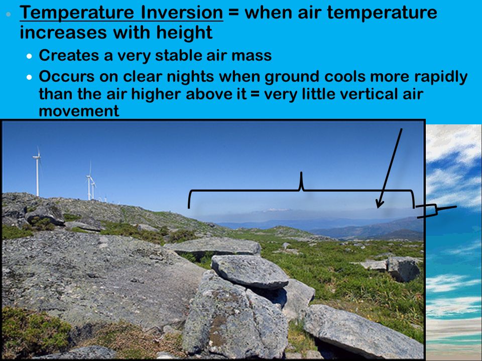
Temperature Inversion = when air temperature increases with height Creates a very stable air mass Occurs on clear nights when ground cools more rapidly than the air higher above it = very little vertical air movement

22
When stable air is forced upward by orographic lifting, frontal wedging, or convergence = clouds are widespread (cover entire sky), thin, and produce very little precipitation Creates dreary, overcast days When unstable air is lifted = clouds are towering (very tall), often generate thunderstorms, and create lots of wind overcast
, thin, and produce very little precipitation Creates dreary, overcast days When unstable air is lifted = clouds are towering (very tall), often generate thunderstorms, and create lots of wind overcast")
25
Clouds = visible moisture made of tiny droplets of water or tiny crystals of ice Classified based on their shape & height

27
1. Cirrus = high, thin, and white - usually made entirely of ice crystals - don’t create much precipitation - occur as patches, very thin sheets, or long wispy fibers that look like feathers

28
1. Cumulus = rounded individual masses - normally have flat bases and large rounded tops, similar in appearance to cauliflower

29
1. Stratus = sheet or layer shape that cover much of the sky -no individual clouds visible -Create infrequent light snow or drizzle

30
3 Levels of Clouds: 1. High Clouds = begin at altitudes of 6000 meters and above (Prefix cirro = high) - Cirrus = thin & wispy - Cirrostratus = high, flat, and layered - Cirrocumulus = small, high, fluffy masses Usually indicate stormy weather approaching
 - Cirrus = thin & wispy - Cirrostratus = high, flat, and layered - Cirrocumulus = small, high, fluffy masses Usually indicate stormy weather approaching.")
31
2. Middle Clouds = occur at heights from 2000 to 6000m Alto = middle - Altocumulus = large, rounded masses - Altostratus = create a uniform white to grayish sheet covering the sky = Overcast

32
3. Low Clouds = form at altitudes below 2000m (Prefix nimbus = rain cloud) - Stratus = low, uniform, fog-like layer of clouds, possible light precipitation - Stratocumulus = scalloped (rounded) bottom that appears as long parallel rolls or broken patches - Nimbostratus = layered rain cloud, forms from rising stable air masses
 - Stratus = low, uniform, fog-like layer of clouds, possible light precipitation - Stratocumulus = scalloped (rounded) bottom that appears as long parallel rolls or broken patches - Nimbostratus = layered rain cloud, forms from rising stable air masses.")
33
Cumulus clouds extend upwards throughout all 3 levels, are created from unstable air masses rising - Cumulonimbus = dark, massive, dangerous, thunderstorm producing = “Thunderhead”

34
- no difference physically from clouds except in the way it is formed: 1. Fogs caused by Cooling = occurs when warm, moist air from the ocean moves over cold ocean waters and is blown onshore OR can form on cool, clear nights when the Earth’s surface cools rapidly by radiation (thin layer of air near ground is cooled below its dew point), accumulates in low lying areas Causes the dense fogs of London, Seattle etc…
, accumulates in low lying areas Causes the dense fogs of London, Seattle etc….")
35
2. Fogs caused by Evaporation = when cold air moves warm water, moisture evaporates to saturate air, then air meets cooler air mass, causing it to condense Fogs form over water (steamy appearance) usually in fall or early winter
 usually in fall or early winter.")
36
= Cloud droplets collide and combine to grow in volume to get 1,000,000 times bigger to form 1 rain drop

37
1. Snow = ice crystals - occurs when cloud temperature is - 40ºC - surface temperature must be below 4ºC for snow to stick - most rain drops actually start out as snow but melt into rain before they reach the ground

38
1. Rain = drops of water that are at least 0.5 mm in diameter

39
3. Sleet = small particles of ice - occurs when rain falls through a layer of freezing air

40
4. Glaze = when raindrops are super-cooled (below 0ºC) and turn to ice when they impact the ground
 and turn to ice when they impact the ground")
41
5. Hail = begin as small ice pellets that grow within cumulonimbus cloud updrafts (strong upward winds) - increase in size as they circulate within the cloud by forming layers of ice
 - increase in size as they circulate within the cloud by forming layers of ice.")
43
Pg 527 - 528 # 1, 3, 4, 6, 7, 8, 10 = write out question and answer # 11, 13, 17, 19, 22 = answer the questions in complete sentences Vocabulary Words Cirrus Condensation Condensation NucleiCumulus Dew Point Front HailHumidity Hygrometer Nimbus Orographic Lifting Stratus Temperature Inversion

Similar presentations


 – The movement of water between.>")


