Download presentation
Presentation is loading. Please wait.

1
Navigation – terms & equipment

2
Objectives Define navigation Discuss the differences between latitude and longitude Convert latitude & longitude from one format to another List 3 navigation aids and explain their functions Choose the appropriate radio for various situations

3
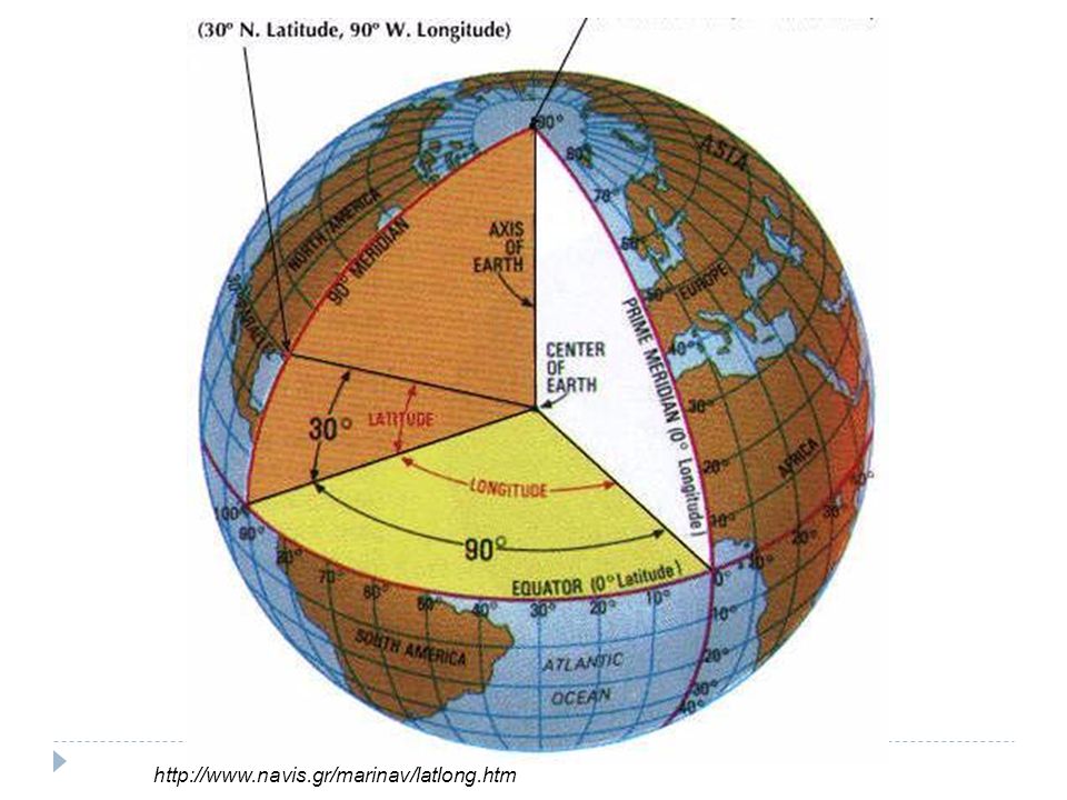
Background Geographic structure of the earth Lines of latitude

4
http://www.navis.gr/marinav/latlong.htm

5
Background Geographic structure of the earth Lines of latitude Lines of longitude

6
http://www.navis.gr/marinav/latlong.htm
7
Background Geographic structure of the earth Lines of latitude Lines of longitude Nautical measurements 1 degree = 60 minutes (‘) & 1 minute = 60 seconds (“) Distance & speeds 1 nmi = 1,852 meters 1 knot = 1 nmi / hour
 & 1 minute = 60 seconds ( ) Distance & speeds 1 nmi = 1,852 meters 1 knot = 1 nmi / hour")
8
Navigation terms Chart – map; reproduction of the earths surface in 2D Bearing - The direction (degrees) of an object expressed either as a true bearing as shown on the chart, or as a bearing relative to the heading of the boat Course – direction vessel is being steered Current – horizontal movement of water
 of an object expressed either as a true bearing as shown on the chart, or as a bearing relative to the heading of the boat Course – direction vessel is being steered Current – horizontal movement of water")
9
Navigation Bridge equipment Compass http://www.nauticexpo.com

10
Navigation Bridge equipment Compass GPS / Plotters Images from http://www.maptechnavigation.com/

11
GPS - formats Output in multiple formats – be aware of the settings before writing down coordinates on your forms degrees, minutes, seconds- N 03°25’30” degrees, minutes and 10ths of minutes- N 03°25.5’ decimal degrees- N 03.425° Converting Degrees, minutes, second >>> degrees, minutes &10ths of minutes Divide seconds by 60 and add to minutes Decimal degrees >>> degrees, minutes &10ths of minutes Multiply the decimal value by 60

12
Navigation Bridge equipment Compass GPS / Plotters Radar Images from http://fis.com/

13
Navigation Bridge equipment Compass GPS / Plotters Radar Sonar / Echo sounder Images from C. Heineken, CapFish

14
Navigation Bridge equipment Compass GPS / Plotters Radar Sonar / Echo sounder Communications Mobile phone – satellite, cell Radios Images from http://www.satellitephonestore.com/

15
Navigation Bridge equipment Compass GPS / Plotters Radar Sonar / Echo sounder Communications Mobile phone – satellite, cell Radios VHF: http://www.nauticexpo.com SSB: http://www.davesmarineelectronics.com/

16
Radios - VHF Very High Frequency International Distress Channel – 16 Transmission distance ~line of sight Image: USCG Auxiliary 2007

17
Radios - SSB Single Side Band International Distress Channel – 2183 kHz Transmission medium to long distances SSB: http://www.davesmarineelectronics.com/

18
Radios – How to use One-way transmission Public - be mindful of what you say Speak slowly & distinctly into the microphone Switch to working channel if initial contact is on emergency channel/frequency Short & concise

19
Radios – General procedure Verify power & appropriate channel Verify not in use Adjust squelch Depress microphone button & call the vessel or group you are trying to contact 3x followed by your vessel name, call sign & station you’re calling on Wait 2 minute before trying again. Switch to working channel Use terms like “over” and “copy” when you are done speaking or understand When finished, end call with vessel name, call sign and the word “out”

20
Summary What is navigation? What are the differences between latitude and longitude? How many minutes are in a degree of latitude? How about longitude? List 3 navigation aids and explain their functions Which radio would you use to call a vessel that you can see? Which radio would you use to call the observer program 100 nmi away? Homework – conversion practice

21
References United States Coast Guard Auxiliary. 2007. Boating Skills and Seamanship, 13th Edition. International Marine / McGraw-Hill, Camden, ME. Thank you to Chris Heineken, Capricorn Fisheries (CapFish), Cape Town South Africa for sharing his observer training materials. Calder, N. 2003. How to Read a Nautical Chart. International Marine / McGraw-Hill, Camden, ME.
, Cape Town South Africa for sharing his observer training materials. Calder, N How to Read a Nautical Chart. International Marine / McGraw-Hill, Camden, ME..")
Similar presentations


 O-0205 LOCATE A POINT ON A MAP USING THE CAP GRID SYSTEM (S) O-2003 GRID.>")


