Download presentation
Presentation is loading. Please wait.

1
Accuracy and Maps Mike Ritchie, PE, PLS, PSM, CP President and CEO Photo Science

2
Horizontal Accuracy As indicated in the National Standard for Spatial Data Accuracy (NSSDA): “Horizontal accuracy shall be tested by comparing the planimetric coordinates of well-defined points in the dataset with coordinates of the same points from an independent source of higher accuracy.
: Horizontal accuracy shall be tested by comparing the planimetric coordinates of well-defined points in the dataset with coordinates of the same points from an independent source of higher accuracy.")
3
Vertical Accuracy Vertical accuracy shall be tested by comparing the elevations in the dataset with elevations of the same points as determined from an independent source of higher accuracy

4
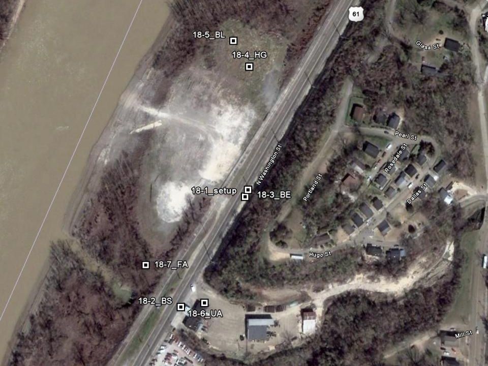
Well Defined Points A well-defined point represents a feature for which the horizontal position is known to a high degree of accuracy and position with respect to the geodetic datum. For the purpose of accuracy testing, well- defined points must be easily visible or recoverable on the ground, on the independent source of higher accuracy, and on the product itself.

5
Comparing & Extracting Elevations Consistent with best practices, Triangulated Irregular Networks (TINs) of elevation datasets are interpolated at the horizontal coordinates of vertical check points in order to interpolate elevations at those coordinates for the dataset being tested.
 of elevation datasets are interpolated at the horizontal coordinates of vertical check points in order to interpolate elevations at those coordinates for the dataset being tested.")
6
Accuracy at 95% The ASPRS horizontal accuracy standard is based on accuracy classes using root-mean- square-error (RMSE) statistics, whereas the ASPRS vertical accuracy standard is based on accuracy classes using RMSE statistics in non-vegetated terrain, and 95 th percentile statistics in vegetated terrain
 statistics, whereas the ASPRS vertical accuracy standard is based on accuracy classes using RMSE statistics in non-vegetated terrain, and 95 th percentile statistics in vegetated terrain")
7
Taking a Step Back Root Mean Square Error (RMSE) Statistical calculation equivalent to the square root of the mean (or average) of the individual errors squared ReportedMeasuredDeltaDelta 2 1001011 15014911 170172-24 Average =2 RMSE =1.41
 Statistical calculation equivalent to the square root of the mean (or average) of the individual errors squared ReportedMeasuredDeltaDelta Average =2 RMSE =1.41")
8
Meaning… It is important to understand the difference between the 95% confidence interval and 95 th percentile error Horizontal Error – 95% Confidence Interval –Assumes normal distribution of the errors –= RMSEr x 1.7308 Fundamental Vertical Accuracy – 95% C.I. –Assumes normal distribution of the errors –=RMSEz x 1.96

9
Meaning… Supplemental Vertical Accuracy is Different –Includes: Urban areas; High grass, weeds, and crops; Brush lands and low trees; Forested, fully covered by trees; Sawgrass; and Mangrove –Assumption is that the data is not normally distributed – there can be biases in the data –SVA is based on 95 th percentile error (not C.I.) –Basically, line up absolute value of the errors
 –Basically, line up absolute value of the errors")
10
Vertical Accuracy… Statistically, in non-vegetated terrain and elsewhere when elevation errors follow a normal distribution, 68.27% of errors are within one standard deviation (σ) of the mean error, 95.45% of errors are within 2σ of the mean error, and 99.73% of errors are within 3σ of the mean error. The formula 1.96 is used to approximate the maximum error either side of the mean that applies to 95% of the values

11
ASPRS Draft Accuracy Standards Vertical Data Accuracy Class RMSEz in Non- Vegetated Terrain (cm) Non-Vegetated Vertical Accuracy (NVA) at 95% Confidence Level (cm) Vegetated Vertical Accuracy (VVA) at 95 th Percentile (cm) Lidar Relative Accuracy Swath-to- Swath in Non- Vegetated Terrain (RMSDz/Max Diff) (cm) I1.02.03.00.8/1.6 II2.55.07.52.0/4.0 III5.010.015.04.0/8.0 IV10.020.030.08.0/16.0 V12.525.037.510.0/20.0 VI20.040.060.016.0/32.0 VII33.366.7100.026.7/53.3 VIII66.7133.3200.053.3/106.6 IX100.0200.0300.080.0/160.0 X333.3666.71000.0266.6/533.4
 Non-Vegetated Vertical Accuracy (NVA) at 95% Confidence Level (cm) Vegetated Vertical Accuracy (VVA) at 95 th Percentile (cm) Lidar Relative Accuracy Swath-to- Swath in Non- Vegetated Terrain (RMSDz/Max Diff) (cm) I /1.6 II /4.0 III /8.0 IV /16.0 V /20.0 VI /32.0 VII /53.3 VIII /106.6 IX /160.0 X /533.4")
12
ASPRS Draft Accuracy Standards Vertical Data Accuracy Class RMSEz in Non- Vegetated Terrain (cm) Non-Vegetated Vertical Accuracy (NVA) at 95% Confidence Level (cm) Vegetated Vertical Accuracy (VVA) at 95 th Percentile (cm) Appropriate Contour Interval supported by the RMSEz value Recommended Minimum Nominal Pulse Density (pts/m 2 )/ Maximum Nominal Pulse Spacing (meters) I1.02.03.03 cm ≥20/0.224 II2.55.07.57.5 cm 16/0.250 III5.010.015.015 cm (~6”)8/0.354 IV10.020.030.030 cm (~1’)2/0.707 V12.525.037.537.5 cm1/1.000 VI20.040.060.060 cm (~2’)0.5/1.414 VII33.366.7100.01-meter0.25/2.000 VIII66.7133.3200.02-meter0.1/3.162 IX100.0200.0300.03-meter0.05/4.472 X333.3666.71000.010-meter0.01/10.000
 Non-Vegetated Vertical Accuracy (NVA) at 95% Confidence Level (cm) Vegetated Vertical Accuracy (VVA) at 95 th Percentile (cm) Appropriate Contour Interval supported by the RMSEz value Recommended Minimum Nominal Pulse Density (pts/m 2 )/ Maximum Nominal Pulse Spacing (meters) I cm ≥20/0.224 II cm 16/0.250 III cm (~6 )8/0.354 IV cm (~1’)2/0.707 V cm1/1.000 VI cm (~2’)0.5/1.414 VII meter0.25/2.000 VIII meter0.1/3.162 IX meter0.05/4.472 X meter0.01/10.000")
13
ASPRS Draft Accuracy Standards Project Area (Sq. Miles) Horizontal Testing Vertical Testing (not clearly-defined points) Total Number of Static Horizontal Check Points (clearly-defined points) Number of Static Vertical Check Points in NVA Number of Static Vertical Check Points in VVA Total Number of Static Vertical Check Points ≤ 20020 0 201 – 30025201030 301 – 40030251540 401 – 50035302050 501 – 60040352560 601 – 70045403070 701 – 80050453580 801 – 90055504090 901 – 1000605545100
 Horizontal Testing Vertical Testing (not clearly-defined points) Total Number of Static Horizontal Check Points (clearly-defined points) Number of Static Vertical Check Points in NVA Number of Static Vertical Check Points in VVA Total Number of Static Vertical Check Points ≤ – – – – – – – –")
22
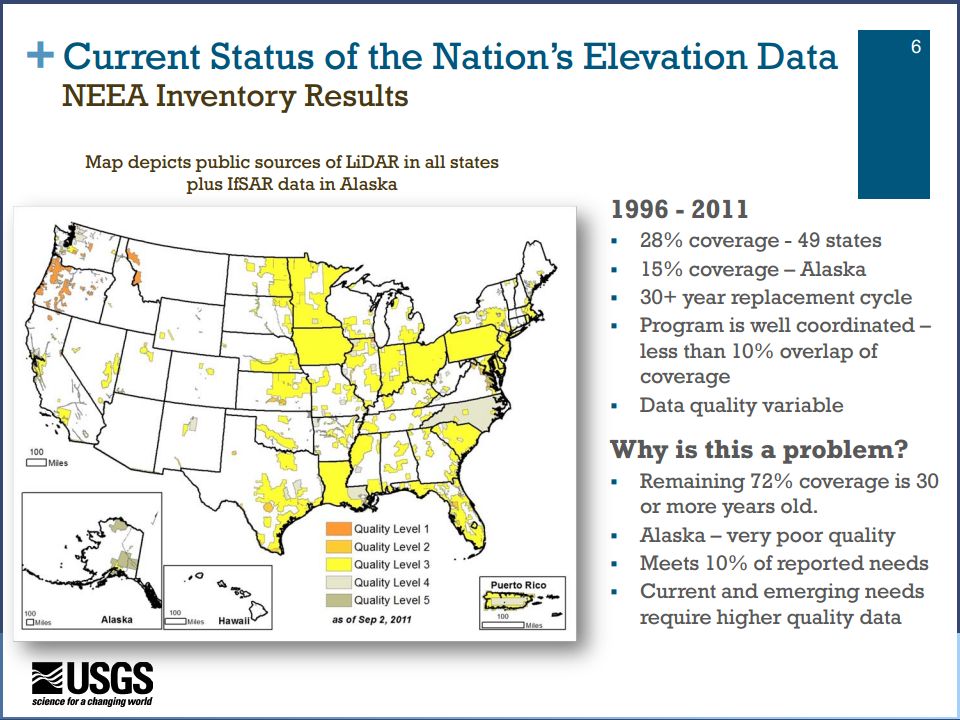
3D Elevation Program Initiative known as 3DEP National Enhanced Elevation Assessment (NEEA) was completed in 2011 NEEA identified significant need for better elevation data Recommended by the National Digital Elevation Program and its 12 Federal member agencies
 was completed in 2011 NEEA identified significant need for better elevation data Recommended by the National Digital Elevation Program and its 12 Federal member agencies")
23
3DEP Recommended by the National Digital Elevation Program and its 12 Federal member agencies Endorsed by the National States Geographic Information Council (NSGIC) and the national Geospatial Advisory Committee (NGAC)
 and the national Geospatial Advisory Committee (NGAC)")
27
Accuracy Levels within 3DEP Based on Quality Levels QL10.35 m Posting & 9.25 cm RMSEz »8 ppsm QL 20.7 m Posting & 9.25 cm RMSEz »2 ppsm QL 31-2 m Posting & <18.5 cm RMSEz Think of 9.25 cm RMSEz as appropriate for generation of 1 foot contours, with 18.5 appropriate for 2 foot contours

Similar presentations


 Surveys>")
 2004 Brooks/Cole, a division of Thomson Learning, Inc. Chapter 9 Inferences Based on Two Samples.>")

 University of Louisiana at Lafayette 3D Surface Localization.>")
 Dr. Qassim Abdullah (Woolpert) Hans Karl.>")

>")


 NGAC Meeting September 5, 2013 The National Map.>")


