Download presentation
Presentation is loading. Please wait.

1
Improving NGS Products NGS Fall Convocation Holiday Inn – Silver Spring, MD. October 24-28, 2005 Earl F. Burkholder, PS, PE New Mexico State University Las Cruces, NM 88003

2
Overview outline - 1 Introduction Mission of NGS History of interaction with NGS Current status: technology, profession Current projects at NMSU Spatial data arena

3
Overview outline - 2 Relating NGS mission, spatial data arena NGS products and services include Forward looking opportunities Assumptions/consequences Thank you Questions/discussion

4
Introduction - EFB BS Univ. of Michigan 1973 5 years at Commonwealth Associates MS Purdue Univ. 1980 1980-1993 teach at Oregon Tech. Self employed for 5 years At NMSU since 1998 On sabbatical, writing book on 3-D

5
Mission of NGS As stated on web site: “Deliver and evolve the Nation’s foundation of reference for latitude, longitude, height, velocity, (and other things)...” Embraced by all team members? Challenge for management is to establish policies and provide leadership that minimizes default sabotage.

6
History of interaction with NGS At Commonwealth, I used NGS control. Oregon Tech, we got NGS support. Input from NGS for SEWRPC reports. At NMSU, work with Advisor Bill Stone. As ASCE Journal Editor, I relied upon NGS for reviews and articles. Now I’m promoting use of the GSDM.

7
Status of Science/Profession - 1 Science/instrumentation, digital and 3-D. Surveying profession – who are the players? - ACSM, diversity and reorganization. - ASCE, focus on engineering applications. - ASPRS, imaging & spatial info society. - FIG, international voice for surveying prof’n. - GITA, represents spatial data users. - IAG, international voice for geodesy.

8
Status of Science/Profession - 2 Surveying program at NMSU: - Started in 1990 by Dr. James P. Reilly. - Three faculty; Frank, Wurm, Burkholder. - Undergrad only, about 40 students. - Graduates get good jobs; NM & elsewhere - BLM support is vital. NMSU looking for more. - Vendors have been very good to program. (Leica loaned us $240K equipment for a year)
.")
9
Status of Science/Profession - 3 Work being done by NGS: - Readjusting the spatial network. - Supporting height modernization. - Coordinating use of CORS. - Refining services available using OPUS. - Outreach through state advisors. - Many others

10
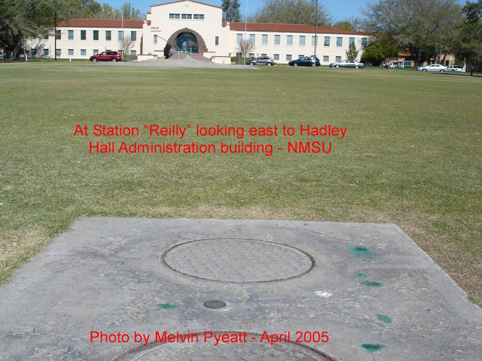
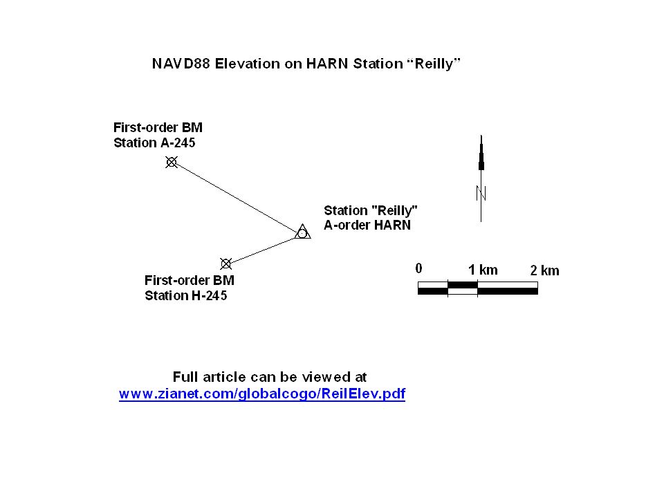
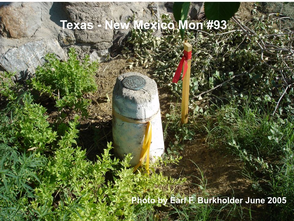
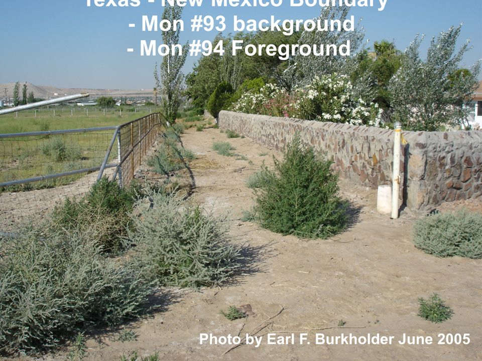
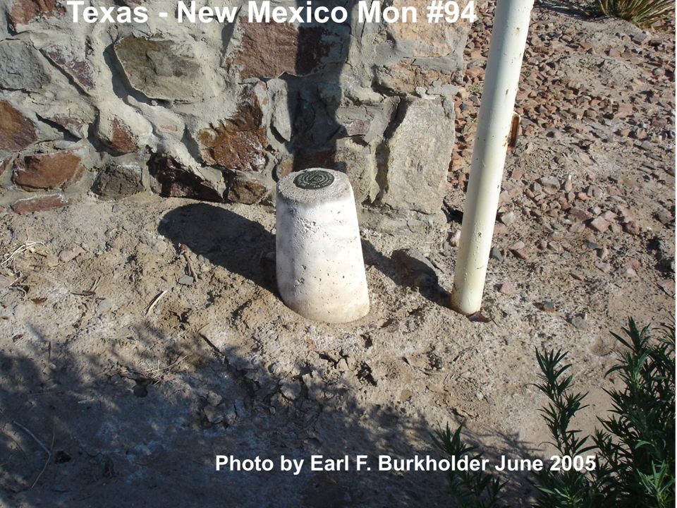
3-D Projects at NMSU NMSU GPS HARN-based network (illustrates network & local accuracy). NAVD88 elevation on HARN Station “Reilly” from nearby first-order BMs. Support of Texas/NM GPS survey of boundary defined by Rio Grande River

14
Rio Grande River Boundary Area

15
State Boundary Example State boundary between NM and Texas follows Rio Grande River for 25 miles. River meanders but boundary was “fixed” by U.S. Supreme Court in 1930 on basis of 1929 survey reconstructing 1852 lines. 105 monuments set in distance of 25 miles. Current project is to GPS the line. Horizontal record data are NAD27, Vertical data are NGVD29 (mean sea level).
..")
20
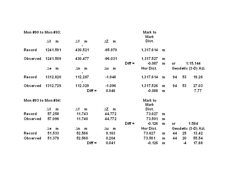
What About Record Accuracy? Supreme Court Report values: - Horizontal given to.001 seconds (0.03 m) - Vertical given to 0.001 feet (0.0003 m) Use those as standard deviations Input into BURKORD9 Inverse between points for: - Distance = 73.627 m +/- 0.042 m - Azimuth = 44-25-13.42 +/- 118.9 sec.
 - Vertical given to feet ( m) Use those as standard deviations Input into BURKORD9 Inverse between points for: - Distance = m +/ m - Azimuth = / sec..")
21
Spatial Data Arena is Huge ASPRS 10 yr forecast for remote sensing. ASPRS Panel Report to USGS on National Orthoimagery Program – comments due by October 24, 2005. see www.zianet.com/globalcogo/asprs- comments.pdf www.zianet.com/globalcogo/asprs- comments.pdf Global Spatial Data Infrastructure (GSDI) purpose is international cooperation and collaboration.
 purpose is international cooperation and collaboration..")
22
Relate NGS Mission to Arena Define and support National Spatial Reference System. Develop and promote standards. Clearing house for implementation of new technology.

23
NGS Services/Products Include CORS – 3D positions and velocities. OPUS – Automated processing for users. Height Modernization – geoid modeling. Standards – Network and local accuracy. Outreach to: - Other federal agencies - State and local agencies - Professional organizations

24
Forward Looking Opportunity - 1 Height – If data from all satellites are used on a deformable Earth, then vertical may turn out to be the strongest component. - Involves interpolation in radial direction. - Requires simultaneous data from all GPS satellites to worldwide network. - GSDM provides appropriate computational environment to do it.

25
Forward Looking Opportunity - 2 Ellipsoid height is adopted as elevation. - Reduces the need for geoid modeling. - Hydraulic head is not given by orthometric heights. - Use time analogy with local noon. ACSM articles on heights. www.zianet.com/globalcogo/elevgsdm.pdf

26
Forward Looking Opportunity - 3 Orthophoto map is produced by plotting local differences with respect to origin selected by the user. - Presumes each pixel has ECEF coordinates and covariance. - That means raster file is converted to a vector file? - Totally impractical due to storage req’d?

28
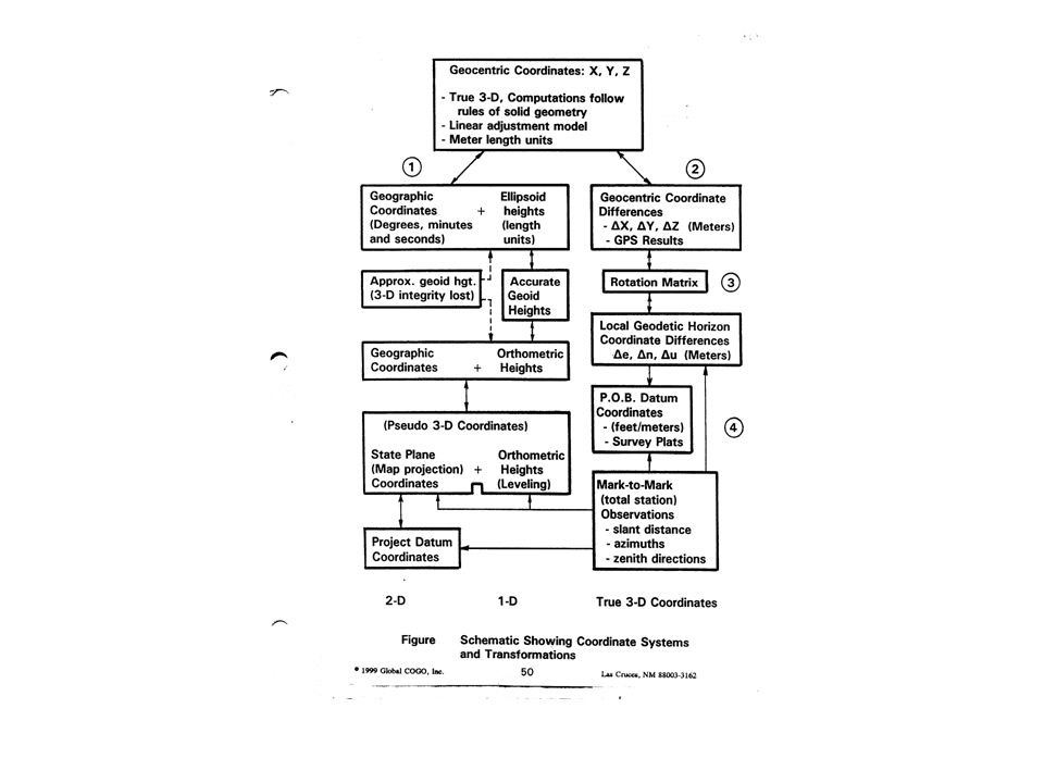
Assumptions Spatial data are digital and 3-D. There must be a single origin for 3-D data. ECEF geocentric system is foundation. Spatial data are obtained from physical observations reduced to components. Strict hierarchy for primary/derived data. Spatial data accuracy is given by standard deviations – component by component.

29
Consequences Need to make distinction between measurement and observation. Need to understand and honor difference between direct & indirect measurements. Some spatial data are relative and some are absolute. It makes a difference. Local & network accuracy are both legitimate. Local accuracy is based upon storing and using correlation.

30
Thank you! Truly grateful for opportunity to share. Sabbatical is going well. Lots yet to do. Windows-based BURKORD™ software is coming along. Will be gratis with book. Publisher not yet chosen. Back in classroom August 2006. www.zianet.com/globalcogo/status.html.www.zianet.com/globalcogo/status.html

Similar presentations


, and GEOID 12 in Alabama Overview of Height Modernization Project Overview of Height Modernization.>")


 and the Defense Mapping School Reviewed by:____________ Date:_________ Objective:>")


 Mapping Re-visited by: Earl F. Burkholder, PS, PE, F.ASCE Global COGO, Inc. – Las Cruces, NM 88003 URL:>")


