Download presentation
Presentation is loading. Please wait.

1
Wyn Cudlip BNSC/QinetiQ Lorant Czaran UN Presentation to WGISS25 China, February 2007 Global Datasets Task Team

2
CEOS WGISS 25 Meeting, China, February, 2008 Global Datasets TT Aims To encourage and support the creation of global datasets through the co-operation of CEOS members Past successes include global avhrr maps and global 1km dem Supported the distribution of the Global Landsat datasets for 1990 and 2000 to UN and others. More recently, obtained access to global coastline dataset derived from the ortho- rectified Landsat images. (Related to development of ICEDS data server and Guidelines Document in EODP TT). Currently working on a plan to create a global 30m DEM in collaboration with WGCV and GEOSS. Note: –EO Data Portal TT (now closed) concerned with providing interoperable access to global EO datasets. –Global Datasets TT concerned with creation of global datasets.
. Currently working on a plan to create a global 30m DEM in collaboration with WGCV and GEOSS. Note: –EO Data Portal TT (now closed) concerned with providing interoperable access to global EO datasets. –Global Datasets TT concerned with creation of global datasets..")
3
CEOS WGISS 25 Meeting, China, February, 2008 Initiatives of Interest Global Roads Project. GEO DEM Interoperability Task DA-07-01 Global Flood Monitoring Iridium Next Constellation UN SPIDER Programme Liaison with Global Map (& ISCGM) Link to Land Surface Imaging activity?
 Link to Land Surface Imaging activity .")
4
CEOS WGISS 25 Meeting, China, February, 2008 Global Roads initiative CODATA accepted Global Roads proposal as a new working group, and it is following up on seeking funding to develop a new public dataset. The project team seeks support from imaging companies and agencies for various road detection and digitization efforts, provision of orthorectified satellite imagery for the exercise, etc. I suggested at last year's workshop at CIESIN that I will keep CEOS informed, and will pass the message on regarding the support with imagery that would be needed. Support with high res. radar from DLR or CSA would be particularly useful, for road extraction in tropical areas... Available free road data will be catalogued and evaluated, included in the database, but the aim is to have a fresh, accurate road network db in the end, so a lot of work will be required to validate available data and extract new roads from imagery and through GPS tracking.... See information about the CODATA group under http://www.codata.org/taskgroups/WGglobalroads/index.html UN is represented as a Co-chair in that group, and the team uses a UN-developed Transportation model for building the new database.

5
CEOS WGISS 25 Meeting, China, February, 2008 Global 30m DEM Prof. Peter Muller provided presentation on this topic at joint WGISS/WGCV Session. Lorant Czaran is proud to be listed as a co-lead of the Task, and has been working to raise awareness and advocate for the initiative. The availability of a globally consistent 30m DEM for the UN operations is important, and UN has offered to help validate or verify the new JAXA/NASA product announced, if it becomes reality...

6
CEOS WGISS 25 Meeting, China, February, 2008 Global Flood monitoring as mentioned in Germany too (WGISS24), for the humanitarian community (UN and non-UN actors alike) the climate change-related disasters are becoming a significant issue, and UN are looking at different ways to faster predict affected areas, populations etc. The idea to develop online access to imagery catalogues and services to extract flooded areas polygons for example is very well-received, and Lorant would would like to see a GDTT role in working with other WGISS teams to develop such tools for online data extraction from sat imagery, as example... As mentioned last time the Ukrainians are developing some tools, perhaps we should try to use them with MODIS or TerraSAR data for near real-time flood monitoring.... Also, the idea of using more TRMM data to estimate rainfall-related flooding risk, in combination with accurate DEM's, could be another pilot. In summary, looking at using collected satellite image data or satellite assets and WGISS-tested tools to improve global prediction of flood-affected areas, and indirectly of population numbers affected, near real-time...

7
CEOS WGISS 25 Meeting, China, February, 2008 Iridium-NEXT constellation on the plan of putting (environmental) sensors on all their new satellites... - something we could be following up with, to see where does their planning go, how would we access all data collected, etc. - there is a lot of push recently in certain circles to freely access CBERS and Landsat5 data for African institutions... Lorant is monitoring the talks, and is being copied on some communications between CGIAR, NASA and individuals, and try to find a link or harmonize with WGISS activities... Nothing concrete, but worth following... - At a recent visit Lorant had at the EU JRC, there was mention of a new large EU- supported project including use of satellite imagery and related applications for disaster management. Lorant is following up on details, to determine how we could link to that project, and what are the exact details.

8
CEOS WGISS 25 Meeting, China, February, 2008 UN-SPIDER programme the budget was approved by the UN General Assembly, providing funding for new staff and resources for the programme to be implemented starting in 2008; it is about space-based information for disaster management and emergency response, and it has a lot to do with satellite imagery and assets mediated to those developing countries that need it most... If WGISS is to be the satellite arm of GEO, this is an important initiative to follow, and I see it significant for the User Vice-Chairs and GDTT in general... Lorant will be liaising with the team in OOSA in Vienna regarding this new programme, to see if we find common ground... See http://www.unoosa.org/oosa/unspider/index.html

9
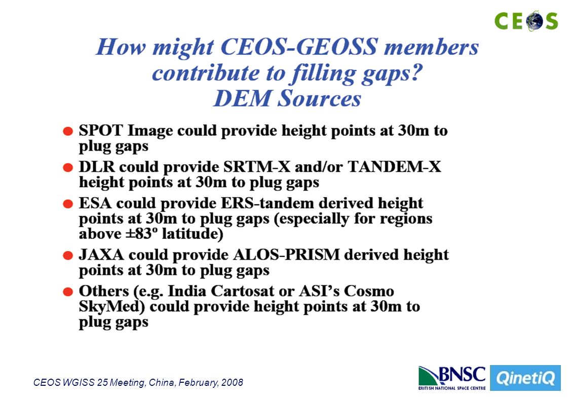
CEOS WGISS 25 Meeting, China, February, 2008 Next Generation 30m DEM Global dataset GEOSS has specified a high resolution DEM is relevant to 6 of the 9 societal benefit areas. Created GEOSS Task DA-07-01: DEM Interoperability. Now led by Prof. Jan-Peter Muller (UCL) (and Lorant Czaran) –WGCV Terrain Mapping Subgroup Leader SRTM 30m dataset has holes and only goes to 60 deg. N Plan to generate Global DEM from ASTER Data But additional activities required to fill holes and quality control etc. Could be joint activity with WGCV DEM Subgroup Several Agencies have shown interest – but no significant funding identified yet. –USGS; NGA/NASA JPL; BNSC; CNES
 (and Lorant Czaran) –WGCV Terrain Mapping Subgroup Leader SRTM 30m dataset has holes and only goes to 60 deg. N Plan to generate Global DEM from ASTER Data But additional activities required to fill holes and quality control etc. Could be joint activity with WGCV DEM Subgroup Several Agencies have shown interest – but no significant funding identified yet. –USGS; NGA/NASA JPL; BNSC; CNES.")
10
CEOS WGISS 25 Meeting, China, February, 2008

12
Summary of Actionable ACTIONs: CEOS Plenary CEOS Plenary is recommended by WGCV and WGISS to support GEOSS task DA-07- 01 through the following actions –Encourage all CEOS member space agencies who are creating global EO-DEMs to consider making these DEMs or different DEM subsets (e.g. small groups of pixels identified in ASTER GDEM as missing) publicly available through OGC-compliant servers –Encourage all CEOS member space agencies to liaise with their national mapping agency to provide DEM test sites with publicly available ground truth data for assessment of global EO- derived DEMs –Encourage each EO-DEM data supplier to provide web-GIS facilities for the reporting of Known Issues including the delineation of areas of bad data which can later be flagged as such and compared against and substituted by other datasets –Ensure that resources are made available so that all published DEM datasets can be re- processed if Known Issues identify bad data and these cannot be replaced from another source –Encourage all member agencies to develop continental-shelf bathymmetry programmes and request CEOS member agencies to encourage their relevant international and national body to make publicly available their bathymmetry heights using the mechanisms proposed for land DEM or something consistent with these principles
 publicly available through OGC-compliant servers –Encourage all CEOS member space agencies to liaise with their national mapping agency to provide DEM test sites with publicly available ground truth data for assessment of global EO- derived DEMs –Encourage each EO-DEM data supplier to provide web-GIS facilities for the reporting of Known Issues including the delineation of areas of bad data which can later be flagged as such and compared against and substituted by other datasets –Ensure that resources are made available so that all published DEM datasets can be re- processed if Known Issues identify bad data and these cannot be replaced from another source –Encourage all member agencies to develop continental-shelf bathymmetry programmes and request CEOS member agencies to encourage their relevant international and national body to make publicly available their bathymmetry heights using the mechanisms proposed for land DEM or something consistent with these principles.")
13
CEOS WGISS 25 Meeting, China, February, 2008 Summary of Actionable ACTIONs: CEOS-WGISS CEOS-WGISS is invited to contribute technology to facilitate interoperability between different global DEM datasets –To ensure that all Global/Regional DEMs are made available in OGC-compliant (WMS and WCS) formats and their URLs are easily discoverable –To agree on a common standard for the representation of WMS (e.g. ICEDS colour LUT and 30º (elevation), 330º (azimuth)) –To agree on a common standard for WCS format (e.g. geotiff) –To facilitate the filling in of gaps (or artifact identified regions) in ASTER GDEM from another dataset including how QC information is to be incorporated into the data fusion process. This procedure should be best incorporated within a Web Processing Service –To allow easy inter-comparison of different satellite-derived DEM datasets stored as WCS datasets including both publicly released versions and those stored in-house –To allow standard QA procedures to be fully automated so that when new ground truth datasets become available, existing EO-derived DEMs can be assessed –To develop Known Issues web facilities to allow users of global DEMs to report issues with the data including geospatial reporting (e.g. the following DEM pixels via this shapefile have been shown to be in error)
, 330º (azimuth)) –To agree on a common standard for WCS format (e.g. geotiff) –To facilitate the filling in of gaps (or artifact identified regions) in ASTER GDEM from another dataset including how QC information is to be incorporated into the data fusion process. This procedure should be best incorporated within a Web Processing Service –To allow easy inter-comparison of different satellite-derived DEM datasets stored as WCS datasets including both publicly released versions and those stored in-house –To allow standard QA procedures to be fully automated so that when new ground truth datasets become available, existing EO-derived DEMs can be assessed –To develop Known Issues web facilities to allow users of global DEMs to report issues with the data including geospatial reporting (e.g. the following DEM pixels via this shapefile have been shown to be in error).")
Similar presentations


 resolution data initiative,>")

 Trends & Progress in Data & Information.>")


 CEOS Disaster SBA Team Coordinator Priority Actions GEO Disaster WP 2012-2015.>")

