Download presentation
Presentation is loading. Please wait.

1
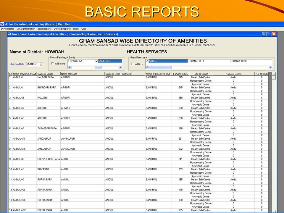
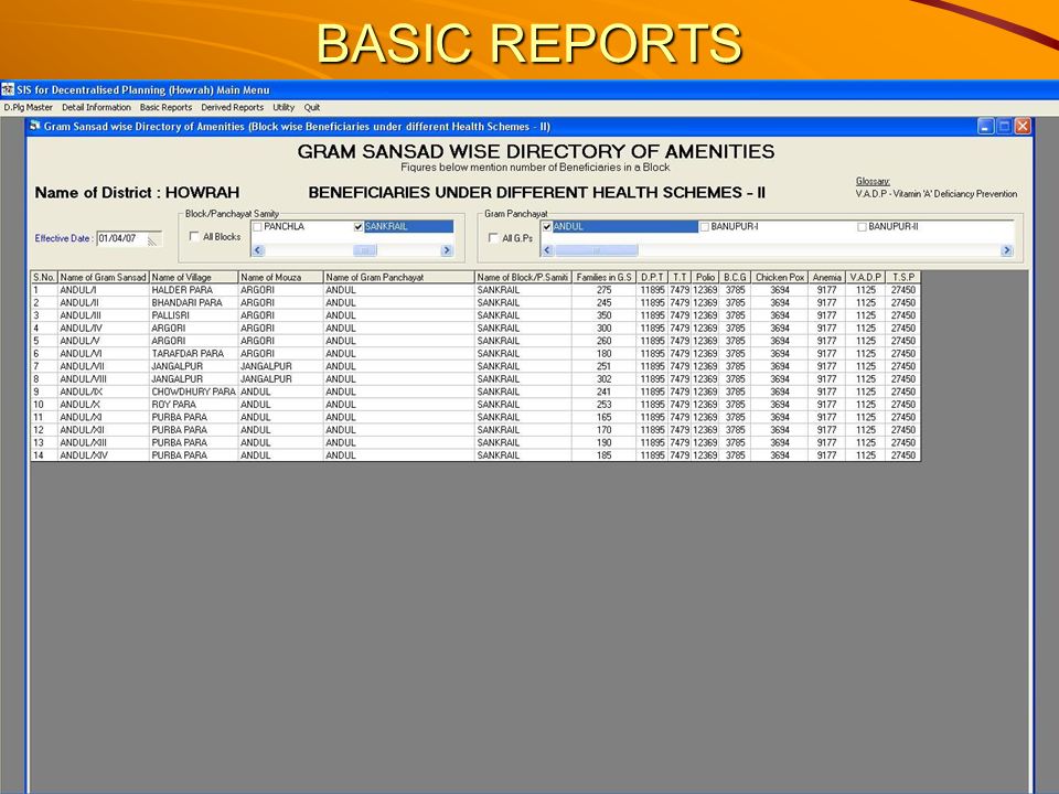
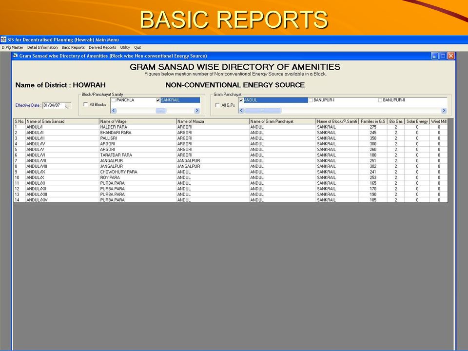
BASIC REPORTS

7
Statistical Information provided by the SIS

8
An illustrative list of activities related to decentralised planning which can make use of the previous information i) Educational Planning: Based on number of children of primary school going age, the requirement of resources like extra schools, extra school rooms and number of teachers can be determined using the criteria student–teacher ratio and maximum distance to be travelled. Existing infrastructure facilities with respect to schools can be worked out on the basis of data provided in the booklet Based on number of children of primary school going age, the requirement of resources like extra schools, extra school rooms and number of teachers can be determined using the criteria student–teacher ratio and maximum distance to be travelled. Existing infrastructure facilities with respect to schools can be worked out on the basis of data provided in the booklet The criteria can be varied and different scenarios can be developed. The criteria can be varied and different scenarios can be developed.

9
An illustrative list of activities related to decentralised planning which can make use of the previous information ii) Health facilities Planning: The criteria of accessibility, population served for different health facility types can be used to determine the number of facilities of each type (Allopathy, Ayurvedic, Homeopathy etc) to be provided to meet the norms of health care. First of all, one should compute the existing facilities and comparison can be made with the desired ones. Questions of actual location of these centres / facilities can then be decided by applying the principle of “maximal coverage location problems” with the information created. The criteria of accessibility, population served for different health facility types can be used to determine the number of facilities of each type (Allopathy, Ayurvedic, Homeopathy etc) to be provided to meet the norms of health care. First of all, one should compute the existing facilities and comparison can be made with the desired ones. Questions of actual location of these centres / facilities can then be decided by applying the principle of “maximal coverage location problems” with the information created.
 to be provided to meet the norms of health care. First of all, one should compute the existing facilities and comparison can be made with the desired ones. Questions of actual location of these centres / facilities can then be decided by applying the principle of maximal coverage location problems with the information created..")
10
An illustrative list of activities related to decentralised planning which can make use of the previous information iii) Road Network Planning: Road network can be made following criteria like Road network can be made following criteria like All Mouzas / Villages should be connected to Gram Panchayats offices by all weather roads; All Gram Panchayats / Mouzas should be connected (within a specified distance to be determined, say, within 5 miles) to a metalled road (having bus route) connecting to the Block Head Quarter; All Block Head Quarters have to be connected through the District Head Quarter through metalled road. Maps fulfilling these criteria in consultation with the user groups can be prepared and compared with the existing network to identify the additional road network to meet criteria. These criteria can be varied and alternative scenarios can be prepared. Maps fulfilling these criteria in consultation with the user groups can be prepared and compared with the existing network to identify the additional road network to meet criteria. These criteria can be varied and alternative scenarios can be prepared. One may also consider the need for converting the Kuccha Road to Pucca Road and to construct inter-village and intra-village roads. One may also consider the need for converting the Kuccha Road to Pucca Road and to construct inter-village and intra-village roads. Road network planning has spatial significance and in drawing up road network planning layout, the land to be acquired and feasibility of such acquisitions have to be ascertained. Road network planning has spatial significance and in drawing up road network planning layout, the land to be acquired and feasibility of such acquisitions have to be ascertained.

11
An illustrative list of activities related to decentralised planning which can make use of the previous information iv) Drinking Water Planning: For drinking water planning, based on the existing facility one should first try to identify those Villages / Gram Sansads which, at present, may face scarcity / insufficiency of possible drinking water. Based on identification of areas of existing scarcity, the appropriate planning should be made for provision of drinking water to those areas. Existing different sources of drinking water and the population served can be compared. For drinking water planning, based on the existing facility one should first try to identify those Villages / Gram Sansads which, at present, may face scarcity / insufficiency of possible drinking water. Based on identification of areas of existing scarcity, the appropriate planning should be made for provision of drinking water to those areas. Existing different sources of drinking water and the population served can be compared. v) Energy Planning / Rural Electrification: Spatial schemes are needed in the packages for (a) rural households without electricity, (b) rural households with partially electrified. For this, one should try to assess the extent of existing electrification and compare the share of Bio-gas units also. Spatial schemes are needed in the packages for (a) rural households without electricity, (b) rural households with partially electrified. For this, one should try to assess the extent of existing electrification and compare the share of Bio-gas units also.
 Energy Planning / Rural Electrification: Spatial schemes are needed in the packages for (a) rural households without electricity, (b) rural households with partially electrified. For this, one should try to assess the extent of existing electrification and compare the share of Bio-gas units also. Spatial schemes are needed in the packages for (a) rural households without electricity, (b) rural households with partially electrified. For this, one should try to assess the extent of existing electrification and compare the share of Bio-gas units also..")
12
An illustrative list of activities related to decentralised planning which can make use of the previous information vi) Financial Institution branch Planning; In respect of planning for financial institution branches, population served and accessibility or distance criteria should be introduced in addition to the criteria “population served per branches” alone. The distance criteria may be of 8 Km say. By applying these two criteria (population served and distance), the command area of the existing branches can be demarcated. For existing location, one may refer to the data In respect of planning for financial institution branches, population served and accessibility or distance criteria should be introduced in addition to the criteria “population served per branches” alone. The distance criteria may be of 8 Km say. By applying these two criteria (population served and distance), the command area of the existing branches can be demarcated. For existing location, one may refer to the data
, the command area of the existing branches can be demarcated. For existing location, one may refer to the data In respect of planning for financial institution branches, population served and accessibility or distance criteria should be introduced in addition to the criteria population served per branches alone. The distance criteria may be of 8 Km say. By applying these two criteria (population served and distance), the command area of the existing branches can be demarcated. For existing location, one may refer to the data.")
13
An illustrative list of activities related to decentralised planning which can make use of the previous information vii) Infrastructure Development Plans: It focuses on development of socio-infrastructure like schools, health and other amenities. It also focuses on development of such basic infrastructure like market facilities, warehousing/service centres, offices, medical, post and telegraph and internet etc. Existing facilities can be compared in terms of available maximum, minimum, average distances. It focuses on development of socio-infrastructure like schools, health and other amenities. It also focuses on development of such basic infrastructure like market facilities, warehousing/service centres, offices, medical, post and telegraph and internet etc. Existing facilities can be compared in terms of available maximum, minimum, average distances. Apart from the above sectoral planning exercise, there may be one more application area “micro-water management system”. Existing sources of water for irrigation can be identified and may be checked if they are capable of meeting the demand arising out of domestic consumption as well as of irrigation. Apart from the above sectoral planning exercise, there may be one more application area “micro-water management system”. Existing sources of water for irrigation can be identified and may be checked if they are capable of meeting the demand arising out of domestic consumption as well as of irrigation.

14
An illustrative list of activities related to decentralised planning which can make use of the previous information Another important area is Health Service Planning. One can find out the extent of medical facilities rendered to mother, children and other beneficiaries. If the services appeared to be insufficient, some planning can be made for out-reach program. One can also plan for increasing the economic activity with the farming of animals. Another important area is Health Service Planning. One can find out the extent of medical facilities rendered to mother, children and other beneficiaries. If the services appeared to be insufficient, some planning can be made for out-reach program. One can also plan for increasing the economic activity with the farming of animals. Gram Panchayat wise plan can be integrated into a plan for the Block/Panchayat Samiti with this newly developed system. Critical inputs needed for the parts of the plan have to be identified. As far as possible, efforts should be made to ensure full development of local resource potential. In fact with the proposed database, one can start even with Gram Sansad wise plans and proceed further upwards. Gram Panchayat wise plan can be integrated into a plan for the Block/Panchayat Samiti with this newly developed system. Critical inputs needed for the parts of the plan have to be identified. As far as possible, efforts should be made to ensure full development of local resource potential. In fact with the proposed database, one can start even with Gram Sansad wise plans and proceed further upwards.

15
Query based information required for making rational decision The system developed will also support ad-hoc on-line queries. It will provide speedy answers to specific queries based on the data stored in the database. It would be the stored data to provide the desired information. As illustrations, some of the queries are outlined here. The system developed will also support ad-hoc on-line queries. It will provide speedy answers to specific queries based on the data stored in the database. It would be the stored data to provide the desired information. As illustrations, some of the queries are outlined here.

16
C-1: Agriculture Proportion of land under irrigation; Ratio of irrigated to non-irrigated area; Proportion of land under different principal crops (Rice, Wheat, Cereals, Pulses and Other Oil Seeds); Rate of production of a particular principal crop per family; The most commonly practiced crop-combination; The areas with details needing urgent attention for irrigation; The number of irrigation projects (or different sources of irrigation) to be expanded for better water management in rain fed areas where assured irrigation is not possible; A query on the existence of effective market linkages supported by modern practices including post harvest management, if there be any, in case one intends to diversify agriculture into horticulture and floriculture in order to accelerate agricultural growth.
; Rate of production of a particular principal crop per family; The most commonly practiced crop-combination; The areas with details needing urgent attention for irrigation; The number of irrigation projects (or different sources of irrigation) to be expanded for better water management in rain fed areas where assured irrigation is not possible; A query on the existence of effective market linkages supported by modern practices including post harvest management, if there be any, in case one intends to diversify agriculture into horticulture and floriculture in order to accelerate agricultural growth.")
17
C-2: Animal Husbandry The live-stock and fisheries sectors together account for about 30% of the value of output of agriculture and allied sector and provide full-time and part-time employment to 5.5% of the total working population. To promote animal husbandry and fishery, one may be looking for the answers to the following queries. The live-stock and fisheries sectors together account for about 30% of the value of output of agriculture and allied sector and provide full-time and part-time employment to 5.5% of the total working population. To promote animal husbandry and fishery, one may be looking for the answers to the following queries. How many artificial insemination centres are available for promotion of appropriate cross-breeds ? What is the status of existing live-stock marketing system, if there be any at all? Number of private / Government veterinary clinics with details needing urgent attention for animal health care. The number of water bodies with details for their restoration and/or new creation for water harvesting and fishery.

18
C-3: Living Conditions Some of the queries on the living conditions may be mentioned as follows: Some of the queries on the living conditions may be mentioned as follows: Proportion of Gram Sansads with (a) fully electrified, (b) partially electrified and (c) with no electrification; (b) partially electrified and (c) with no electrification; Similar queries may be required to be addressed at the different hierarchical administrative units also; The areas (with details) needing immediate attention for electrification; The areas where non-conventional energy may be put to practice; Continued….. Continued…..

19
C-3: Living Conditions Number of Gram Panchayats with details needing urgent attention in the area of health care and drinking facilities; Number of Gram Sansads/Gram Panchayats (with the list) with lack of educational facilities needing immediate attention in establishing the educational institutions of different types; Based on the ratio of Boys to Girls at a particular level of education, how many such institutions need to be constructed and how they should be spatially accommodated in order to explore new avenues for setting up of institutions during the 11th Plan Period, and how they should be phased out within the 5 Year Plan Period; Extent and location of road network to be restored and/or newly constructed within the 11th 5 Year Plan Period.
 with lack of educational facilities needing immediate attention in establishing the educational institutions of different types; Based on the ratio of Boys to Girls at a particular level of education, how many such institutions need to be constructed and how they should be spatially accommodated in order to explore new avenues for setting up of institutions during the 11th Plan Period, and how they should be phased out within the 5 Year Plan Period; Extent and location of road network to be restored and/or newly constructed within the 11th 5 Year Plan Period.")
Similar presentations


 G.P. Singh Technical Director National Informatics Centre, Govt. of India Kendriya Bhawan.>")


 Job Creation Through.>")

![The Urban Infrastructure Challenge in Canada: Focusing on Housing Affordability and Choice Presentation by CHBA – [Name] to The Municipal Council of [Name]](/17/5358765/big_thumb.jpg "The Urban Infrastructure Challenge in Canada: Focusing on Housing Affordability and Choice Presentation by CHBA – [Name] to The Municipal Council of [Name]>")


 Conducted by The National Bureau of Statistics.>")

