Download presentation
Presentation is loading. Please wait.

1
SDJR Demonstration The following demonstration was conducted using the national instructions and MO1 tools and guidance The SDJR process is expected to evolve over time, but this is the best guidance that is currently available

2
Build an Electronic Folder Before you begin a project, create a folder for storing all project documents Supports NASIS Project object Ultimately stored on the MO1 SharePoint site to facilitate sharing of information and enhancing security Data may have to be scanned for it to be stored electronically

3
Build an Electronic Folder Includes, but not limited to: ›Spatial Distribution Maps ›Pedons OSD, TUDs, KSSL pedons, and/or other pedons ›MUD’s Original and newly proposed provisional map unit forms ›Links to KSSL Data ›Photos ›Correlation Information Correlation documents and trip reports ›University Data ›Vegetation Information ›Any other pertinent information

4
1 – Inventory and Assess Map Units In the SDJR map unit table provided ›Sort by map unit name ›Group map units based on identical or similar names ›For map units in SDJR and MLRA projects Populate project ID and project name ›For map units not in a project Populate a zero in the project ID

5
1 – Inventory and Assess Map Units MO1 recommends that you assign a project ID, project name, and priority using the map unit Excel spreadsheet We have added these three fields to the Excel spreadsheet containing your map units Feel free to develop your own methods to organize map units if these don’t work for you

6
New Fields

7
1 – Inventory and Assess Map Units Project ID ›Internal tracking tool/data management tool ›Uses a sequential alphanumeric systems ›Each project gets a unique ID ›Will help with filtering and querying ›Map units that contain the same major component (s) will receive the same number, but can be subdivided with an alpha character ›Enter zero for all non-projects This way, a blank project ID indicates that the map unit (s) was not evaluated
 will receive the same number, but can be subdivided with an alpha character ›Enter zero for all non-projects This way, a blank project ID indicates that the map unit (s) was not evaluated")
8
1 – Inventory and Assess Map Units Project Name ›Will be the name populated in the Project table in NASIS ›Proposed projects start with SDJR Example – SDJR – MLRA 2 – Alpha sandy loams, 0 to 8 percent slopes ›Future projects start with MLRA Example – MLRA – MLRA 4A – Beta loams ›Left blank for non-projects

9
1 – Inventory and Assess Map Units Project Priority ›This is your proposed project priority, Management team has the final say ›If you attempt to prioritize your projects, than you will have to decide what criteria to use Acreage and land use will be two of the most important criteria

10
Filtering ›Can use filtering to isolate similarly named map units ›Here, I have located all Alderwood consociations that generally occur in the 0 to 15 slope range 1 – Inventory and Assess Map Units

11
Can rapidly populate the Project ID and Project Name

12
Project ID Project ID = 0 ›Map unit only used in one soil survey area ›No reason to create future project at this time ›No similar map units ›Not harmonizable

13
Project ID Project ID = 1 ›Identical named map units in several survey areas ›No lower case letter suffix used since there is not a second set of Agnew map units that will be included in a project

14
Project ID Project ID’s = 2a and 2b ›Lower case letters used with 2 since there is an Alderwood project for 0 to 15 % slopes and a second project for Alderwood 15 to 30 % slopes ›You may end up grouping all Alderwood into a single project, keeping all Alderwood projects associated with the same number will make that easier to do at a later time

15
Project Name Make sure to correctly separate MLRA (future) projects from SDJR (proposed) projects No project name given for non-projects No priority needed for MLRA or non-projects
 projects from SDJR (proposed) projects No project name given for non-projects No priority needed for MLRA or non-projects")
16
Assign all map units in the table to a SDJR, MLRA, or non-project Once this is complete, import the table into your SDJR geodatabase and create a relationship class between the table and the soil polygon feature class 1 – Inventory and Assess Map Units

17
Relationship class ›Establishes connection between the soil polygon layer and the Mapunit table ›Allows for querying of the table and subsequent display of tabular data through the soil polygon layer i.e. select data in table and show which polygons it occurs in ›Overcomes many to one relationship ›Can use identify tool to click on a polygon and see associated information in the table 1 – Inventory and Assess Map Units

18
Relationship class ›Created in ArcCatolog Soil polygon feature class Relationship class SDJR map unit table 1 – Inventory and Assess Map Units

19
Relationship class ›Identify tool Click on a polygon and “drill down” into the related table Can see all the component level information from the table that is associated with the polygon 1 – Inventory and Assess Map Units Data from map unit table

20
Relationship class ›Spatially display tabular data Open table and use select by attributes to find records Can see all the component level information associated with the polygon 1 – Inventory and Assess Map Units In this example, we have selected project ID 30b. This is a simple query, but you can create complex queries that group multiple data elements together.

21
Relationship class ›Spatially display tabular data Relate selected records form the table to the soil polygon feature class – Choose related tables and then choose the soil polygon feature class – This will select all corresponding records in the soil polygon feature class 1 – Inventory and Assess Map Units All polygons that are part of project 30b are now selected

22
Display Component Level Data We have displayed polygons in this project that have minor hydric components in red

23
Display Component Level Data Some Alderwood components in this project have the out-of-date classification of Loamy-skeletal, mixed, mesic Vitrandic Durochrepts

24
Display Component Level Data Due to the presence of volcanic ash in the region, we expect the WEI to be lower than 86. This query show Alderwood components in this project with a WEI of 86 that also have a Vitrandic Subgroup

25
MLRA SSA Wide Maps Generate maps of soils properties for the entire MLRA SSA

26
Relationship class ›Display location of RV pedons The table includes information about your component RV pedons You can use the Add XY data tool in ArcMap to spatially display all of your RV pedons Always choose WGS84 as your coordinate system 1 – Inventory and Assess Map Units

27
MO1 Demonstration ›For the rest of the MO1 demonstration, we have randomly chosen three Getchell map units in MLRA SSA 1-1 to harmonize ›Project ID: 30b ›Project Name: SDJR – MLRA 3 Getchell loam, 30 to 65 percent slopes

28
2 – Populate Proposed Projects in NASIS For additional Project Object guidance, use NASIS 6.0 Training Material: Chapter 14 – Managing Update Projects Added a new row to the project table and populated: Project Name (can copy and paste in from the excel map unit table) Project Description Approval – Not Approved MLRA SSO Area Symbol MLRA SSO Area Name State Responsible This is the information I populated for project 30b
 Project Description Approval – Not Approved MLRA SSO Area Symbol MLRA SSO Area Name State Responsible This is the information I populated for project 30b")
29
2 – Populate Proposed Projects in NASIS Project Description Elements: ›Indicate it’s a SDJR project ›Ownership ›Acreage ›Location ›Methods Description will be reviewed by the MO1 staff and the Management Team

30
2 – Populate Proposed Projects in NASIS Getchell Project Description

31
2 – Populate Proposed Projects in NASIS Populate Project Mapunit table ›Load appropriate soil surveys into your local database ›Open Project Mapunit table and use the national map unit symbol to add map units National map unit symbols are in the excel spreadsheet Double check to make sure you are loading the correct map units, as a map unit name can be used with more than one national map unit symbol

32
Mapunits From Excel Spreadsheet 2 – Populate Proposed Projects in NASIS My symbols match so I know I loaded the correct map unit for 30b

33
Prioritization The MLRA SSOL has the option to add a recommended prioritization This is done by adding it to the project name ›SDJR – MLRA 3 – 1 – Getchell loam, 30 to 65 percent slopes The Management Team is ultimately responsible for setting the priorities I did not add a priority to 30b

34
3- Proposed SDJR Projects Reviewed MLRA SSOL notifies SDQS that they have proposed a project project folder uploaded to MO1 sharepoint site SDQS will conduct primary review of the proposed project and provide feedback to MLRA SSOL The MLRA SSOL will notify the Management Team that they have a proposed project Management Team conducts secondary review and will approve and prioritize project Overview of the project review process

35
4 – Approved project is developed Once project is approved by the management team, the MLRA SSOL checks “Project Approved“ The number or map unit acres is totaled I have three Getchell map units in the project that total 5653 acres

36
4 – Approved project is developed Populate the Project Land Category with the total map unit acres

37
4 – Approved project is developed Populate the Project Mapping Goal ›Update NRCS Acres Goal 20% of the total acres in the Project Land Category Breakdown Use NASIS acres, not GIS acres 5653 NASIS acres of map units in project 30b – 5,653 *.20 = 1,131 acre goal ›Fiscal Year

38
4 – Approved project is developed Populate the Project Staff Table ›Identify the project leader

39
4 – Approved project is developed Populate the Project Milestone table with: ›Project approval date ›13 milestones that start with “SDJR” ›Project completed date

40
4 – Approved project is developed Enter the date the project was approved in the “Milestone Date Completed” field You will add the “date completed” for the other milestones as you work through the project

41
4 – Approved project is developed As you work through the SDJR project, up date the milestones and also update the Project Milestone Progress child table

42
4 – Approved project is developed Create New MLRA map unit ›Add new row in the Mapunit table Populate: – Mapunit Name – Kind – Status - Provisional Write down the National Mapunit Symbol ›Will be used in the DMU description

43
4 – Approved project is developed Populate Mapunit History table Author Correlation Kind - status change – added Text – provide a brief write up about the purpose of the new map unit Example of write up

44
4 – Approved project is developed Add a new row in the Data Mapunit table ›Populate DMU Description – DMU Description will contain 2 components 1.“MLRA-SSOA” General Map unit symbol 2.“MLRA-SSOA” Detailed Map unit symbol 3.National map unit symbol – Example » 9_1300_2mprt 9 is the MLRA- SSOA developed general map unit symbol 1300 is the MLRA- SSOA developed detailed map unit symbol 2mprt is the national mapunit symbol of the map unit this DMU will be correlated to as the representative DMU

45
4 – Approved project is developed Add a new row in the Data Mapunit table ›Populate DMU Description – DMU Description will contain 2 components 1.MLRA 2.National Mapunit Symbol – Example » MLRA 3 2mprt MLRA 3 is the MLRA the map unit will be assigned to in the Legend Area Overlap table 2mprt is the national map unit symbol of the map unit this DMU will be correlated to as the representative DMU

46
4 – Approved project is developed Return to the Mapunit table and add a new row to the Correlation table for your new MLRA map unit ›Add your new DMU and make sure the Rep DMU is checked ›Add the DMUs that are the Rep DMU for all the original map units in your project Make sure they are not the Rep DMU for your new map unit

47
4 – Approved project is developed Add new MLRA map unit to your Project Mapunit table ›Use the national mapunit symbol to add your map unit ›*This maintains the link between your new map unit and your SDJR project

48
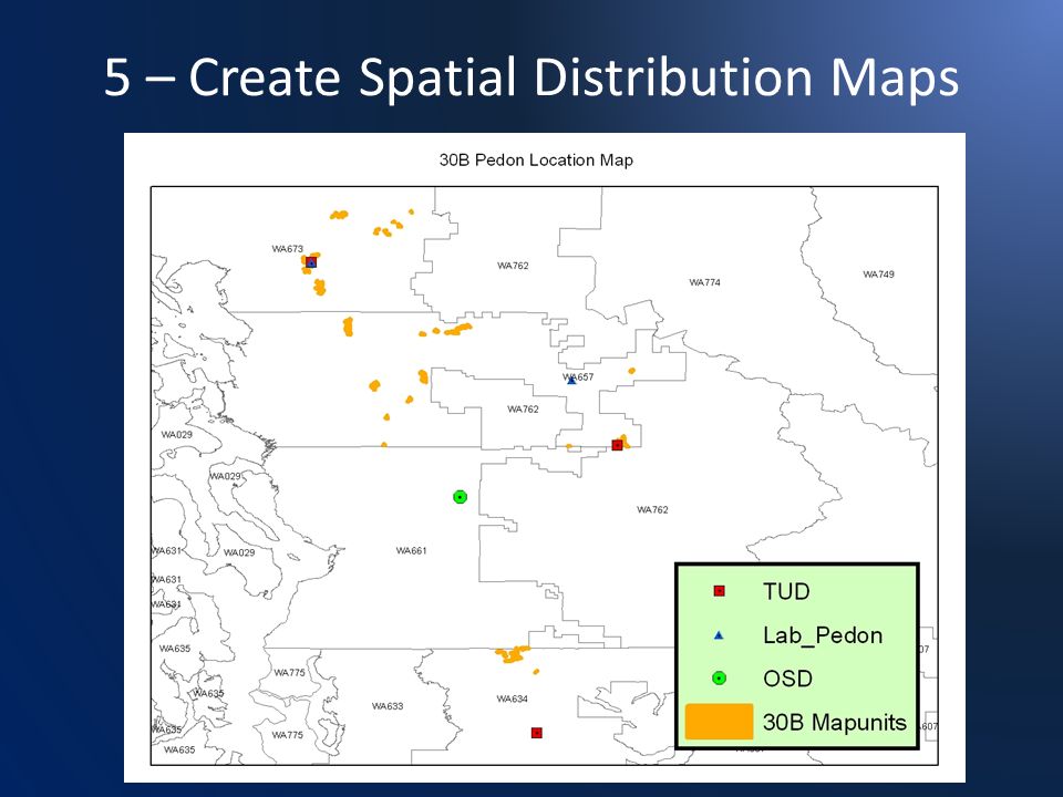
5 – Create Spatial Distribution Maps Store in electronic folder ›Map unit distribution ›Thematic maps ›Precipitation/temperature maps ›Geology maps ›Land cover maps ›Pedon location maps ›Any map you feel is appropriate

49
5 – Create Spatial Distribution Maps

51
6 – Compile Historical Information Begin adding data to your folder ›Pedons OSD, TUDs, KSSL pedons, and/or other pedons ›MUD’s Original and newly proposed provisional map unit forms ›Links to KSSL Data ›Photos ›Correlation Information Correlation documents and trip reports ›University Data ›Vegetation Information ›Any other pertinent information

52
6 – Compile Historical Information Screen Shot of my 30B project folder

53
6 – Compile Historical Information TUDs and MUDs from published manuscripts Links to all WA, OR, and ID pdf manuscripts are available on the MO1 website Locate all pertinent TUDs and MUDS and store in electronic folder I copied the text and stored it as a word document

54
6 – Compile Historical Information Discuss map unit and series concepts with local experts who have historical knowledge ›You basically need to talk to Chad, Thor and Steve Store any information you deem pertinent in the project folder

55
7 – Enter Pedons Populate point feature class in a geodatabase ›Create points for all pedons ›Create a point spatial distribution map

56
7 – Enter Pedons Points in Geodatabase ›Allows you to control information through domains ›Will want to identify User Pedon ID and pedon types

57
7 – Enter Pedons Review OSD Classification ›Current classification: Medial, amorphic, Aquic Haplocryands In OSD remarks it says “Classification only changed 4/94 because of recent amendments to Soil Taxonomy. Fails criteria for spodic because of lack of an albic horizon.” OSD last updated 2004 How up-to-date is the Getchell classification?

58
7 – Enter Pedons Getchell OSD characteristics ›Parent Material Volcanic ash over colluvium and till ›Depth Class Moderately Deep (<100 cm) to ortstein cemented till ›Drainage Class Moderately well drained with “mottles” and “coatings” between 20-36 in ›Vegetation Includes pacific silver fir
 to ortstein cemented till ›Drainage Class Moderately well drained with mottles and coatings between in ›Vegetation Includes pacific silver fir")
59
7 – Enter Pedons Getchell lab data ›Lab data is available on two Getchell pedons, but it’s doesn’t include all of the necessary information (it’s old) ›Review & update KSSL lab pedons ›We will have to assume that this soil will meet andic, medial, and amorphic criteria ›We will add a future MLRA project indicating the need to sample Getchell
 ›Review & update KSSL lab pedons ›We will have to assume that this soil will meet andic, medial, and amorphic criteria ›We will add a future MLRA project indicating the need to sample Getchell")
60
7 – Enter Pedons Getchell OSD classification ›Currently a Haplocryands, but due to the presence of an ortstein cemented layer with in 100 cm of the soil surface, it should classify as a Duricaryands Original Classification: Medial, amorphic Aquic Haplocryands Should Classify As: Medial, amorphic Aquic Duricryands

61
7 – Enter Pedons Review TUD’s ›Are any of the TUDs’ the OSD? In project 30b, the answer is no ›Do they classify correctly and do they fall within the concept of the OSD? In all TUDs, I’m assuming andic, medial, and amorphic In all TUDs, no redoximorphic features present, but drainage class is moderately well drained – Will assume saturated conditions exist above 100 cm and the aquic subgroup is met

62
7 – Enter Pedons Review TUD’s ›WA634 TUD is MD to ortstein cemented till Within OSD concept ›WA657 TUD is MD to compacted dense till Outside OSD concept ›WA673 TUD is MD to compacted dense till Outside OSD concept Dense till is not cemented and ortstein is cemented Duricryands have a cemented layer within 100cm ›Dense till is not considered cemented, but ortstein cemented layers meet the criteria

63
7 – Enter Pedons Classifications of TUDs and OSD would vary What is the solution? How TUD’s and OSD Would Classify Survey AreaNew Classification WA661 (OSD)Medial, amorphic Aquic Duricryands WA634 (TUD)Medial, amorphic Aquic Duricryands WA657 (TUD)Medial, amorphic Aquic Haplocryands WA673 (TUD)Medial, amorphic Aquic Haplocryands
Medial, amorphic Aquic Duricryands WA634 (TUD)Medial, amorphic Aquic Duricryands WA657 (TUD)Medial, amorphic Aquic Haplocryands WA673 (TUD)Medial, amorphic Aquic Haplocryands.")
64
7 – Enter Pedons Final Decision ›Only the WA634 currently meets the OSD concept ›Yet, the OSD and TUD’s are all moderately deep to till and the use and management of the soils is not affected by the absence or presence of the ortstein ›After taking into account local knowledge, it was decided the presence of ortstein is inconsistent ›The Getchell OSD will be updated and will no longer be recognized as having an ortstein cemented layer

65
7 – Enter Pedons Final Decision ›It will be noted in the OSD range of characteristics that ortstein can occur in the dense glacial till but is not cemented enough to meet the duric subgroup ›OSD will retain classification ›All Getchell components will use the OSD as the representative pedon

66
7 – Enter Pedons Final Decision ›It will be noted in the OSD range of characteristics that ortstein can occur in the dense glacial till but is not cemented enough to meet the duric subgroup ›OSD will retain classification ›All Getchell components will use the OSD as the representative pedon ›All Getchell components will be classified as Medial, amorphic Aquic Haplocryands

67
7 – Enter Pedons Issues uncovered so far ›Need lab data for Getchell ›Need to investigate the presence of ortstein ›Need to investigate the aquic subgroup ›There are concerns about the spatial distribution of the polygons Will still proceed with harmonization but the will continue to document issues with the intention of building a future MLRA project for the Gethcell map units

68
7 – Enter Pedons Update the OSD

69
7 – Enter Pedons Update the OSD ›Currently states in Getchell OSD ›Ortstein cementation is thought to be inconsistent in the compacted till Changed the 2Bsm to a 2Cd horizon Added a statement in the range in characteristics that states “ortstein cementation has been observed in the compacted till in some pedons” ›All TUD’s will now fall in the concept of the OSD

70
7 – Enter Pedons Enter pedons into NASIS ›Identify the representative Getchell pedon (which in this example is the OSD) ›Locate all existing Getchell pedons in NASIS ›Update existing pedons in NASIS to current standards ›Enter missing TUDs, OSD, and other Getchell pedons Update classifications and horizonation
 ›Locate all existing Getchell pedons in NASIS ›Update existing pedons in NASIS to current standards ›Enter missing TUDs, OSD, and other Getchell pedons Update classifications and horizonation")
71
7 – Enter Pedons Enter pedons into NASIS ›Pedon data entry guidance is forthcoming ›An updated NASIS 6.2 Pedon entry thunderbook should be available soon

72
7 – Enter Pedons Generate new TUD ›Use MO1 Technical Note 45 – Taxonomic Unit Description ›The range in characteristics and the RV profiles will be used to populate the component in your new MLRA map unit ›The TUD will be included in your project folder

73
8 – Review map units, DMUs and GIS Conduct surface analysis on project map units Review the MUD’s for map unit composition and map unit concept Review, up date, and utilize data in DMU’s and manuscript tables

74
8 – Review map units, DMUs and GIS Used Whityn’s pivot tables generated from tabulate areas to conduct surface analysis I only reviewed slope in this example due to time constraints, but ideally I would review elevation and aspect I used the pivot tables to generate charts that show the distribution of slope

75
8 – Review map units, DMUs and GIS Surface analysis results (slope) 74142: 30-65 % slopes 74845: 30-60 % slopes 75124: 30-60% slopes Used MUKEYs to identify map units 74142 is MUKEY for WA634 74845 is MUKEY for WA657 75124 is MUKEY for WA673
 74142: % slopes 74845: % slopes 75124: 30-60% slopes Used MUKEYs to identify map units is MUKEY for WA is MUKEY for WA is MUKEY for WA673")
76
8 – Review map units, DMUs and GIS Surface analysis (slope) 74142: 30-65 % slopes 74845: 30-60 % slopes 75124: 30-60% slopes MUKEY 74142 occurs in WA634. It is clearly not mapped on the same landforms as the other two map units. Appears to be more like a 0-40 % slope. 74845 & 75124 have almost identical distributions.

77
8 – Review map units, DMUs and GIS 74142: 30-65 % slopes 75122: 3-30 % slopes The problem mapunit, 74142, is checked against a Getchell 3-30 % slope map unit (MUKEY 75122 from WA673). The 74142 map unit has a similar distribution to that of the 3 to 30% map unit. The slope analysis has affected the project. The 74142 (WA634) map unit will be removed from this SDJR project and placed in a future MLRA project.
 map unit will be removed from this SDJR project and placed in a future MLRA project..")
78
8 – Review map units, DMUs and GIS So far: ›WA634 Getchell 30-65% slopes will be removed form the SDJR project ›WA657 and WA673 Getchell 30-60% slopes have similar slope distribution and will be grouped together ›Need to determine slope for the new map unit based on the combined distribution of the WA657 and WA673

79
8 – Review map units, DMUs and GIS Both remaining Getchell map units are shown separately in this screen shot Here, they are now grouped together

80
8 – Review map units, DMUs and GIS What is the slope of the new MLRA map unit? This is a subjective decision. Try to retain the original concept, but don’t completely ignore the data. For the new MLRA map unit, I’ve decided on using a slope phase of 20-60%, with an RV of 35%. This keeps the RV in the 30-60 range, but doesn’t discount the data that shows significant areas the map unit occurring on slopes less than 30.

81
8 – Review map units, DMUs and GIS Review data in WA657 and WA673 for Getchell components (WA634 map unit removed) ›How similar is the data? Identical data elements – LCC – Component Forest Productivity – Component Existing Plants – Drainage Class – Component Month – Depth Class – Much of the component horizon data » Only difference is the WA657 accounted for the gravelly silt loam surface texture Based on review, I have no concerns with grouping the Getchell components

82
8 – Review map units, DMUs and GIS Read MUD’s in original manuscripts ›Are they similar? ›What are the minor components? Most of the older surveys will not have minor components populated in NASIS, but they will be listed in mansuscript

83
8 – Review map units, DMUs and GIS Check surface textures ›WA673 – Loam ›WA657 – Gravelly silt loam ›OSD – silt loam Timber production is major use and management concern, surface texture is not a big correlation issue in this example. Using the OSD surface texture will suffice

84
8 – Review map units, DMUs and GIS WA657%WA673% GETCHELL85GETCHELL85 crinker--hartnit -- deep soils--oso -- rock outcrop--revel -- soils < 20” to till -- rock outcrop -- poorly drained soils -- getchell on slopes > 65 -- getchell on slopes < 30 -- Map units as they exist in the manuscript MUDs Each map unit stated Getchell comprised 85% of the map unit and there were 15% minor components of varying soils. As you decide on what minors to include, keep the dissimilar model of correlation in mind.

85
8 – Review map units, DMUs and GIS WA657DepthWA673Depth GETCHELLMDGETCHELLMD crinkerMDHartnitMD deep soils--OsoMD rock outcrop--RevelMD soils < 20” to till-- rock outcrop-- poorly drained soils-- getchell on slopes > 65-- getchell on slopes < 30-- Each MUD has moderately deep minor components that are Spodosols or Andisols and these components have similar site index values to those of Getchell. I decided these moderately deep soils were similar to Getchell and I will not include them in the map unit.

86
8 – Review map units, DMUs and GIS WA657DepthWA673Depth GETCHELLMDGETCHELLMD crinkerMDHartnitMD deep soilsVD or DOsoMD rock outcrop--RevelMD soils < 20” to tillSH rock outcrop-- poorly drained soils-- getchell on slopes > 65-- getchell on slopes < 30-- Above are the dissimilar minor components. There are shallow soils, deeper soils, and miscellaneous components. Based on my review, I’ve decided to included the following components in the map unit: Very Deep soil 5% Shallow soil 5% Rock outcrop 5%

87
8 – Review map units, DMUs and GIS I looked in the survey areas that have used Getchell as a major component and I found two other major components that have the correct geographic setting, classification and depth class: ›Playco Loamy-skeletal, istotic Andic Haplocryods Very Deep ›Clendenen Medial-skeletal, mixed, super active Lithic Humicryods Shallow

88
8 – Review map units, DMUs and GIS New MLRA Map unit Component%MajorDepth GETCHELL85YesMD Clendenen5NoSH Playco5NoVD Rock Outcrop5No--

89
8 – Review map units, DMUs and GIS All minor components will be fully populated Here is the problem with SDJR: “Ripple Effect” ›I will need to repeat step 7, enter pedons into NASIS, for Playco and Clendenen This means I need to review OSD and pedons, choose a RV pedon, enter them into NASIS, and develop a TUD ›Creates a huge workload, but will get faster

90
9-Populate new MLRA DMU Populate new DMU in NASIS Use TUDs generated in step 7 Use any available lab data Follow technical note 40

91
10 – Document the new map unit & DMU Update the map unit name to Getchell 20-60% slopes Populate the map unit text table with your concept of the MLRA map unit ›Include any information you discovered about the map unit during harmonization ›Include correlation decisions in the Text Entry ›Enter Kind – map unit description Category – map unit concept

92
10 – Document the new map unit & DMU Populate the map unit text table with your concept of the MLRA map unit ›Geomorphology ›Parent material ›Areas where it occurs ›Major land use ›Important properties ›Original concept in manuscript ›How and why did you decide on your minor components ›Any other important information Enter ›Kind – map unit description ›Category – map unit concept

93
Be thorough, this is your chance to explain your decision making process

94
11-Identify Future Projects Extremely important Basically developing a thorough MLRA long range plan This may be how your MLRA SSO is evaluated in the future Be thorough

95
11-Identify Future Projects During our work on 30b, we have identified the following issues: ›Lab data is needed Is Getchell medial, amorphic and an andisol? ›The presence and/or absence of ortstein should be reviewed ›Ecological sites are needed ›The map unit in WA634 could not be harmonized due to the results of the slope analysis Is on a different landform than other map units in the project ›A mis-join was identified between the Getchell map unit in WA634 and a map unit WA661 ›The spatial extent of Getchell is in question

96
Mis-Join WA661 map unit Getchell – Oso complex, 15 to 30 percent slopes WA634 map unit Getchell silt loam, 30 to 65 percent slopes Actual slope of the WA634 Getchell map unit fit the 15 to 30 range better

97
11-Identify Future Projects Create a future MRLA project electronic folder ›I have spent time and resources in the evaluation of Getchell ›I want to store all of my evaluation findings in a future project folder and place it on the MO1 sharepoint ›Items included will be similar to the folders created for the SDJR projects

98
11-Identify Future Projects A new future MLRA project is created ›Populate Project name – Since this project deals with the Getchell series and not just a map unit, I only included Getchell in the project name – MLRA – MLRA 3 – Getchell Project description Approval MLRA SSO State Responsible Project Mapunit table

99
11-Identify Future Projects Project Description ›Describe all of the issues known about this proposed project

100
11-Identify Future Projects Project Mapunit ›Add all appropriate map units ›In this instance, since the Getchell concept is in question, all Getchell map units are included

101
11-Identify Future Projects No acre goals assigned at this time Can keep adding to the MLRA project as you work on other map units You will have a good bit of freedom to develop the future projects as you see fit

102
12-Update OSD and Lab Data OSDs were updated in step 7 ›Submit the updated OSDs to the MO Submit changes to MO for KSSL pedons and sites and/or other pedons you don’t have permission to edit in NASIS

103
13- QC 100% quality control is conducted on your new map unit and data map unit ›Use MO1 Technical note 38 Once completed, notify MO and they will begin the QA process Notify MO of any future projects you have identified

104
13 & 14- QA and Certificaiton Project goes through QA and is certified The new MLRA Getchell map unit is the new official data in WA657 and WA673

105
14 – Progress Reporting After SSURGO certification, I can report progress in the Project Mapping Progress table Goal was 1131 acres, which is 20% of total acre ›Getchell map units originally included in the project totaled 5653 543 acres removed because WA634 map unit is not longer included 5,653 - 543 = 5,110 acres 5,110 * 0.20 = 1,022 ›I will report 1,022 acres in the Project Mapping Progress table

Similar presentations


 for your survey area ► Open ArcToolbox ► Unzip the Digital Soil Survey – Pedon.>")
 732-7188 GIS and Mapping Procedures in ArcMap 9.x Creating an ArcMap Project Editing an ArcMap Project Printing an ArcMap Project.>")


