Download presentation
Presentation is loading. Please wait.

1
WARM UP: Monday, March 3 Get out a sheet of notebook paper & something to write with. Answer the following three questions on the paper. Describe the climate of Southwest Asia in one well-written, complete sentence. Include information about vegetation, temperature, landforms, etc. What economic activity do many SW Asian countries rely on? What are the 5 Pillars of Islam?

2
Southwest Asia & Northwest Africa
Physical Geography

3
Chapter 7: Southwest Asia & North Africa (Fig. 7.1)
Globalization & Diversity: Rowntree, Lewis, Price, Wyckoff

4
Introduction SW Asia and North Africa extend 4,000 miles
This region is a cultural hearth – a region that witnesses many cultural innovations that subsequently diffuse to other parts of the world. Development of petroleum industry has had a large impact on the region. OPEC (Organization of Petroleum Exporting Countries) – member countries profoundly influence global prices and production targets for petroleum. Islamic fundamentalism – this aspect of Islam advocated return to more traditional practices, call for merger of civil and religion authority and challenges encroachment of global popular culture.
 – member countries profoundly influence global prices and production targets for petroleum. Islamic fundamentalism – this aspect of Islam advocated return to more traditional practices, call for merger of civil and religion authority and challenges encroachment of global popular culture.")
5
Crossroads of Continents
Africa Europe Asia

6
North Africa’s Climates
North Africa’s major climates are Arid (Desert) & Semi-arid (Steppe).
 & Semi-arid (Steppe).")
7
The Arabian Peninsula is primarily steppe and desert climate as well.
The Arabian Peninsula’s Climate The Arabian Peninsula is primarily steppe and desert climate as well.

8
The Arabian Peninsula’s Climate
The Rub ‘al-Khali, or “Empty Quarter,” is a large desert in Saudi Arabia. It is the largest area of continuous sand in the world. The climate is extremely arid. Few places receive more than 7 inches of rain per year, and no permanent streams exist. Summer temperatures reach as high as 130º F in some areas.

9
Atlas Mountains Separates the northern moist Mediterranean climate from the arid south.

10
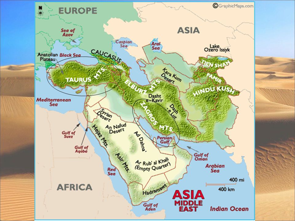
Middle East Mountains Taurus Zagros
Spreads across Turkey. High point – Mt. Ararat – 16,583 ft. Trivia: Biblical historians believe Noah’s Ark landed here. Zagros Extend through southwestern Iran, and through northern Iraq Highest point- Zard Kuh, 14, 921 ft. Mt. Ararat

12
Water Water is the most precious resource for this region and several large bodies of water in the area play a major role in world politics. Examples: Persian Gulf, Strait of Hormuz, Arabian Sea, Red Sea. Many river valleys dependent on seasonal floods. Alluvial soil around the river and the delta regions are especially good for farming. Nile River (longest river in the world), Tigris and Euphrates Rivers (home to the world’s first major civilization), Jordan River.
, Tigris and Euphrates Rivers (home to the world’s first major civilization), Jordan River.")
13
Oases An oasis is a place where water comes to the surface in desert area. “Oasis" is believed to come from an ancient Egyptian word, "wah," meaning "fertile place in the desert." About 75 percent of the Sahara's population live in oases.

14
Managing Resources: Water
Desalination – the removal of salt from ocean water. Drip Irrigation – using small pipes that slowly drip water just above ground to conserve water used for crops.

15
Aswan High Dam Built in 1971. 365 ft. high.
Created an artificial lake – Lake Nasser – which covers 300 miles.

16
Aswan High Dam Positive Effects Negative Effects
Prevents flooding, control irrigation, hydroelectric power, increased amount of farmland by 2.9 million acres. Negative Effects New layer of fertile soil no longer deposited by annual flood, so farmers must use fertilizers – very expensive & run-off pollutes river/kills fish. New soil not added to Nile River Delta which causes erosion

17
Aswan High Dam More negative effects
Stagnant water allows disease to increase. Salt content has increased, which can ruin crops. Some experts think weight of Lake Nasser may be producing earthquakes.

18
Suez Canal Construction completed in 1869.
The 101-mile waterway connects the Mediterranean Sea to the Red Sea. The Suez Canal is used to transport goods to and from the three nearby continents. Why would the Suez Canal be important to control during a worldwide war?

19
Strait of Hormuz Why is this an important body of water?

20
Major Water Features Tigris River Euphrates River

21
The Fertile Crescent

22
The Fertile Crescent Greeks called this region Mesopotamia, which means “between the rivers.” Many different civilizations developed in this small region. Sumerians Assyrians Babylonians This area is in modern-day Iraq.

23
Dead Sea Lowest point on earth – 1320 ft. below sea level.
Saltiest water in the world.

24
Southwest Asia & Northwest Africa
Human Geography

25
Population Geography All but three of the countries are Arab nations & speak Arabic – Turkey, Iran, & Israel are the non-Arab countries. More than 400 million people in the region. Physiological densities among Earth’s highest – this means that the number of people compared to the amount of arable land

26
Water & Life: Rural Settlement Patterns
Pastoral Nomadism Traditional form of subsistence agriculture based on seasonal movement of livestock Oasis Life Small agricultural settlements Serve as trade centers as well The Challenge of Dryland Agriculture Depends on seasonal moisture Includes tree crops, livestock, grains, & other crops

27
Agricultural Regions of SW Asia & N Africa (Fig. 7.14)
Globalization & Diversity: Rowntree, Lewis, Price, Wyckoff

Similar presentations

>")


