Download presentation
Presentation is loading. Please wait.

1
Geographic Patterns and Profiling of Illegal Land Border Crossings D. Kim Rossmo Quint C. Thurman

2
Border Control Geographic range Porous nature US national security Significant challenge Rugged terrain of El Paso border

3
The Illegal Border Crossing “Arms Race” Ground sensor and UAV Fencing and electronic gate Trucks in Rio Grande canyon Inner tubes along the Rio Grande

5
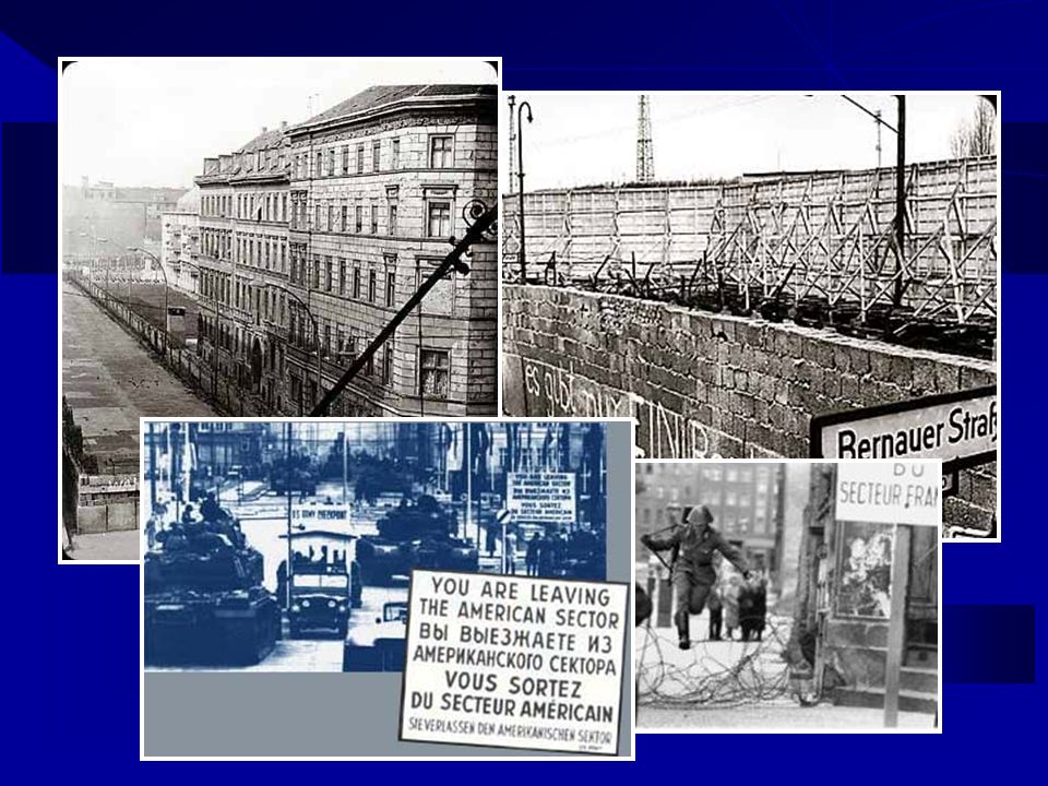
Berlin Wall 10,315 days August 1961 to November 1989 East / West Berlin border 27 miles West Berlin border 96 miles 12-foot wall, 302 watch towers, 20 bunkers 192 deaths, 200 shooting injuries 5,000 escapes (3.4 per week)
")
6
US Border Patrol Sectors

7
Texas- Mexico Border 1,000 miles 52% of southern border 1,933 miles 50% federal land

8
Theoretical Perspective Criminal behavior Bounded rationality Shaped by personal and environmental factors Migration theory Origin (push) factors Destination (pull) factors) Distance (effort, time, money) Cost/benefit (risk/reward) analysis framework
 factors Destination (pull) factors) Distance (effort, time, money) Cost/benefit (risk/reward) analysis framework")
9
Illegal Border Crossing Requirements Trip origin Border Staging area Crossing Landing Trip destination

10
Premise Identify border crossing factors Facilitating Inhibiting Determine features related to probability of illegal border movement Environmental Physical

11
US Border Patrol Data 2001 to 2004 (4 years) 1 to 1.6 million cases annually in the US 20 to 25% of these cases are in Texas Laredo, McAllen, Del Rio, Marfa, and El Paso Sectors
 1 to 1.6 million cases annually in the US 20 to 25% of these cases are in Texas Laredo, McAllen, Del Rio, Marfa, and El Paso Sectors")
12
Dependent Illegal Texas-Mexico land border crossings Independent Physical geography Human geography Research Variables

13
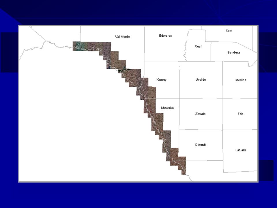
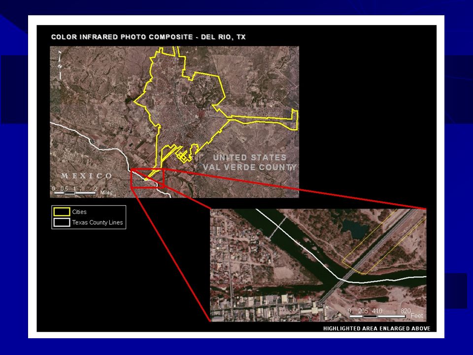
Preliminary Focus Area Del Rio Border Patrol Sector Val Verde, Kinney, & Maverick Counties 111 Landmark Mile Markers (170 miles)
")
15
Physical Geography Hydrography Terrain Vegetation Temperature (day and night)
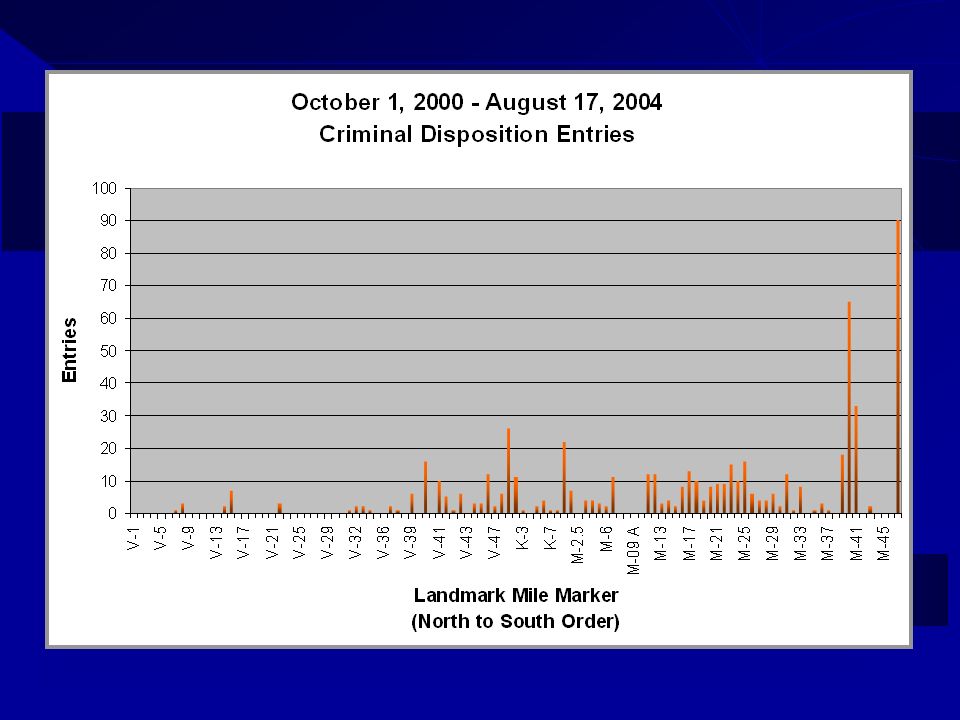
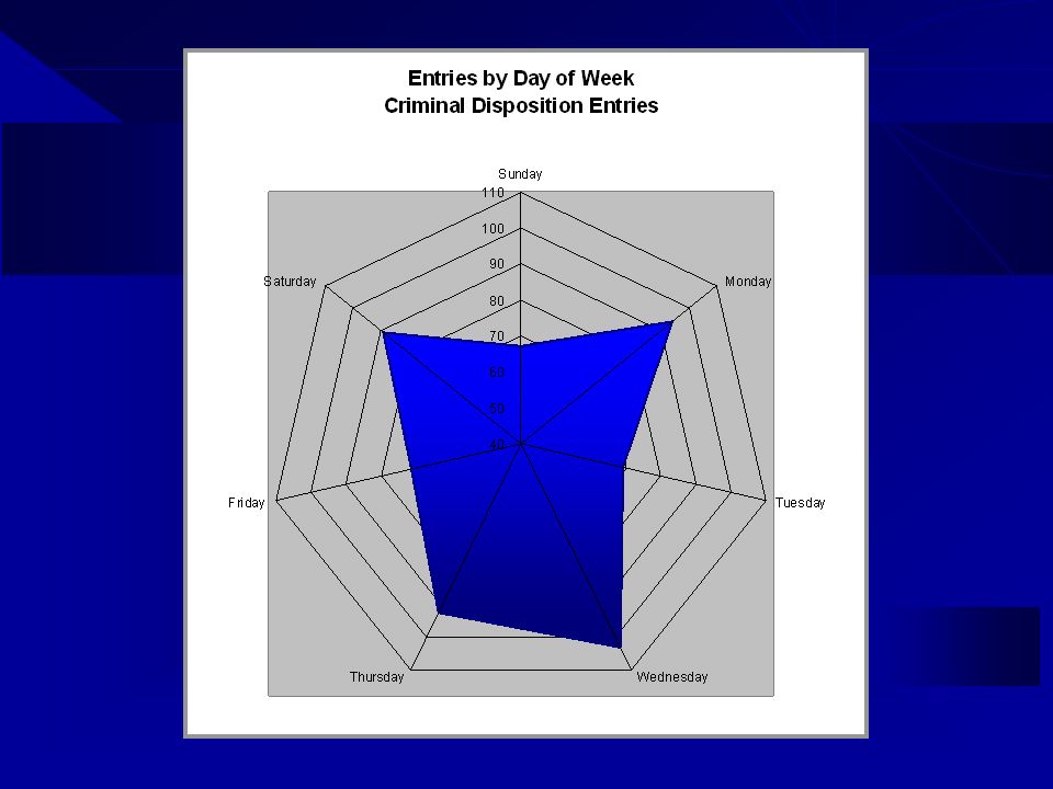
")
16
Hydrography Types of features Streams Rivers Lakes Reservoirs Data sources US Census (USA) INEGI (Mexico)
 INEGI (Mexico)")
17
Terrain (USGS DEM) Extent All counties Mexico overlap Primary Output Elevation Slope Aspect Hillshade Identification Ravines Gullies
 Extent All counties Mexico overlap Primary Output Elevation Slope Aspect Hillshade Identification Ravines Gullies")
19
Vegetation Types of features Brush Crops Parks Woods Data sources TPWD (US) INEGI (Mexico)
 INEGI (Mexico)")
20
Temperature Monthly normals Minimum Maximum Annual normals Mean

21
Human Geography Variables Major transportation Population density Urban developments Political region Additional features

22
Major Transportation Types Airports Railroads Roads Bridges US data sources US Census TCEQ Mexico data sources GeoCommunity

23
Population Density & Urban Development US data 2000 US Census All counties Mexico Data 1990 Census Mexico

28
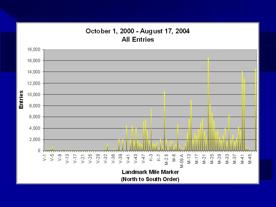
Del Rio Illegal Border Crossings

29
Del Rio Illegal Border Crossings (Cumulative %) G = 0.64 ID = 0.49
 G = 0.64 ID = 0.49")
30
Del Rio Sector – All Illegal Entries 2000 14,520 2001 86,974 2002 61,974 2003 53,744 2004 37,534 2000-04254,717

31
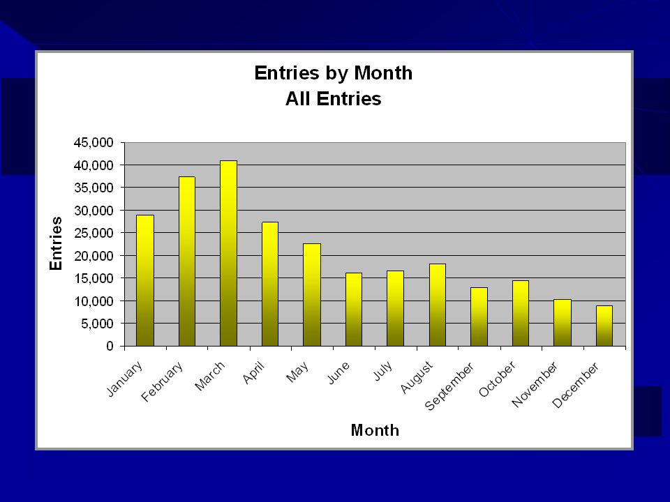
All Entries

32
Del Rio Sector – Criminal Entries 2000 - 2001 5 2002 129 2003 289 2004 162 2000-04 585

33
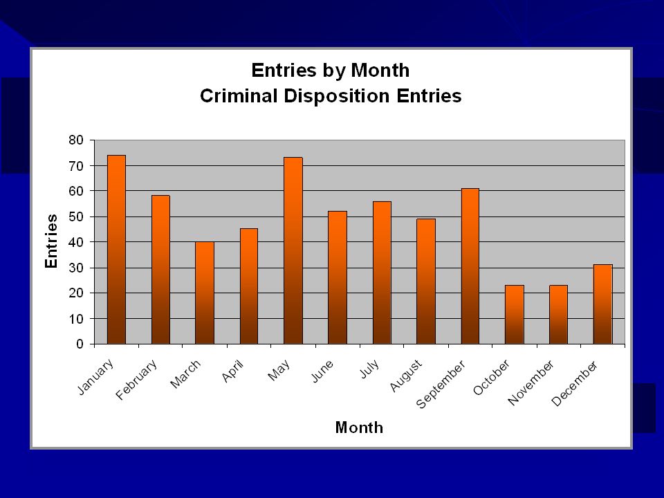
Criminal Entries

34
Density of Del Rio Sector Illegal Entries

43
Residence Country (Excluding Mexico)
")
44
US or Mexico State of Birth

45
Gender

46
Apprehension Age

47
Distance to United States Urban Areas

48
Distance to Mexico Urban Areas

49
Slope Least Cost Path Cost-weighted distance (higher slope = greater cost) Cost-weighted direction (least cost direction to source) Least cost path (to rural highway segments)
 Cost-weighted direction (least cost direction to source) Least cost path (to rural highway segments)")
50
Combined Slope Cost-Weighted Distance Top 10 criminal disposition entry Landmark Mile Markers Weighted by number of criminal disposition entries 323 total entries

51
Slope Cost Distance Analysis Travel across terrain values is more difficult (higher “cost”) Border areas with low slope cost values are attractive to illegal border crossers
 Border areas with low slope cost values are attractive to illegal border crossers")
52
Elevation Change Analysis Border areas with higher elevation on the Mexico side are attractive to illegal border crossers Elevation differentials allows for surveillance of US Border Patrol vehicles

53
Viewshed Analysis The viewshed (line of sight) identifies all locations visible from a given point Areas with low viewshed values are attractive to illegal border crossers due to low detection risk
 identifies all locations visible from a given point Areas with low viewshed values are attractive to illegal border crossers due to low detection risk")
54
Illegal Border Crosser Population Estimates Official estimates: +10 to 50% Line officer estimates: +100%

55
Capture-Recapture Analysis P S1S1 S2S2 O P = S 1 S 2 O ?

56
Scholarly Outcomes Illegal movements International migration Spatial displacement Natural and built factors Microlevel environmental influences

57
Practical Products US Border Patrol operations Unidentified crossing points Displacement anticipation Criminal and drug interdiction Counter-terrorism applications Training

Similar presentations


 Blue -hydrography or water features (stream, river, lake, swamp,>")


